Monthly Archives: November 2015

High Cirrus over west Texas and Fog on the Ground

GOES13BTD_IFRProb_1100_30Nov2015toggle

GOES-based GOES-R IFR Probabilities and GOES-13 Brightness Temperature Differences (10.7 µm – 3.9 µm), 1100 UTC on 30 November 2015 (Click to enlarge)

Extratropical cyclones are accompanied most time with multiple clouds levels. In the example above, a cirrus shield accompanies a subtropical jet over the southern boundary of the United States. That cirrus prevents the satellite from seeing any low clouds that may be present. To detect/diagnose low clouds and fog in such regions, other data sets must be used. For GOES-R IFR Probability fields (shown in the toggle above), that other data set is low-level saturation in the Rapid Refresh model. If the model suggests saturation is present, IFR Probability fields will show a strong signal even where cirrus shields prevent the satellite from viewing water-based clouds near the surface. That is the case above. IFR conditions are widespread in the scene above are are diagnosed quite well by the IFR Probability fields.

Are IFR Conditions Present?

SNPP_BTD_DNB_0731_24Nov2015toggle

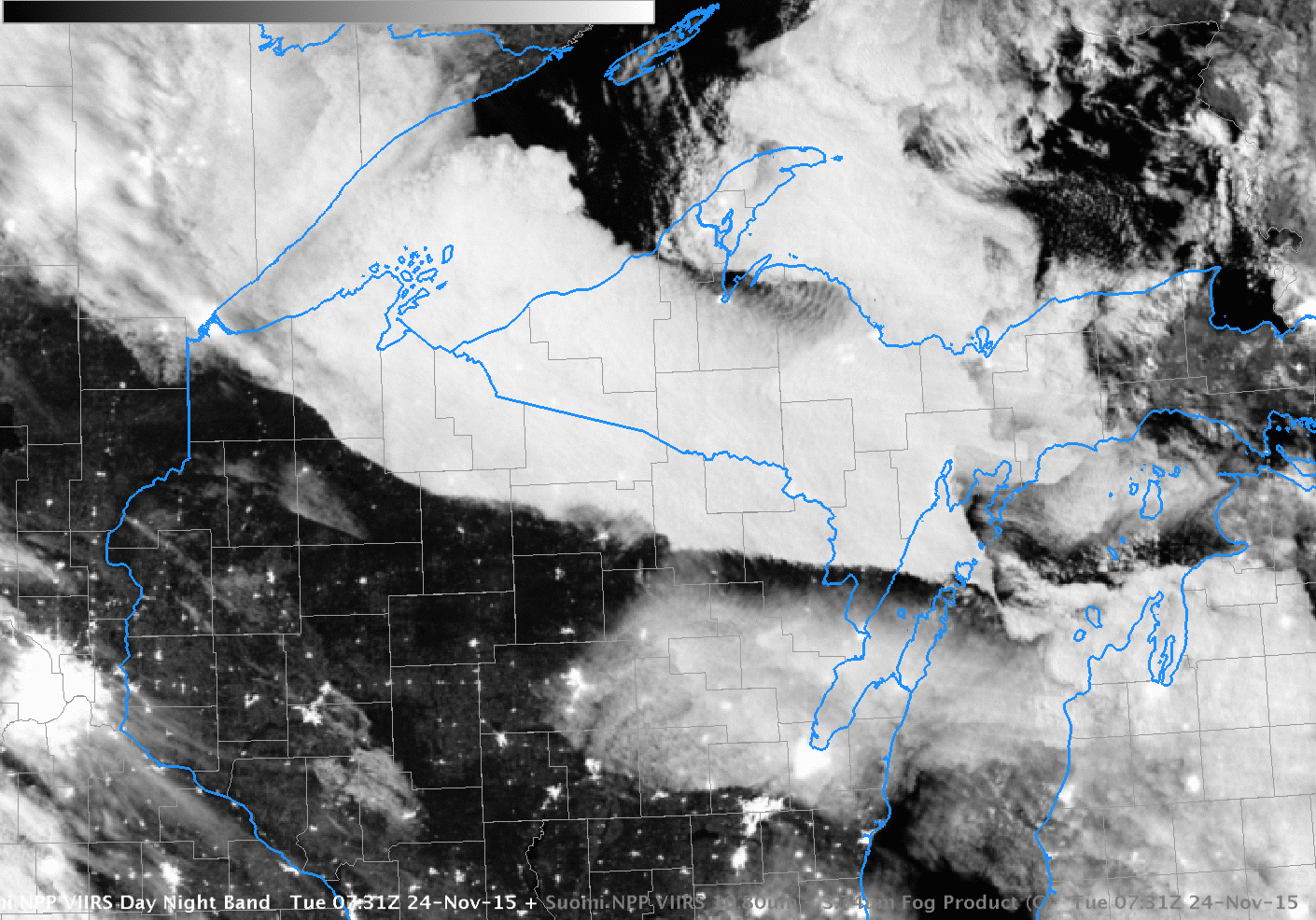
Suomi NPP Visible (0.70 µm) Day Night Band Imagery and Infrared Brightness Temperature Differences (11.45 µm – 3.74 µm), 0731 UTC on 24 November 2015 (Click to enlarge)

Low clouds (with a sharp southern edge) were over northern Wisconsin during the early morning of 24 November 2015. Are IFR Conditions present? Can you tell from the satellite imagery alone? The cloud bank stretched over northern Wisconsin seems thick compared to the bank of clouds over northeastern Wisconsin (centered on southern Green Bay). The city lights of Duluth are not visible in the same way that the city lights of Green Bay are in the Day Night band imagery. Clouds in general are distinct with the near-full moon providing ample illumination.

Both GOES and MODIS Brightness Temperature Difference fields, below, show a signal consistent with low clouds over most of northern WI and adjacent regions.  But are there IFR Conditions?

GOES_MODS_BTD_0749_24Nov2015toggle

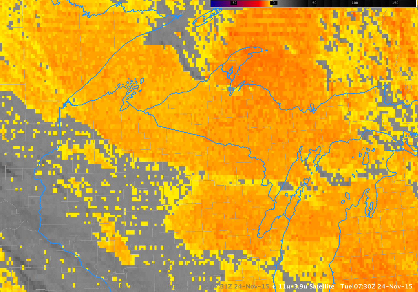
GOES-13 Brightness Temperature Difference (10.7 µm – 3.9 µm) Fields (0730 UTC) and MODIS Brightness Difference Fields (11 µm – 3.9 µm) (0749 UTC)

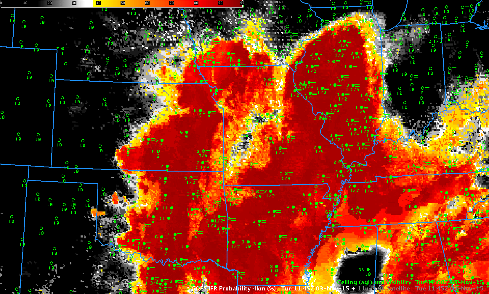
IFR Probability fields blend the information available from satellite (are water-based clouds present?) with model output to yield a refined diagnostic of IFR Conditions. If there is saturation in the lowest levels (the lowest 1000 feet) of the model, then Probabilities of IFR Conditions are increased. If the lowest levels of the model are relatively dry, in contrast, then IFR Probabilities are reduced. On the morning of 24 November, the latter condition occurred over northern Wisconsin. IFR Probabilities computed from MODIS and GOES-13 satellite values are shown below. Probabilities are very low over most of Wisconsin where mid-level stratus (with varying bases) was present: IFR conditions were not generally observed in the regions where water-based clouds were indicated by the satellite. Mid-level stratus can look, from the top, very similar to fog, but it’s impossible for the satellite alone to discern what’s happening at the cloud base. Model data helps the IFR Probability algorithm screen out regions where mid-level stratus is occurring.

MODS_GOES_IFR_OBS_0731_24Nov2015toggle

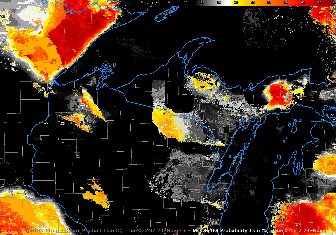
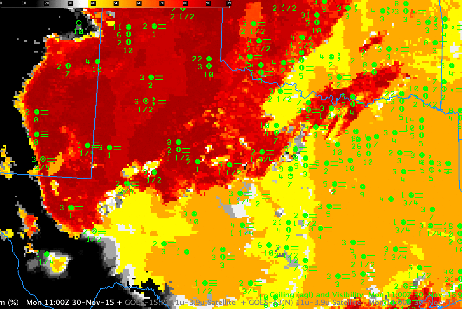
MODIS-based GOES-R IFR Probabilities (0751 UTC), GOES-13-based GOES-R IFR Probabilities (0731 UTC), and GOES-based GOES-R IFR Probabilities with surface observations of ceilings and visibilities (Click to enlarge)

Freezing Fog over Minnesota

GOESR_IFR_0515_1300_22Nov2015anim

GOES-R IFR Probability fields, hourly from 0515 through 1300 UTC on Sunday 22 November 2015 (Click to enlarge)

On Sunday 22 November, fog developed over west-central Minnesota with sub-freezing temperatures on the ground. The animation of the GOES-R IFR Probability fields, above, shows the slow enlarging of highest probabilities in the region around Glenwood and Alexandria where IFR Conditions were observed.

The Brightness Temperature Difference fields, below, show a signal over much of the region. One of the benefits of GOES-R IFR probability fields is that the use of Rapid Refresh model output screens out regions where mid-level stratus is more likely. Only regions in the model that have low-level saturation show the highest IFR Probabilities. GOES-R IFR Probabilities also give a consistent signal for IFR conditions when high clouds move over a surface fog. At the end of the animation above, probabilities decrease somewhat in regions over western Minnesota where high clouds are encroaching. Those high clouds prevent the brightness temperature difference field, below, from detecting surface fog.

GOES13_BTD_0515_1300_22Nov2015anim

GOES-13 Brightness Temperature Difference Fields (10.7µm – 3.9µm), hourly from 0515 through 1300 UTC on Sunday 22 November 2015 (Click to enlarge)

IFR Conditions with a strong extratropical Cyclone

NewEngland_1300_1400_12Nov2015toggle

GOES-R IFR Probability Fields (from GOES-13 and the Rapid Refresh Model), 1300 and 1400 UTC on 12 November 2015 (click to enlarge)

Strong Extratropical Cyclones, such as the one affecting the central and eastern United States on 11-12 November 2015 (1200 UTC Map on 12 November is here), generate multiple levels of clouds that make it difficult to detect fog/low stratus from satellite, because intervening cloud layers get in the way. GOES-R IFR Probability fields, however, because they incorporate near-surface information from the Rapid Refresh Model, can yield useful information about the likelihood of IFR Conditions. The toggle above shows data at 1300 and 1400 UTC over the northeast United States.  Highest IFR Probabilities are removed from the coastlines of New England — as observations confirm.  Note how the Adirondack and Catskill regions have higher probabilities, where terrain is reaching up into the stratus deck.  Features in the IFR Probability field are strongly related to surface-based observations of fog and low stratus.

The toggle below shows IFR Probability fields and GOES-13 Brightness Temperature Differences as 1300 UTC.  Features in the brightness temperature difference field have no relationship to surface-based observations of fog and low stratus.

NewEnglandIFR_BTD_1300_12Nov2015toggle

GOES-R IFR Probability Fields (from GOES-13 and the Rapid Refresh Model) and GOES-13 Brightness Temperature Difference fields (10.7µm – 3.9µm), 1300 UTC on 12 November 2015 (click to enlarge)

Fog over Kansas

4Panel_0500_1300_10Nov2015anim

GOES-R IFR Probabilities (Upper left, computed from GOES-13 and lower left, computed from GOES-15), GOES-13 Brightness Temperature Difference fields (10.7 µm – 3.9 µm, Upper right) and GOES-R Cloud Thickness (Lower Right), hourly from 0500 through 1300 UTC 10 November 2015 (Click to enlarge)

Dense Fog Advisories were hoisted over western Kansas in response to the development of dense fog in the early morning on 10 November 2015.  The hourly evolution of GOES-R IFR Probabilities (top left, bottom left), GOES-13 Brightness Temperature Difference fields (10.7 µm – 3.9 µm, upper right) and GOES-R Cloud Thickness fields (Bottom right) are shown above.

Both IFR Probability fields show highest probabilities over western Kansas where observations report IFR conditions. Portions of northern, central and eastern Kansas have strong returns in the GOES-13 Brightness Temperature Difference field, but IFR Probabilities are small and IFR conditions are not reported. In these regions, Rapid Refresh Model model output does not show low-level saturation and the IFR Probability algorithm correctly recognizes that IFR conditions are not likely despite the presence of stratus. It is the fusing of data in this way that gives the GOES-R IFR Probability field superior statistics (compared to the Brightness Temperature Difference field) in fog/low cloud detection.

Maximum cloud depth observed is more then 1200 feet. This suggests a long time before fog dissipation unless winds increase over Kansas.

GOES-R IFR Probabilities based on GOES-West show somewhat higher values than those based on GOES-East data; this difference arises because of the very oblique view of Kansas from GOES-15.

Widespread Fog over the central United States

IFR_BTD_1145UTC_3NOV2015toggle

GOES-R IFR Probability Field and GOES-13 Brightness Temperature Difference (10.7µm – 3.9µm) at 1145 UTC on 3 November 2015. Surface-based observations of ceilings and visibilities are plotted (Click to enlarge)

Fog was widespread over the central United States on the morning of 3 November, and Dense Fog Advisories were commonplace. The toggle above compares the Brightness Temperature Difference field (10.7 µm – 3.9 µm) with the GOES-R IFR Probability field at 1145 UTC on 3 November.  (This toggle is much faster)  IFR Probabilities use near-surface information in the Rapid Refresh Model to screen out regions where Brightness Temperature Difference signals are showing elevated stratus rather than fog  (For example, the region around Columbus MS).  IFR Probabilities are also low in regions with a modest brightness temperature difference return (most of eastern Nebraska, west Texas, southern Indiana along the Ohio River);  these regions do not include stations observing IFR Conditions.