Monthly Archives: April 2017

Dense Fog over the Tennessee River Valley

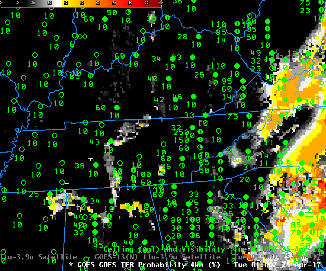
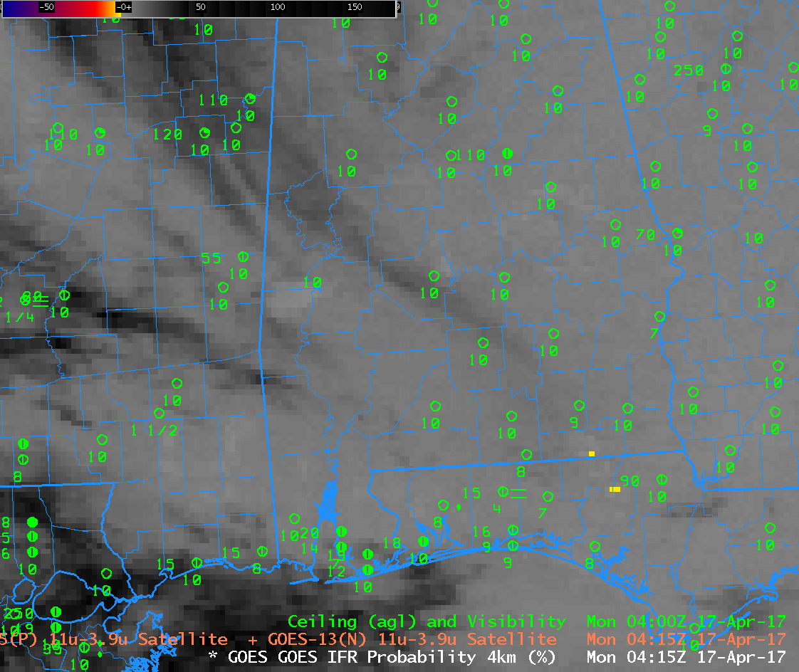
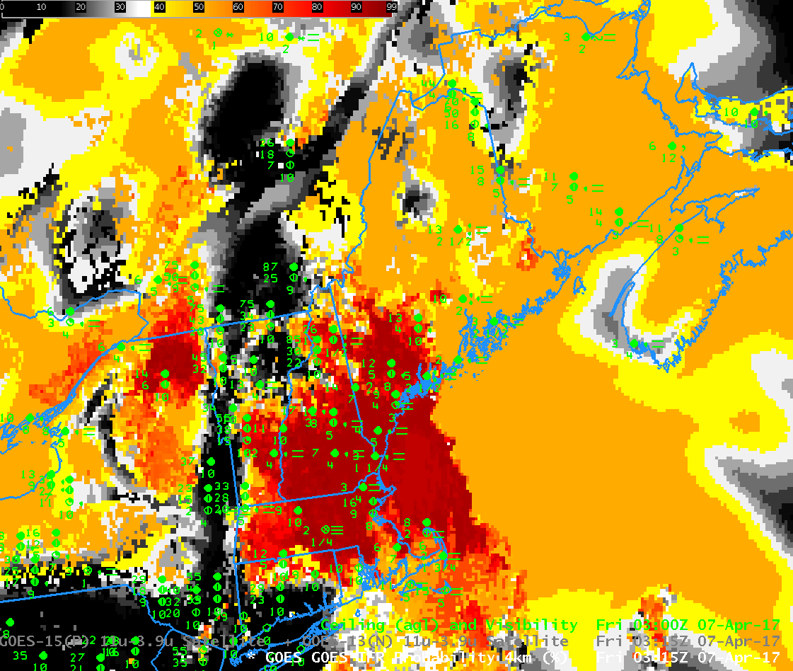
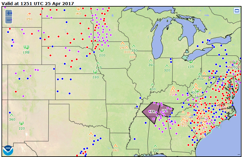
GOES-R IFR Probabilities, 0100-1315 UTC on 25 April 2017 (Click to enlarge)

Note: GOES-R IFR Probabilities are computed using Legacy GOES (GOES-13 and GOES-15) and Rapid Refresh model information; GOES-16 data will be incorporated into the IFR Probability algorithm in late 2017.

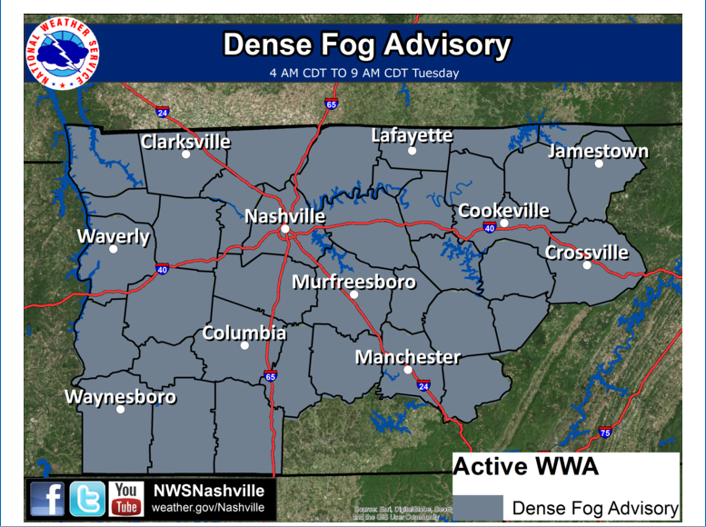
Dense Fog Advisories were issued over the Tennessee River Valley on Tuesday 25 April.   The National Weather Service Aviation Weather website highlighted the regions of IFR conditions shortly after sunrise.  IFR Probability fields, above, showed a slow increase in probabilities as ceilings and visibilities lowered during the night. The field outlined the region where IFR conditions were developing/occurring, meaning that it was a good situational awareness tool as the fog developed.

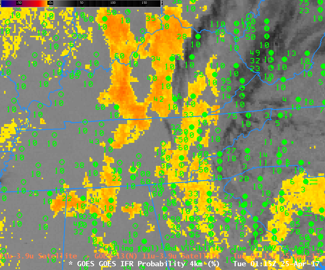
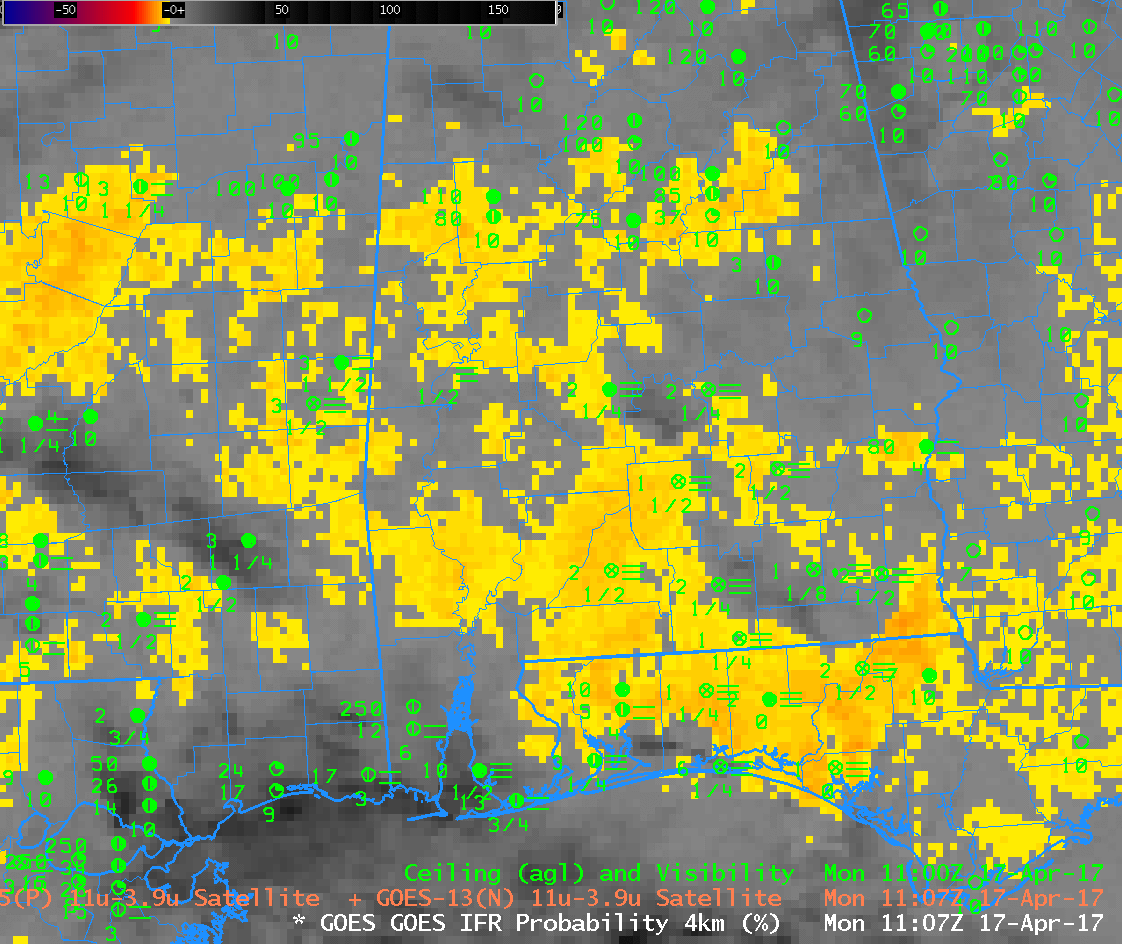
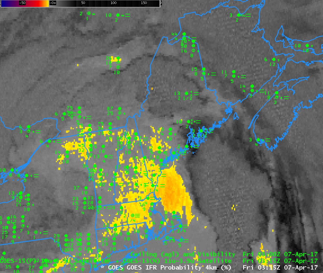
Brightness Temperature Difference fields, below, have historically been used to detect low clouds and by implication, fog. Clouds composed of water do not emit 3.9 µm radiation as a blackbody in contrast to their emissions of 10.7 µm radiation that are more like that of a blackbody. Thus, computed brightness temperature values are colder using 3.9 µm radiation than 10.7 µm radiation over water clouds. In the animation below, Brightness Temperature Difference values cooler than -1 C are highlighted in yellow.

Note that High Clouds in the animation below over the Smoky Mountains prevent an accurate depiction of low clouds formation there.  IFR Probability fields, at top, include a signal in that region because model data from the Rapid Refresh model suggests saturation is occurring.

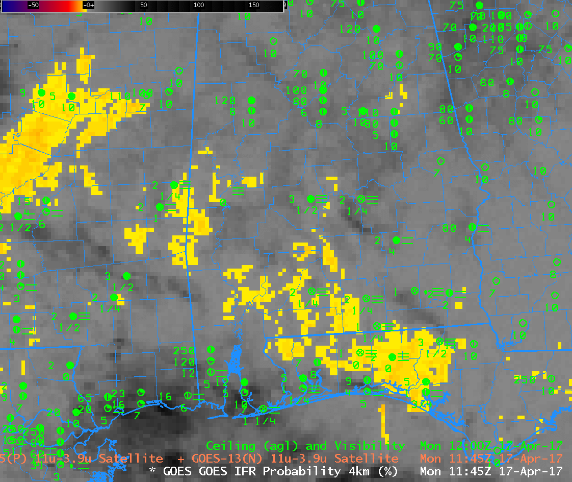
As the sun rises, at the end of the animation below, increasing amounts of reflected 3.9 µm radiation cause the brightness temperature difference field to flip in sign.  In contrast, the IFR Probability fields, at top, maintain a coherent signal through sunrise.

Alert readers may note that Brightness Temperature Difference fields and IFR Probabilities are not shown from 0400 UTC.  At that time, Stray Light signals were present in the Brightness Temperature Difference field and they contaminated both the Brightness Temperature Difference and the IFR Probability fields.

GOES-13 Brightness Temperature Difference (3.9 µm – 10.7 µm) from 0100 through 1315 UTC on 25 April 2017 (Click to enlarge)

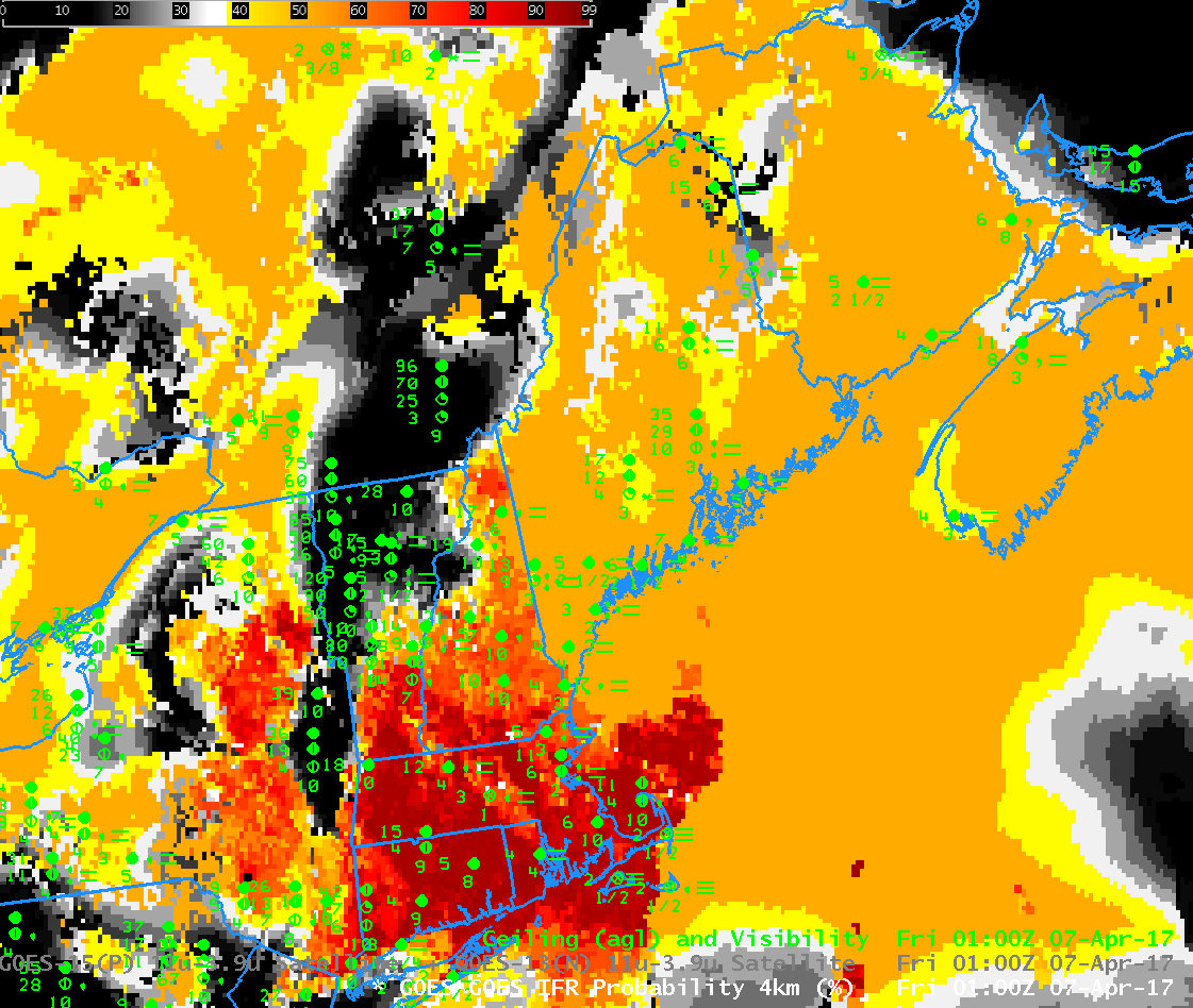
GOES-16 is transmitting non-operational data that are undergoing testing and refinement.  The toggle below shows the brightness temperature difference field from GOES-16 and GOES-13 for one time on 25 April.  Note the superior resolution in the GOES-16 data:  2 km at the subsatellite point vs. 4 km for GOES-13.  As noted at the start of this blog post, GOES-R IFR Probabilities are being computed with GOES-13 and GOES-15 data, not with GOES-16 data.  Incorporation of GOES-16 data into the algorithm will occur near the end of 2017.

The GOES-16 data posted on this page are preliminary, non-operational data and are undergoing testing.

GOES-16 and GOES-13 Brightness Temperature Difference fields, 1300 UTC on 25 April 2017 (Click to enlarge)

IFR Conditions over North Dakota

GOES-13 Brightness Temperature Difference and GOES-R IFR Probability at 0615 UTC on 24 April 2017, along with surface observations (Click to enlarge)

Note: GOES-R IFR Probabilities are computed using Legacy GOES (GOES-13 and GOES-15) and Rapid Refresh model information; GOES-16 data will be incorporated into the IFR Probability algorithm in late 2017.

A late-season snow storm was affecting North Dakota on Monday 24 April. Snow amounts were modest and IFR Conditions were widespread.   The multiple clouds layers associated with the storm meant that satellite detection of low clouds/fog was difficult.  The toggle above shows Brightness Temperature Difference (3.9 µm – 10.7 µm) and GOES-R IFR Probabilities.  The IFR Probability field distinctly outlines the region where visibilities and ceilings are restricted by the storm.  It is very difficult to discern from the Brightness Temperature Difference product where low clouds/fog exist.  Because the IFR Probability field incorporates surface information (that is, low-level saturation as predicted by the Rapid Refresh Model), it is better able to alert a forecaster to the presence of IFR or near-IFR conditions.

Dense Fog along the Florida Gulf Coast

GOES-R IFR Probability Fields, hourly from 0415-1107 UTC on 17 April 2017 (Click to enlarge)

Note: GOES-R IFR Probabilities are computed using Legacy GOES (GOES-13 and GOES-15) and Rapid Refresh model information; GOES-16 data will be incorporated into the IFR Probability algorithm in late 2017.

GOES-R IFR Probability fields, above, show increases in IFR Probability starting around midnight local time. The IFR Probability fields generally outline the regions where fog occurred (and which led to the issuance of dense fog advisories to the east of Mobile). How did the brightness temperature difference field capture this event? Brightness Temperature Difference fields have been used historically to identify regions of stratus.

GOES-13 Brightness Temperature Difference fields (3.9 µm – 10.7 µm), hourly from 0415-1107 UTC on 17 April 2017 (Click to enlarge)

The brightness temperature difference field, above, shows a slow increase in negative values (negative because the brightness temperature computed from emitted 3.9 µm radiation is cooler than that computed from emitted 10.7 µm radiation over clouds composed of water because such clouds do not emit 3.9 µm radiation as a blackbody), but careful inspection of the field shows IFR conditions in regions outside the largest signal (highlighted in this enhancement in yellow).  This occurs mostly were cirrus clouds are indicated (represented as dark regions in the enhancement, over central Mississippi, for example).  In such regions, the IFR Probability fields can maintain a signal of IFR conditions because low-level saturation is predicted by the Rapid Refresh Model.

This fused product combines the strengths of both inputs:  Satellite detection of low clouds, and model prediction of low-level saturation.

As the sun rises, the amount of reflected solar radiation at 3.9 µm increases, and the sign of the brightness temperature difference changes from negative at night over water clouds to positive.  This toggle below shows the brightness temperature difference at 1107 and 1145 UTC.  The decrease in signal does not necessarily mean fog is decreasing.

GOES-13 Brightness Temperature Difference fields (3.9 µm – 10.7 µm) at 1107 UTC and 1145 UTC on 17 April 2017 (Click to enlarge)

A toggle of the IFR Probability and the Brightness Temperature Difference at 1145 UTC, below, shows that the IFR Probability fields can maintain a useful signal during the time of rapid changes in reflected solar radiation with a wavelength of 3.9 µm.

GOES-R IFR Probability and GOES-13 Brightness Temperature Difference fields (3.9 µm – 10.7 µm) at 1145 UTC on 17 April 2017 (Click to enlarge)

IFR Probabilities with a strong storm in Maine

GOES-R IFR Probabilities, 0100-1000 UTC on 7 April 2017, along with surface reports of ceilings and visibilities (Click to enlarge)

Note:  GOES-R IFR Probabilities are computed using Legacy GOES (GOES-13 and GOES-15) and Rapid Refresh model information;  GOES-16 data will be incorporated into the IFR Probability algorithm in late 2017

A strong storm over the northeastern United States produced widespread IFR conditions over that region.  The storm was also accompanied by multiple cloud layers, however, and that made diagnosis of regions low clouds/fog difficult.  For these cases, a fused data approach is vital — using model information (in the case of IFR Probability, above, the model is the Rapid Refresh) to provide information at low levels allows for a better tool to alert a forecaster to the presence of reduced visibilities.

In the animation above, Maine intially shows IFR Probabilities around 50% — but the flat nature of the field should alert a user to the fact that satellite predictors cannot be included in the computation of IFR Probabilities because high clouds are preventing a satellite view of low clouds.  Accordingly, the computed Probability is lower.  In contrast, high clouds are not present over southern New England at the start of the animation, and IFR Probabilities are much larger there:  both satellite and model predictors are used. As the high clouds lift north from northern New England the region of higher IFR Probabilities expands from the south.

Note the influence of topographic features on the IFR Probability field.  The Adirondack Mountains and St. Lawrence Seaway have higher and lower Probabilities, respectively, because of the higher terrain in the Mountains, and the lower terrain along the St. Lawrence.

An example of why fused data are important is shown below.  Look at the conditions in Charlottetown, on Prince Edward Island, in the far northeast part of the domain.  Between 0315 and 0400, ceilings and visibilities deteriorate as IFR Probabilities increase.  The brightness temperature difference field, at bottom, shows no distinct difference between those two times because the clouds being viewed are high clouds.

Low IFR and IFR Conditions over the central United States

Note: GOES-R IFR Probabities continue to be computed with GOES-13 and GOES-15 data only. Incorporation of GOES-16 data will occur near the end of 2017.

Front Page from the Aviation Weather Center webpage (http://www.aviationweather.gov) at 1155 UTC 3 April 2017. Stations with IFR / LIFR conditions are indicated by red / magenta. (Click to enlarge)

A wide swath of Dense Fog Advisories were hoisted over the central part of the United States on Monday 3 April 2017 in association with southerly flow and a variety of fronts. The Aviation Weather Center front page (screen-captured, as shown above), showed Low IFR and IFR conditions throughout the central Plains.

The development of the Low IFR Conditions coincided with an increase in Low IFR Probabilities during the night, as shown by the stepped animation below showing data from 0200, 0500 and 0915 UTC. Low IFR Probabilities over Iowa, Nebraska and Kansas, part of a smooth yellow field, are driven solely by Rapid Refresh Data in a region where high and mid-level clouds are preventing the satellite from observing low clouds.

GOES-R Low IFR Probabilities at 0200, 0500, 0915 UTC on 3 April 2017 (Click to enlarge)

GOES-R IFR Probabilities, below, generally cover the same region as Low IFR Probabilities shown above, but have larger values. As with the Low IFR Probabilities, model data only are determining the probabilities over much of Iowa, Nebraska and Kansas, a region where the probability field is uniform and flat, especially at the end of the animation.

GOES-R IFR Probabilities at 0200, 0500, 0915 UTC on 3 April 2017 (Click to enlarge)

GOES-R Low IFR Probability is shown below with surface observations superimposed. There is a good relationship between high probabilities and observed IFR and Low IFR conditions.

GOES-R IFR Probability fields, 0945 UTC on 3 April 2017 along with surface observations of ceilings and visibilities at 1000 UTC (Click to enlarge)

Note: GOES-R IFR Probabities continue to be computed with GOES-13 and GOES-15 data only. Incorporation of GOES-16 data will occur near the end of 2017.