Monthly Archives: January 2018

Advection Fog with a strong storm in the Midwest

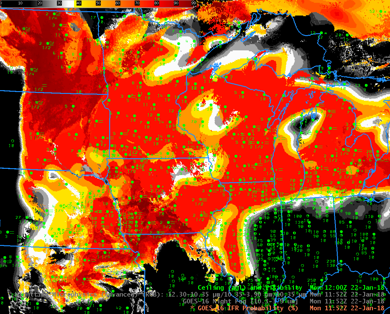
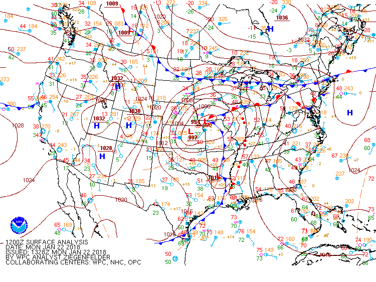
GOES-16 IFR Probabilities, 1152 UTC on 22 January 2018, along with 1200 UTC surface observations of ceilings and visibilities (Click to enlarge)

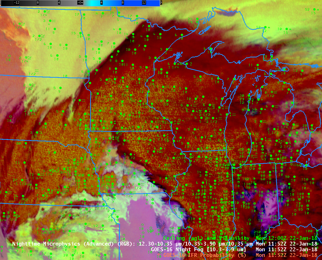
When skies are clear, and radiation fog forms, limiting visibilities, it’s straightforward to use satellite-only products to gauge where stratus and fog might exist. Extratropical storms generate multiple cloud layers, however; when warm sector air under multiple cloud layers overruns snow-covered or frozen ground, dense advection fog can develop, and that fog is difficult to discern from satellite because it is typically overlain by higher clouds.

GOES-R IFR Probabilities, above, (and Low IFR Probabilities here) show highest probabilities in general occur in the regions where IFR conditions were observed on 22 January.  Over much of Wisconsin and Minnesota, the IFR Probability field is mostly uniform.  Such a flat field is characteristic of a region where satellite data cannot be used to judge whether low stratus is present (because high clouds are also present).  Rapid Refresh model information only is used to outline regions of low-level saturation. There is more variability to the IFR Probability field — that is, it is more pixelated — over southwest Iowa, for example, and over North Dakota.  In these regions, low stratus clouds are being observed by satellite and both satellite and model data can be used to estimate regions of significantly reduced ceilings and visibilities.

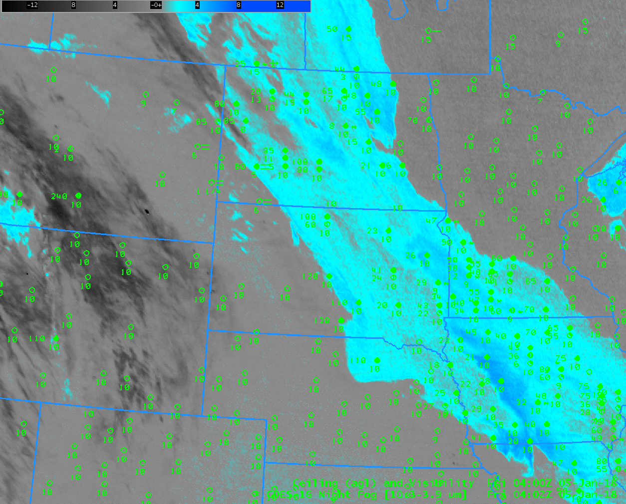
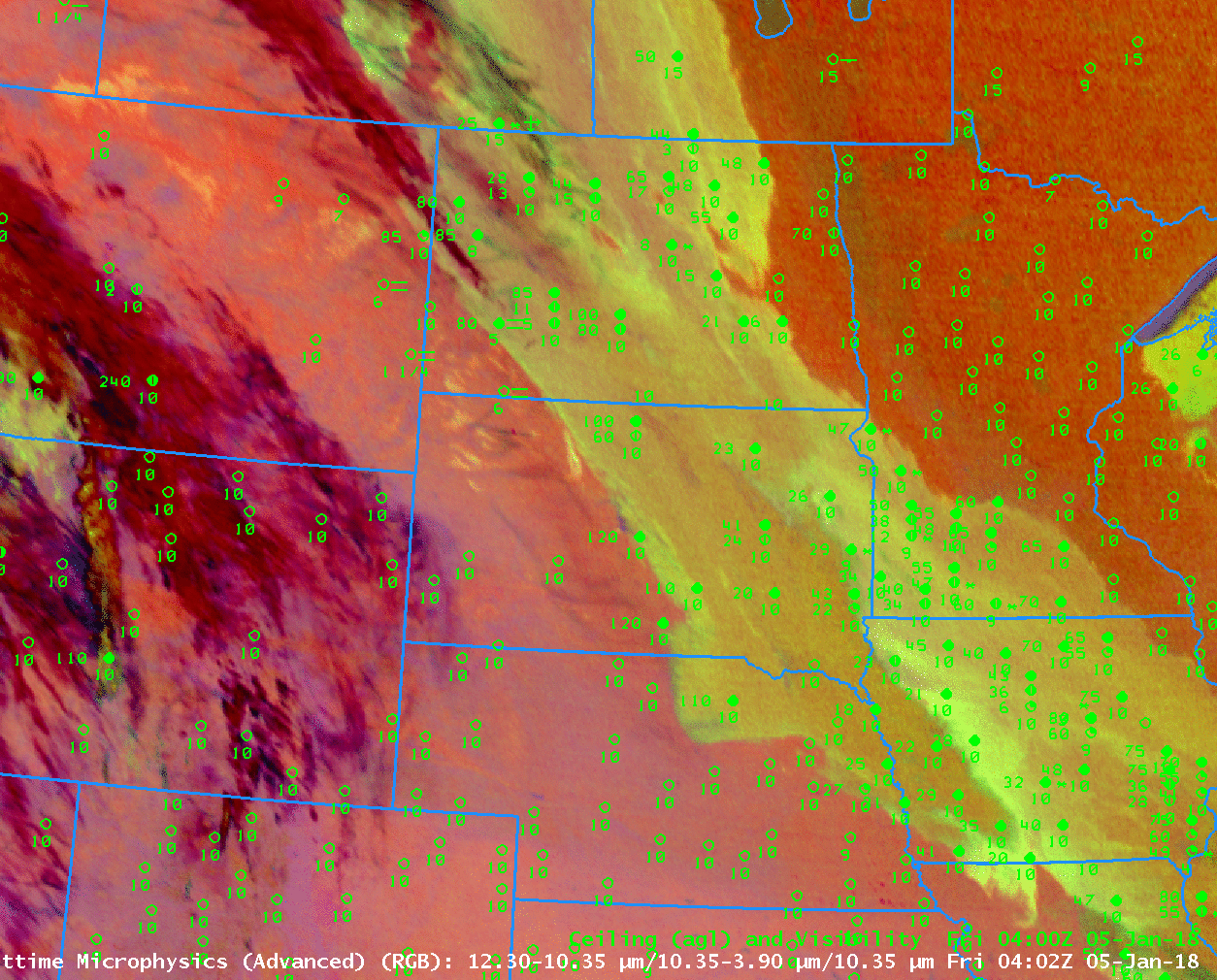
Consider the Brightness Temperature Difference shown below. The 10.3 µm – 3.9 µm product is typically used to identify stratus and radiation fog, and it does detect those low clouds over North Dakota, and over Kansas, Missouri and southern Iowa, and over Ontario.  However, the dense clouds associated with the storm over much of Minnesota and Wisconsin meant that this brightness temperature difference field, and also the NightTime Microphysics Red Green Blue Product (which is sometimes used to detect fog), could not ‘see’ the fog over the upper midwest.

Know the limitations, strengths and weaknesses of your products as you use them!  On 22 January, High Clouds underscored limitations in the Brightness Temperature Difference product, and in the NightTime Microphysics product that relies on the Brightness Tempearature Difference product for fog detection.  That limitation meant the product was not useful in identifying IFR conditions in parts of the Upper Midwest.

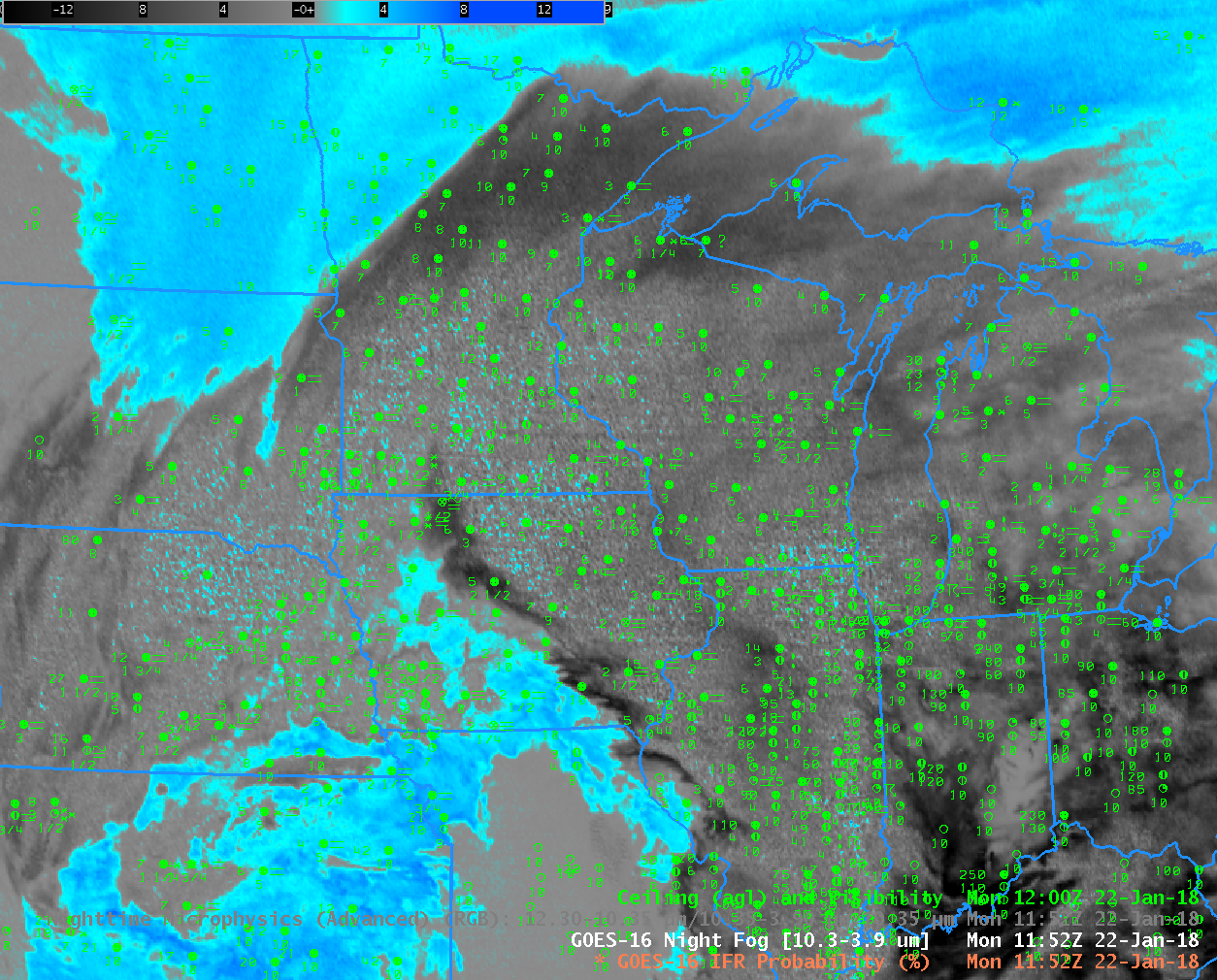
GOES-16 “Night Fog” Brightness Temperature Difference (10.3 µm – 3.9 µm) at 1152 UTC on 22 January 2018. Surface reports of ceilings and visibilities at 1200 UTC are also plotted (Click to enlarge)

Dense Fog Advisories over the Plains

Dense Fog Advisories were issued over parts of the central and northern Plains states on Friday January 5. For example, from the North Platte Office (similar warnings were issued by Billings, Rapid City and Bismark offices):

URGENT – WEATHER MESSAGE
National Weather Service North Platte NE
634 AM CST Fri Jan 5 2018

…Areas of dense fog likely this morning…

.Areas of fog reducing visibilities below one quarter mile at
times will be likely from parts of southwest into the central
Nebraska Sandhills this morning. With the fog occurring where
temperatures are below freezing, some slick spots may develop on
area roads and sidewalks as well.

NEZ025-026-037-038-059-071-051800-
/O.NEW.KLBF.FG.Y.0001.180105T1234Z-180105T1800Z/
Thomas-Blaine-Logan-Custer-Lincoln-Frontier-
Including the cities of Thedford, Halsey, Dunning, Purdum,
Brewster, Stapleton, Broken Bow, North Platte, Curtis, Eustis,
and Maywood
634 AM CST Fri Jan 5 2018

…DENSE FOG ADVISORY IN EFFECT UNTIL NOON CST TODAY…

The National Weather Service in North Platte has issued a Dense
Fog Advisory, which is in effect until noon CST today.

* Visibilities…as low as one quarter mile or less at times.

* Timing…Through the morning hours with visibilities improving
after noon CST.

* Impacts…Hazardous driving conditions due to low visibility.
Fog may freeze on area roads and walkways as well.

PRECAUTIONARY/PREPAREDNESS ACTIONS…

A Dense Fog Advisory means visibilities will frequently be
reduced to less than one quarter mile. If driving, slow down, use
your headlights, and leave plenty of distance ahead of you.

&&

$$

JWS

GOES-16 IFR Probability fields captured the development of these regions of dense fog. The animation from 0400-1200 UTC on 5 January is below. Highest values of IFR Probability are consistent in the areas where IFR Conditions are developing and where Dense Fog Advisories were issued.

GOES-16 IFR Probability, 0402 – 1207 UTC on 5 January 2018 (Click to animate)

Note that IFR Probability fields are fairly high over Iowa and the eastern Dakotas, regions where mid-level stratus was widespread but where IFR observations did not occur. On this day, Low IFR Probability fields better screened out this region of mid-level stratus. The toggle below compares IFR Probability and Low IFR Probability on 0957 UTC. The region where dense fog advisories were issued shows high values in both fields. The stratus deck over Iowa and the eastern Dakotas shows much smaller values of Low IFR Probability.

GOES-16 also has a ‘Fog Product’ brightness temperature difference (10.3 – 3.9) that has historically been used to detect low clouds. However, when cirrus clouds are present, as on 5 January, the efficacy of this product in fog detection is affected. Although fog and stratus detection is identifiable underneath the moving cirrus (the same is true in the Advanced NightTime Microphysics RGB product below), identifying the low cloud as stratus or fog from satellite data is a challenge because a consistent color married to IFR Probability does not exist.

GOES-16 ‘Fog Product’ Brightness Temperature Difference (10.3 µm – 3.9 µm), 0402 – 1207 UTC, 5 January 2017 (Click to animate)

GOES-16 Advanced Nighttime Microphysics RGB, 0402-1207 UTC on 5 January 2018 (Click to animate)

GOES-16 IFR Probability fields maintain a consistent look from night to day. Both the (10.3 µm – 3.9 µm) Brightness Temperature Difference field and the Advanced Nighttime Microphysics RGB (that uses the ‘Fog Product’ BTD) will change because the increase in reflected solar radiation at 3.9 µm will change the sign of the Brightness Temperature Difference field. There is a Daytime Day/Snow/Fog RGB Product in AWIPS, and the toggle below from 1612 UTC on 5 January compares IFR Probability and the Day/Snow/Fog RGB. As with the nighttime products, the presence of high (or mid-level) clouds makes it difficult to use the RGB alone to identify regions of fog/low stratus. In contrast, the IFR Probability field continues to correctly identify where the obstructions to visibility exist.