Monthly Archives: March 2021

IFR Conditions over southwest Alaska

GOES-17 IFR Probability fields, 1120 – 2110 UTC on 7 March 2020 (Click to enlarge)

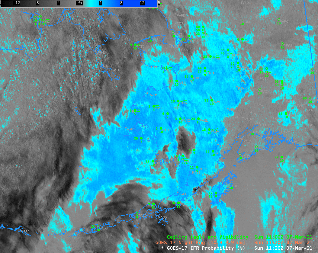
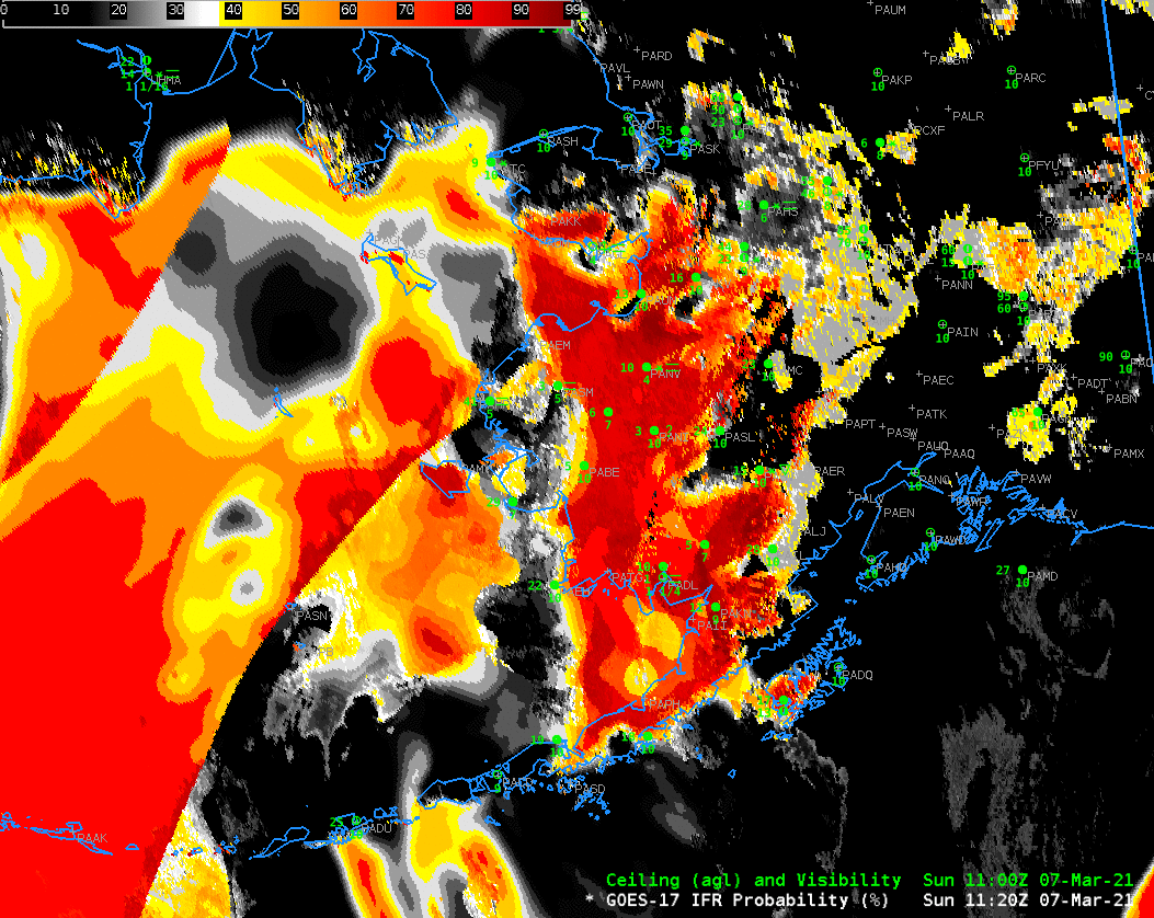
GOES-17 IFR Probability fields over southwestern Alaska and the Aleutians, shown above, characterize several areas of likely IFR conditions on 7 March. One region is over the Bering Sea, north of the Aleutians. This is a region where multiple cloud layers prevent the satellite from viewing low clouds. However, the Rapid Refresh model simulation there does show saturation at low levels; large values of IFR Probability are the result. When model fields control the IFR Probability values, there is little pixel-to-pixel variability and field has a uniform look. This example also shows values from two different models — the Alaska version of the Rapid Refresh (over most of the domain) and the GFS model over parts of Asia.

A second region of high IFR Probabilities is over land in southwest Alaska. There, an absence of high clouds means that satellite detection of low clouds occurs. There is good agreement between IFR Probability fields and observations of ceilings and visibility. For example, note how IFR Probability decreases around PAUN (Unalakeet) as the visibility improves and ceilings lift.

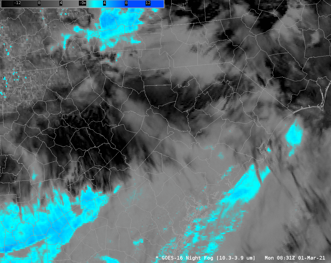
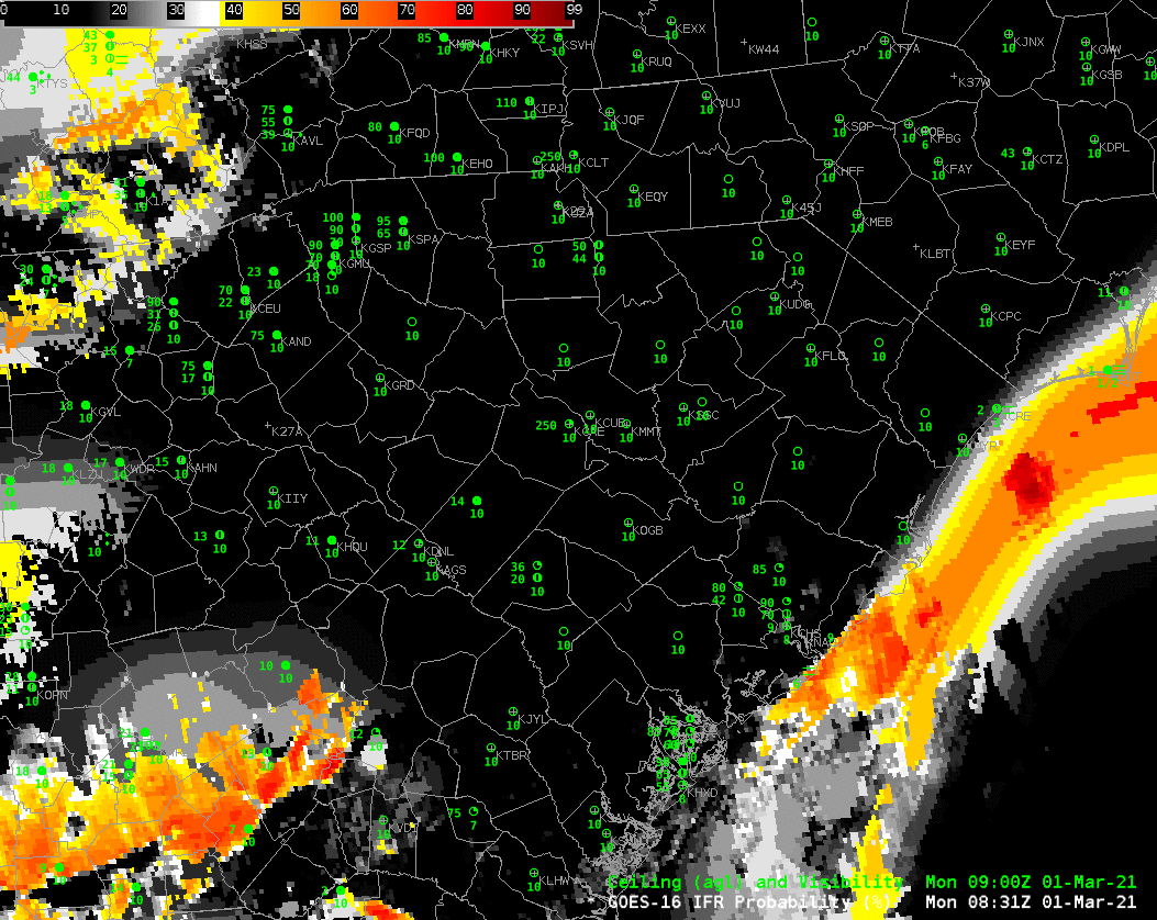
The toggle between the Night Fog Brightness temperature difference and IFR Probability field at 1210 UTC, below, reveals differences as well. The Brightness Temperature Difference field shows uniformity (except for a path of high clouds centered on Dillingham). IFR Probability fields show that the low clouds and reduced visibilities are not so widespread: note the conditions near McGrath and Sleetmute — IFR Probabilities are low, and IFR conditions are not present.

GOES-17 IFR Probability fields and Night Fog Brightness Temperature Difference (10.3 µm – 3.9 µm), 1220 UTC on 7 March 2021 (Click to enlarge)

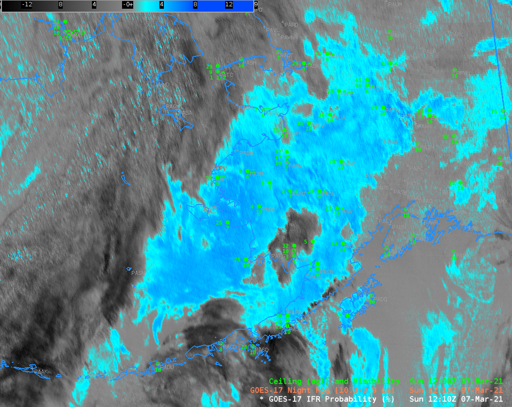
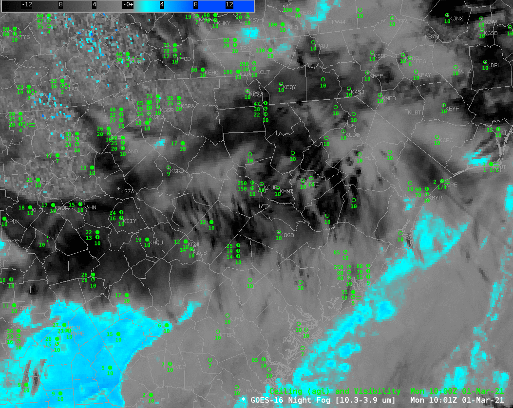
The animation of Night Fog Brightness temperature below demonstrates challenges in using the field. When high clouds overspread a region, the low cloud signal is lost; perhaps because the fog lifts, and perhaps not. The signal is also lost as the sun rises: the emissivity differences that drive the difference field at night are overwhelmed by solar reflectance as the sun rises.

GOES-17 Night Fog Brightness Temperature Difference (10.3 µm – 3.9 µm) field, 1220 – 1830 UTC on 7 March 2021 (Click to enlarge)

Coastal fog under clouds in South Carolina

GOES-16 Brightness Temperature Difference (10.3 µm – 3.9 µm), 0831 – 1331 UTC 1 March 2021 (Click to enlarge)

GOES-16 Night Fog Brightness Temperature Difference (BTD) fields (10.3 µm – 3.9 µm), above, show different cloud types in and around South Carolina before and through sunrise on 1 March 2021. Before sunrises, low clouds — stratus and fog — are characterized by blue/cyan/aqua colors in this enhancement. The positive brightness temperature difference arises because of emissivity differences in small cloud droplets for shortwave (3.9 µm) and longwave (10.3 µm) infrared radiation. Negative brightness temperature differences occur for higher clouds.

The presence of high clouds interferes with the satellite’s ability to view low clouds. Although one can infer a low cloud’s presence from an animation (and the assumption that the cloud doesn’t substantively change when a high cloud overspreads it), it’s a bit more difficult to extrapolate the cloud base from the cloud top behavior. In other words: Are the low clouds highlighted actually fog? Note also how the BTD enhancement changes as reflected solar radiation around sunrise starts to overwhelm any differences attributable to emissivity.

IFR Probability fields, shown below, combine the strength of satellite detection of low clouds with the strength model depiction of low-level saturation. IFR Probabilities will be quite high where satellites detect low clouds, and where Rapid Refresh model simulations show near-surface saturation. But if high clouds are in the way, IFR Probabilities can still be large if the Rapid Refresh model shows low-level saturation. This is occurring off the coasts of South and North Carolina. Note also: IFR Probability fields aren’t changing radically as the sun rises.

GOES-16 IFR Probability, along with surface observations of ceilings and visibility, 0831 UTC – 1326 UTC 1 March 2021 (Click to enlarge)
Night Fog Brightness Temperature Difference, Night time microphysics RGB, GOES-16 IFR Probability, 1001 UTC on 1 March 2021 (Click to enlarge)

The toggle above compares the Night Fog BTD with the Night time microphysics RGB (an RGB that takes as its green component the Night Fog BTD), and the GOES-16 IFR Probability fields at 1001 UTC on 1 March, shortly before sunrise. There is an obvious relationship between the RGB color and the regions of low clouds highlighted in the BTD by blue/cyan/aqua colors; the color of the RGB is tempered by the cloud temperature, however: the blue component of the RGB is the longwave infrared brightness temperature, and that is different over the ocean compared to over southwestern Georgia (for example). Note also how IFR Probability shows large values under the deep clouds over northwest South Carolina/western North Carolina.

Why is fog occurring offshore? Moist air over South Carolina is moving over relatively cool shelf waters, and cooled to its dewpoint; advection fog is the result. The toggle below shows surface dewpoints in the low 60s over coastal South Carolina. Sea-surface temperatures, shown at bottom from VIIRS at 0700 UTC and GOES-16 at 1300 UTC, show cool shelf waters with surface temperatures in the 50s (F).

GOES-16 IFR Probability with surface observations of ceilings/observations and surface METARs, 1001 UTC on 1 March 2021 (Click to enlarge)
NOAA-20 ACSPO VIIRS Sea Surface Temperatures (0701 UTC) and GOES-16 SST Temperatures (1301 UTC), click to enlarge