Category Archives: AFD

Dense Fog in southern Louisiana

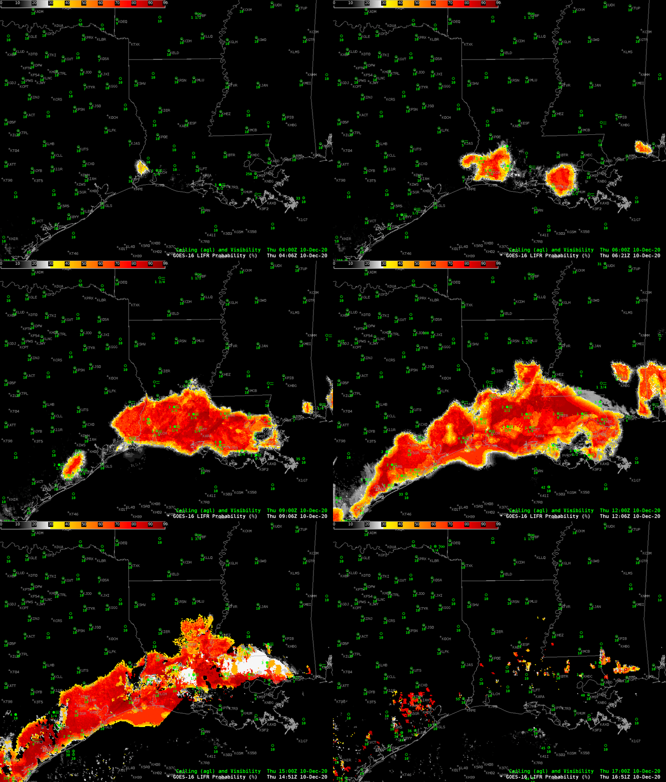
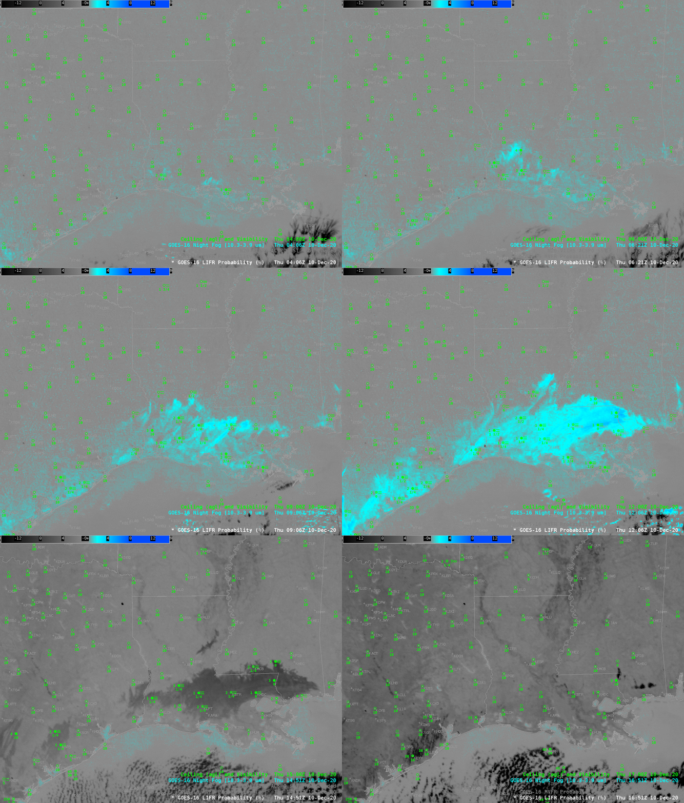
GOES-16 Low IFR Probability fields, 0406 – 1651 UTC, 10 December 2020 , along with surface observations of ceilings and visibility (Click to enlarge)

High Pressure (link), cold air, and proximity to warm Sea Surface Temperatures (image here, ACSPO SSTs from the Direct Broadcast Antenna at CIMSS) meant dense fog over southwestern Louisiana. The animation above shows Probabilty of Low IFR Conditions from 0400 UTC through sunrise. Low IFR Probability fields originate near Lake Charles and Franklin before consolidating into one large field over southern Louisiana. Surface observations of ceilings and visibilities also indicate dense fog.

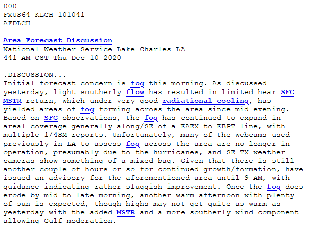
An after-effect of the landfall of Hurricanes is the destruction of webcams that can be used to monitor fog, as noted in the Area Forecast Discussion from WFO Lake Charles, below, from 441 AM CST on 10 December. IFR Probability products in AWIPS combine model predictions of low-level saturation and satellite observations of low cloud to mitigate this loss of information. Regions where low IFR Probability values are high are likely regions that would have dense fog on webcams.
Night Fog Brightness Temperature difference (10.3 µm – 3.9 µm) fields, below, also show the region of stratus clouds. But this satellite-only product does not contain information on how dense the fog is underneath the cloud top (or even if the stratus cloud is also fog). The combination of model data and satellite data by IFR Probability products gives more information than satellite data alone.
GOES-16 Night Fog Brightness Temperature Difference (10.3 µm – 3.9 µm), 0406 – 1651 UTC on 10 December 2020 (Click to enlarge)

The suite of IFR Probability products includes a GOES-R Cloud Thickness field, shown below overlain on top of a Night Fog Brightness Temperature Difference field. Cloud Thickness is not computed in the 90-120 minutes surrounding sunrise, and the terminator is apparent in the image below, where the Night Fog Brightness Temperature Difference becomes apparent. The thickest cloud (nearly 400 m) is northwest of Lake Ponchartrain. That is where the fog should dissipate last, perhaps.
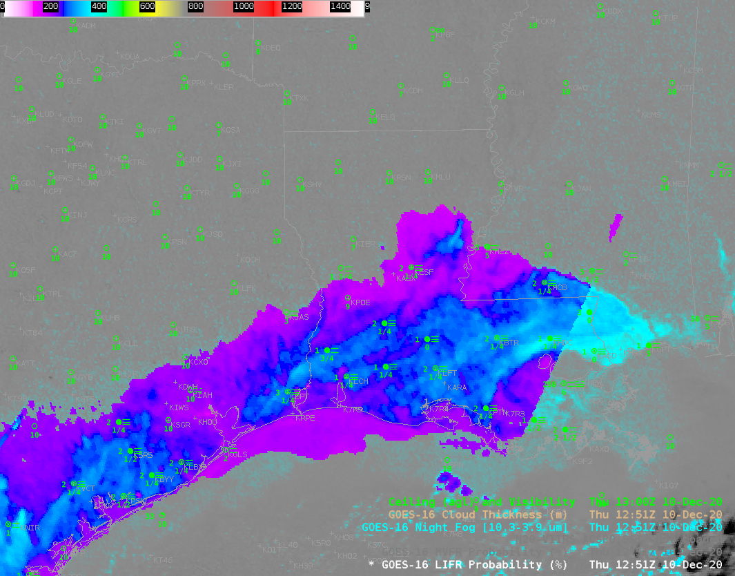
GOES-R Cloud Thickness field, 1251 UTC, displayed on top of the Night Fog Brightness Temperature Difference field (10.3 µm – 3.9 µm) from the same time (Click to enlarge)

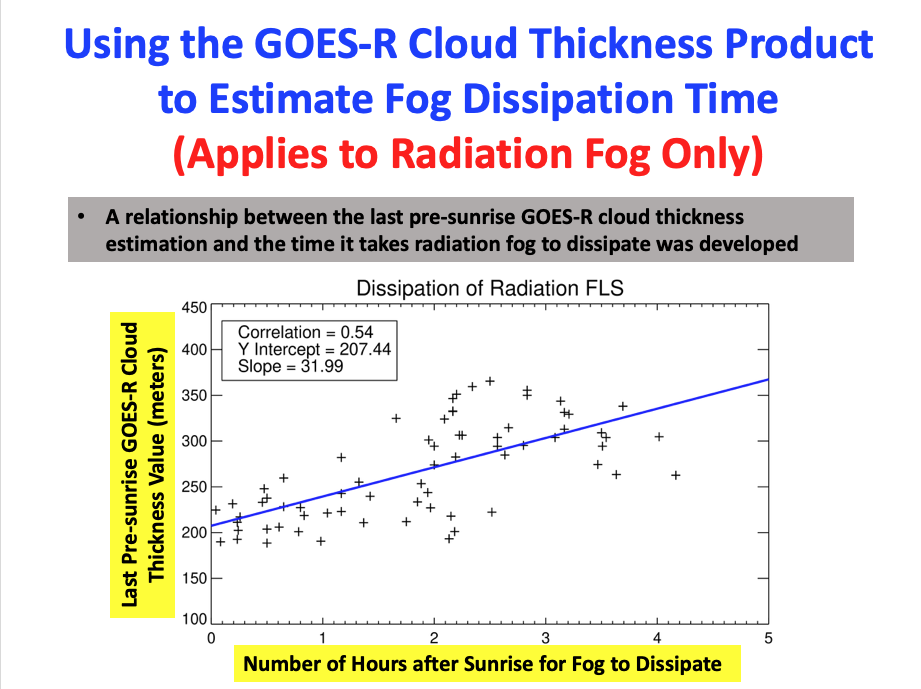
The scatterplot below can be used to estimate when radiation fog might dissipate. It relates the last pre-sunrise observation of GOES-R Cloud Thickness, as shown above, to the number of hours until burn-off. A value of almost 400 m suggests a burnoff nearly four hours after the image above: 1651 UTC. The Thickness field also suggests fog dissipation will be more rapid over southwestern Louisiana than over regions near Lake Ponchartrain. Animations of the Night Fog Brightness Temperature, above, and the visible imagery, below, show that the estimate was a good one on this day.
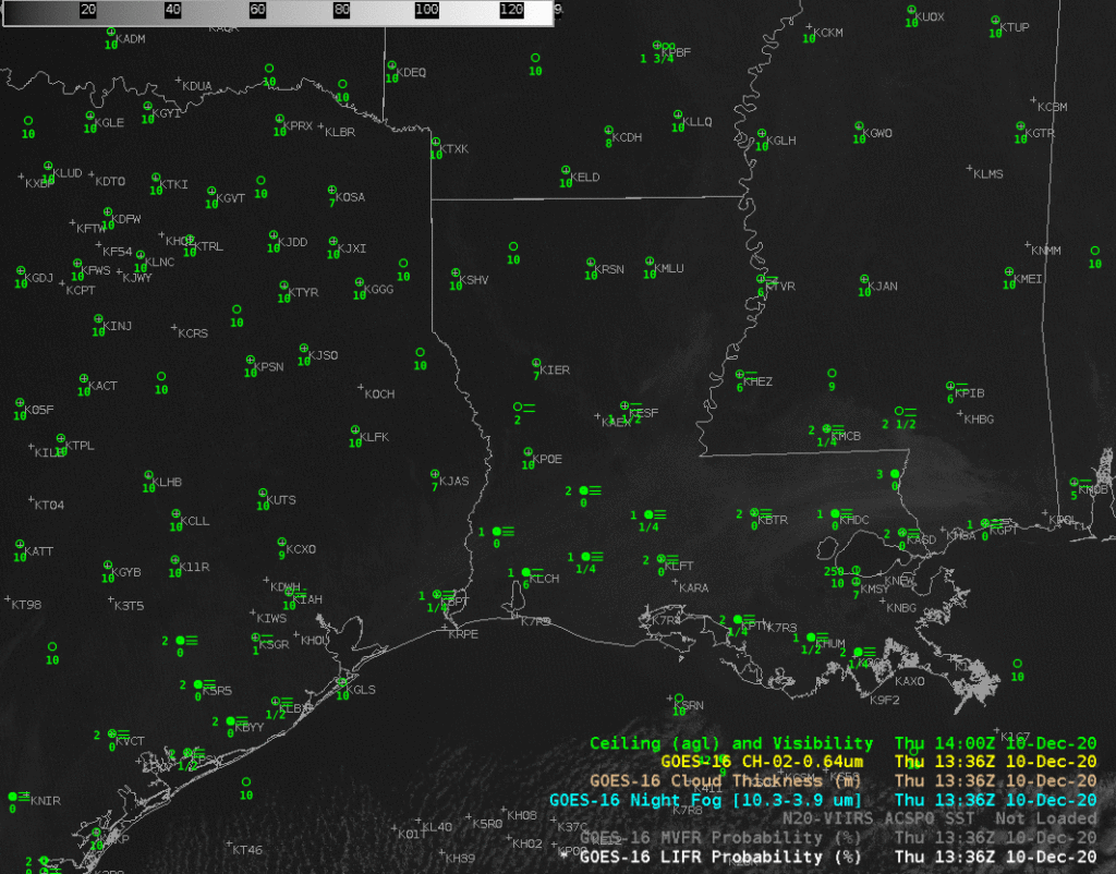
GOES-16 Band 2 (0.64 µm) visible imagery, 1336 – 1651 UTC on 10 December 2020 (Click to enlarge)

The IFR Probability products include Low IFR Probability, shown above, IFR Probability, and Marginal VFR (MVFR) Probability, in addition to Cloud Thickness. The toggle below, from 0906 UTC, shows that MVFR Probability and Low IFR Probability fields were co-located. As expected, probability of MVFR conditions are greater than probabilities of Low IFR conditions.
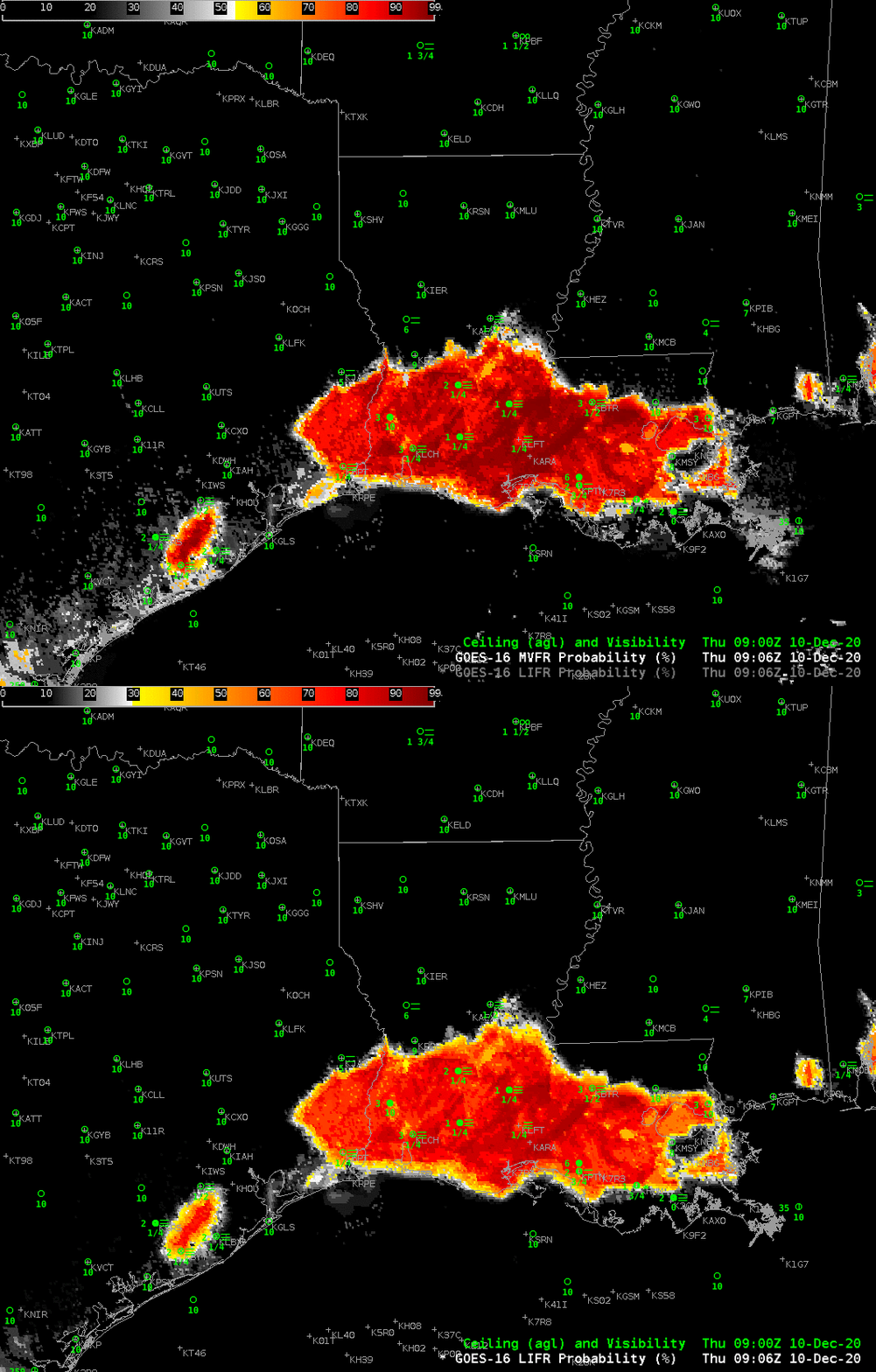
GOES-R Low IFR and MVFR Probability, 0906 UTC on 10 December 2020 (Click to enlarge)

Added: Lake Charles WFO also tweeted out this excellent image of a Fog Bow as the fog dissipated!

More fog over South Carolina

Dense fog redeveloped over South Carolina overnight on 3-4 December 2014, and as noted in the Forecast Discussion below, its character was just a bit different than on the previous night.

000
FXUS62 KCHS 040239
AFDCHS

AREA FORECAST DISCUSSION
NATIONAL WEATHER SERVICE CHARLESTON SC
939 PM EST WED DEC 3 2014

.SYNOPSIS…
UNDER A WEAKENING WEDGE OF HIGH PRESSURE…FOG WILL PERSIST TONIGHT.
ANOTHER AREA OF HIGH PRESSURE WILL BUILD FROM THE NORTH THURSDAY THROUGH
FRIDAY. A WARM FRONT WILL THEN LIFT ACROSS THE AREA ON SATURDAY…
BEFORE A COLD FRONT MOVES THROUGH SATURDAY NIGHT. AN INLAND WEDGE
OF HIGH PRESSURE WILL BECOME ESTABLISHED SUNDAY AND MONDAY…FOLLOWED
BY THE PASSAGE OF ANOTHER COLD FRONT MONDAY NIGHT. HIGH PRESSURE
WILL THEN PREVAIL INTO THE MIDDLE OF NEXT WEEK.

&&

.NEAR TERM /UNTIL 6 AM THURSDAY MORNING/…
WHILE THE SCENARIO IS QUITE DIFFERENT FOR FOG TONIGHT COMPARED TO
LAST NIGHT…DESPITE PLENTY OF CIRRIFORM CLOUDS /SOME OF WHICH ARE
OPAQUE/
…WE ARE STILL GETTING AREAS OF FOG TO FORM. SOME OF THE
FOG IS ALREADY DENSE…ESPECIALLY IN THE CHARLESTON QUAD COUNTY
AREA AND ALONG OUR COASTAL ZONES SOUTH INTO MCINTOSH. THIS IS A
MIX OF STRATUS BUILD-DOWN AND ADVECTIVE FOG FROM OFF THE ATLANTIC
.
SO WE LOOK FOR A FURTHER EXPANSION OF THE FOG INLAND TO THE WEST
OF I-95 THROUGH THE NIGHT. DENSE FOG ADVISORIES WILL THEREFORE
REMAIN IN EFFECT.

IFRProb_04Dec2014anim

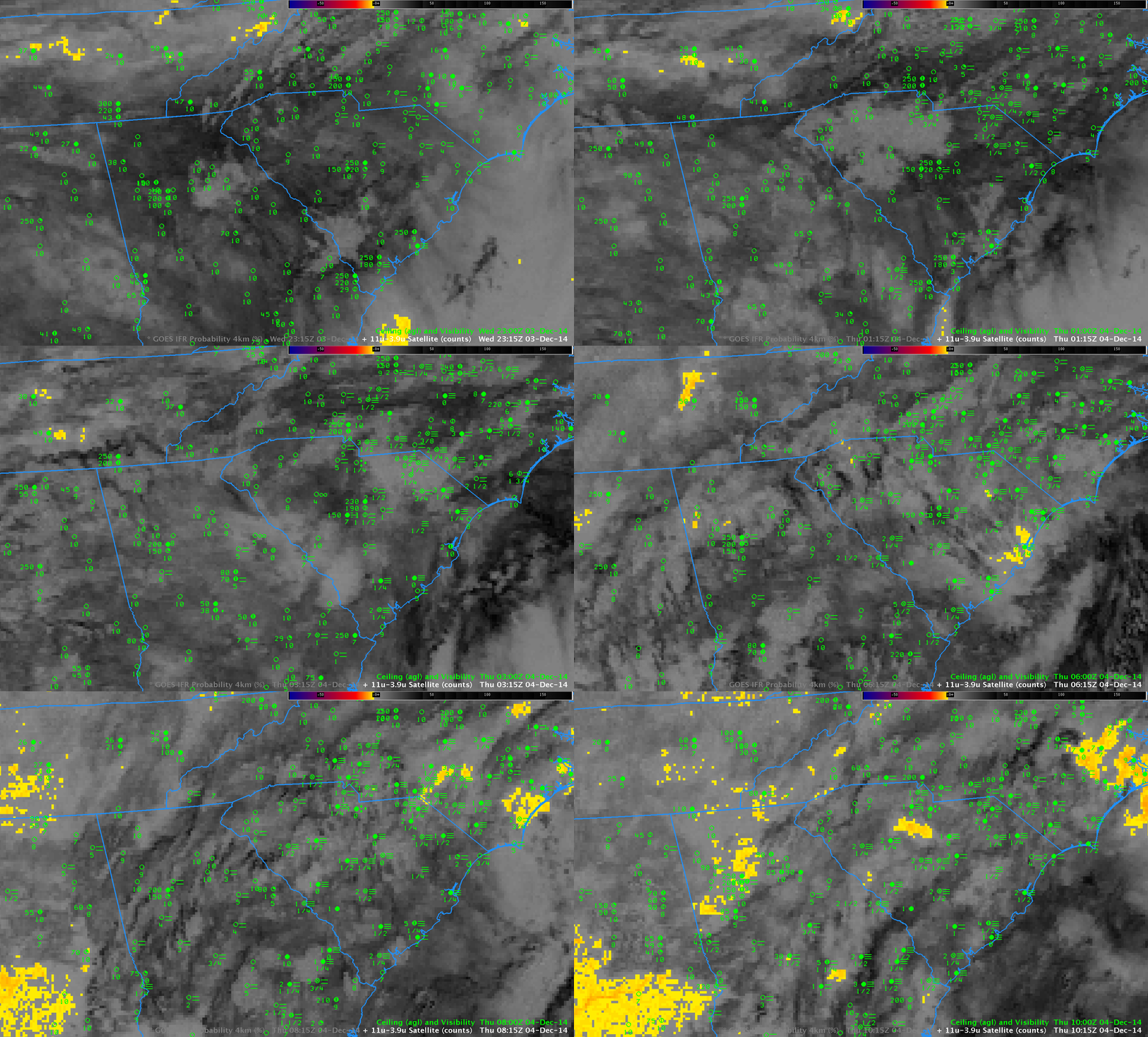
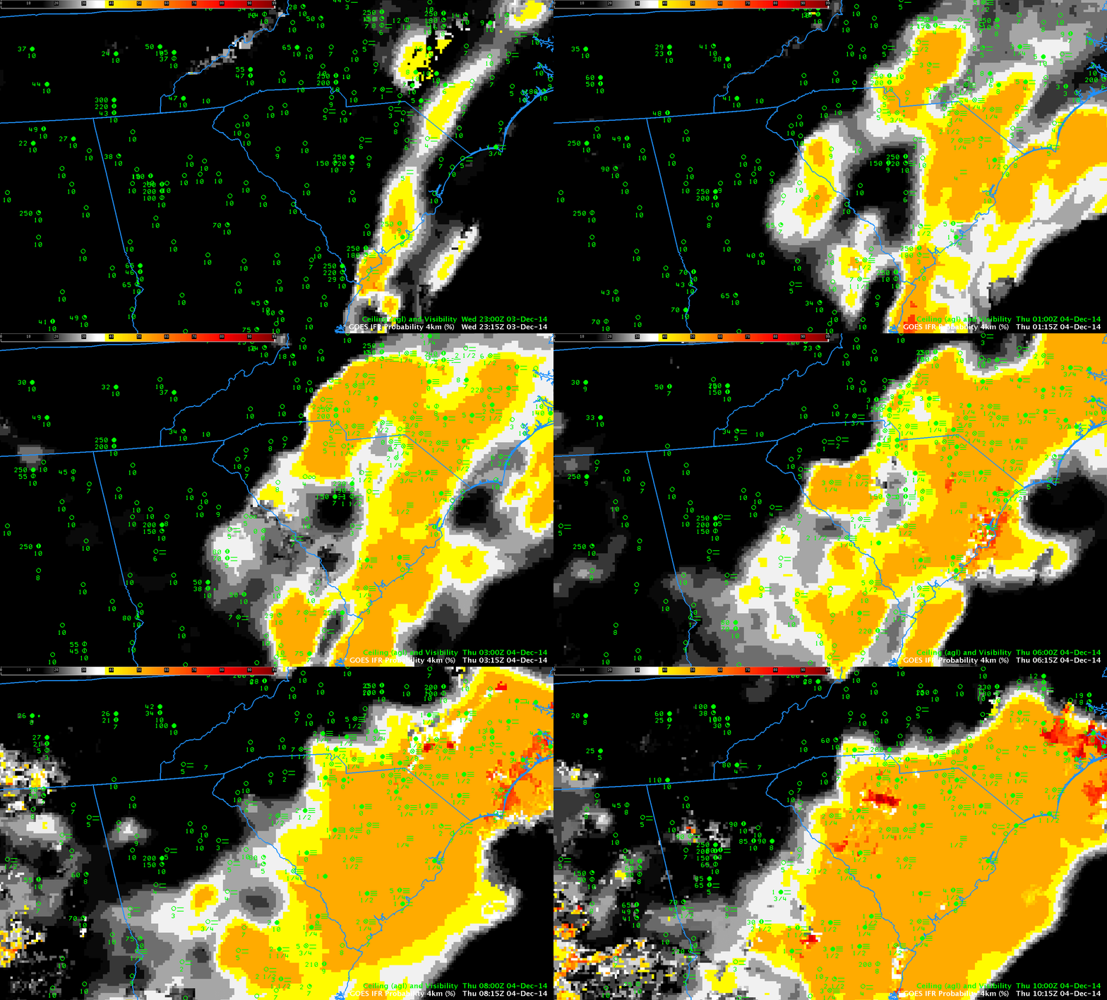
GOES-based GOES-R IFR Probabilities, hourly from 2315 UTC 3 December through 1015 UTC on 4 December as well as observations of ceilings (AGL) and visibilities (Click to enlarge)

GOES-R IFR Probabilities, above, (click here for an animation with a faster dwell rate) once again capably outlined the region of IFR conditions over South Carolina. Probabilities are lower when Satellite data cannot be used as a predictor, as when cirrus clouds prevent the satellite from viewing water-based clouds closer to the surface. In such cases when only Rapid Refresh model data can be used as Fog Predictors, the fields take on a flatter, less pixelated character as above. There are a few regions where breaks in the cirrus cloud allow Satellite predictors to be incorporated in the IFR Probability fields, for example along the South Carolina coast at 0600 UTC. When high clouds are present, interpret the magnitude of the IFR Probability in a different way than when high clouds are absent. An IFR Probability of 55% in a region of cirrus clouds has a different meaning than an IFR Probability of 55% in a region of only low clouds.

Because of Cirrus clouds, the brightness temperature difference fields gave almost no information about the presence of low clouds. See the animation below (a loop with a faster dwell rate is here).

BTD_GOES13_4DEC2014anim

GOES-13 Brightness Temperature Difference Fields (10.7µm – 3.9µm), hourly from 2315 UTC 3 December through 1015 UTC on 4 December, as well as observations of ceilings (AGL) and visibilities (Click to enlarge)

Dense Fog over South Carolina

Dense fog devloped over South Carolina overnight, in an event that was well-anticipated: From the Charleston, SC, National Weather Service Office AFD (emphasis added):

AREA FORECAST DISCUSSION
NATIONAL WEATHER SERVICE CHARLESTON SC
648 PM EST TUE DEC 2 2014

.SYNOPSIS…
WEAK HIGH PRESSURE WILL PERSIST THROUGH WEDNESDAY. A COLD FRONT
WILL ADVANCE SOUTH THROUGH THE AREA THURSDAY…THEN HIGH PRESSURE
WILL BUILD FROM THE NORTH AND WILL PREVAIL THROUGH FRIDAY. LOW
PRESSURE WILL TRACK THROUGH OR JUST NORTH OF THE REGION SATURDAY…
FOLLOWED BY COLD FRONTS SATURDAY NIGHT AND AGAIN LATE MONDAY.

&&

.NEAR TERM /UNTIL 6 AM WEDNESDAY MORNING/…
A FEW LINGERING STRAY SHOWERS WEST OF I-95 WILL DISSIPATE THIS
EVENING WITH THE ONSET OF NOCTURNAL COOLING AND STABILIZATION.

OUR MAIN FOCUS FOR TONIGHT IS IN REGARDS TO FOG AND THE BUILD DOWN
OF STRATUS
…SOME OF WHICH COULD BE DENSE. THE HIGH PRESSURE WEDGE
WILL REMAIN ANCHORED OVER THE INLAND PARTS OF THE SE AS IT
PROGRESSES A LITTLE SOUTHWARD THROUGH THE NIGHT…WITH A WEAK
COASTAL TROUGH OFFSHORE. A STRENGTHENING NOCTURNAL INVERSION WILL
DEVELOP AND TRAP ABUNDANT MOISTURE WITHIN THE PLANETARY BOUNDARY
LAYER UNDERNEATH. THIS WILL LEAD TO THE DEVELOPMENT AND SPREADING
OUT OF FOG AND STRATUS ENCOMPASSING MOST IF NOT ALL OF THE CWFA
DURING THE LATE NIGHT HOURS. BUT ALREADY WE/RE SEEING A FOG BANK
WITH IT/S ORIGINS NORTH OF THE SANTEE RIVER THIS AFTERNOON IS
PROGRESSING SOUTH/SW AND STARTING TO SPREAD A LITTLE INLAND. THIS
IS CLEARLY DEPICTED BY THE 11-3.9 MICRON SATELLITE IMAGERY AS WELL
AS COASTAL METAR SITES. THE COMBINATION OF THE MARINE INDUCED FOG
AND STRATUS WILL COMBINE WITH RADIATION FOG THAT FORMS OVER INLAND
SECTIONS TO RESULT IN AREAS OF FOG ACROSS THE FORECAST ZONES.
THE
WORST CONDITIONS WILL BE OVER CHARLESTON COUNTY THIS
EVENING…SPREADING INTO OTHER COASTAL SC ZONES LATER THIS EVENING
AND INTO THE GA COASTAL ZONES BY MIDNIGHT OR SO. INLAND THE BULK
OF THE GREATER FOG/STRATUS COVERAGE WILL WAIT UNTIL WE REACH OUR
CROSS-OVER TEMPS BY 2-3 AM. DENSE FOG ADVISORIES ARE CERTAINLY
POSSIBLE. ANY NEGATING FACTORS AGAINST THE WIDESPREAD DENSE FOG
WOULD BE THE RELATIVELY WARM GROUNDS. BUT GIVEN FOG STABILITY
INDICES IN THE TEENS AND LOWER 20S…MOST PLACES REACHING THEIR
CROSS-OVER TEMPS OF 55-60 AND SOME MARINE FOG WE/D LEAN MORE
TOWARD DENSE FOG BECOMING A CONCERN…THAN NOT.

GOESR_IFRProb_03Dec2014loop

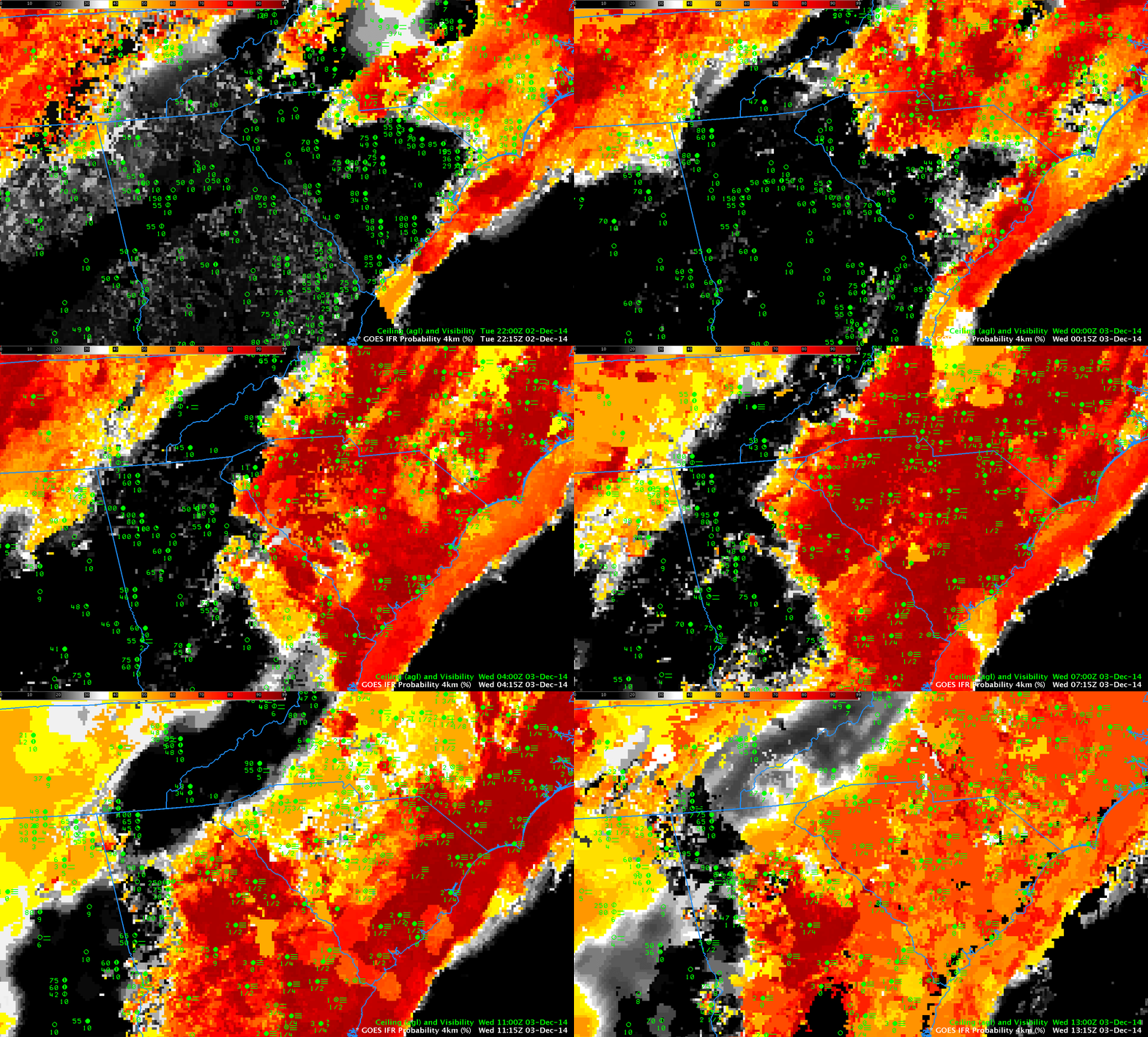
GOES-based GOES-R IFR Probabilities, hourly from 2215 UTC 2 December through 1315 UTC on 3 December as well as observations of ceilings (AGL) and visibilities (Click to enlarge)

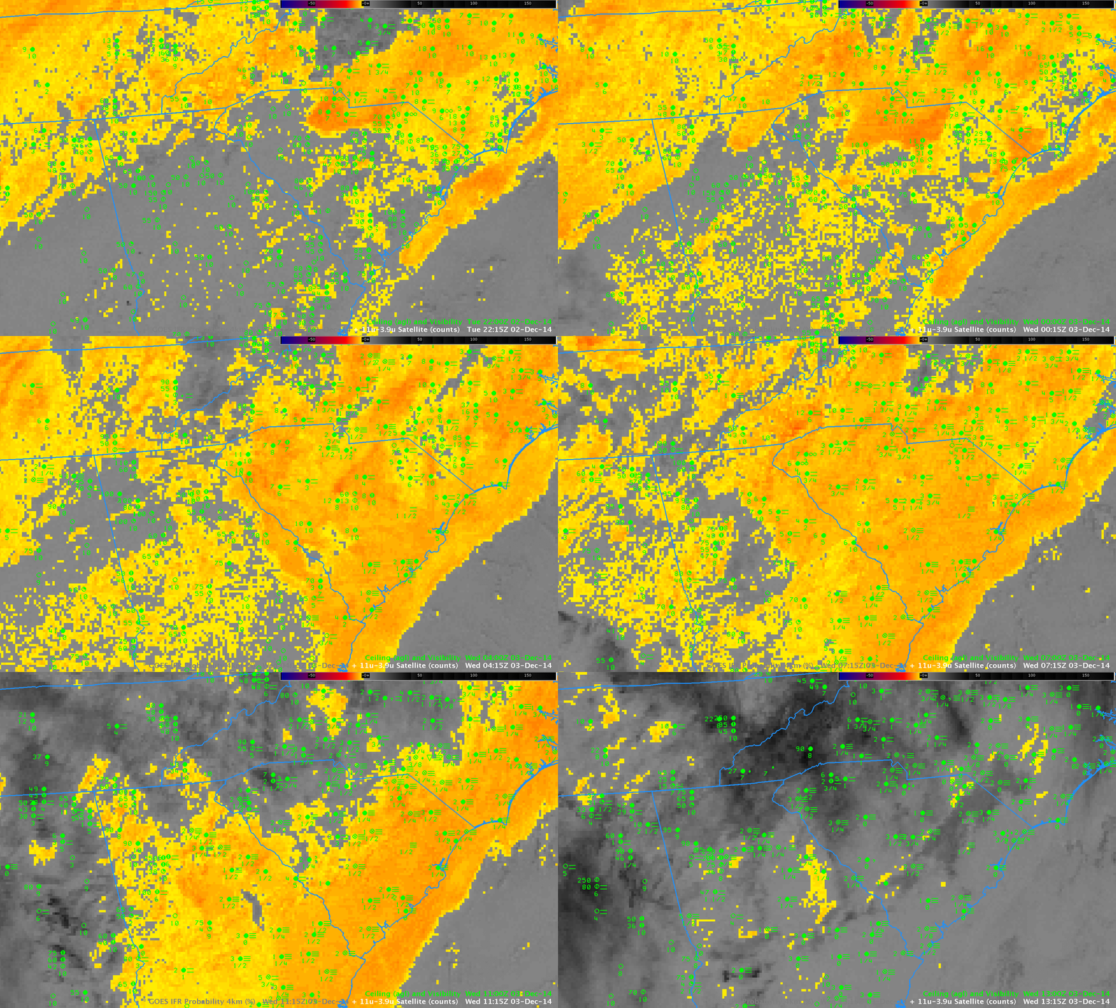
The GOES-R IFR Probability fields, shown at hourly intervals above, nicely capture the spread of the extensive fog as the expanding marine fog bank joins up with the developing radiation fog over northwestern South Carolina. (A loop with a shorter dwell rate is here). GOES-13 Brightness Temperature Difference Fields are shown below. (A loop with a shorter dwell rate is here). Brightness Temperature Difference is the traditional method of detecting fog and low stratus, and it is referenced in the AFD above. However, the method cannot operate in regions with high cirrus (such as over Tennessee and northwest South Carolina after 0900 UTC); the brightness temperature difference signal flips sign as the sun rises (as at 1315 UTC in the animation below); the method cannot distinguish between elevated stratus and visibility-restricting fog.

GOES13BTD_03Dec2014loop

GOES-13 Brightness Temperature Difference Fields (10.7µm – 3.9µm), hourly from 2215 UTC 2 December through 1315 UTC on 3 December, as well as observations of ceilings (AGL) and visibilities (Click to enlarge)

In comparing the two animations, note how the Brightness Temperature Difference field, for example, has strong returns around 0215-0315 UTC over central South Carolina in regions where widespread IFR conditions do not yet exist. In these regions, the Rapid Refresh model data used as a predictor in the GOES-R IFR Probability is not yet showing saturation, so IFR Probabilities aren’t quite so high as they are along the coast. (Click here for a toggle between the GOES-R IFR Probability and the Brightness Temperature Difference fields at 0215 UTC; a toggle at 0315 UTC is here). Note also in the toggles how the IFR Probability fields have little signal over Georgia despite the Brightness Temperature Difference field signal. This demonstrates the power of using fused data products: both the satellite and the model signal must be in accord for very high probabilities to occur.

Fog over Southeast New England

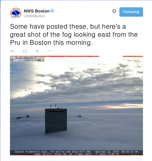
Fog overspread much of southern New England overnight on 11-12 November 2014.

BostonTweet7AM_12Nov2014

Downtown Boston, Fogbound, Wednesday Morning 12 Nov 2014 (Photo Credit: Blue Hill Observatory)

From the National Weather Service in Taunton, MA, late in the day on 11 November 2014:

000
WWUS81 KBOX 120001
SPSBOX

SPECIAL WEATHER STATEMENT
NATIONAL WEATHER SERVICE TAUNTON MA
701 PM EST TUE NOV 11 2014

CTZ002>004-MAZ002>024-026-NHZ011-012-015-RIZ001>008-120415-
HARTFORD CT-TOLLAND CT-WINDHAM CT-WESTERN FRANKLIN MA-
EASTERN FRANKLIN MA-NORTHERN WORCESTER MA-CENTRAL MIDDLESEX MA-
WESTERN ESSEX MA-EASTERN ESSEX MA-WESTERN HAMPSHIRE MA-
WESTERN HAMPDEN MA-EASTERN HAMPSHIRE MA-EASTERN HAMPDEN MA-
SOUTHERN WORCESTER MA-WESTERN NORFOLK MA-SOUTHEAST MIDDLESEX MA-
SUFFOLK MA-EASTERN NORFOLK MA-NORTHERN BRISTOL MA-
WESTERN PLYMOUTH MA-EASTERN PLYMOUTH MA-SOUTHERN BRISTOL MA-
SOUTHERN PLYMOUTH MA-BARNSTABLE MA-DUKES MA-NANTUCKET MA-
NORTHERN MIDDLESEX MA-CHESHIRE NH-EASTERN HILLSBOROUGH NH-
WESTERN AND CENTRAL HILLSBOROUGH NH-NORTHWEST PROVIDENCE RI-
SOUTHEAST PROVIDENCE RI-WESTERN KENT RI-EASTERN KENT RI-
BRISTOL RI-WASHINGTON RI-NEWPORT RI-BLOCK ISLAND RI-
INCLUDING THE CITIES OF…HARTFORD…WINDSOR LOCKS…UNION…
VERNON…PUTNAM…WILLIMANTIC…CHARLEMONT…GREENFIELD…
ORANGE…BARRE…FITCHBURG…FRAMINGHAM…LOWELL…LAWRENCE…
GLOUCESTER…CHESTERFIELD…BLANDFORD…AMHERST…NORTHAMPTON…
SPRINGFIELD…MILFORD…WORCESTER…FOXBORO…NORWOOD…
CAMBRIDGE…BOSTON…QUINCY…TAUNTON…BROCKTON…PLYMOUTH…
FALL RIVER…NEW BEDFORD…MATTAPOISETT…CHATHAM…FALMOUTH…
PROVINCETOWN…VINEYARD HAVEN…NANTUCKET…AYER…JAFFREY…
KEENE…MANCHESTER…NASHUA…PETERBOROUGH…WEARE…FOSTER…
SMITHFIELD…PROVIDENCE…WEST GREENWICH…WARWICK…BRISTOL…
NARRAGANSETT…WESTERLY…NEWPORT…BLOCK ISLAND
701 PM EST TUE NOV 11 2014

…PATCHY DENSE FOG POSSIBLE OVERNIGHT INTO WEDNESDAY MORNING…

A WARM AND MOIST AIRMASS BY NOVEMBER STANDARDS WAS OVER
CONNECTICUT… RHODE ISLAND…MASSACHUSETTS AND INTO NEW HAMPSHIRE
THIS EVENING. THIS COMBINED WITH LIGHT WINDS WILL RESULT IN PATCHY
DENSE FOG OVERNIGHT INTO WEDNESDAY MORNING. THERE IS SOME
UNCERTAINTY ON HOW WIDESPREAD THE FOG WILL BE. THUS A DENSE FOG
ADVISORY HAS NOT BEEN POSTED. HOWEVER AT LEAST SOME PATCHY DENSE
FOG IS LIKELY OVERNIGHT. THEREFORE MORNING COMMUTERS SHOULD PLAN
SOME EXTRA TIME TO REACH THEIR DESTINATION. IF FORECAST CONFIDENCE
ON WIDESPREAD DENSE FOG INCREASES LATER THIS EVENING A DENSE FOG
ADVISORY WILL BE ISSUED.

$$

NOCERA

Subsequently, the NWS in Taunton tweeted two times about the fog.

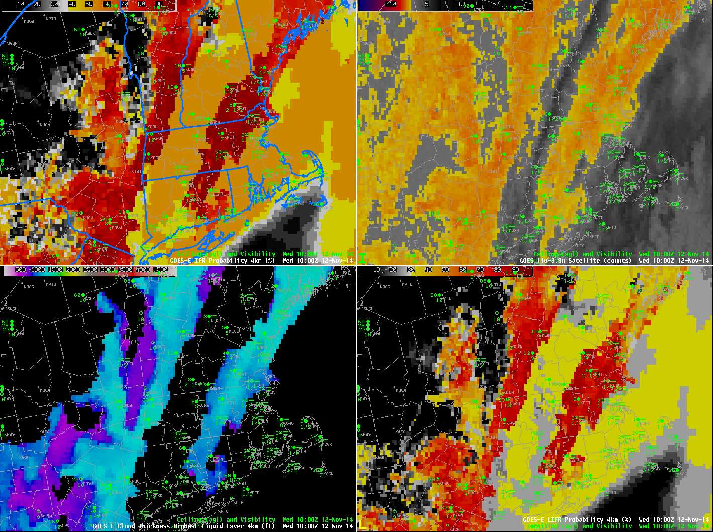
How well did the GOES-R IFR Probability Fields diagnose this fog event? Note the presence of high and mid-level clouds in the picture at top, from the morning of 12 November. Their signature should be in the IFR Probability fields as well, and that is the case.

GOES_IFR_PROB_20141112_0100-1215

GOES-R IFR Probabilities (Upper Left), GOES-East Brightness Temperature Difference (10.7 µm – 3.9 µm) (Upper Right), GOES-R Cloud Thickness (Lower Left) and GOES-R Low IFR Probability (Lower Right) (Click to animate)

In the animation above, the effect of high clouds is obvious on the IFR (and Low IFR) Probability fields: when mid-level or high clouds prevent satellite data from being used as a predictor in IFR Probability fields, then model data are the main predictors. Model data have coarse resolution relative to satellite data so the IFR Probability fields in those regions have a smoother look that is not at all pixelated. Note how a signal in of low clouds in the Brightness Temperature Difference Field (orange or yellow enhancement) nearly overlaps the more pixelated parts of the IFR and Low IFR Probability fields. Where cirrus/mid-level clouds are indicated in the brightness temperature difference fields, IFR and Low IFR Probability fields are smoother; these are also regions where the GOES-R Cloud Thickness (which field is of the thickness of the highest water-based cloud viewed by the satellite) is not computed because ice-based clouds are screening any satellite view of water-based clouds.

Note how southeastern Massachussetts in the animation above — under multiple cloud layers — has relatively small IFR and low IFR (LIFR) Probability values in a region where dense fog is reported. This arises because the model being used — the Rapid Refresh — to generate IFR Probability predictors is not saturating in the lower levels. It is important to remember that when satellite data are missing, only model data are used to generate GOES-R Fog/Low Stratus products. To rely on only the IFR Probability fields as an indication of the presence of fog is to believe the model simulation in that region is correct. Sometimes the model simulation is correct (this case, for example); in the present case, however, there were regions in southeastern Massachusetts where the model forecast did not accurately represent the observed conditions.

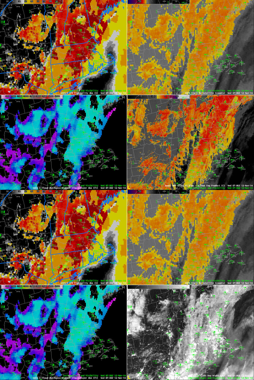
Suomi NPP overflew New England around 0700 UTC on 12 November, and the data collected are included in the image toggle below. Suomi NPP better resolves some of the smaller valleys in interior New England, and some of the sharp edges to the fields.

VIIRS_BTD_DNB__REF_20141112_0706

As above, but with a toggle between Suomi NPP VIIRS Day Night Band and Brightness Temperature Difference (11.45 µm – 3.74 µm) in the lower right. All data at ~0700 UTC 12 Nov (Click to enlarge)

Dense Fog Advisories over Missouri

CentralMissouri_14July2014loop

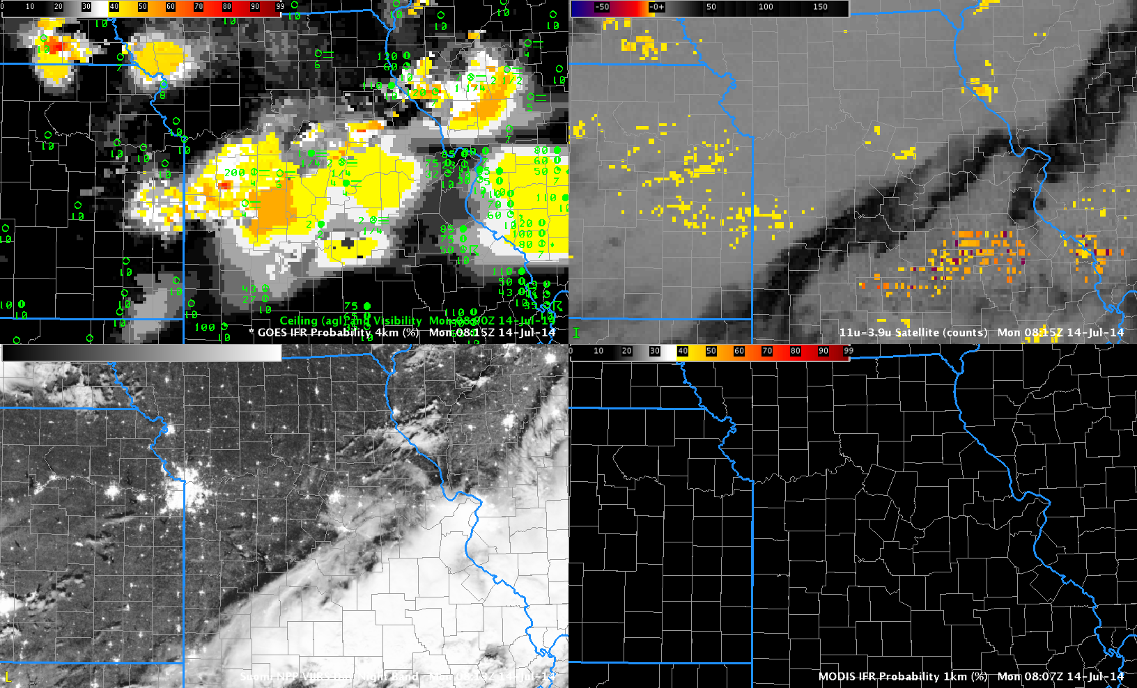
GOES-R IFR Probabilities (Upper Left), GOES-East Brightness Temperature Difference (10.7 µm – 3.9 µm) (Upper Right), Suomi/NPP Day/Night Band imagery (Lower Right), MODIS-based IFR Probabilitiy (Lower Left), times as indicated (Click to animate)

Moisture from departing late-day thunderstorms allowed for the development of dense fog over central Missouri overnight. The GOES-based IFR Probabilities, above, capture the low ceilings and reduced visibilities that developed. The traditional method of fog detection, the brightness temperature difference (BTD) between the 10.7 µm and 3.9 µm fields, was hampered by mid- and high-level clouds associated with the departing convection.

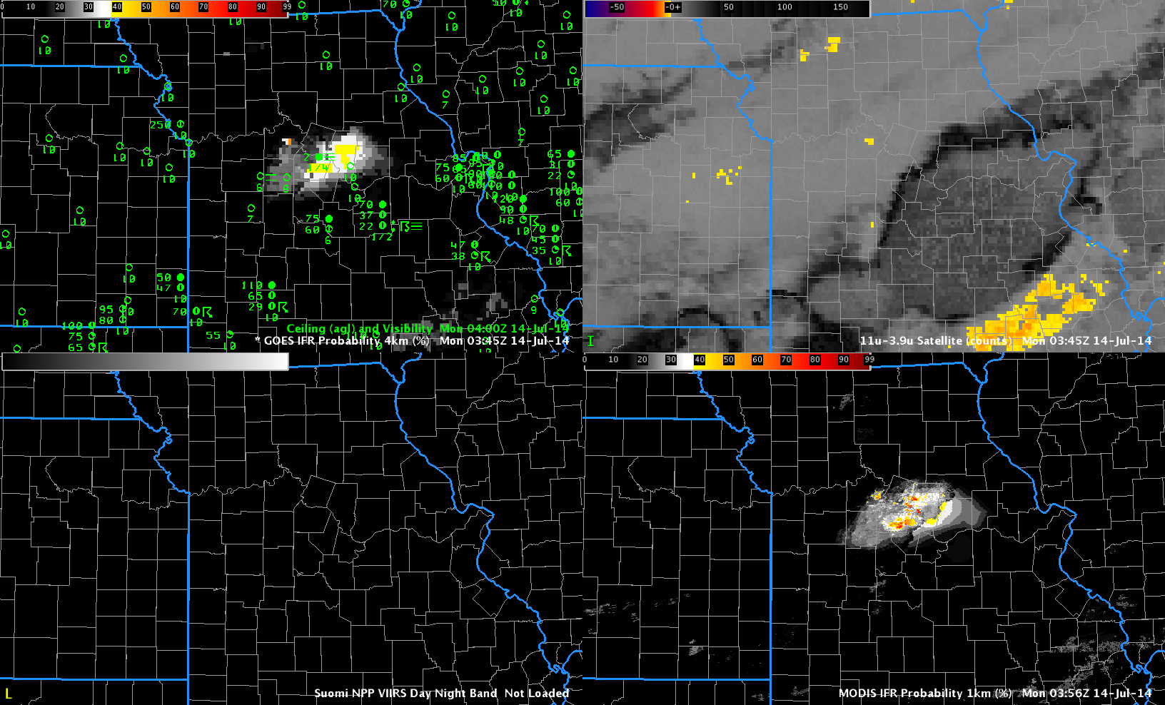
Polar-orbiting satellites such as Terra, Aqua and Suomi NPP can give high-resolution views of developing fog. In the present case, Terra overflew the region near 0400 UTC. The image below shows enhanced MODIS-based IFR Probabilities confined to central Missouri. An Aqua overpass at ~0800 UTC similarly gave a high spatial resolution view of the area. Of course, Terra and Aqua and Suomi NPP only give occasionaly snapshots. To see the ongoing development, temporal resolution as from GOES is key. But the polar orbiters can give an early alert if developing fog starts out at small scales that might be sub-pixel scale in GOES.

CentralMissouri_14July2014-18

As above, but at 0400 UTC 14 July 2014 (Click to enlarge)

From the National Weather Service in St. Louis:

URGENT – WEATHER MESSAGE
NATIONAL WEATHER SERVICE ST LOUIS MO
527 AM CDT MON JUL 14 2014

MOZ041-047>051-059-141400-
/O.NEW.KLSX.FG.Y.0002.140714T1027Z-140714T1400Z/
BOONE MO-CALLAWAY MO-COLE MO-GASCONADE MO-MONITEAU MO-
MONTGOMERY MO-OSAGE MO-
INCLUDING THE CITIES OF…COLUMBIA…JEFFERSON CITY
527 AM CDT MON JUL 14 2014

…DENSE FOG ADVISORY IN EFFECT UNTIL 9 AM CDT THIS MORNING…

THE NATIONAL WEATHER SERVICE IN ST LOUIS HAS ISSUED A DENSE FOG
ADVISORY…WHICH IS IN EFFECT UNTIL 9 AM CDT THIS MORNING.

* TIMING…DENSE FOG HAS DEVELOPED AND WILL CONTINUE THROUGH 900
AM.

* VISIBILITIES…ONE QUARTER MILE OR LESS AT TIMES.

* IMPACTS…SIGNIFICANTLY REDUCED VISIBILITIES WILL LEAD TO
HAZARDOUS DRIVING CONDITIONS.

PRECAUTIONARY/PREPAREDNESS ACTIONS…

A DENSE FOG ADVISORY IS ISSUED WHEN DENSE FOG WILL SUBSTANTIALLY
REDUCE VISIBILITIES…TO ONE-QUARTER MILE OR LESS…RESULTING IN
HAZARDOUS DRIVING CONDITIONS IN SOME AREAS. MOTORISTS ARE ADVISED
TO USE CAUTION AND SLOW DOWN…AS OBJECTS ON AND NEAR ROADWAYS
WILL BE SEEN ONLY AT CLOSE RANGE.

&&

$$

The aviation portion of the AFD from St. Louis mentioned the probability of fog at 0800 UTC; the 1129 UTC update discussed the fog that was present over central Missouri:

&&

.AVIATION: (For the 12z TAFs through 12z Tuesday Morning)
Issued at 609 AM CDT Mon Jul 14 2014

The first concern for this TAF package is that for low ceilings
and fog that have developed in the wake of precipitation that
exited the area overnight. In central MO and including KCOU, fairly
widespread dense fog has reduced visibilities to under 1/4SM for
much of the night. Further east and including metro area TAF sites,
trends indicate the potential for IFR cigs and MVFR visibility for
the first couple hours of the period. However, all sites affected
by fog should see an improvement through the morning hours as
ceilings lift and fog burns off. The second concern is that of a
second cold front, poised to move through the area today.
Currently, the cold front extends from roughly KDBQ southwestward
along the Missouri/Illinois border and just south of KAFK. While
showers may develop along the front as it moves through KUIN
during the late morning/early afternoon, greater instability
exists further south and east. Have currently continued VCSH
mention at KUIN and KCOU, and VCTS for metro TAF sites this
afternoon as the cold front moves through. Uncertainties regarding
coverage and exact timing preclude any TEMPO groups at this time.
The front should be south of all area TAF sites by 21Z, at which
time winds will have veered to the northwest and increased to
around 10-14KT. Winds will remain northwesterly through the end of
the period in the wake of the front, and while a mostly VFR
forecast is expected, reductions in ceilings/visibility may occur
with any storms that move over the terminals.

Fog in Southwestern Louisiana

Dense fog developed along the I-10 corridor over southern Louisiana during the early morning hours of 21 April 2014. From the AFDs issued by Lake Charles:

000
FXUS64 KLCH 210153
AFDLCH

AREA FORECAST DISCUSSION
NATIONAL WEATHER SERVICE LAKE CHARLES LA
853 PM CDT SUN APR 20 2014

.UPDATE…A WEAK TROF WILL APPROACH FROM THE WEST TONIGHT,
BRINGING A LIGHT SOUTHERLY FLOW AND SOME MOISTURE NEAR THE SURFACE.
THIS MOISTURE SHOULD BE SUFFICIENT FOR THE FORMATION OF PATCHY
GROUND FOG LATER TNITE…WHICH IS ALREADY IN THE FORECAST.

The 319 AM CDT Forecast Discussion noted the increase in IFR Probabilities:

000
FXUS64 KLCH 210819
AFDLCH

AREA FORECAST DISCUSSION
NATIONAL WEATHER SERVICE LAKE CHARLES LA
319 AM CDT MON APR 21 2014

.DISCUSSION…
MID AND HIGH LEVEL CLOUDS STREAMING ACROSS INTERIOR SOUTHEAST
TEXAS…OTHERWISE…TEMPERATURES MAINLY IN THE UPPER 50S TO LOWER 60S
AREAWIDE. CLEAR SKIES AND LIGHT WINDS SETTING UP AGAIN FOR FOG
DEVELOPMENT MAINLY ALONG THE I-10 CORRIDOR FROM BEAUMONT EAST TO
SHORT OF LAFAYETTE LOUISIANA. GOES-E/MODIS MVFR PRODUCT SHOWING
INCREASING PROBABILITY OF LOW VISIBILITY FOR DEVELOPING IN THE
BPT AREA WHICH LATEST OBSERVATION CONFIRM THAT TREND…AND ANOTHER
AREA FROM LAKE CHARLES TO NEAR LAFAYETTE. THEREFORE…ASKING FOLKS
TO DRIVE CAREFULLY THIS MORNING IF YOUR DRIVING IN THESE AREAS.

Shortly after sunrise, a Dense Fog Advisory was issued:

000
FXUS64 KLCH 211150
AFDLCH

AREA FORECAST DISCUSSION
NATIONAL WEATHER SERVICE LAKE CHARLES LA
650 AM CDT MON APR 21 2014

.UPDATE…
ISSUED DENSE FOG ADVISORY FOR THE I-10 CORRIDOR AREA FROM
SOUTHEAST TEXAS TO LAKE CHARLES TO LAFAYETTE. MAIN CONCERN WAS
LIGHT WINDS AND STRONG RADIATIONAL COOLING WHICH HAS RESULTED IN
A SHARP DROP IN VISIBILITIES OVER A SHORT TIME PERIOD. DENSE FOG
MAY BOUNCE UP AND DOWN A BIT DURING THE ADVISORY TIMES. DENSE FOG
SHOULD DISIPATE BY 9 AM.

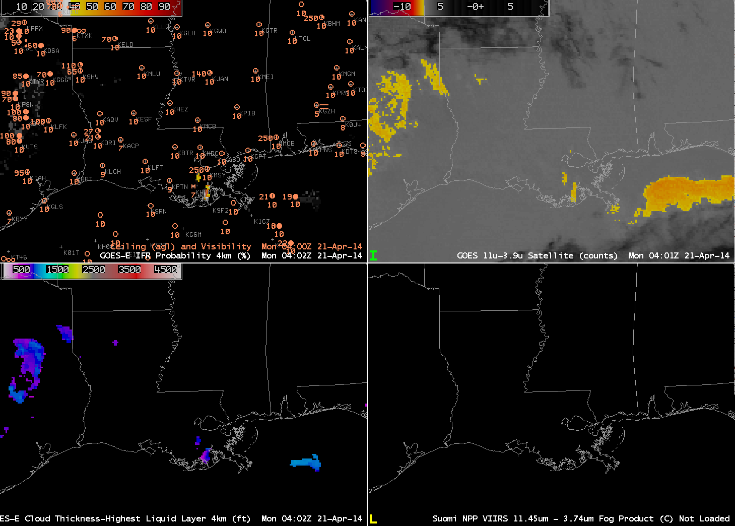
How did the IFR probability forecasts do during this event? At 0400 UTC (below), neither the IFR probabilities nor the traditional method of fog/low cloud detection suggest fog/low clouds are present.

GOES_IFR_PROB_20140421_0402

GOES-R IFR Probabilities computed from GOES-East (Upper Left), GOES-East Brightness Temperature Differences (10.7 µm – 3.9 µm) (Upper Right), GOES-R Cloud Thickness (Lower Left), Suomi/NPP VIIRS Brightness Temperature Difference (11 µm – 3.74 µm) (Lower Right), 0400 UTC on 21 April 2014 (click to enlarge) (click to enlarge)

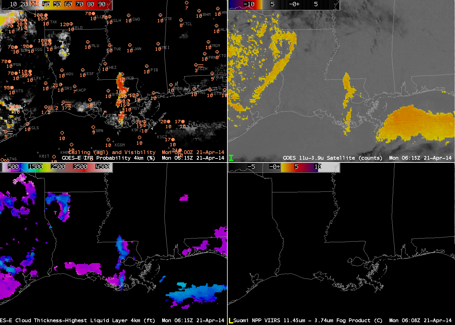
By 0600 UTC, IFR Probabilities have increased to around 10% in/around Lake Charles as visibilities have dropped. GOES-R Cloud Thickness values are around 600 feet.

GOES_IFR_PROB_20140421_0615

As above, but at 0615 UTC on 21 April 2014 (click to enlarge)

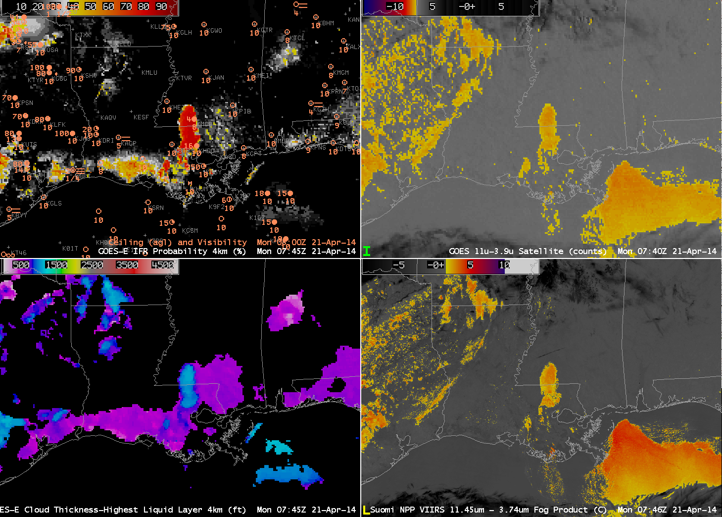
Just before 0800 UTC, a Suomi/NPP overpass provided high-resolution data. Neither the GOES-East nor the VIIRS data brightness temperature difference products show a distinct fog/stratus signal over southwestern Louisiana, where GOES-R Cloud Thickness values persist at around 600 feet, and where IFR probabilities have increased past 50%.

GOES_IFR_PROB_20140421_0745

As above, but at 0745 UTC on 21 April 2014 (click to enlarge)

By 1100 UTC (below), when the Dense Fog Advisory is issued (hours after the IFR Proabilities first increased), the Brightness Temperature Difference product from GOES-East is finally showing a faint (albeit noisy) signal of fog/low stratus over southwestern Louisiana. A stronger signal extends northeast and southwest from Baton Rouge.

GOES_IFR_PROB_20140421_1102

As above, but at 1100 UTC on 21 April 2014 (click to enlarge)

Low clouds and Fog along the West Coast

Low clouds and fog developed along the west coast this morning. From the Monterey (CA) AFD:

FXUS66 KMTR 141143
AFDMTR

AREA FORECAST DISCUSSION
NATIONAL WEATHER SERVICE SAN FRANCISCO BAY AREA
443 AM PDT FRI MAR 14 2014

.SYNOPSIS…AFTER A BIT OF COOLING TODAY…A WARM AND DRY UPPER LEVEL
RIDGE OF HIGH PRESSURE WILL BUILD STRONGLY INTO THE WEST COAST
OVER THE WEEKEND. THIS WILL RESULT IN AFTERNOON TEMPERATURES
REACHING WELL ABOVE SEASONAL NORMS…AND POSSIBLY TO NEAR RECORD
LEVELS FOR THESE DATES. THIS WARM-UP WILL BE SHORT-LIVED HOWEVER…WITH
INCREASED ONSHORE FLOW AND A SIGNIFICANTLY COOLER AIR MASS MOVING
IN ALOFT THE FIRST PART OF NEXT WEEK. DRY CONDITIONS ARE EXPECTED
TO CONTINUE THROUGH MID WEEK…BUT THEN WITH UPPER LEVEL TROUGHING
AND A CHANCE OF RAIN FOR THE OUTER PORTION OF THE FORECAST PERIOD.

&&

.DISCUSSION…AS OF 4:10 AM PDT FRIDAY…THE DRY TAIL END OF A
WEATHER SYSTEM MOVING IN TO THE PACIFIC NORTHWEST IS APPROACHING
OUR DISTRICT…AND RESULTING IN ENHANCEMENT OF THE MARINE LAYER
AND A RETURN OF THE MARINE STRATUS. LATEST GOES FOG PRODUCT
IMAGERY…AND IN RATHER SPECTACULAR DETAIL JUST REC’D SUOMI VIIRS
NIGHTTIME HIGH RES VISUAL IMAGE…SHOW COVERAGE ALONG MUCH OF THE
COAST FROM PT REYES SOUTH TO THE VICINITY OF THE MONTEREY
PENINSULA…AND A BROAD SWATH EXTENDING INLAND ACROSS SAN
FRANCISCO AND THROUGH THE GOLDEN GATE TO THE EAST BAY. LATEST
BODEGA BAY AND FT ORD PROFILER DATA INDICATE A MARINE LAYER DEPTH
OF ABOUT 1300 FT. SOME THIN HIGH CLOUDS ARE ALSO PASSING THROUGH ABOVE.

NAM MODEL AND IN-HOUSE LOCAL WRF MODEL BOUNDARY LAYER RH OUTPUT
BOTH INDICATE STRATUS SHOULD GENERALLY CLEAR BY MIDDAY…EXCEPT
ALONG THE SAN MATEO COAST AND IN THE VICINITY OF THE MONTEREY
PENINSULA. EXPECT AFTERNOON HIGHS TO BE AROUND 3 TO 5 DEGS COOLER
THAN ON THURSDAY…BUT STILL WELL ABOVE SEASONAL NORMS ESPECIALLY
INLAND.

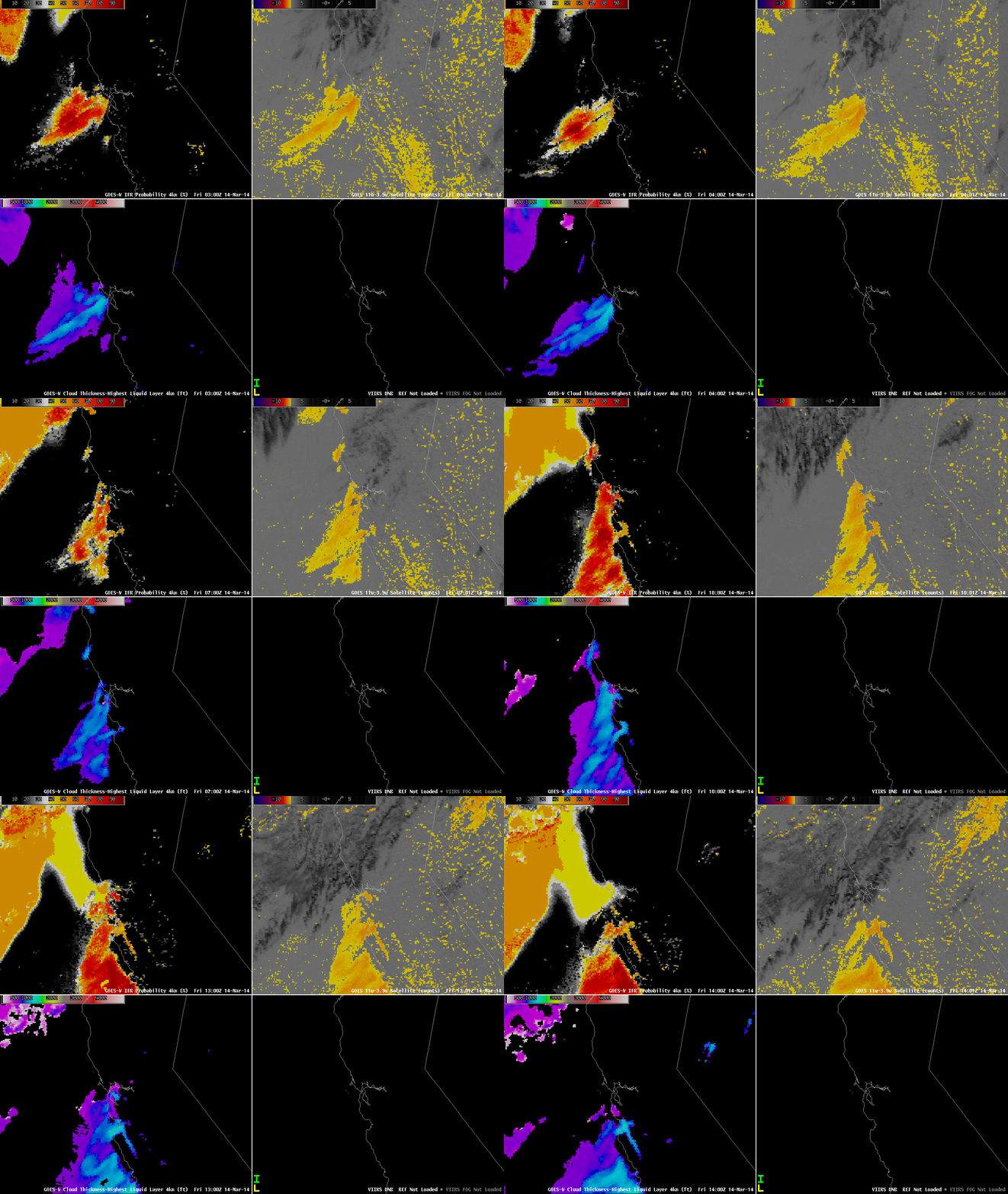
GOES_IFR_PROB_20140314loop

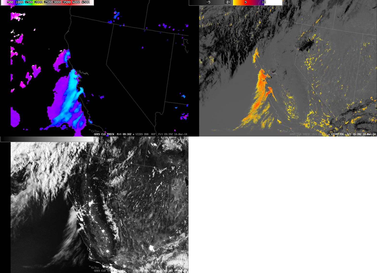
GOES-R IFR Probabilities computed from GOES-15 (Upper Left), GOES-West Brightness Temperature Differences (10.7 µm – 3.9 µm) (Upper Right), GOES-R Cloud Thickness (Lower Left), Suomi/NPP Day/Night Band (Lower Right), all hourly times as indicated (click to enlarge)

The animation of satellite and satellite-derived fields, above, shows how the GOES-R and GOES-West fields depicted the development of the low clouds. Note how the brightness temperature difference fields over CA and NV throughout the animation have a speckled appearance. These positive signals are due not to the presence of fog/low clouds but rather to differences in emissivity properties of the dry land. Near the end of the animation, high clouds are widespread over northern California. For such cases, the brightness temperature difference product provides little information about low-level clouds. However, the GOES-R IFR Probability field, because it blends together information from satellite and from Rapid Refresh does provide a signal under clouds. It is a much smoother signal because it does vary from one satellite pixel to the next, and the Probability values are smaller because satellite predictors cannot be used in the algorithm.

The AFD above notes the Day/Night band, and also the depth of the marine stratus. The toggle of Cloud Thickness, Day/Night Band, and brightness temperature difference, below (useful to distinguish white clouds from white city lights!), shows a nice overlap between the GOES-R product and the clouds detected at high resolution by Suomi/NPP. Cloud thickness is around 1150 feet at Bodega Bay, and closer to 1250 feet at Fort Ord, in good agreement with the profile data cited.

VIIRS_DNB__REF_GOES_CLD_THICK_20140314_09

Toggle of GOES-R Cloud Thickness, Suomi/NPP Brightness Temperature Difference and Day/Night Band (click to enlarge)

Fog Detection under Cirrus

GOES_IFR_PROB_20131202loop

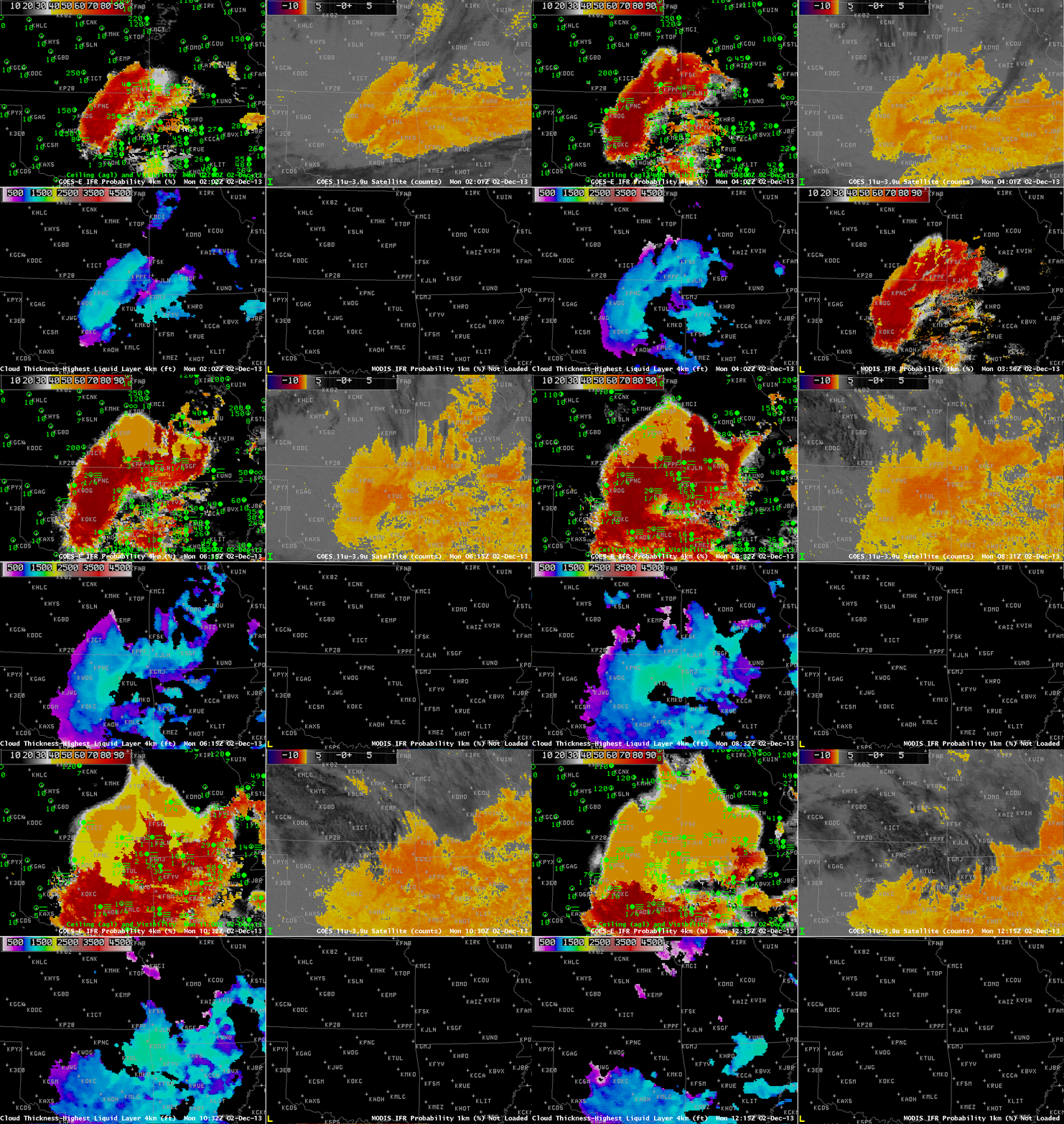
GOES-R IFR Probabilities from GOES-13 (Upper Left), GOES-13 Brightness Temperature Difference Product (10.7 µm – 3.9 µm) (Upper Right), GOES-R Cloud Thickness from GOES-13 (Lower Left), MODIS-based IFR Probabilities (Lower Right), Times as indicated (click image to enlarge)

Dense Fog developed over the southern Plains overnight, and the case demonstrates how the Fused data product is able to give a useful signal of IFR probabilities even in regions where high clouds preclude the detection of low clouds by satellite. The fog was widespread and dense enough to warrant Dense Fog Advisories from Tulsa, Norman and Topeka forecast offices. See below, for example.

000
FXUS64 KTSA 020953
AFDTSA

AREA FORECAST DISCUSSION
NATIONAL WEATHER SERVICE TULSA OK
353 AM CST MON DEC 2 2013

.DISCUSSION…
DENSE FOG CONTINUES THIS MORNING ACROSS MUCH OF THE CWA. GIVEN THE
TIME OF YEAR /LOW SUN ANGLE/ AND THE FACT THAT SOME HIGH CLOUDS ARE
STREAMING INTO THE AREA FROM THE NW /REDUCED INSOLATION AND
DELAYED MIXING/…THINK IT MAY TAKE A LITTLE LONGER THAN
PREVIOUSLY EXPECTED TO GET RID OF THE FOG. WE HAVE EXTENDED THE
DENSE FOG ADVISORY UNTIL 11 AM. ONCE THE FOG BURNS OFF…SHOULD
BE A PLEASANT DAY WITH UNSEASONABLY WARM TEMPS AND FAIRLY LIGHT
WIND. COULD BE SOME MORE FOG TUESDAY MORNING IN SOME PLACES BUT A
LITTLE MORE WIND MAY KEEP IT FROM GETTING AS DENSE AND AS
WIDESPREAD AS IT IS THIS MORNING. SLIGHTLY WARMER TEMPS IN STORE
TUESDAY WITH SOME PLACES LIKELY IN THE 70S. WARM AND WINDY
CONDITIONS WILL RESULT IN AN INCREASING FIRE WEATHER CONCERN.

Satellite detection of this fog event was constrained by the presence of two upper-level cloud decks. At the beginning of the animation, above, high clouds associated with the subtropical jet are over the southern quarter of the domain plotted. These high clouds quickly shift southward, and the region in the brightness temperature difference product that is consistent with detection of fog/low stratus (that is, low water-based clouds) expands to the south (surface observations suggest the low stratus clouds were present earlier, but masked by the higher clouds). Later in the animation, high clouds sag southward into the northern part of the domain. When this happens, low stratus/fog (indicated in observations by IFR conditions) are not detected by GOES because the higher ice clouds block the view of the scene. However, the IFR Probability fields that use both satellite data and output from the Rapid Refresh Model continue to depict a likely region (confirmed by the observations) of reduced visibilities. IFR Probabilities do drop, of course, as satellite data cannot be used to confirm the presence of low clouds. Knowledge of why the probabilities drop is vital to the interpretation of the field: You have to know that the high clouds are present, either by looking at the satellite data, or by understanding that the character of the IFR Probability field changes to one that is less pixelated when satellite data cannot be included because of ice clouds above the low stratus deck.

GOES_IFR_PROB_20131202_0802

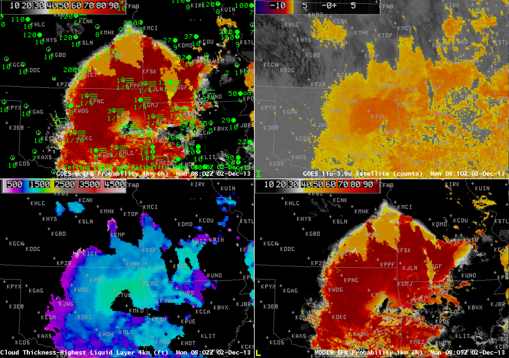
GOES-R IFR Probabilities from GOES-13 (Upper Left), GOES-13 Brightness Temperature Difference Product (10.7 µm – 3.9 µm) (Upper Right), GOES-R Cloud Thickness from GOES-13 (Lower Left), MODIS-based IFR Probabilities (Lower Right), Times near 0802 UTC as indicated (click image to enlarge)

For a large-scale event like this, MODIS-based IFR Probabilities overlap well with GOES-Based IFR Probabilities, as shown in the image above. In cases like this sometimes individual river valleys will show up with slightly elevated IFR Probabilities (or cloud thicknesses).

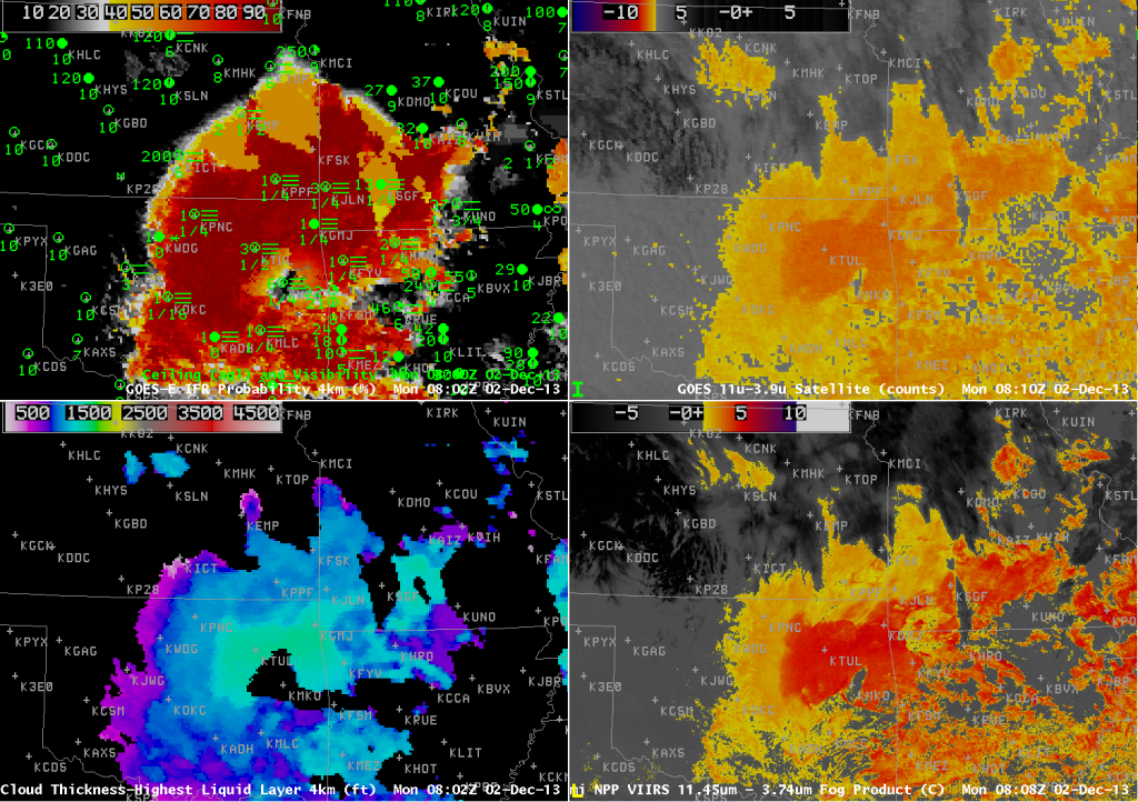
The GOES-R Cloud Thickness field is computed for the highest water-based cloud detected (during non-twilight conditions — that is, not during the hour or so surrounding sunrise and sunset). Note how well the thickest clouds — over northeast OK, surrounding Tulsa — correlate with the strongest Brightness Temperature Difference, both in GOES and in Suomi/NPP data (below). Note also how the Cloud Thickness field is not computed in regions where higher ice-based clouds are present.

VIIRS_FOG_20131202_0808

GOES-R IFR Probabilities from GOES-13 (Upper Left), GOES-13 Brightness Temperature Difference Product (10.7 µm – 3.9 µm) (Upper Right), GOES-R Cloud Thickness from GOES-13 (Lower Left), Suomi/NPP Brightness Temperature Difference from VIIRS (10.35 µm – 3.74 µm) (Lower Right), Times near 0802 UTC as indicated (click image to enlarge)

Cloud Thickness can be used to predict the time of fog dissipation, using this scatterplot/relationship. If sun angle is limited by the season, or if solar insolation is limited by higher clouds, you might adjust the first guess for dissipation to a later time.

Lake Michigan Fog

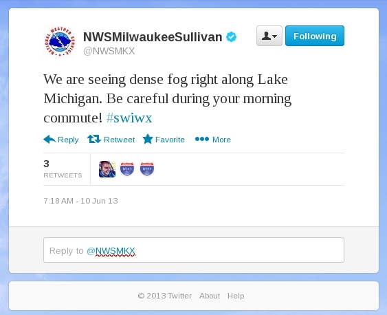
Fog from Lake Michigan is a year-round hazard for travel in eastern Wisconsin.  One of the biggest crashes on an interstate in Wisconsin occurred in October 2002 on I-43 near Sheboygan as fog moved onshore.  Ten died in that event that included 25 vehicles.

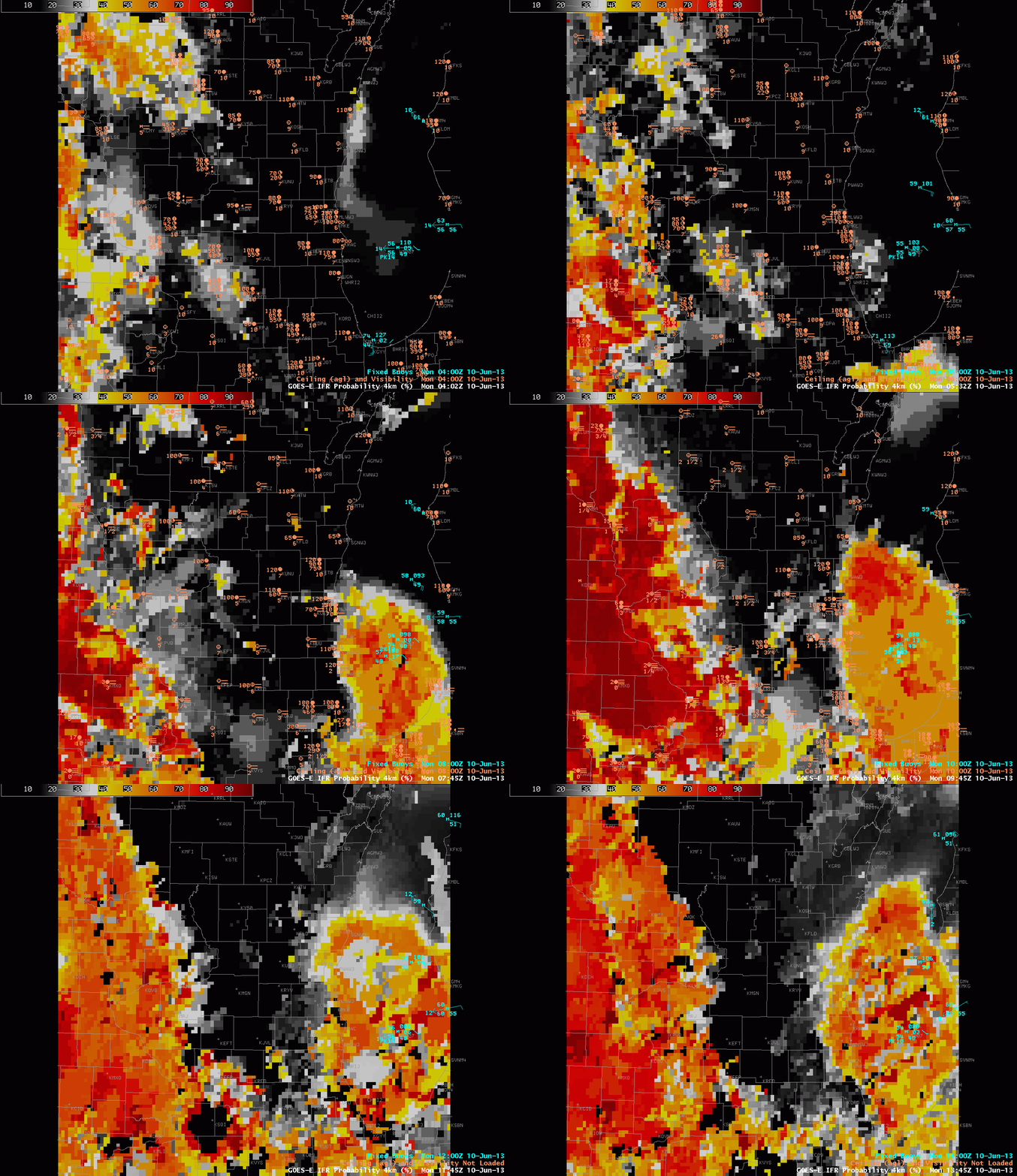
Rain overnight followed by partial clearing led to widespread fog over the upper Midwest on June 10, 2013, and the IFR Probability products described the horizontal extent of the lowest visibilities.  Those low visibilities hugged the coast of Lake Michigan in eastern Wisconsin.

GOES-R IFR Probabilities, 0402 – 1345 UTC on 10 June 2013, computed from GOES-East

GOES-R IFR probabilities increase in two regions overnight:  over Iowa and in the western Wisconsin River Valleys, and over Lake Michigan.  Reduced visibilities are reported in and around Lake Michigan, and as the tweet up top shows, dense fog was reported along highways as well.  Water temperatures in the upper 40s over central Lake Michigan promote the development of fog, as dewpoints over Wisconsin were near 60.

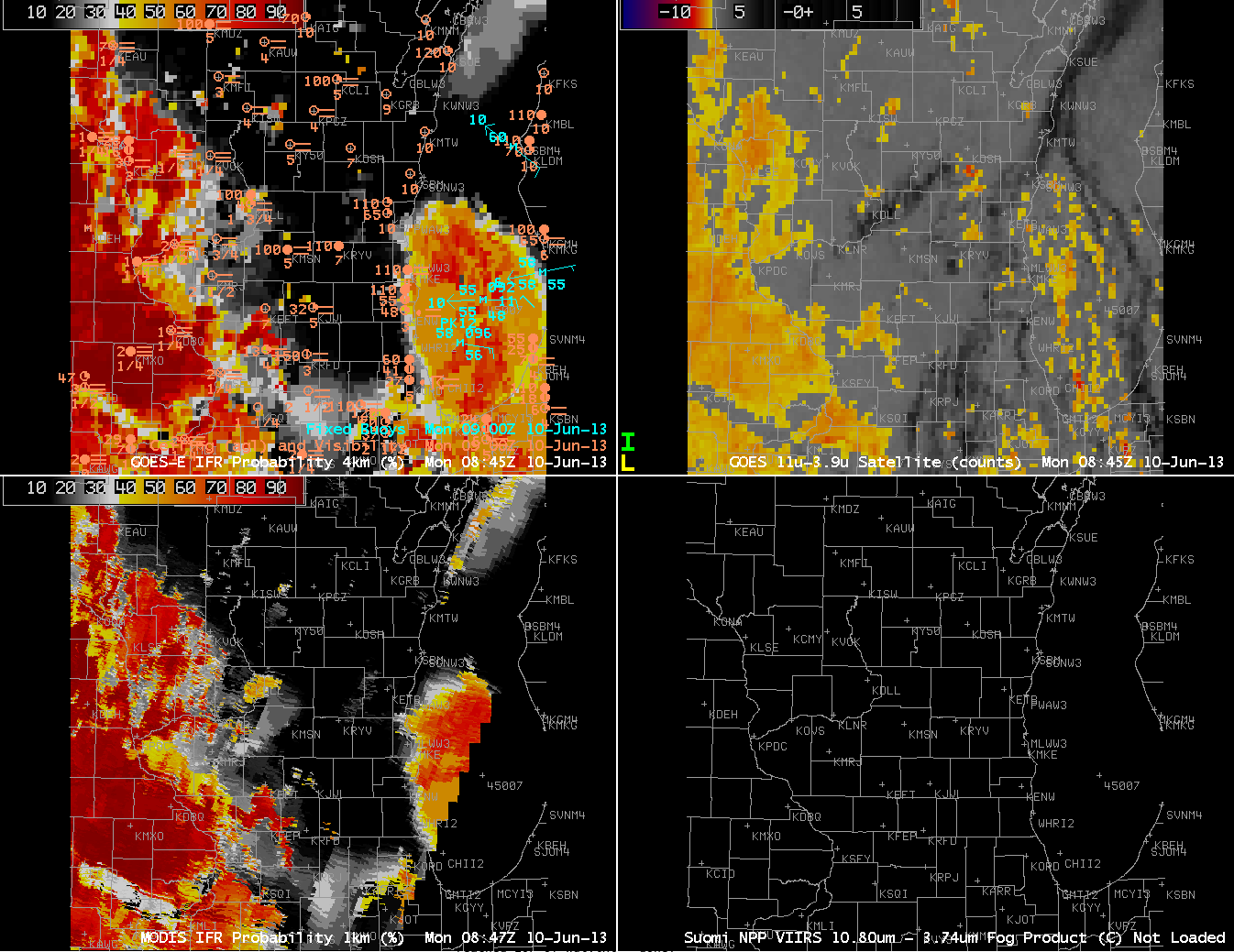
GOES-R IFR Probabilities computed from GOES-East (Upper Left) and from MODIS (Lower Left);  GOES-East Brightness Temperature Difference Product (Upper Right), all from approximately 0845 UTC on 10 June 2013

The GOES Imager usually cannot resolve small river valleys.  Polar-orbiting data, however, usually can.  The MODIS-based IFR probability from 0847 UTC better resolves the Wisconsin River Valley over southwest Wisconsin, for example.