Category Archives: Texas

Low Stratus under Cirrus

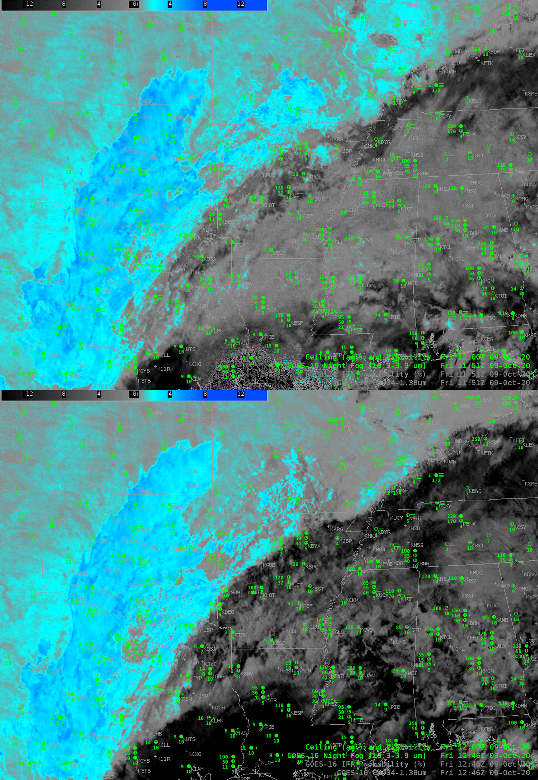
GOES-16 ‘Night Fog’ Brightness Temperature Difference (10.3 µm – 3.9 µm), 1151 and 1246 UTC on 9 October 2020 (Click to enlarge)

The extensive cirrus shield from Hurricane Delta in the Gulf of Mexico made difficult the satellite-based detection of stratus and low clouds over much of the Deep South on Friday 9 October. The Night Fog Brightness Temperature Difference is also affected by increased solar reflectivity at 1246 UTC in the imagery above. The low clouds over southern Illinois are no longer detected, for example, and the high cirrus of Delta becomes much darker — in both cases because of increased reflectivity of 3.9 µm solar radiation.

The toggle below between the Night Fog Brightness tempreature difference and the Band 4 near-infrared “Cirrus” channel just after sunrise (1246 UTC) shows the extensive cirrus signal in both images. Widespread cirrus is not uncommon, thus the difficulty in detection is not uncommon
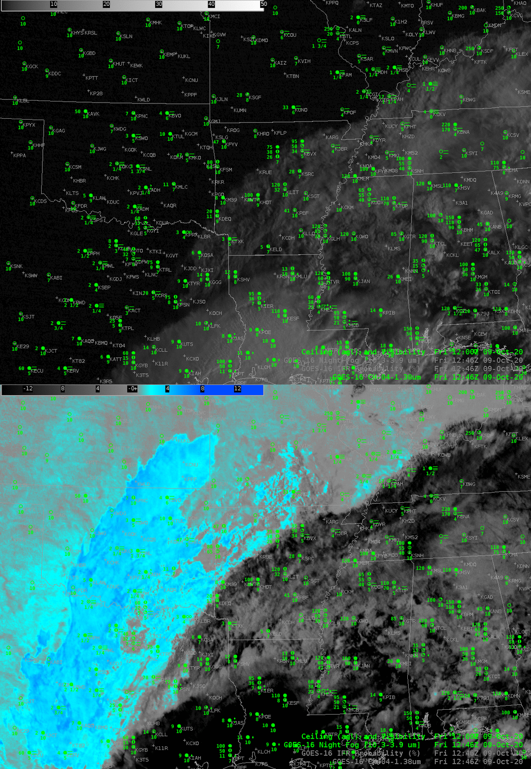
GOES-16 Night Fog Brightness Temperature Difference (10.3 µm – 3.9 µm) and near-infrared 1.38 µm “Cirrus” Band 4, 1246 UTC on 9 OCtober 2020 (Click to enlarge)

GOES-R IFR Probability fields, below, compared to the Night Fog Brightness Temperature fields highlight how IFR Probability, which fields include information about low-level saturation in the Rapid Refresh model, capably fills in regions of fog/low stratus underneath high clouds. It is useful for situational awareness in fog detection when satellite imagery is showing only upper-level clouds. For example, note the large values of IFR Probability in western Kentucky, under the high cirrus, or in northeast Texas! There is good spatial correlation between high IFR Probabilities and reduced ceilings/visibilities. The correlation between the Night Fog Brightness Temperature difference field and reduced ceilings/visibilities is smaller because of low visibility under cirrus (as occurring over northwestern TN and much of LA, for example). Note that IFR Probability fields also give information where IFR conditions are not occurring under cirrus: central Mississippi, for example.
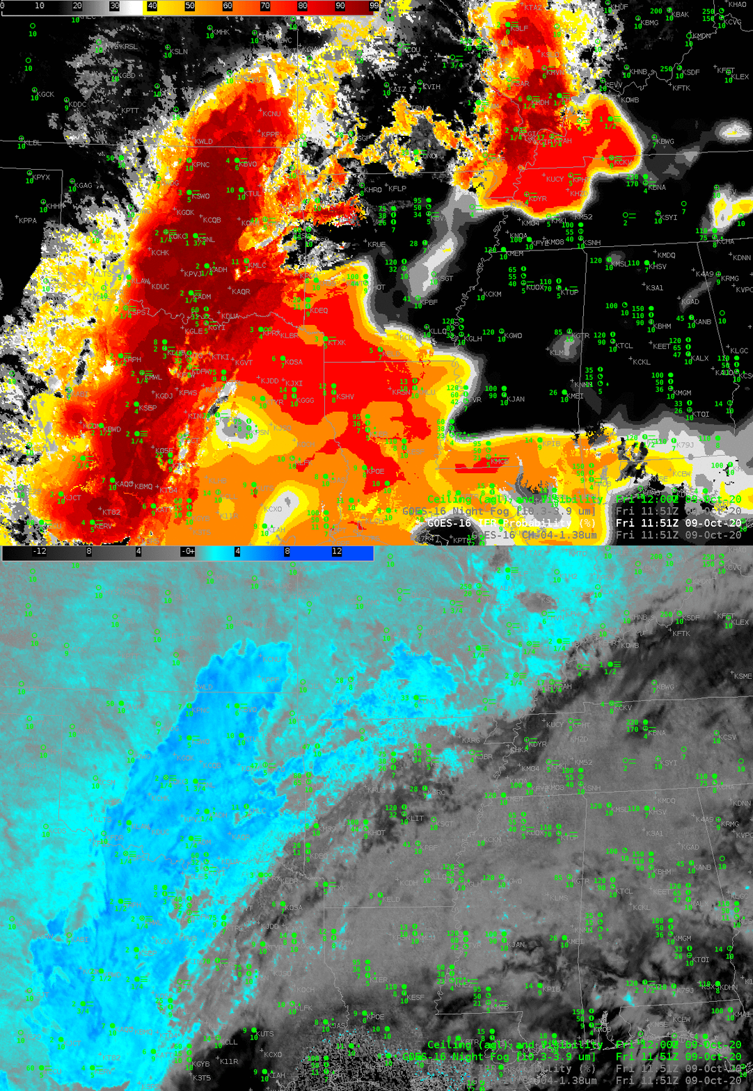
GOES-16 IFR Probability and Night Fog Brightness Temperature Difference (10.3 µm – 3.9 µm) at 1151 UTC on 9 October 2020 (Click to enlarge)

IFR Probability fields through sunrise (below) show a consistent signal, in part because of the Rapid Refresh model information on saturation.

GOES-16 IFR Probability fields, 1151 and 1246 UTC on 9 October 2020 (Click to enlarge)

The CIMSS-driven LDM feed that has supplied GOES-16 IFR Probability fields (and before GOES-R’s launch, GOES-13 and GOES-15 IFR Probability fields) to NWS offices will be terminated on or about 20 October. Operational creation of GOES-16 IFR Probability fields has shifted to NOAA/NESDIS, and the fields are now sent over the SBN to forecast offices. TOWR-S Build 19 is required to access and display these fields in AWIPS.

IFR Conditions over the southern Plains

Click to enlarge
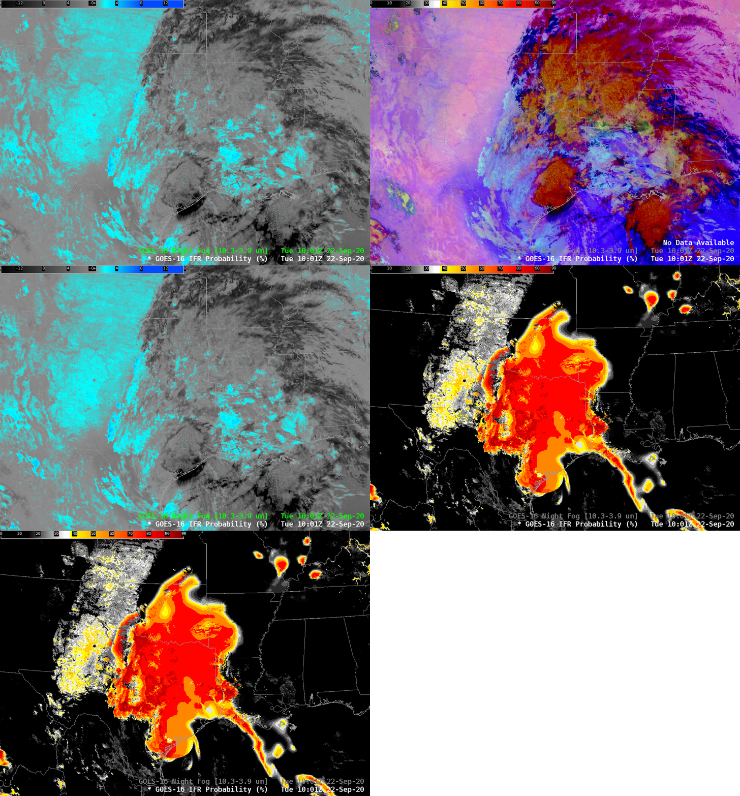
GOES-16 Night Fog Brightness Temperature Difference (10.3 µm – 3.9 µm), Night TIme Microphysics RGB, and IFR Probability, 1001 UTC on 22 September 2020 (Click to enlarge)

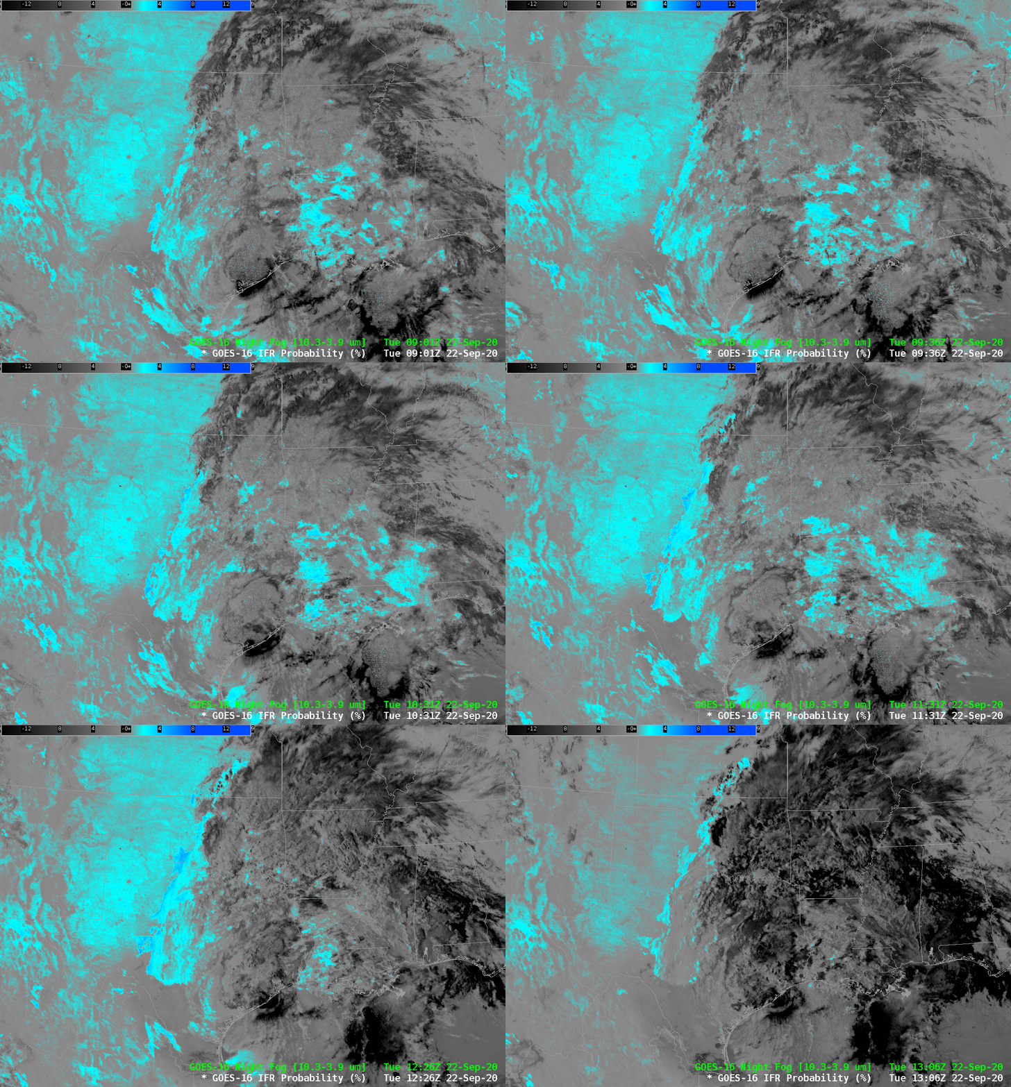
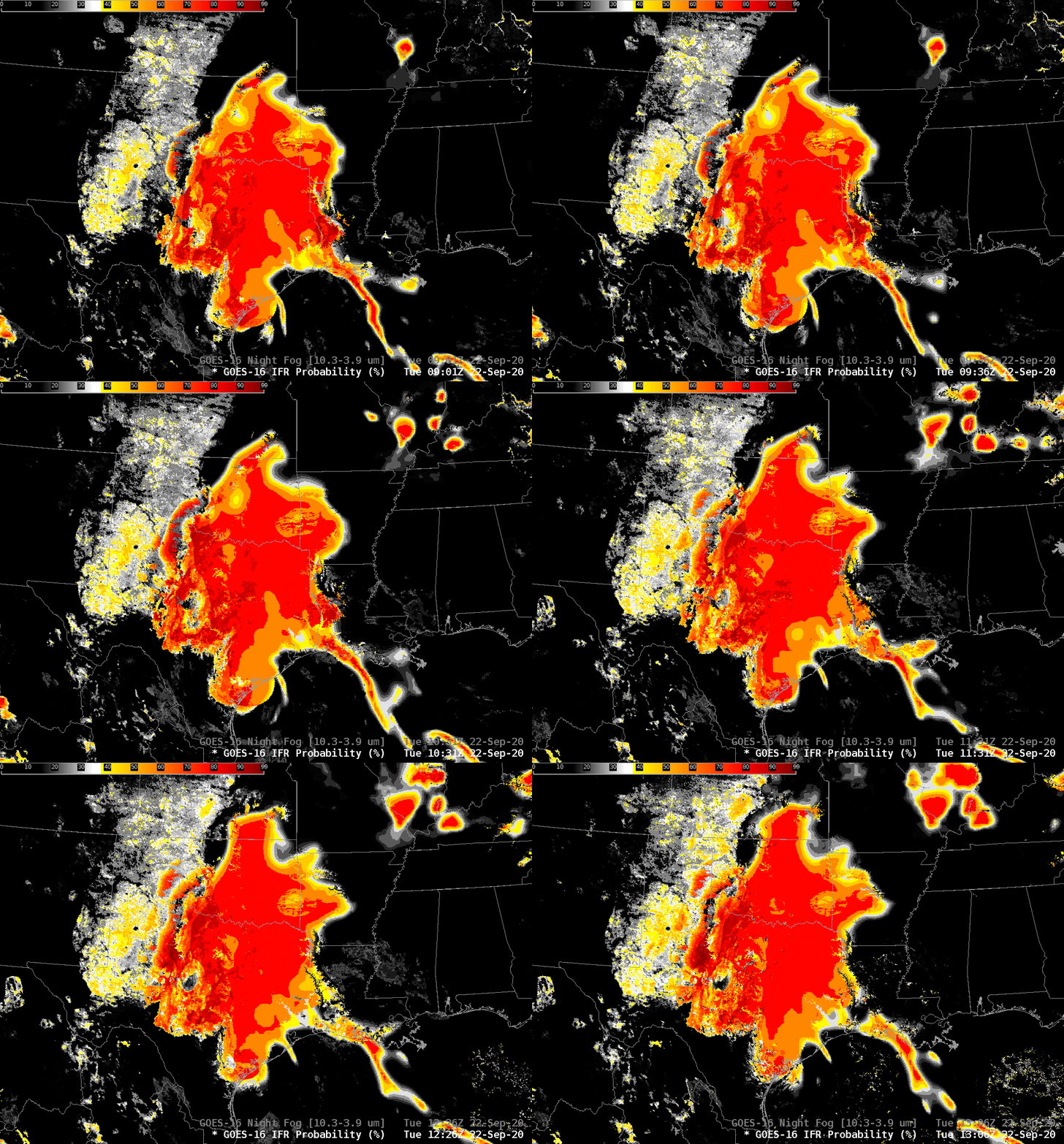
Widespread mid- and upper-level cloudiness over the southern Plains associated with Tropical Storm Beta on 22 September 2020 make it difficult to use satellite data alone to identify where low clouds and fog might exist. This is a day where IFR conditions exist, as shown here, an image from this website. Where would you expect IFR conditions to exist within this field of view? The Night Fog brightness temperature difference, below, (and, by extension, the Nightime Microphysics RGB) shows scant information over eastern Texas/Oklahoma or ArkLaTex. IFR Probability fields, in contrast, have a definite signal of high probability.

The animation of the Night Fog Brightness Temperature Difference field, below, also highlights a challenge in using this product: increasing reflection of solar 3.9 radiation occurs as sunrise progresses, changing the character of the field. Further, soils can have emissivity properties that are similar to clouds, and a positive Night Fog Brightness Temperature difference signal results. (This is especially true in dry regions, such as west Texas; linked-to map from this website).

GOES-16 Night Fog Brightness Temperature Difference (10.3 µm – 3.9 µm), 0901 – 1306 UTC on 22 September 2020 (Click to enlarge)
GOES-16 IFR Probability, 0901-1306 UTC on 22 September 2020 (Click to enlarge)

IFR Probability fields for the same time as the Night Fog Brightness Temperature Difference, above, show a consistent region where IFR conditions are most likely. The region over the high Plains of Texas that has a signal in the Brightness Temperature Difference field has low probabilities because in that region, the Rapid Refresh model is not suggesting widespread low-level saturation. In contrast, the Rapid Refresh model over east Texas/Oklahoma, western Louisiana and southwest Arkansas does show saturation.

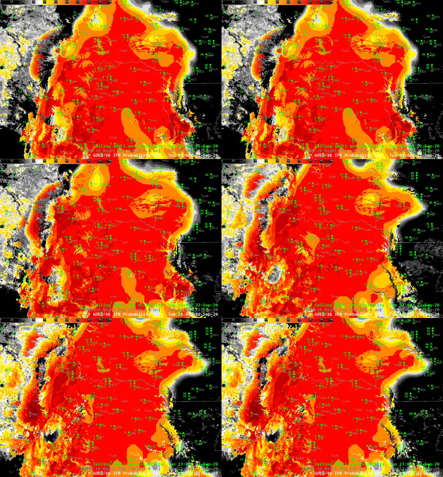
What do observations shows? The hourly observations overlain on the IFR Probability fields, below, show that IFR and near-IFR conditions are widespread within the region of high IFR Probability. Outside that region, IFR conditions are rare.

GOES-R IFR Probability fields, 0906, 1001, 1101, 1201 and 1301 UTC along with observations of ceilings and visibilities (Click to enlarge)

IFR Probability fields are flowing over the SBN to forecast offices. (TOWR-S RPM 19 is needed to display them from that data source). IFR Probability fields are also available via an LDM feed from Regionals if RPM 19 is not installed. They are available online at this website.

Sea Fog near Corpus Christi

GOES-16 ABI Band 02 (0.64 mm “Red Visible”) visible imagery, 1201-2311 UTC on 20 April 2020

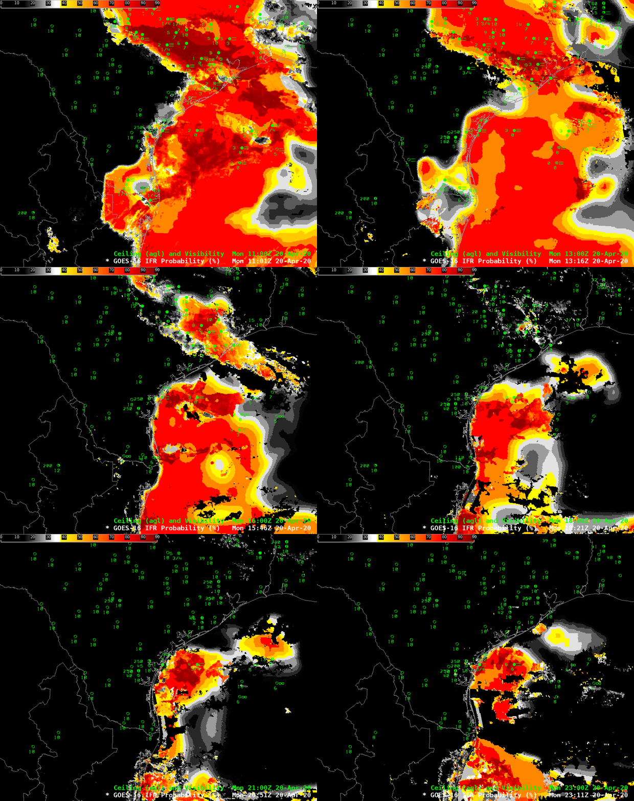
GOES_16 Visible imagery, above (along with surface observations of ceilings and visibilities), shows fog and low clouds over south Texas and offshore waters. The observations plotted can allow you to determine where IFR conditions are apparent — where visibilities are between 1 and 3 statute miles and ceilings are between 500 and 1000 feet. It’s difficult to determine the area of IFR conditions based solely on cloud cover however.

The animation below shows the probability of IFR conditions, a product that fuses satellite information with low-level saturation information from the Rapid Refresh model (Click here for an animation with no observations). The morning fog over east Texas burns off fairly quickly, and only dense sea fog is left after about 1700 UTC (10 AM CDT). In many offshore regions (and over east Texas before sunrise), the IFR Probability field has a flat character to it that is typical of a IFR Probability field determined mostly by model data. More pixelated data (and somewhat higher probabilities) occur where breaks in the cloud allow for satellite data to identify low clouds.

GOES-R IFR Probability, 1101 UTC to 2311 UTC on 20 April 2020

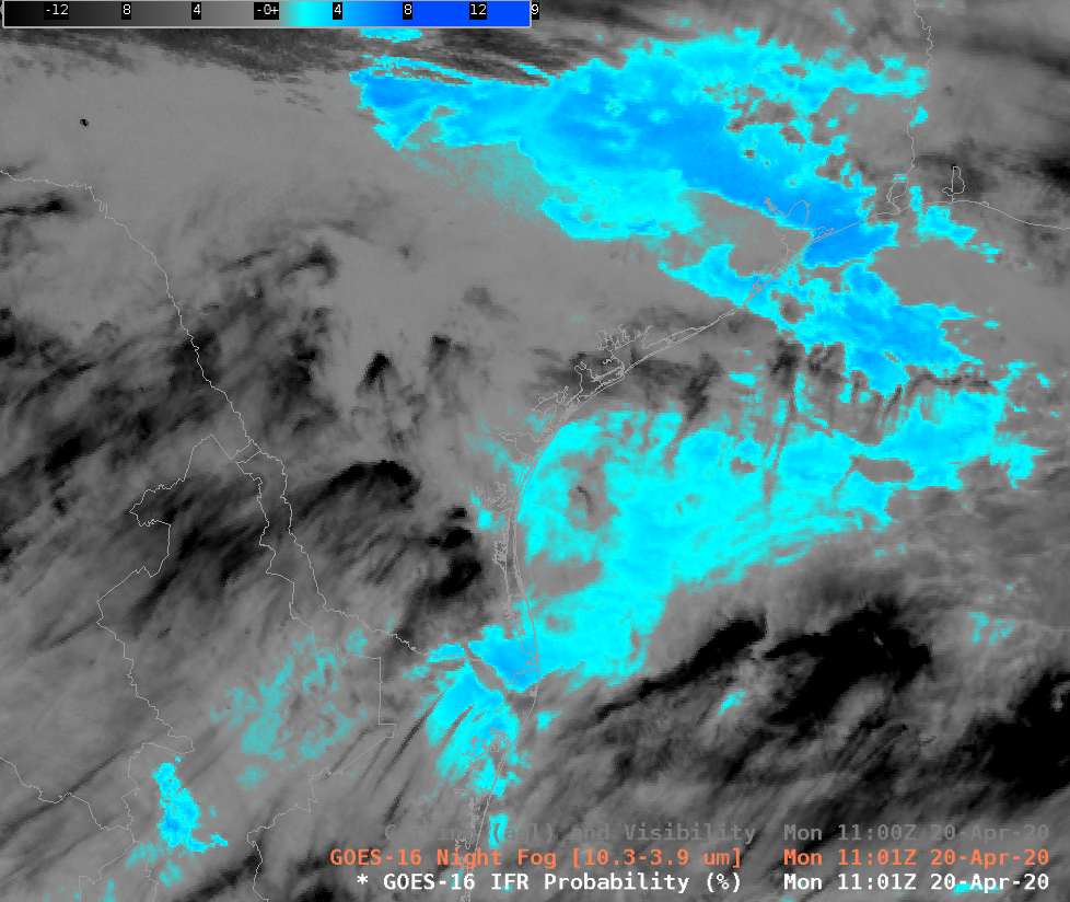
The night fog brightness temperature difference field, below, highlights a challenge in identifying low clouds using satellite data alone (in contrast to the IFR Probability above that uses satellite and model data, fusing the strengths of both). When cirrus is present, it can mask the satellite’s view of the low cloud beneath. In addition, the Night Fog Brightness Temperature difference product is not consistent through sunrise, as the emissivity differences that drive the signal at night time (small cloud droplets are not black body emitters of 3.9 µm radiation, but they are blackbody emitters of 10.3 µm radiation) become overwhelmed by reflectivity differences during the day when far more 3.9 µm solar radiation is reflected than 10.3 µm solar radiation. Thus, in the day, both low clouds and high clouds show up as black in this enhancement: they are both able reflectors of 3.9 µm radiation.

Night Fog Brightness Temperature Difference (10.3 µm – 3.9 µm) fields from 1101 UTC to 2311 UTC on 20 April 2020

The Day Fog Brightness Temperature Difference field, below, shows how cirrus ice crystals are initially more reflective of solar radiation, but as the sun climbs higher in the sky, low clouds start to reflect just as much solar radiation.

Day Fog Brightness Temperature Difference (3.9 µm – 10.3 µm) fields from 1201 UTC to 2311 UTC on 20 April 2020
GOES-16 Night Fog Brightness Temperature Difference (10.3 µm – 3.9 µm), 1101 UTC on 20 April 2020

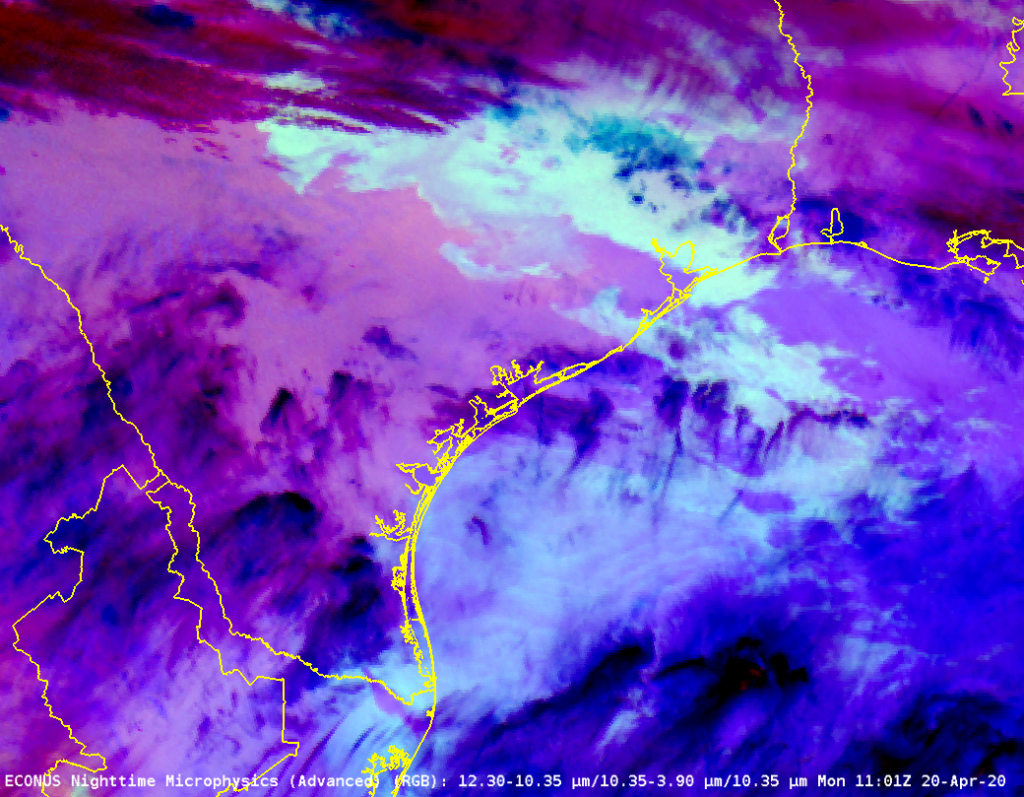
The Night Fog Brightness Temperature Difference field, above, is a key component (the ‘green’ part) of the Advanced Night Time Microphysics RGB, shown below. Where the Brightness Temperature Difference field is unable to view low clouds, similarly the Night Time Microphysics RGB will be unable to highlight them.

GOES_16 Night Fog Microphysics, 1101 UTC 20 April 2020

Thanks to Penny Harness, WFO Corpus Christi, for alerting us to this event. (Link)

IFR Probability, Brightness Temperature Differences and Nighttime Microphysics RGB estimates of Fog

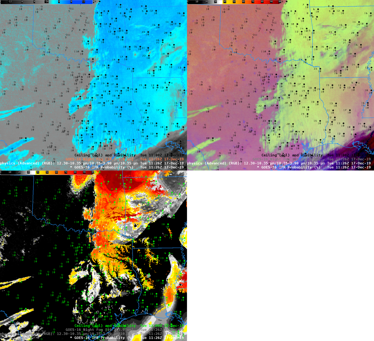
GOES-16 Brightness Temperature Difference (10.3 µm – 3.9 µm), Nighttime Microphysics RGB and IFR Probability Fields, 1126 UTC on 17 December 2019. Also included are sky conditions, ceilings and visibilities in black or green.

Fog and low clouds were widespread over the eastern half of the United States on 17 December 2019. In this example over ArklLaTex the Brightness Temperature Difference suggests low stratus clouds over the region, and the Nighttime Microphysics shows a signal congruent with low clouds. Note, however, that observations over much of the region do not suggest IFR conditions are present. Accordingly, IFR Probability shows fairly low probabilities in this region, with values increasing to the north where visibilities decrease. IFR Probability fields screen out regions of elevated stratus because the Rapid Refresh model in this region does not suggest low-level saturation. Over northeast Oklahoma and northwest Arkansas, however, saturation at low levels is more likely and IFR Probabilities there are larger.

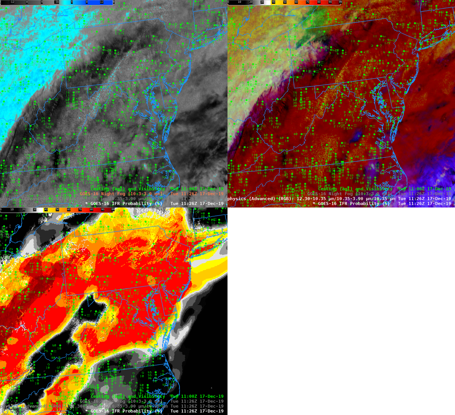
GOES-16 Brightness Temperature Difference (10.3 µm – 3.9 µm), Nighttime Microphysics RGB and IFR Probability Fields, 1126 UTC on 17 December 2019. Also included are sky conditions, ceilings and visibilities in green.

At the same time, high clouds overspread most of the east coast as a storm moved through the area. The high clouds prevent the satellite from seeing low clouds, so both the Brightness Temperature Difference and the Nighttime Microphysics RGB will not have a signal that comports with low stratus detection. However, IFR Probability includes a signal from the Rapid Refresh model if that model shows low-layer saturation in a region of multiple cloud layers; IFR Probability has a strong signal on this date over the east coast were clouds and fog are widespread. IFR Probability also shows IFR Conditions under the low clouds that the satellite does detect over eastern Ohio, and correctly notes the a region of higher ceilings over West Virginia, western Virginia and eastern Tennessee.

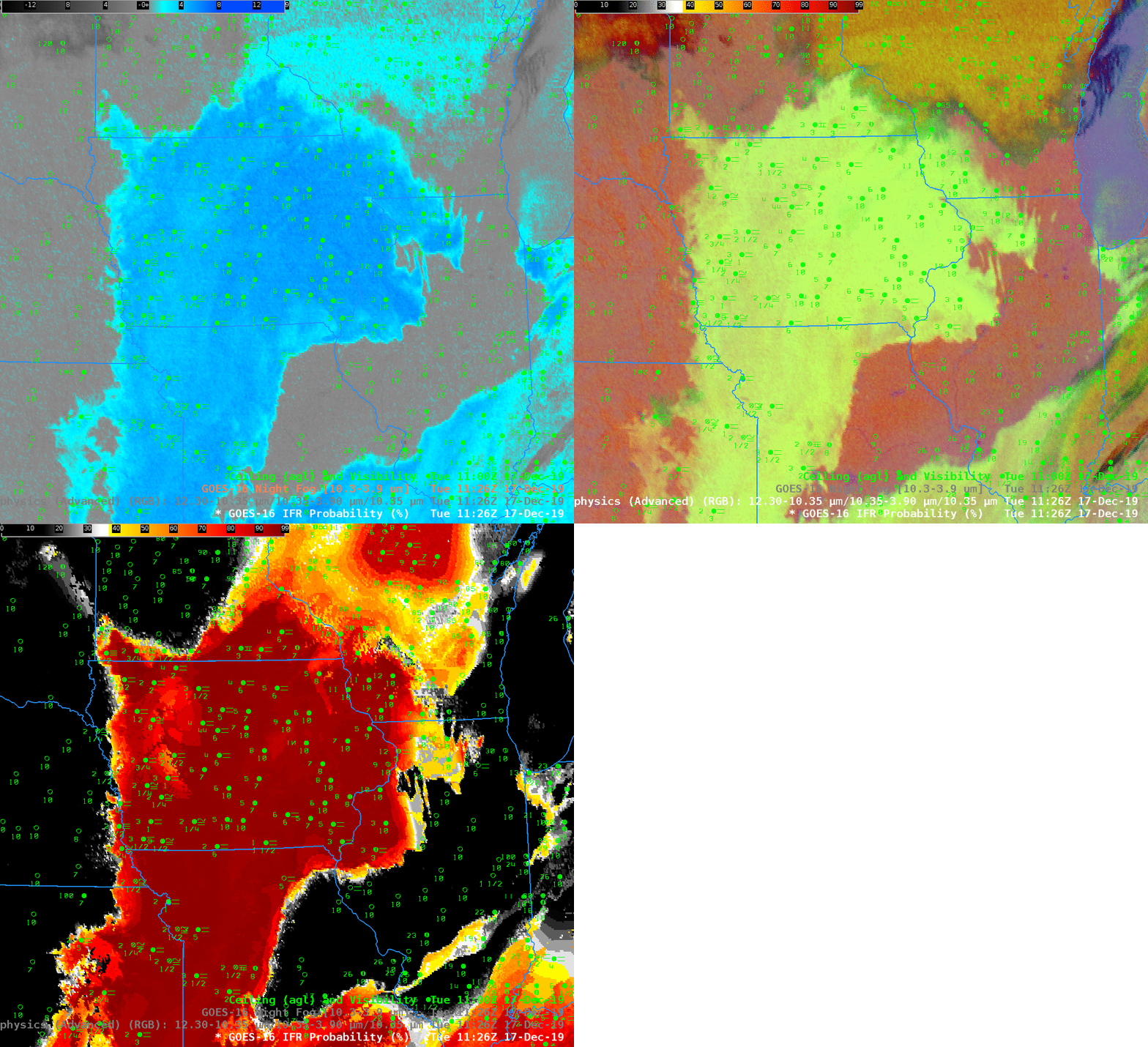
GOES-16 Brightness Temperature Difference (10.3 µm – 3.9 µm), Nighttime Microphysics RGB and IFR Probability Fields, 1126 UTC on 17 December 2019. Also included are sky conditions, ceilings and visibilities in green.

When high clouds are not present, there are different equally good ways to estimate low clouds, and that’s shown above. The Brightness Temperature Difference fields, the Nighttime RGB and the IFR Probability fields all tell a similar tale: Much of Iowa and regions to the south and northeast have low ceilings and reduced visibility.

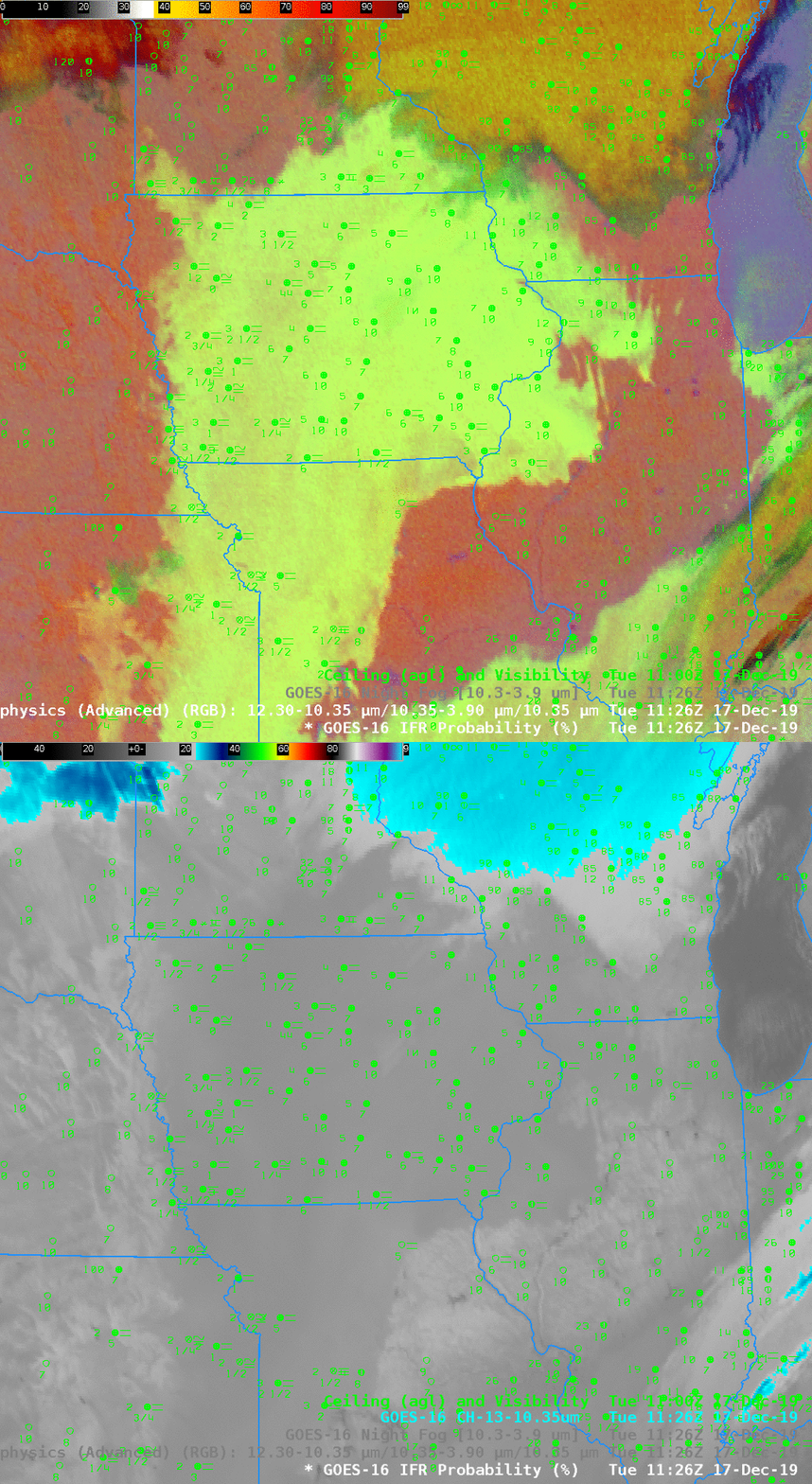
Careful observers to the toggle note that the RGB has a different color over Wisconsin compared to Iowa. In part this is because the Brightness Temperature Field has values that are smaller over Wisconsin. A bigger driver of the color difference, however, is the 10.3 µm brightness temperature — the blue component of the Nighttime Microphysics RGB. Values are around -25º C over Wisconsin, and closer to -10º C over Iowa!

Nighttime Microphysics RGB and Band 13 10.3 µm Brightness Temperature, 17 December 2019

Fog detection when Cirrus is present: Southern Plains edition

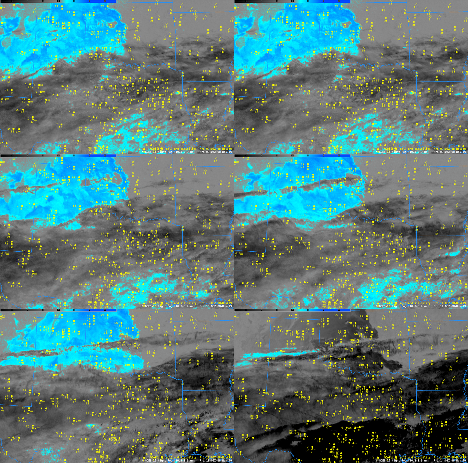
GOES-16 Night Fog Brightness Temperature Difference (10.3 µm – 3.9 µm) at 0906, 1006, 1106, 1206, 1306 and 1401 UTC on 8 November 2019 (Click to enlarge)

Consider the stepped 1-hour images of the ‘Night Fog’ Brightness Temperature Difference (10.3 – 3.9) field, above. (Here’s one with full temporal resolution) Extensive jet stream cirrus is preventing GOES-16 from seeing evidence of low clouds, and the satellite alone is therefore failing to identify regions of low ceiling and fog over much of Texas.  (The Nighttime Microphysics RGB that depends on the Night Fog brightness temperature difference to detect low clouds suffers from a similar shortcoming here : link )

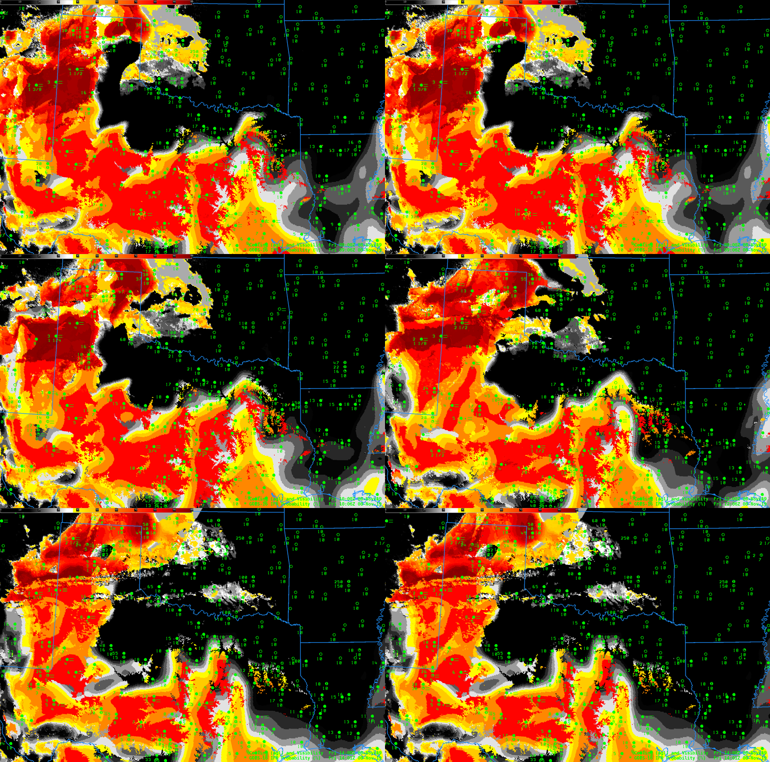
When Cirrus covers an area of low clouds, GOES-R IFR Probability does allow for low cloud/fog detection because it incorporates low-level saturation information from the Rapid Refresh to delineate regions of fog.  Similarly, it can screen out regions of mid-level stratus that can appear as fog in both the Night Fog brightness temperature difference and the Nighttime Microphysics RGB: Note the region around Childress TX, for example, where IFR Probability is low, but where the Night Fog Brightness Temperature Difference has a strong signal in the presence of elevated stratus.  Regions around Midland are highlighted in IFR Probability — Rapid Refresh data there are correctly diagnosing low ceilings and reduced visibilities.  (Here’s IFR Probability with an animation at full temporal resolution).  Because Rapid Refresh model data input into the IFR Probability computation changes every hour, you will sometimes see a pulsing in the imagery.

Use IFR Probability to detect regions of low ceilings and reduced visibility when cirrus has overspread your area.

GOES-R IFR Probability at 0906, 1006, 1106, 1206, 1306 and 1401 UTC on 8 November 2019 (Click to enlarge)


Cloud Layers and Detection of IFR Conditions

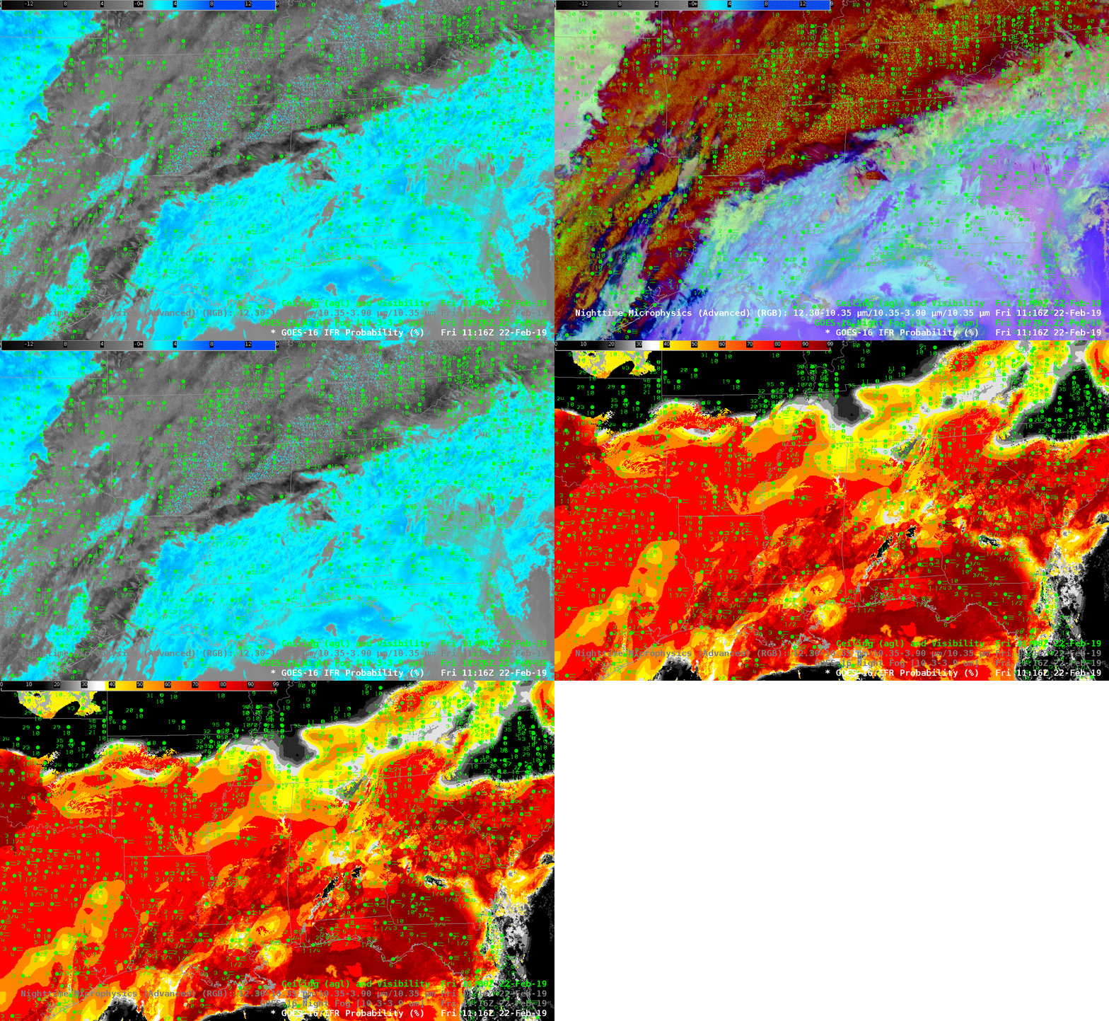
GOES-16 Night Fog Brightness Temperature Difference (10.3 µm – 3.9 µm), Nighttime Microphysics RGB and GOES-16 IFR Probability at 1116 UTC on 22 February 2019; Surface observations of ceilings and visibilities at 1100 UTC are also plotted (Click to enlarge).

A strong storm embedded within a subtropical jet stream over the southern United States was associated with widespread fog on the morning of 22 February 2019. This screen-capture from this site shows Dense Fog Advisories over much of Georgia, and over regions near Dallas. Which products allowed an accurate depiction of the low ceilings and reduced visibilities?

The toggle above cycles between the Night Fog Brightness Temperature Difference (10.3 µm – 3.9 µm), which product identifies low clouds (cyan blue in the default AWIPS enhancement shown) because of differences in emissivity at 3.9 µm and 10.3 µm from small water droplets that make up stratus clouds, the Nighttime Microphysics RGB, which RGB uses the Night Fog Brightness Temperature Difference as it green component, and the GOES-16 IFR Probability product.  IFR conditions are defined as surface visibilities between 1 and 3 miles, and ceiling heights between 500 and 1000 feet above ground level.  The plotted observations help define where that is occurring.  Multiple cloud layers from Arkansas east-northeastward make a satellite-only detection of IFR conditions challenging.  IFR Probability gives useful information below cloud decks because model-based saturation information from the Rapid Refresh Model fill in regions below multiple cloud decks where satellite information about low clouds is unavailable.

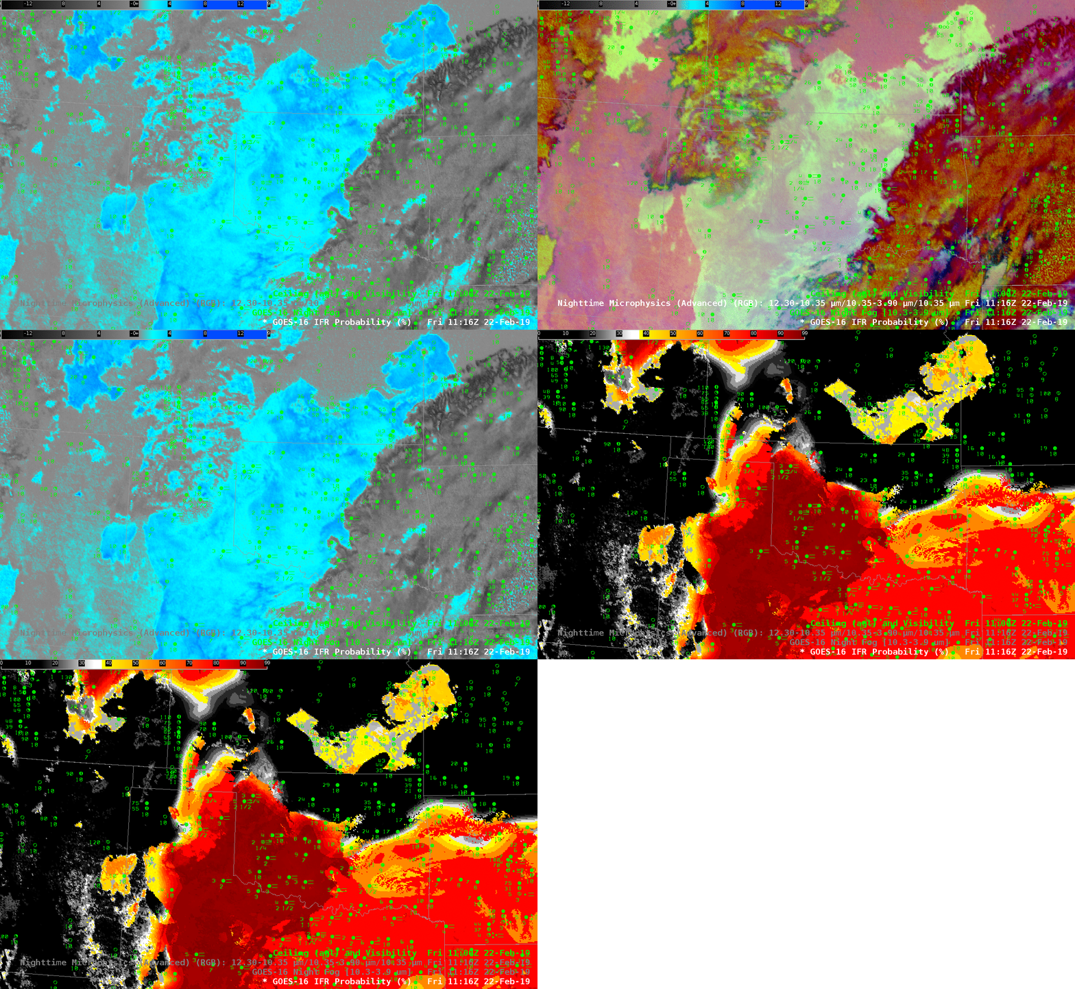
The toggle below shows the same three satellite-based fields (Night Fog Brightness Temperature Difference, Nighttime Microphysics RGB and IFR Probability)  at the same time, but centered over Oklahoma.  In this case, the Rapid Refresh Data are used to screen out a region of elevated stratus over northeast Oklahoma. Note that these is little in the Night Fog Brightness Temperature Difference field to distinguish between the IFR and non-IFR locations.

GOES-16 Night Fog Brightness Temperature Difference (10.3 µm – 3.9 µm), Nighttime Microphysics RGB and GOES-16 IFR Probability at 1116 UTC on 22 February 2019; Surface observations of ceilings and visibilities at 1100 UTC are also plotted (Click to enlarge).

GOES-R IFR Probability over the southeast United States in this case is identifying regions of IFR conditions underneath multiple cloud decks (and also where only the low clouds are present) by incorporating low-level saturation information from the Rapid Refresh model. Over Oklahoma, non-IFR conditions under an elevated stratus deck are identified (and screened out in IFR Probability fields) by the lack of low-level saturation information in the Rapid Refresh.

Fog over the central United States

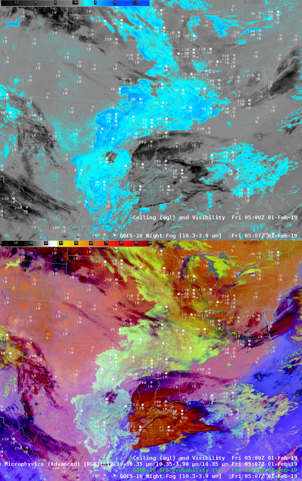
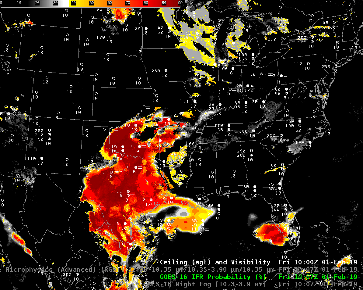
Night Fog Brightness Temperature Difference (10.3 µm – 3.9 µm) and Nighttime Microphysics RGB at 0507 UTC on 1 February 2019, and surface observations of ceilings and visibilities (Click to enlarge)

The toggle above displays the Night Fog Brightness Temperature Difference field (10.3 µm – 3.9 µm) and the Night Time Microphysics Red/Green/Blue (RGB) Product that uses the Night Fog Brightness Temprature Difference field as its green value. In the color enhancements above, cyan in the Night Fog Brightness Temperature Difference denotes positive values that occur because stratus clouds — that is, clouds that are made up of water droplets — do not emit 3.9 µm radiation as a blackbody. Consequently, the computation of brightness temperature (which assumes blackbody emission) results in a 3.9 µm brightness temperature that is cooler than at 10.3 µm (clouds are emitting 10.3 µm radiation very nearly like a blackbody).  Low clouds in the RGB that may or may not support IFR conditions range in color from light cyan (over Texas and Florida) to more orange and yellow (yellow over the Great Lakes were exceptionally cold air is in place).

The fields above are overpredicting where fog/low ceilings might be occurring because cloud top measurements from the Brightness Temperature Difference do not always give reliable guidance on cloud base.

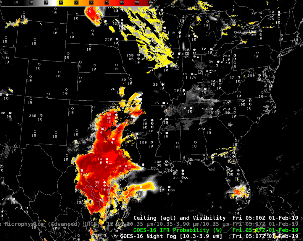
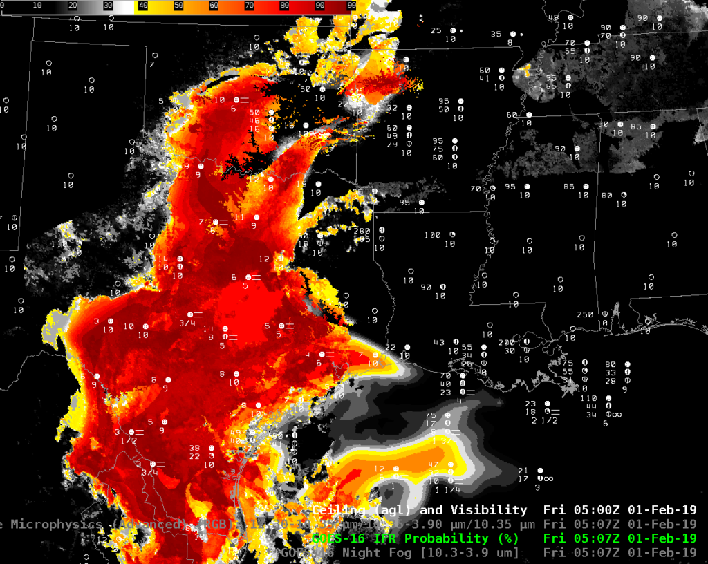
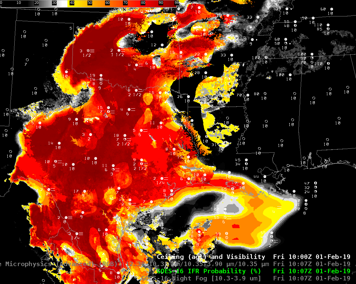
By merging satellite information about clouds and cloud type with Rapid Refresh model information at about low-level saturation, GOES-R IFR Probability fields screen out regions where IFR conditions are unlikely;  the map suggests low ceilings and fog are most likely over Texas and Oklahoma.  The zoomed in image, below shows that IFR conditions are indeed occurring in this region.  Other regions with a strong signal in the Brightness Temperature Difference field — Tennessee, for example — show low IFR Probability and surface observations that do not show IFR conditions.

GOES-R IFR Probability field, 0507 UTC on 1 February, along with surface reports of ceilings and visibility (Click to enlarge)

GOES-R IFR Probability field, 0507 UTC on 1 February, along with surface reports of ceilings and visibility zoomed in over the southern Plains (Click to enlarge)

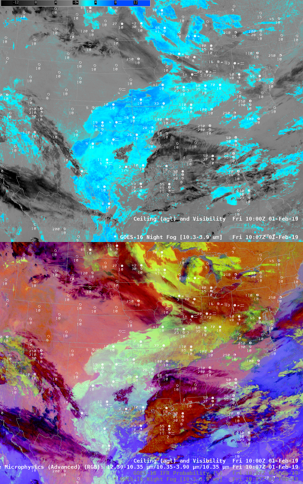
Night Fog Brightness Temperature Difference (10.3 µm – 3.9 µm) and Nighttime Microphysics RGB at 1007 UTC on 1 February 2019, and surface observations of ceilings and visibilities (Click to enlarge)

The same relationships occur at 1007 UTC; the Night Fog Brightness Temperature Difference and Nighttime Microphysics RGB overpredict the regions of low clouds/fog; IFR Probability’s use of Rapid Refresh Data allows it to screen out regions where fog is not present, but stratus clouds are, and also add in regions where cirrus clouds prevent the detection of low clouds, but Rapid Refresh data suggests low-level saturation is present (such as over the Gulf of Mexico south of Louisiana).

The IFR Probability field is accurately outlining the region of IFR conditions.

GOES-R IFR Probability field, 1007 UTC on 1 February, along with surface reports of ceilings and visibility (Click to enlarge)

GOES-R IFR Probability field, 1007 UTC on 1 February, along with surface reports of ceilings and visibility zoomed in over the southern Plains (Click to enlarge)

IFR Probability discriminates between fog and elevated stratus over Texas

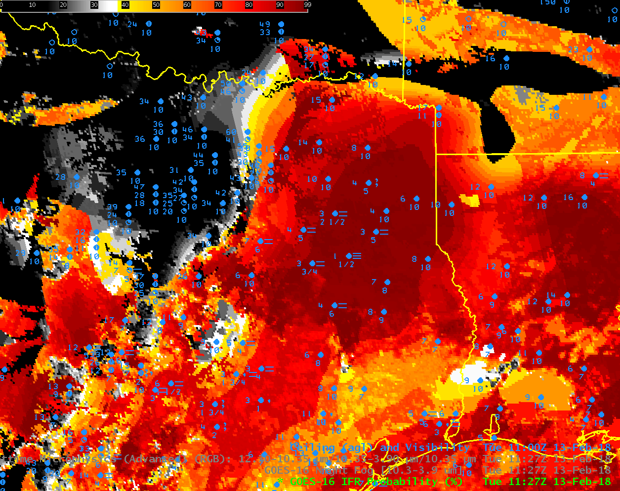
GOES-16 IFR Probability field, 1127 UTC on 13 February, along with observations of ceilings and visibility. (Click to enlarge)

GOES-16 IFR Probability fields on 13 February at 1127 UTC, above, suggest a clear difference in sky conditions between northeast Texas, where IFR Probabilities are very high, and where IFR conditions are widespread, and north-central Texas, around Dallas, where IFR Probabilities are small, and where ceilings and visibilities do not match IFR Conditions.

In contrast, the Brightness Temperature Difference field, below, (and the Nighttime Microphysics Red/Green/Blue product, shown here in a toggle with the Brightness Temperature Difference field) shows little difference in signal between the region of IFR conditions over northeast Texas and non-IFR conditions over Dallas and environs.

GOES-16 views the top of the cloud, and a region of fog and a region of stratus can look very similar in the Night Fog Brightness Temperature Difference. Because IFR Probability fields fuse satellite observations of low clouds with Numerical Model Output estimates of near-surface saturation, IFR Probabilities can differentiate between regions of elevated stratus (where near-surface saturation is not suggested by the model), such as near Dallas, and regions of stratus that is obstructing visibility (where near-surface saturation is suggested by the model).

A toggle of all three fields is shown at the bottom of this post.

GOES-16 Night Fog Brightness Temperature Difference (10.3 µm – 3.9 µm), 1127 UTC on 13 February 2018 (Click to enlarge)

GOES-16 IFR Probabilities, Night Fog Brightness Temperature Difference (10.3 µm – 3.9 µm) and NightTime Advanced Microphysics RGB, 1127 UTC on 13 February 2018 (Click to enlarge)

Dense Fog over the Texas High Plains

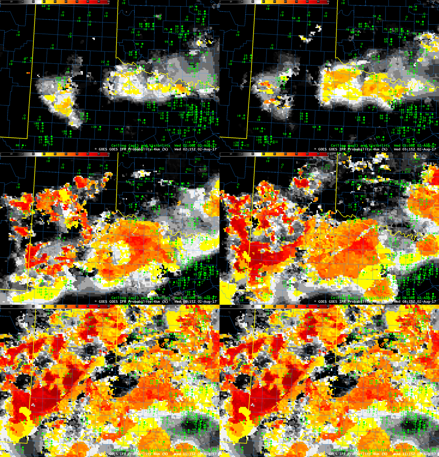
GOES-R IFR Probability fields, hourly from 0215-1115 UTC on 2 August 2017 (Click to enlarge)

GOES-R IFR Probabilities are computed using Legacy GOES (GOES-13 and GOES-15) and Rapid Refresh model information; GOES-16 data will be incorporated into the IFR Probability algorithm in late 2017

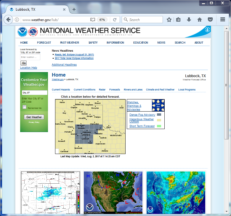
The National Weather Service in Lubbock issued Dense Fog Advisories (below) for parts of their CWA early in the morning on 2 August 2017.  GOES-R IFR Probability fields, above, show a slow increase in values over west Texas during the night of 1-2 August 2017, as visibilities drop and ceilings lower in the region.  This followed a band of showers that moved through the area around sunset on 1 August (Click here for a visible image from 0017 UTC on 2 August, from this site).  Highest IFR Probability values at the end of the animation generally overlay the Dense Fog Advisory.  As a situational awareness tool for the developing fog/low stratus, IFR Probability performed well.


GOES-16 data posted on this page are preliminary, non-operational and are undergoing testing

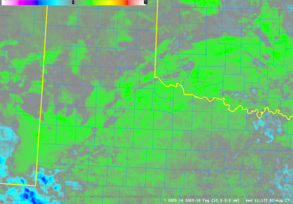
GOES-16 Brightness Temperature Difference field (10.3 µm – 3.9 µm) at 1117 UTC on 2 August 2017 (Click to enlarge)

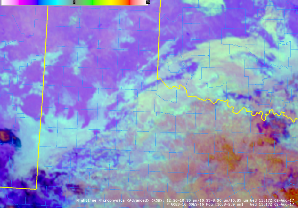
The GOES-R IFR Probability fields above mostly show the small-scale variability (i.e., pixelation) that is common when both (legacy) GOES data and Rapid Refresh Data are used to produce a probability that IFR conditions will be present.  Some exceptions:  southeastern New Mexico at the end of animation (1115 UTC);  the yellow and orange region there overlain by mid-level or high clouds that prevent a satellite view of the low clouds.  The GOES-16 Brightness Temperature Difference (10.3 µm – 3.9 µm) field at 1117 UTC shows a signal of high clouds there (cyan / blue / purple enhancement showing negative values that typify thin cirrus in the Brightness Temperature Difference field at night).  The Green values in the color enhancement are positive values and correspond to stratus (composed of water droplets) clouds.  Because the Brightness Temperature Difference field shows a signal, the Advanced Nighttime Microphysics RGB will also have a signal for fog (the whitish/cyan color), as shown below.

GOES-16’s better temporal and spatial resolution allow for more accurate monitoring of the development of small-scale features.  However, the shortcomings of using a Brightness Temperature Difference from satellite to monitor fog development should not be forgotten:  In regions of cirrus, satellite views of low stratus and fog are blocked.  In addition, over Texas and the rest of the High Plains, upslope flow can generate stratus over the central Plains that becomes fog over the High Plains as the terrain rises into the clouds.  The top of the stratus cloud and the fog bank in such a case can look very similar from satellite.

Advanced Microphysics RGB Composite at 1117 UTC on 2 August 2017 (Click to enlarge)

Below is a toggle between the 1115 UTC IFR Probability field, the GOES16 Brightness Temperature Difference Field, and the GOES16 Advanced Microphysics RGB Composite.

GOES-R IFR Probability fields computed with legacy GOES data and Rapid Refresh model output, GOES-16 Brightness Temperature Difference (10.3 µm – 3.9 µm) field and GOES-16 Advanced Microphysics RGB, all near 1115 UTC on 2 August 2017 (Click to enlarge)


Dense Fog Advisories along the western Gulf Coast

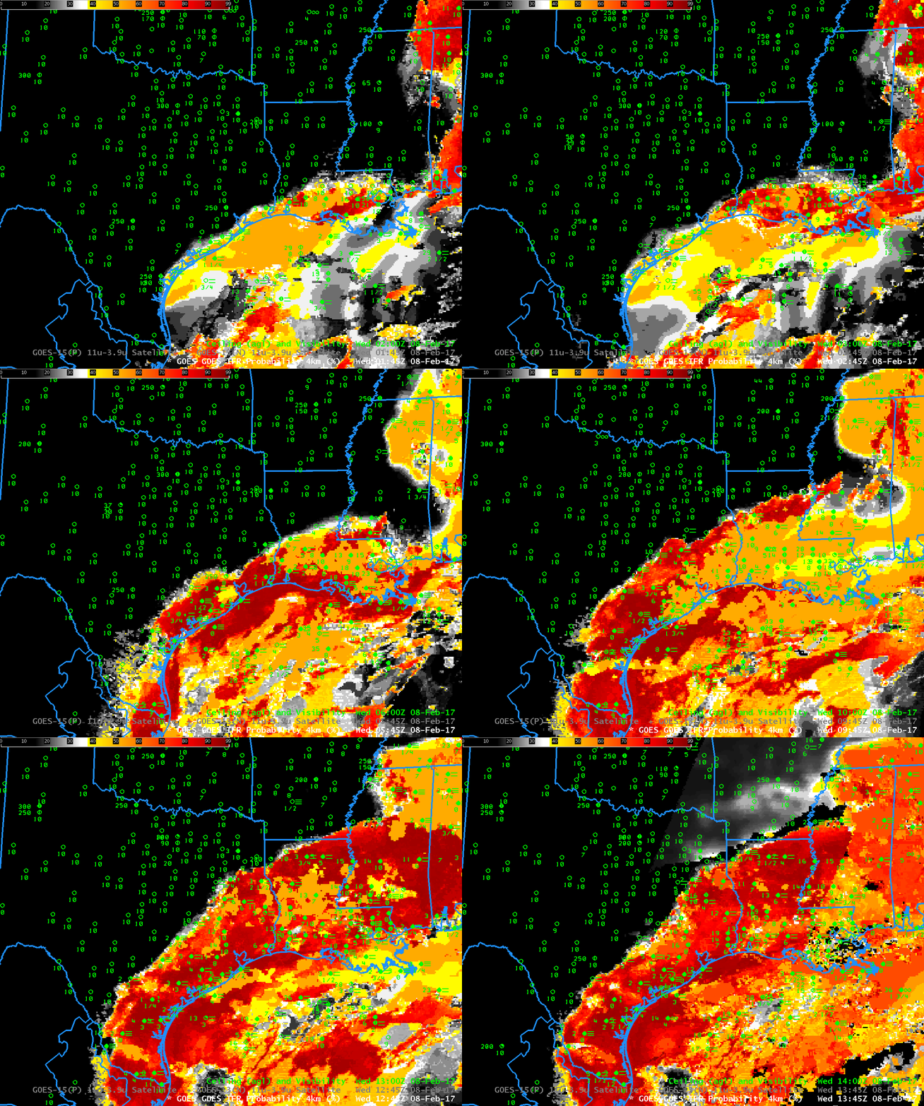
GOES-R IFR Probability fields, hourly from 0145-1345 UTC on 08 February 2017, along with surface observations of visibility and ceiling height (Click to enlarge)

Dense Fog developed along the western Gulf Coast early on the morning of 8 February 2017, leading to the issuance of Dense Fog Advisories (graphic from this site) and of IFR Conditions (graphic from this site).  The animation above shows the expansion of the field of high IFR Probabilities northwestward from the Gulf of Mexico starting at 0145 UTC.  IFR Conditions reported in concert with the arrival of higher IFR probabilities.  Relatively high IFR Probability values also develop over northern MIssissippi and Alabama.

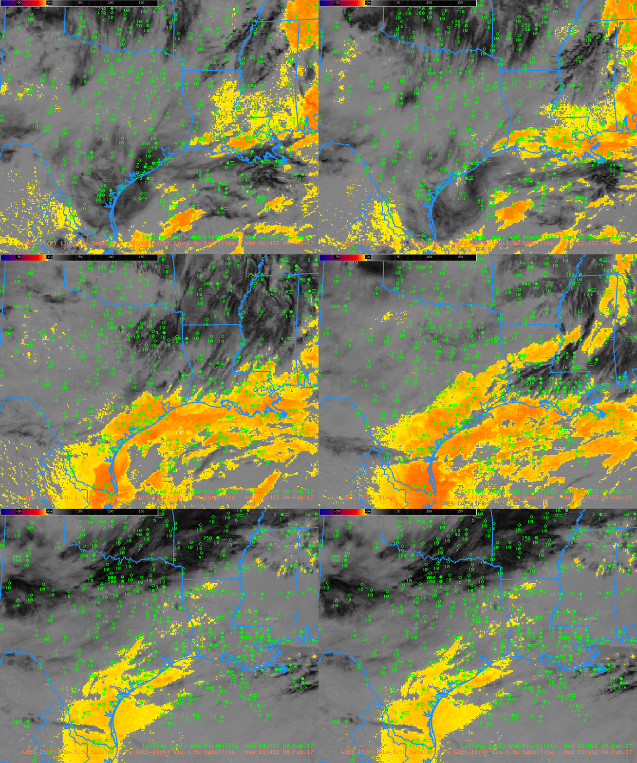
The traditional method of detecting low clouds at night, the brightness temperature difference field computed using brightness temperatures at 3.9 µm and 10.7 µm detects water-based clouds because of the different emissivity properties of the water-based cloud at those two wavelengths.  If ice clouds (at high levels) or mixed phase clouds (at mid-levels) exist, however, the satellite cannot view the low clouds.  This was the case on 8 February over northern Mississippi and northern Alabama, and also occasionally over Louisiana and Texas.  The toggle below from 0945 UTC, between the GOES-R IFR Probability field and the Brightness Temperature Difference field, shows several regions where Brightness Temperature Difference field enhancements do not indicate low clouds (over northwestern Mississippi, for example); in these regions, IFR Probabilities are nevertheless large because Rapid Refresh model data shows saturation in the lowest 1000 feet of the atmosphere, strongly suggestive of high IFR Probabilities, and that predictor serves to increase the value of the IFR Probability. The animation of the Brightness Temperature Difference fields is at the bottom of this blog post; compare it to the IFR Probability fields at the top. The IFR Probability algorithm capably fills in regions under high clouds/mid-level clouds where the satellite cannot view low clouds.  It gives a more consistent (and more accurate) depiction of the spread of the low clouds/fog.

Brightness Temperature Difference (3.9 µm – 10.7 µm) and GOES-R IFR probability at 0945 UTC on 8 February 2017 (Click to enlarge)

Another difficulty with Brightness Temperature Difference fields occurs around sunrise when increasing amounts of reflected solar radiation at 3.9 µm cause a sign change in the brightness temperature difference field (reflected 3.9 µm radiation increases as the sun rises and the computed brightness temperature therefore changes because reflected solar radiation at 10.7 µm is minimal;  emissivity-related differences between the two bands are overwhelmed).  The toggle below compares 1245 UTC and 1345 UTC Brightness Temperature Values.

Brightness Temperature Difference (3.9 µm – 10.7 µm) at 1245 and 1345 UTC on 8 February 2017 (Click to enlarge). Decreases in the brightness temperature differences occur at 1345 UTC because of increases in reflected solar radiation at 3.9 µm.

Brightness Temperature Difference (3.9 µm – 10.7 µm), 0145 – 1345 UTC on 8 February 2017, along with surface observations of ceilings and visibility (Click to enlarge)