Category Archives: Error Explanations

IFR Probability fields in extreme cold

GOES_IFR_11-3_20131226_1800toggle

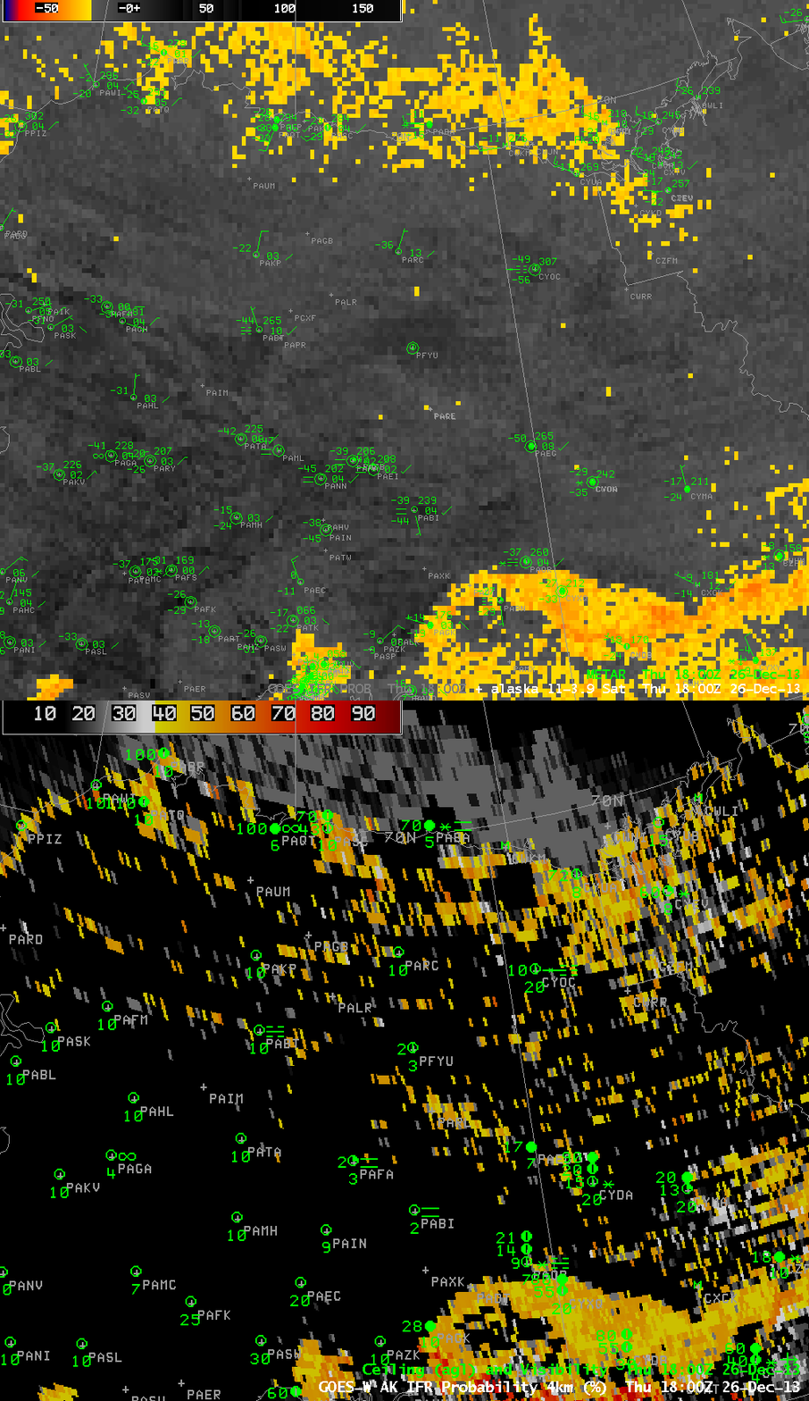
GOES-R IFR Probabilities from GOES-15 with surface ceilings/visibilities and GOES-15 Brightness Temperature Difference (10.7 µm – 3.9 µm) Fields with surface plots at 1800 UTC 26 December 2013 (click image to enlarge)

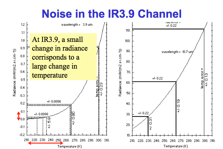
The image toggle above shows IFR Probability and the Brightness Temperature Difference Field over northern Alaska. Plotted METAR observations show very cold surface temperatures in the -30 to -50 F range. At such cold temperatures, the pseudo-emissivity computation can become noisy because a very small change in 10.7 µm radiance (used to compute the 3.9 µm radiance) can cause a large change in 3.9 µm brightness temperature. (The effect is shown graphically below — a small change in radiance at 3.9 µm leads to a very large temperature change). This noise can lead to a speckled appearance to the IFR probability fields. This effect can also occur in the northern Plains of the United States when surface temperatures dip below zero.

Noise_in_3.9um_ch

Radiance (y-axis) vs. Brightness Temperature (x-axis) for 3.8 µm (left) and 10.7 µm (right)

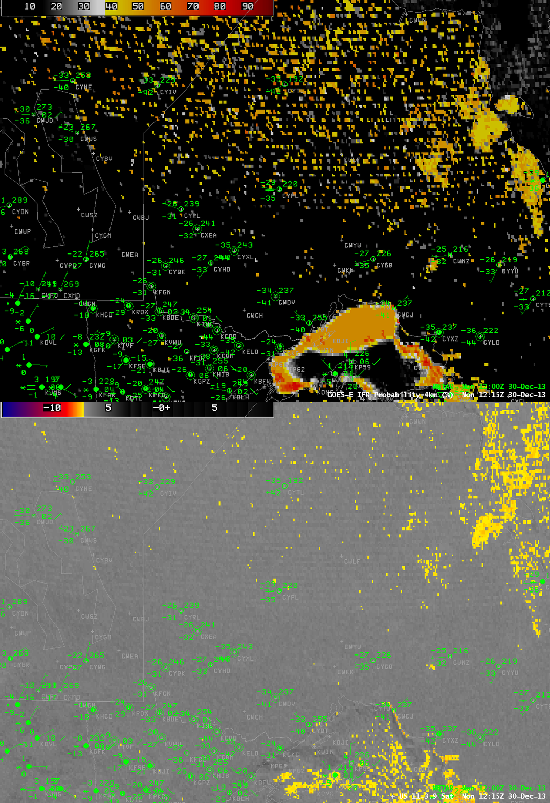
(update) Below is the IFR Probability in the heart of a Polar Airmass over northwestern Ontario.

GOES_IFR_11-3.9_20131230_1215

GOES-R IFR Probabilities from GOES-13 with surface ceilings/visibilities and GOES-13 Brightness Temperature Difference (10.7 µm – 3.9 µm) Fields with METAR plots at 1215 UTC 29 December 2013 (click image to enlarge)

Advection Fog over the Upper Midwest

GOES_BTD_IFR_PROB_20131204_0215

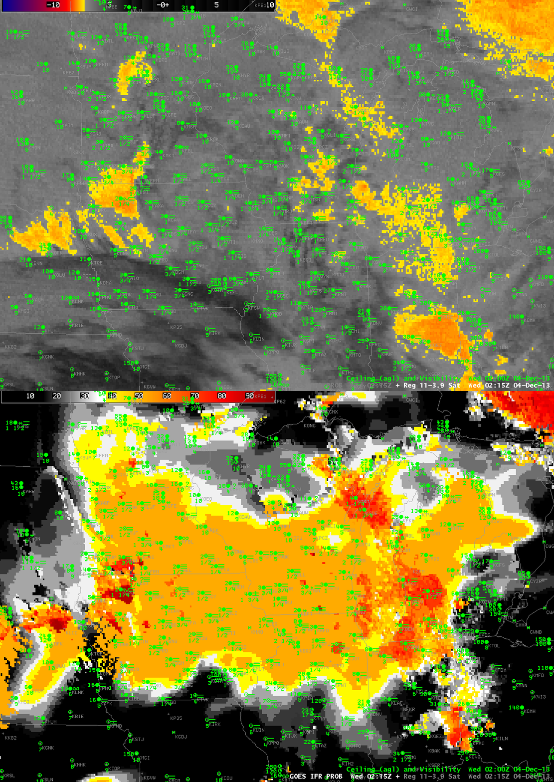
Toggle between nighttime GOES-R IFR Probabilities from GOES-13 and GOES-13 Brightness Temperature Differences (10.7 µm – 3.9 µm) at 0215 UTC on 4 December 2013 (click image to enlarge)

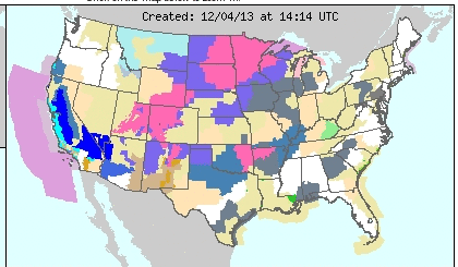
Dense advection fog developed in the upper midwest on Tuesday 3 December 2013 and persisted into December 4th as a Colorado Cyclone moved into central Wisconsin, drawing moist air over cold ground. The IFR Probability Product, a product that fuses together the 3.9 µm pseudo-emissivity (nighttime only) from satellites (a signal similar to the 3.9-11 µm brightness temperature difference field, which gives little information on low clouds in this situation) with model data from the Rapid Refresh (which suggests widespread fog), accurately depicts the large region of advection fog that led to dense fog advisories over parts of Wisconsin and Iowa and surrounding states (see below).

crh_crop

Cropped Screenshot from http://www.crh.noaa.gov at 1414 UTC on 4 December 2013 that shows widespread Dense Fog Advisories over the Upper Midwest

GOES_IFR_PROB_20131203_2145

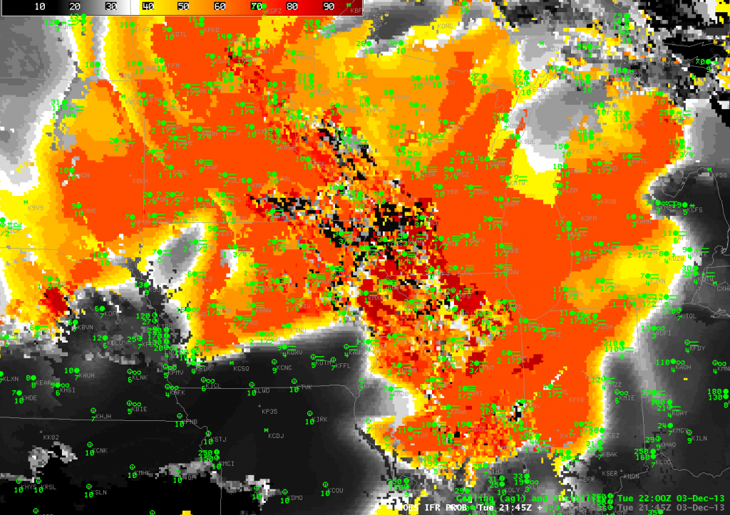
Daytime GOES-R IFR Probabilities computed from GOES-13, 2145 UTC on 3 December 2013 (click image to enlarge)

The dense fog was present late in the day on December 3rd, 2013, and the IFR Probability fields reflected that. However, in the image above, there are isolated pixels with very low probabilities mixed in with the high probabilities over Wisconsin and surrounding states where advection fog was widespread. Why?

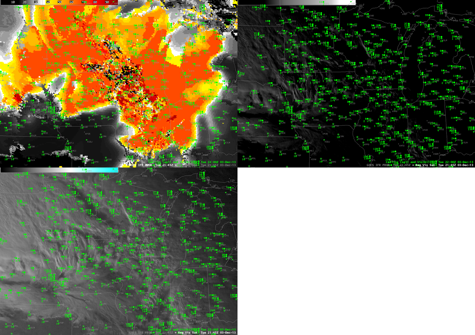
This storm had multiple cloud layers, which can make detection of low cloud difficult from satellite (above) when sun angles are low (sunrise/sunset). The IFR Probability image above is at 3:45 PM local time, and the sun is low in the sky. Deep shadows are being cast and the dark shadowed regions in the visible are misinterpreted by the cloud-clearing algorithm as clear skies. During the day the GOES-R fog/low stratus algorithm relies on the cloud mask to determine where clouds are. Where clear skies are detected (erroneously, in this case), IFR Probabilities are not calculated because fog/low stratus are not expected to be present. Thus, if you see pixelated fields such as the one above, and the sun is low in the sky, this likely means cloud shadows are causing the cloud mask to erroneously return clear sky, which in turn leads to very low IFR probabilities. The animation below cycles through IFR Probability and visible imagery (with a regular enhancement and with a low-light enhancement). After sunset, the cloud shadows are gone and the probability field fills in (as can be seen in the 0215 UTC imagery at the top of this post).

GOES_IFR_PROB_and_Vis_Sat_20131203_2145

Daytime GOES-R IFR Probabilities computed from GOES-13 at 2145 UTC on 3 December 2013 and the corresponding Visible Imagery  (click image to enlarge)

A Reminder about Co-Registration Errors

GOES_IFR_PROB_20131127_745_802loop

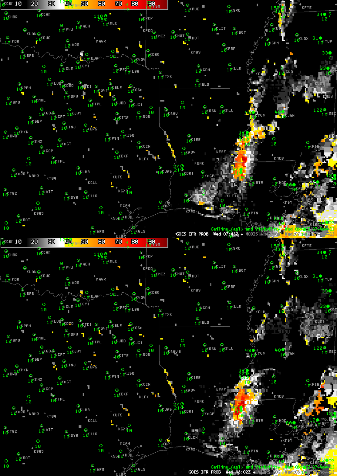
GOES-R IFR Probabilities from GOES-13, times as indicated on 27 November 2013 (click image to enlarge)

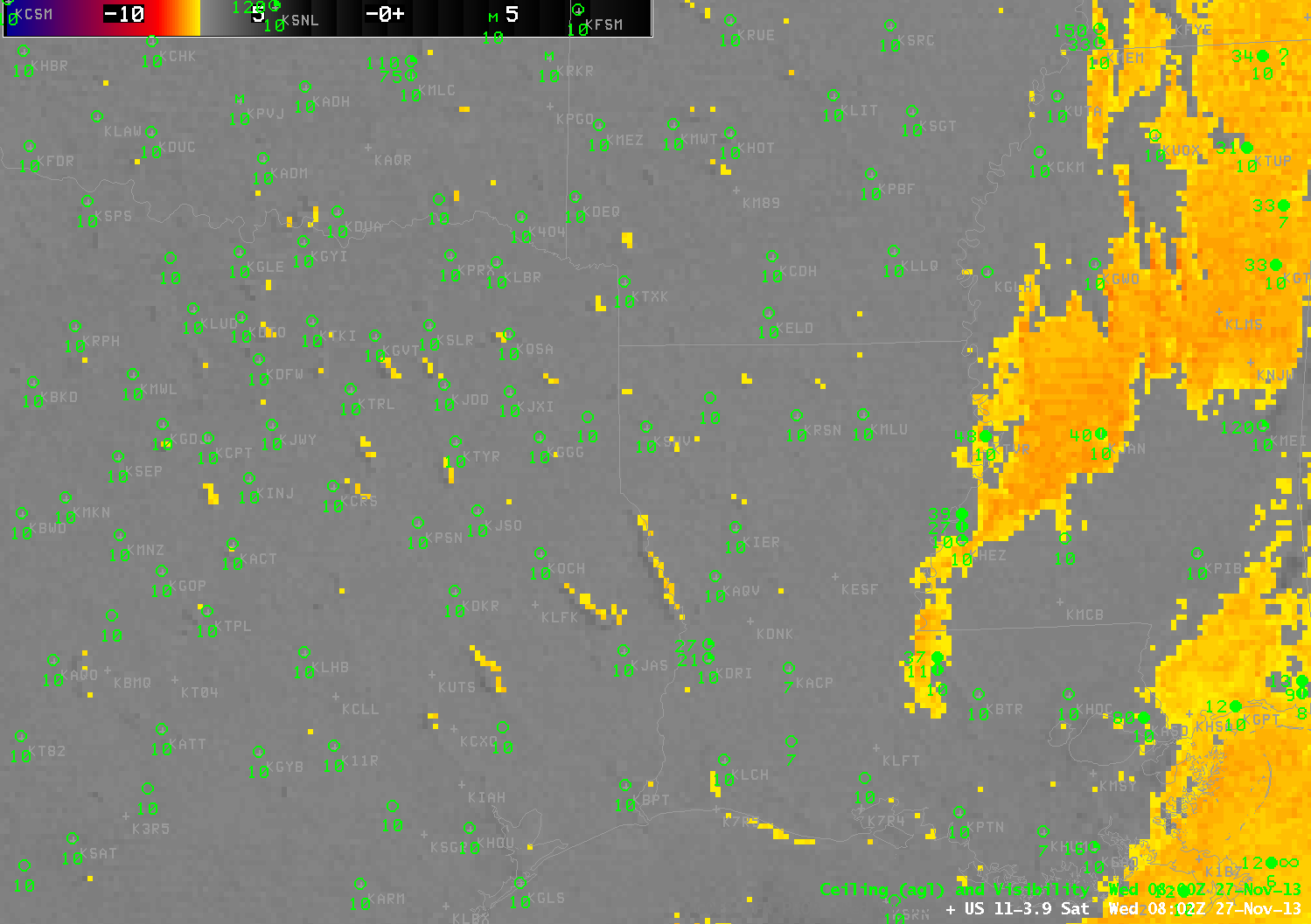
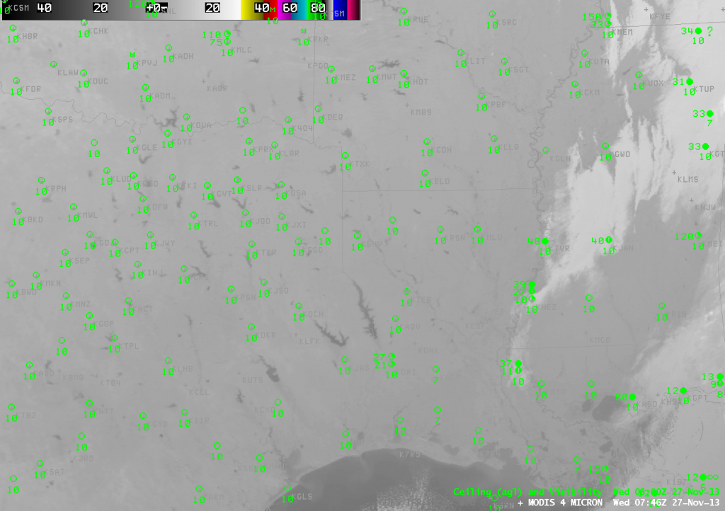
The GOES-R IFR Probability field showed enhanced probabilities surrounding lakes and rivers in Louisiana and Texas overnight. This is in large part due to a strong signal in the Brightness Temperature Difference field. There is a co-registration error between the 10.7 µm and 3.9 µm detectors on the GOES Imager. This means that the pixel locations for the two channels are not aligned, and at times the mis-alignment is large enough that a fog signal is produced. In the present case, one of the detectors sees the warm waters of a lake, and the second detector sees the adjacent (much cooler) shoreline, but the navigation misalignment is such that both pixels are believed to be co-located. Thus a difference in the brightness temperature occurs not because of emissivity difference properties in clouds (which also makes the 3.9 micron brightness temperature appear cooler) but because of a co-registration error. The brightness temperature difference field from 0802 UTC is below (the 0745 UTC image is very similar). Note how the enhanced brightness temperature difference field appears to have a shadow just to its west. It is possible for this to occur if a cloud is forming downwind of a warm lake. However, in the present case, winds were primarily northerly, not westerly.

US_11-3.9_Sat_20131127_0802

GOES-13 Brightness Temperature Difference Product (10.7 µm – 3.9 µm) 0802 UTC 27 November 2013 (click image to enlarge)

Polar Orbiting satellites viewed this region contemporaneously. Aqua, carrying the MODIS instrument, passed overhead at 0745 UTC, and Suomi/NPP at 0802. What did they see? The 3.9 µm channel from MODIS, below, highlights the warm lake waters over eastern Texas and Louisiana. There is little indication in this image of clouds near the lakes.

MODIS_4_MICRON_20131127_0746

MODIS Brightness temperature at ~3.9 µm 0802 UTC 27 November 2013 (click image to enlarge)

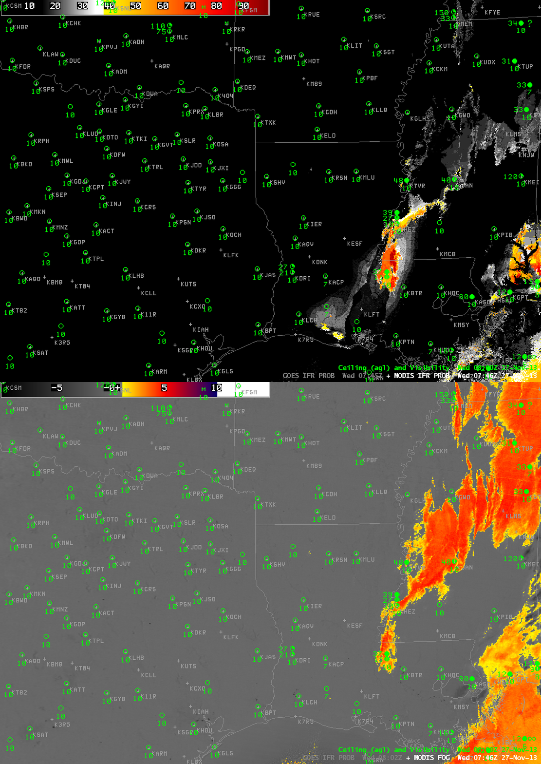
The brightness temperature difference product from MODIS, below, and the MODIS-based IFR Probabilities also show no indication of fog/low stratus near the bodies of water in east Texas/Louisiana.

MODIS_FOG_IFR_20131127_0746

MODIS Brightness temperature difference (11.0 µm – 3.9 µm) and MODIS-based IFR Probabilities at 0746 UTC 27 November 2013 (click image to enlarge)

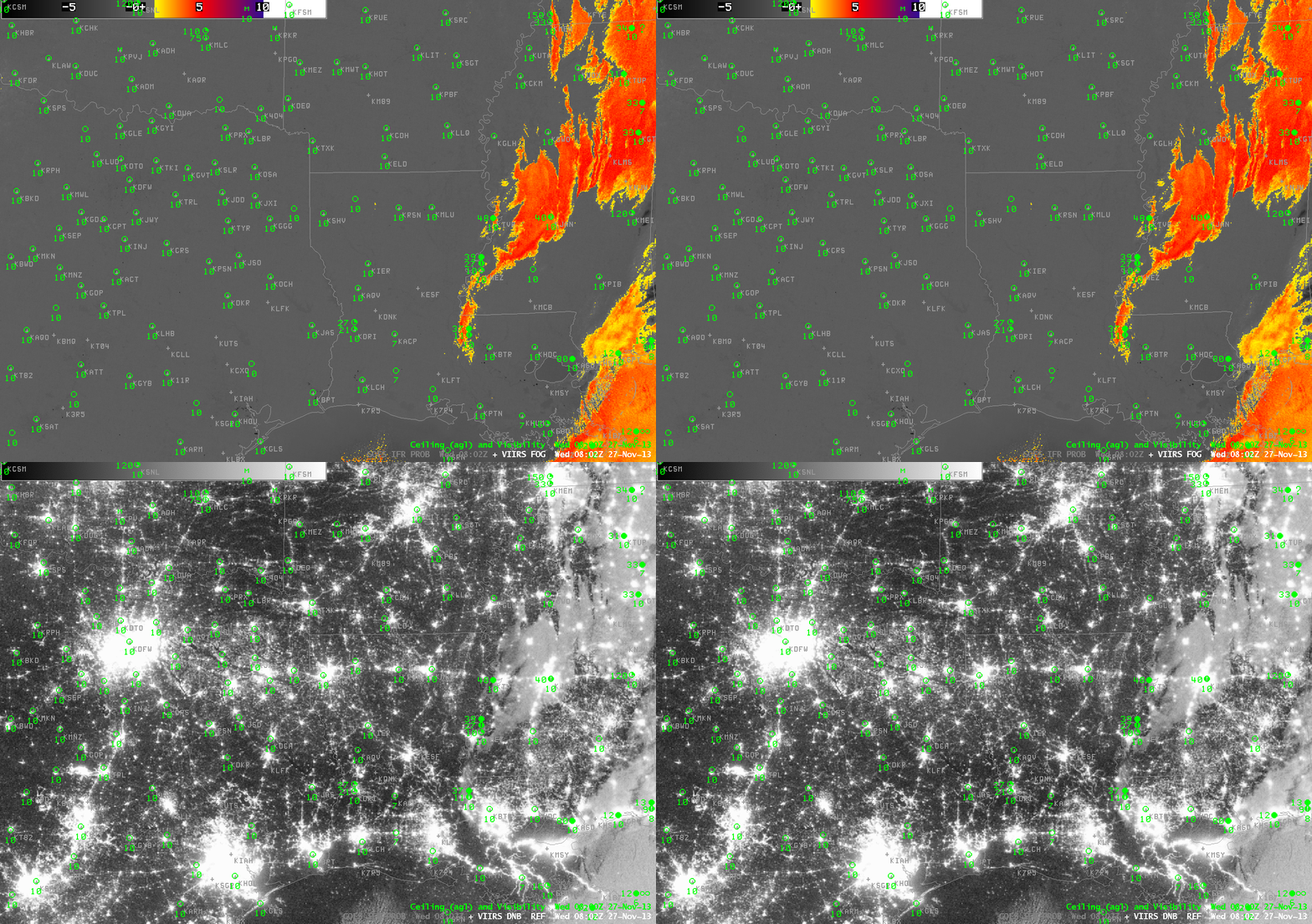
Suomi/NPP data are shown below. The Brightness Temperature Difference (10.35 µm – 3.74 µm) Field, the 3.74 µm field and the Day/Night band all are consistent with clear skies near the water bodies of east Texas and western Louisiana.

VIIRS_FOGDNB_20131127_0802

Suomi/NPP VIIRS Brightness Temperature Difference (10.35 µm – 3.74 µm) and Day/Night band at 0802 UTC 27 November 2013 (click image to enlarge)

Be cautious when interpreting the brightness temperature difference from GOES (and IFR Probabilities that are computed using the satellite signal) along land/water boundaries. GOES Engineers continue to investigate methods of mitigating this co-registration error.

Fog Development near Lake Michigan

GOES_IFR_PROB_20131010_0615

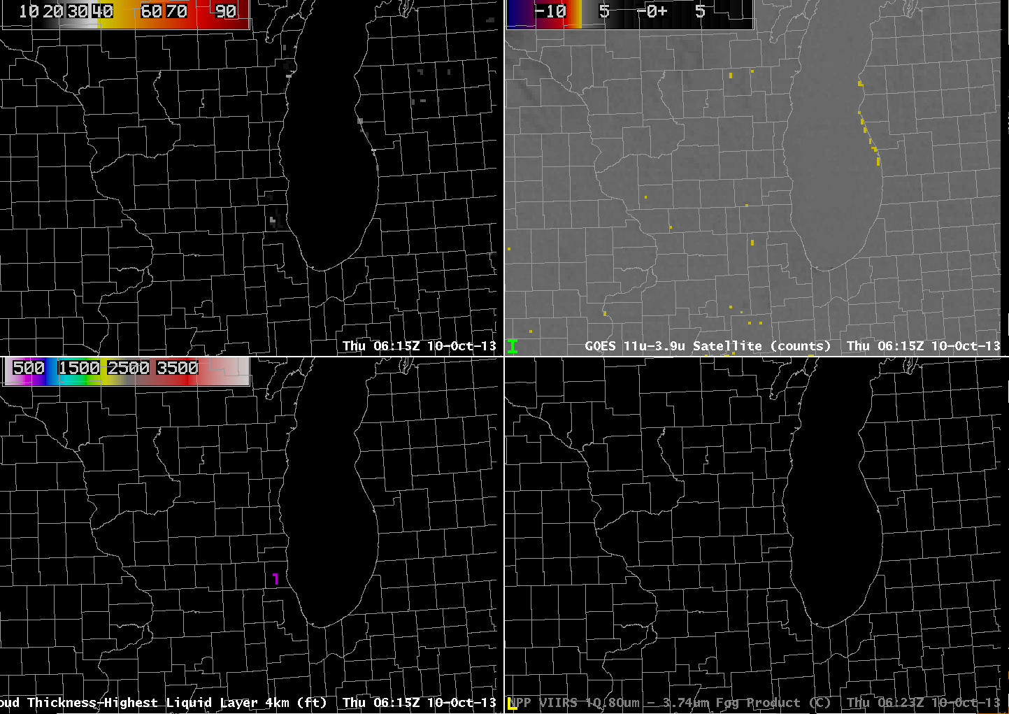
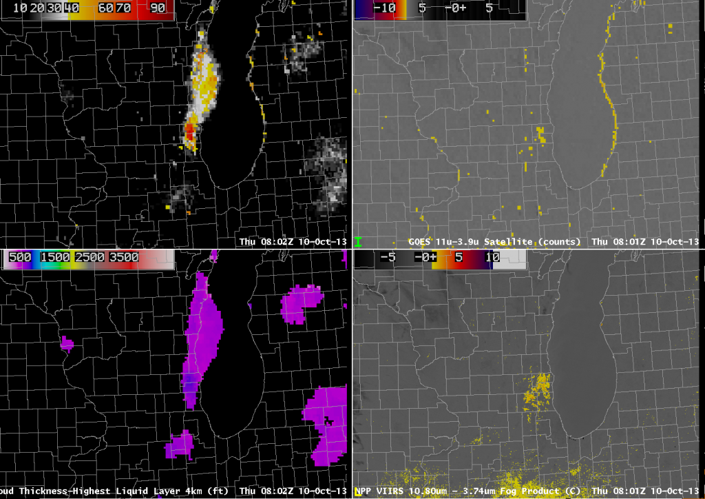
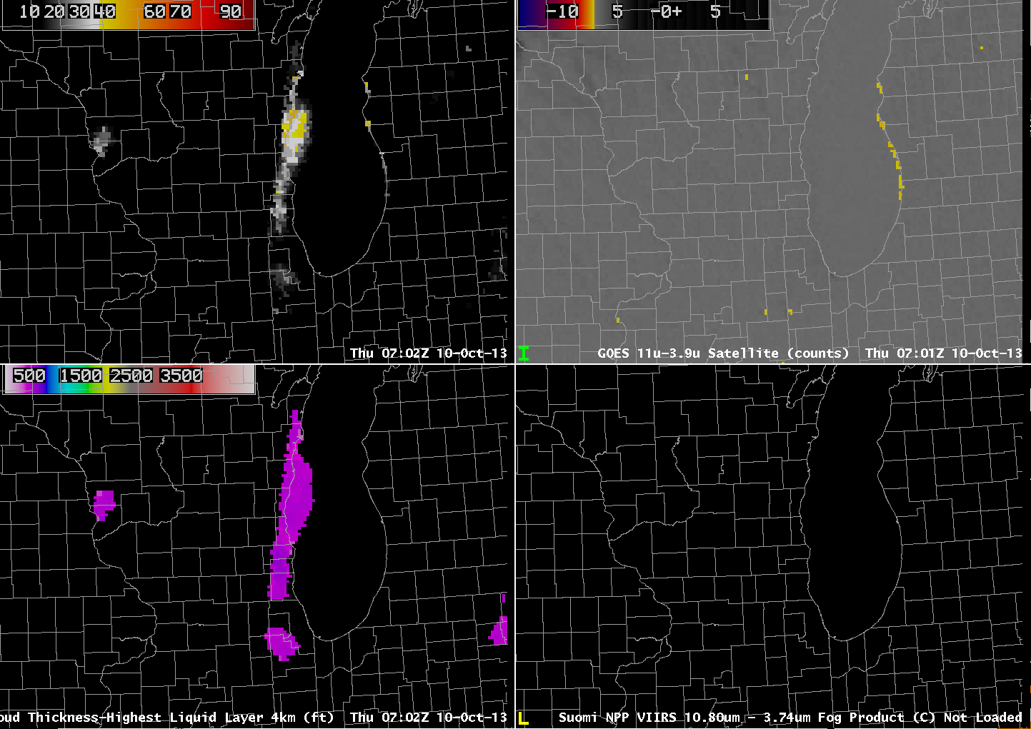
GOES-13-based GOES-R IFR Probabilities (Upper Left), GOES-13 Brightness Temperature Difference Product (10.7 µm – 3.9 µm) (Upper Right), GOES-13-based GOES-R Cloud Thickness (Lower Left), Suomi/NPP Brightness Temperature Difference (Lower Right), all near 0615 UTC on 10 October (click image to enlarge)

The GOES-R IFR Probability product gave useful advance warning to the development of fog near Lake Michigan’s eastern shore overnight. The image above, from 0615 UTC, shows a flat brightness temperature difference field over the lakeshore counties in Wisconsin and Illinois (values are from -7.1 to -7.3); there are two regions of high values in the IFR Probability field, however: Near Manitowoc WI (values up to 29%) and over southeast WI and northeast IL (values near 20%). So by 0615 UTC on 10 October, IFR Probabilities are suggestive of a nascent fog development.

GOES_IFR_PROB_20131010_0702

As above, but for 0702 UTC on 10 October (click image to enlarge)

Forty-five minutes later, at 0702 UTC (above), IFR Probabilities have increased dramatically in eastern WI even as the brightness temperature difference field remains flat. Thus, the Rapid Refresh Data is accurately capturing the development of low-level saturation in the atmosphere, and that is influencing the IFR probability field. In addition, the GOES-R Cloud Thickness field is suggesting that the cloud bank is 500-600 feet thick. The strip of enhanced brightness temperature difference paralleling the Lake Michigan shore in lower Michigan is an artifact of the co-registration error between the 10.7 µm and 3.9 µm band detectors on GOES-13. Between 0656 UTC and 0734 UTC, visibility at Manitowoc, WI (KMTW), dropped from 5 to 3/4 statute miles. The visibility at Burlington WI (KBUU) dropped from 4 to 1 statute miles between 0600 and 0700 UTC, and Waukegan, IL (KUGN) reported a visibility of 1/4 mile at 0552 UTC and 0652 UTC.

GOES_IFR_PROB_20131010_0802

As above, but for 0802 UTC on 10 October (click image to enlarge)

At 0802 UTC, the GOES-East brightness temperature difference field shows greater differences over the region of SE Wisconsin where the fog is developing. Accordingly, the IFR probability increases past 80% IFR Probabilities are near 70% in Manitowoc County (and Manitowoc reported 1/2-mile visibility at 0834 UTC). Compare the GOES-East and Suomi/NPP Brightness Temperature Difference Fields; note the lack of a signal in the Suomi/NPP field along the western shore of Lake Michigan, confirming the co-registration error present in GOES-13.

GOES_IFR_PROB_20131010_1145

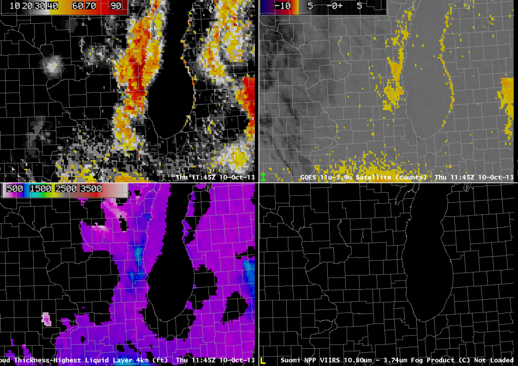
As above, but for 1145 UTC on 10 October (click image to enlarge)

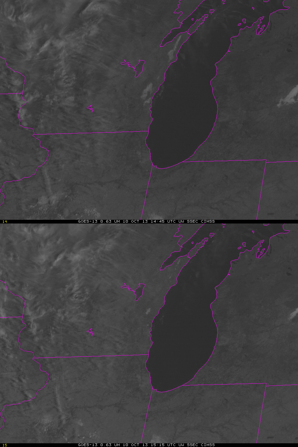
The last pre-sunrise image, 1145 UTC, shows a definite signal of fog/low stratus in both the IFR Probability field and in the Brightness Temperature Difference field. However, the early detection in the IFR Probability field gives a nice head’s up to the forecaster. Note also in this image how the strong signal in the brightness temperature difference field that arises because of the co-registration error can contaminate the IFR Probability field. The Cloud Thickness in this field has been related to dissipation time, as shown in this chart. The maximum thickness of 1000 feet predicts a dissipation time around 1500 UTC. The 1445 and 1515 UTC GOES-13 visible images are shown below.

GOES13_VIS_10Oct2013loop

GOES-13 Visible Imagery at 1445 UTC and 1515 UTC on 10 October (click image to enlarge)

Brightness Temperature Differences over the Rockies

GOESVIIRS_20130919_0930

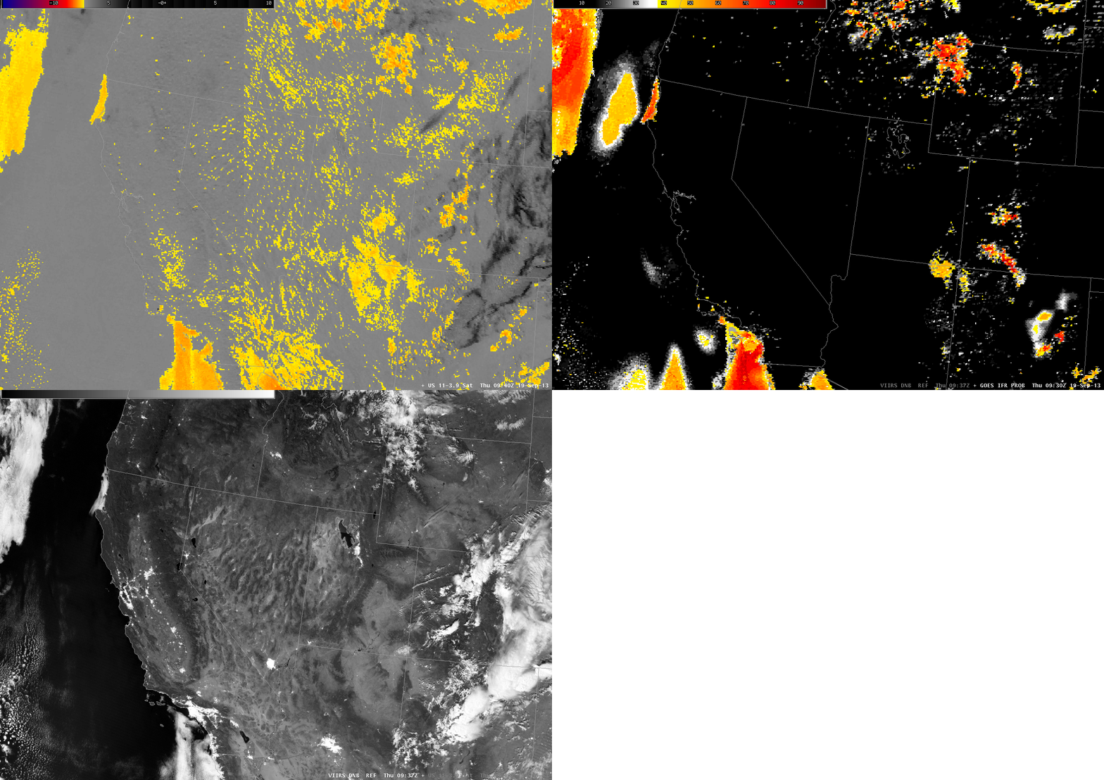
The heritage brightness temperature difference method of detecting fog/low stratus works because clouds that are comprised of liquid water droplets have different emissivity properties at 3.9 µm and at 10.7 µm. Clouds are not black-body emitters at 3.9 µm; they are more closely blackbody emitters at 10.7 µm. Consequently, the 3.9 µm radiance detected by the satellite suggests a cooler emitting blackbody temperature than the 10.7 µm radiance detected by the satellite. The difference between those two temperatures therefore highlights water-based clouds.

Some soils over the western US also have emissivity properties that are a function of wavelength such that the brightness temperature difference product will show a maximum in some regions but not in others. A careless interpretation of the brightness temperature difference signal, then, might lead to an erroneous assumption that fog/low clouds are present in a region of clear skies. The loop above shows the brightness temperature difference field at 0930 UTC on 19 September, and there are many regions with a signal that is consistent with fog/low clouds. The GOES-R IFR Probability algorithm correctly screens out many of these regions because the Rapid Refresh data does not predict low-level saturation. The day-night band image from Suomi/NPP can be used to verify where low clouds are present, and the image shows that most of the western US was clear. The IFR Probability field has false positives in 4 locations: extreme northeastern Arizona, Northwestern Mexico just to the east of the Colorado River, and two patches in the Pacific, one west of northern California, and one west of southern California.

Brightness Temperature Difference signals sometimes show positives over the central and eastern US in cases of extreme drought, as shown here.

GOES Resolution might miss valley fog (Plus: What does Stray Light look like?)

GOES_IFR_PROB_20130918_0615

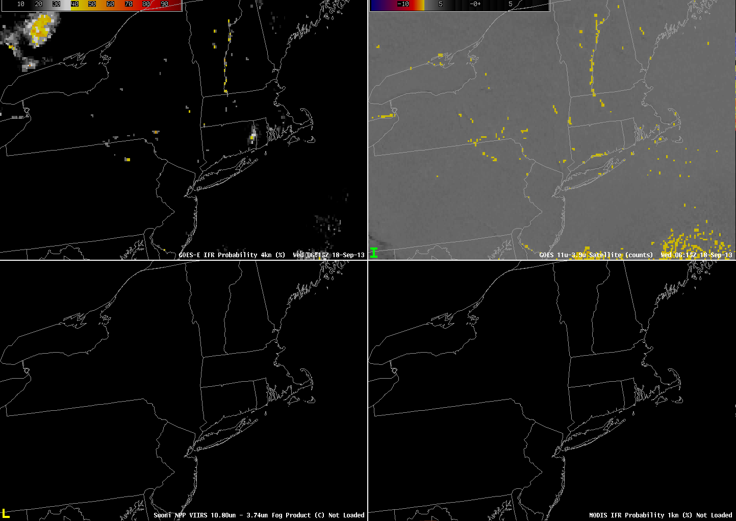
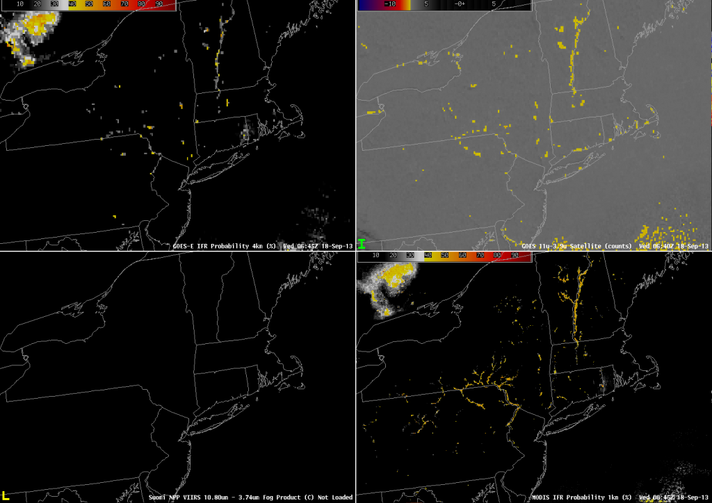
GOES-R IFR Probability (Upper Left), GOES-East Brightness Temperature Difference (Upper Right), Suomi/NPP Brightness Temperature Difference (Lower Left), MODIS-based IFR Probability (Lower Right), all imagery at 0615 UTC on 18 September 2013 (click image to enlarge)

Nominal GOES resolution for the Brightness Temperature Difference product that is used in the GOES-R IFR Probability is 4 km at the sub-satellite point, and it worsens as you move into mid-latitudes. Rapid Refresh Model resolution is even coarser than the satellite. When fog is forming in narrow valleys, then, there can be a significant lag in the time from when it starts to form to when the satellite data, and the satellite/model fused product, detects it. In the 0615 UTC image above, for example, only a few pixels of strong GOES-detected Brightness Temperature Difference, and enhanced IFR Probabilities, exist. In the 0630 UTC image, below, there has been little change in the GOES-based imagery. However, the Suomi/NPP data at the time, at 1-km resolution, suggests fog is forming in many of the river valleys of Pennsylvania, but it is still sub-gridscale as far as GOES can detect.
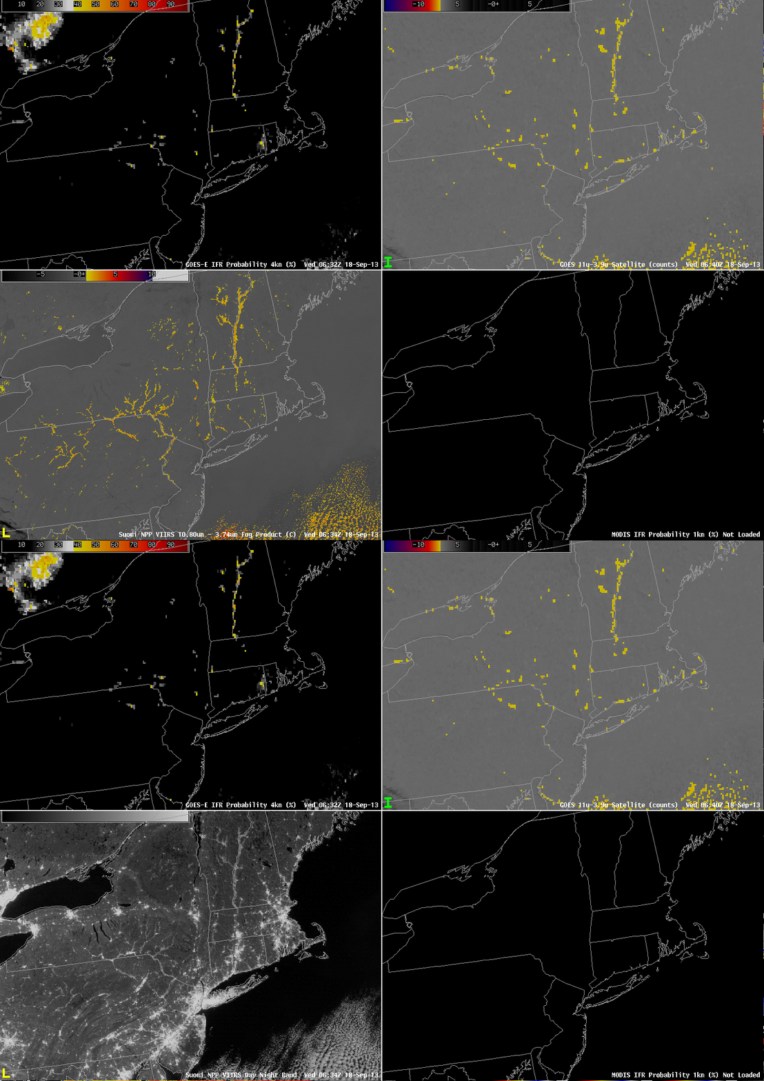
VIIRS_DNBBTD_20130918_0634loop

GOES-R IFR Probability (Upper Left), GOES-East Brightness Temperature Difference (Upper Right), Toggle between Suomi/NPP Day/Night band imagery and Suomi/NPP Brightness Temperature Difference (Lower Left), MODIS-based IFR Probability (Lower Right), all imagery at ~0630 UTC on 18 September 2013 (click image to enlarge)
GOES_IFR_PROB_20130918_0645

GOES-R IFR Probability (Upper Left), GOES-East Brightness Temperature Difference (Upper Right), Suomi/NPP Brightness Temperature Difference (Lower Left), MODIS-based IFR Probability (Lower Right), all imagery at 0645 UTC on 18 September 2013 (click image to enlarge)

Fifteen minutes later, the MODIS-based IFR probabilities (above) suggest a strong possibility of IFR conditions in many of the river valleys of Pennsylvania. However, Suomi/NPP and MODIS data come from polar orbiters so that high resolution information is infrequent. When GOES-R is launched, ABI will have nominal 2-km resolution in the infrared, which resolution is intermediate between GOES and MODIS.

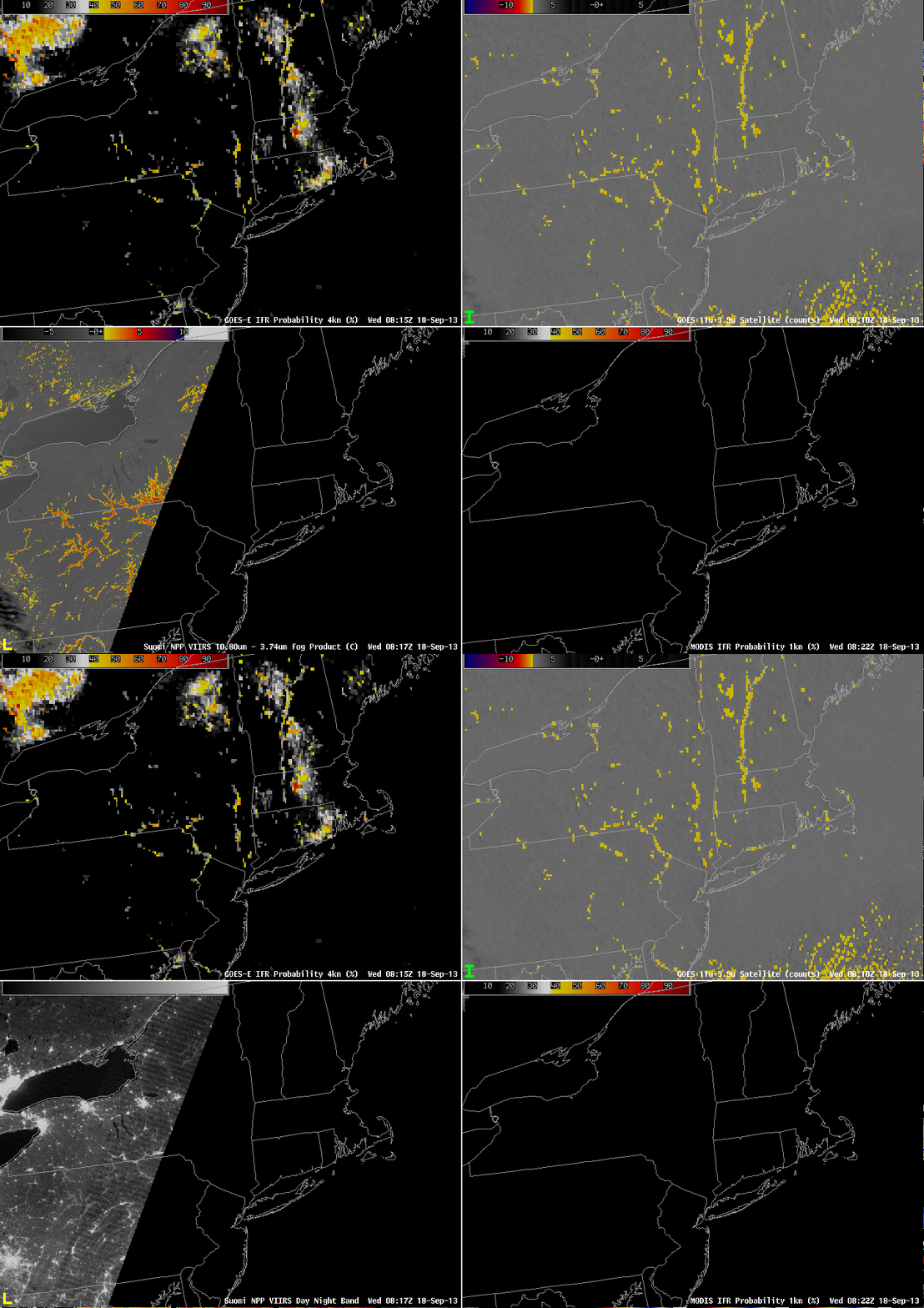
The higher-resolution polar orbiters’ occasional views can give a forecaster an important heads’ up for fog formation. By 0815 UTC the GOES-based information is showing higher IFR probabilities in the river valleys of Pennsylvania, but a Suomi/NPP overpass shows that it is still underestimating the areal extent of the fog.
VIIRS_DNBBTD_20130918_0817loop

GOES-R IFR Probability (Upper Left), GOES-East Brightness Temperature Difference (Upper Right), Toggle between Suomi/NPP Day/Night band imagery and Suomi/NPP Brightness Temperature Difference (Lower Left), MODIS-based IFR Probability (Lower Right), all imagery at ~0815 UTC on 18 September 2013 (click image to enlarge)

Note that this is a time of year when stray light does occasionally enter the GOES signal, causing contamination. This occurred — and was very obvious — around 0400 UTC on 18 September. As is typical, it was present for only one scan. See below.

GOES_CLD_THICK_20130918loop

GOES-R IFR Probability (Upper Left), GOES-East Brightness Temperature Difference (Upper Right), GOES-R Cloud Thickness (Lower Left), MODIS-based IFR Probability (Lower Right), all imagery at ~0815 UTC on 18 September 2013 (click image to enlarge)
GOES-15 Navigation Anomalies

GOES_CLD_THICK_20130910navloop

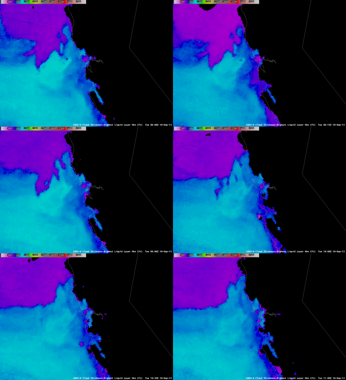
GOES-R IFR Cloud Thickness computed from GOES-West and Rapid Refresh data (click image to enlarge)
For the past 3 mornings (8, 9 and 10 September) GOES-15 Navigation has suffered an anomaly around 0930 UTC. The animation above shows the effects: Cloud Thickness fields (and IFR probability fields, not shown) are shifted. Click here for more information. The navigation anomalies typically end around 1030 UTC.

Co-registration errors on GOES-14

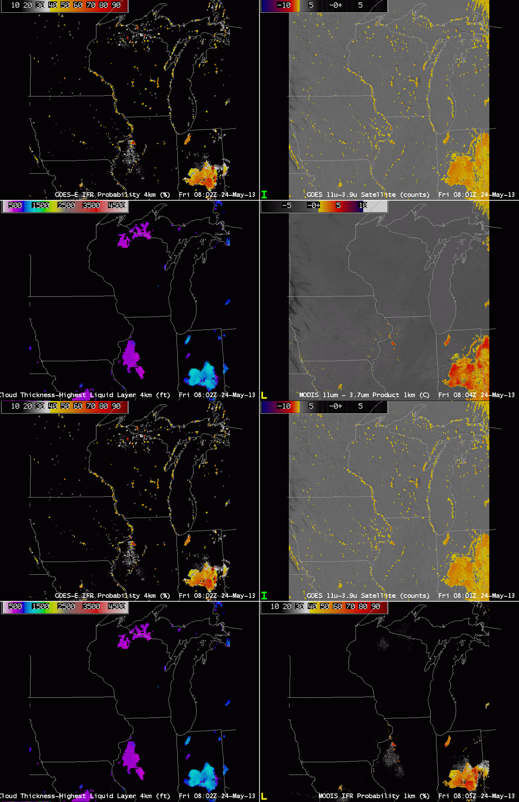
GOES-R IFR Probabilities computed from GOES-14 (Upper Left), GOES-14 Brightness Temperature Difference (10.7 µm – 3.9 µm) (Upper Right), GOES-R Cloud Thickness (Lower Left), Toggle between MODIS brightness temperature difference (11 µm – 3.7 µm) and GOES-R IFR Probabilities computed from MODIS (Lower Right)

GOES-13 has a co-registration error between the 10.7 and 3.9 µm channel.  That is, the two different channels do not view the same identical pixel.  There is expected to be some variance (at the sub-pixel scale), but the differences exceed system specifications.  This error is also present in GOES-14, as shown above.  The brightness temperature difference product from GOES-14 (upper right) erroneously depicts the presence of Fog/Low Stratus along the western shores of Lakes Michigan and Winnebago and others, and along the various river valleys.  A MODIS image at the same time does not indicate low clouds at all.  The GOES imagery suggests clouds because of the coregistration error:  one channel sees the water and one sees the land, so the difference is actually a land-sea temperature difference rather than one due to emissivity differences between the two wavelengths for water clouds.

The error in GOES propagates into the GOES-R IFR probability fields as a thread of higher probability paralleling the water.  Cloud Thickness fields do not show the signal, however.

This example shows the benefit of using two different satellites to view the same scene.  An misalignment in one typically is not present in the second.

Small IFR Probabilities in clear regions: Why?

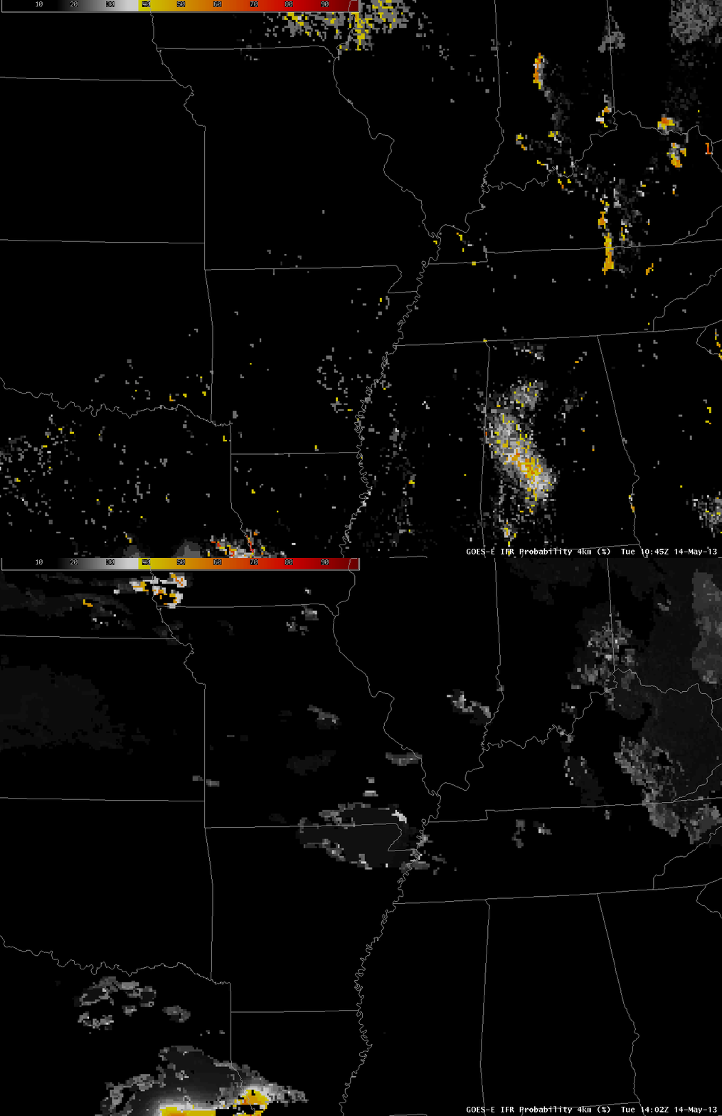
GOES-R IFR Probabilities over the Mississippi River Valley, 1045 and 1402 UTC 14 May 2013

GOES-R IFR Probabilities over the bootheel of Missouri and northeast Arkansas were erroneously high on Tuesday 14 May (and also on Monday 13 May).  This was a region of mostly clear skies.  Why, then did IFR probabilities have values exceeding zero?

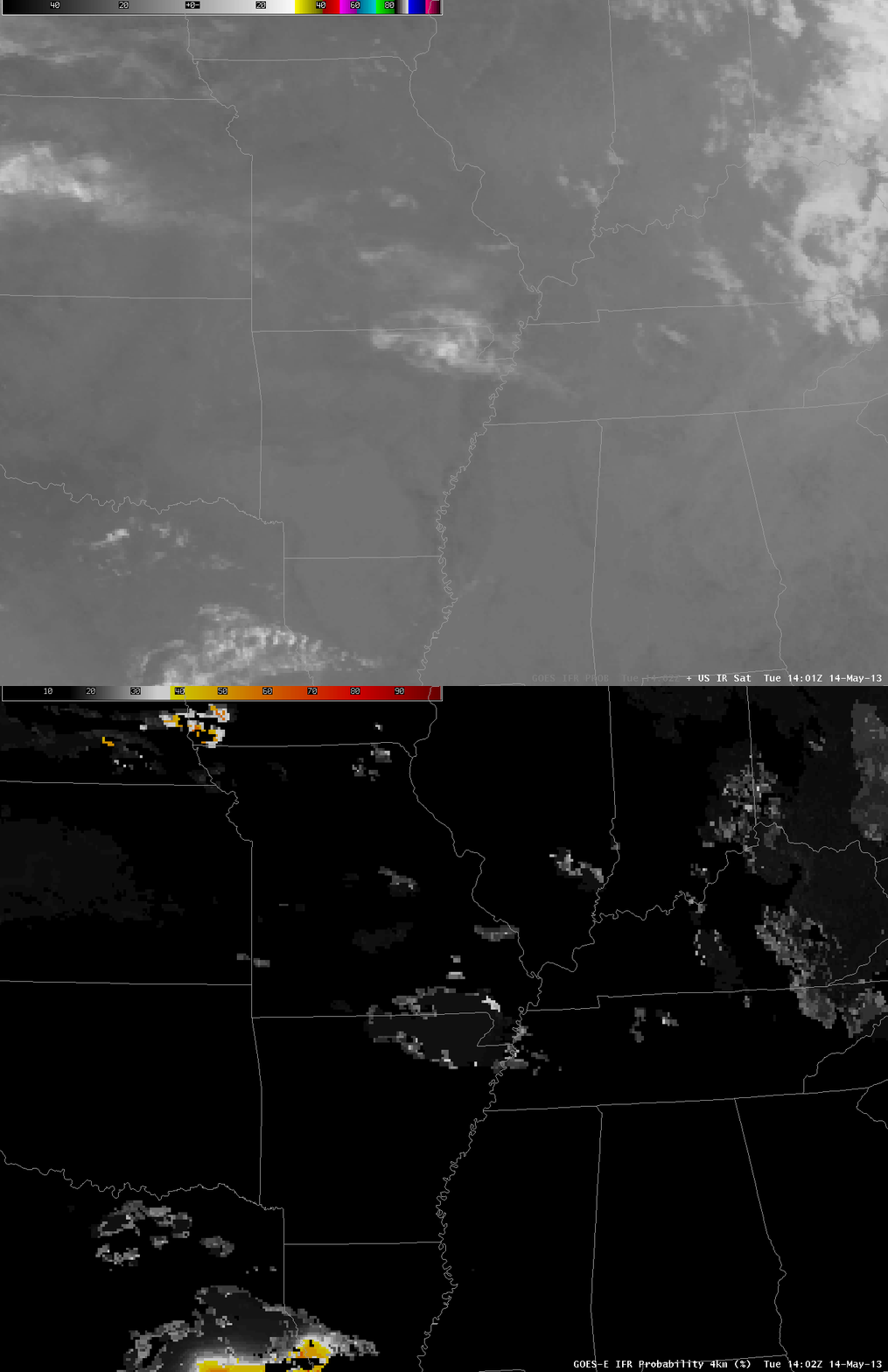
Toggle between 10.7 µm imagery and GOES-R IFR Probabilities, 1402 UTC 14 May 2013

The 10.7 µm imagery does show a cool cloud overlaying the region of modest IFR probabilities.  This cloud has the appearance of a thin cirrus cloud through which radiation emitted from the surface is filtering.  Brightness temperatures at the outer edge of the cloud — where IFR probabilities are highest — are around 10 C.  This thin cloud might normally be screened out by the daytime visible cloud mask.  However, as shown below, the thin cirrus cloud is over a surface that is white enough that the cloud mask considers it to be cloud.

Always use the IFR probability in concert with other available data to ensure the computed probabilities are sensible.

Visible Imagery, 1402 UTC on 14 May 2013

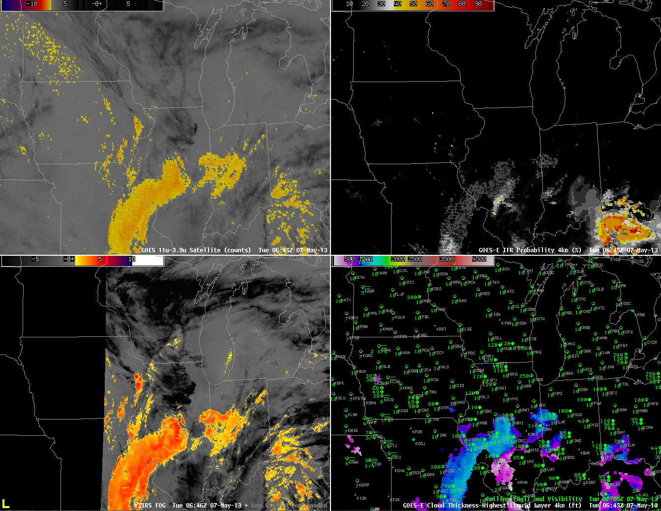
Stratus and Fog over the Midwest, Tuesday Morning May 7 2013

GOES-East Brightness Temperature Difference (10.7 µm – 3.9 µm) (Upper left), Suomi/NPP VIIRS Brightness Temperature Difference (10.35 µm – 3.74 µm) (Lower Left), GOES-R IFR Probability computed from GOES-East (Upper Right), GOES-R Cloud Thickness of highest water cloud (Lower Right), all imagery near 0645 UTC May 7 2013.

Areas of low stratus and fog developed over the upper Midwest in the morning on Tuesday, May 7th 2013.  In the image above from ~0645 UTC, both GOES and Suomi/NPP detect clouds comprised of water droplets over central Illinois southwestward through St. Louis and into central Missouri.  Careful examination of the ceilings/visibilities in that region, however, suggests that this is a mid-level stratus deck, and IFR Probabilities are suitably low.  Fog is observed in northwest Missouri and over western Iowa.  In this region, GOES does not detect water-based clouds, and IFR probabilities are low.

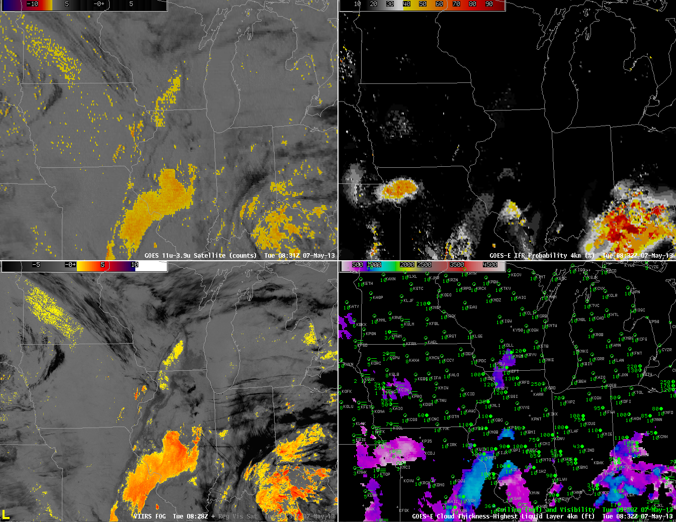
As above, but for times near 0830 UTC 7 May 2013

Two hours later, at 0830 UTC, (above) the mid-level clouds persist near St. Louis.  IFR conditions are not occurring there, however, and IFR probabilities are low.  IFR probabilities have increased around Kansas City, however, and they’re increasing in western Iowa as well, where numerous reports of reduced visibilities due to fog are occurring. This is a region where the brightness temperature difference product, the heritage method for detecting fog and low stratus, gives no information because of multiple cloud layers.

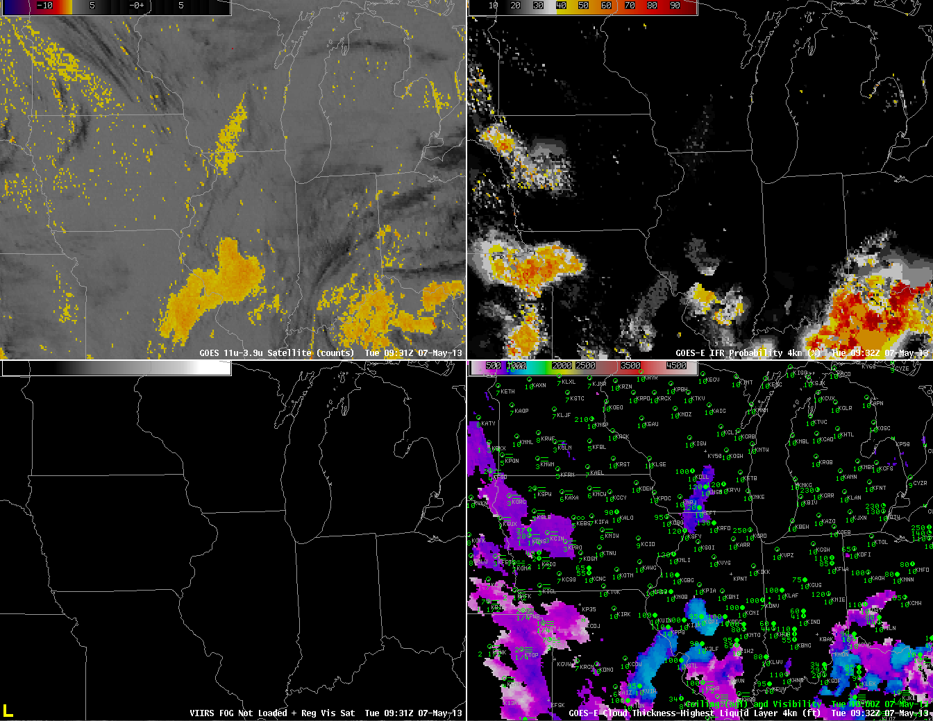
As above, but for times near 0930 UTC

At 0930 UTC (above), IFR Probabilities continue to increase over western Iowa southward into eastern Kansas, and they continue to be (correctly) suppressed near St. Louis where the traditional brightness temperature difference field notes the presence of a cloud comprised of water droplets.

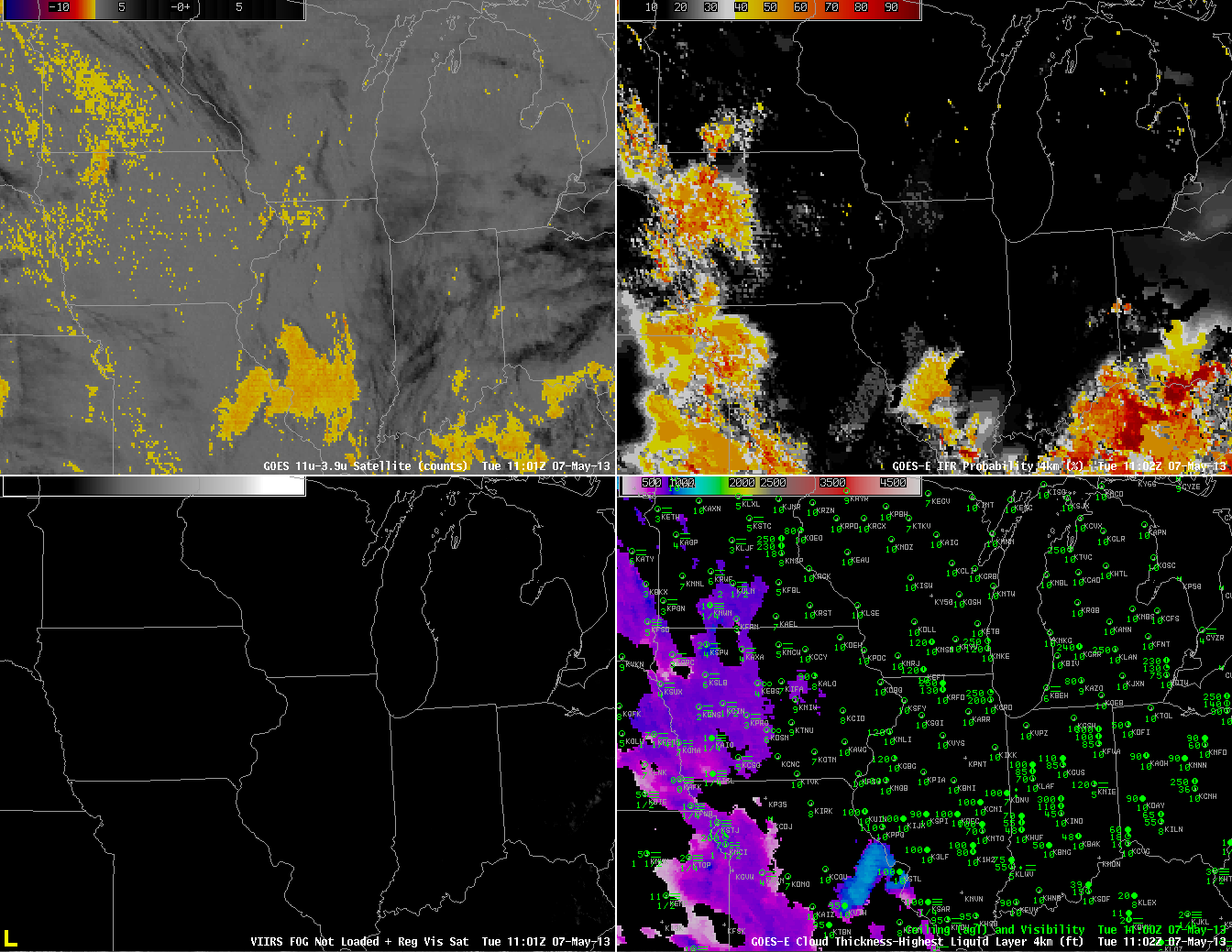
As above, but for 1100 UTC

By 1100 UTC (above), IFR probabilities are fairly high over most of western Iowa, western Missouri and eastern Kansas where many stations are reporting lowered ceilings and reduced visibility.  Again, this is a region where the traditional brightness temperature difference does not indicate the presence of fog and stratus.

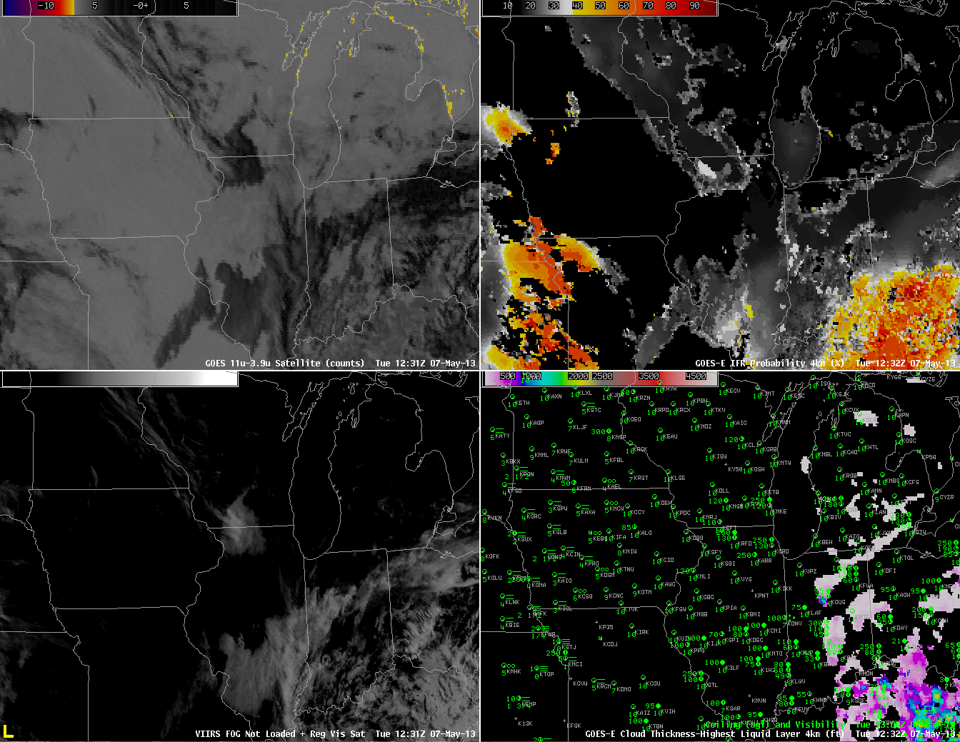
As above, but for 1230 UTC 7 May.  GOES-East Visible Imagery substituted for Suomi/NPP VIIRS Brightness Difference (bottom left)

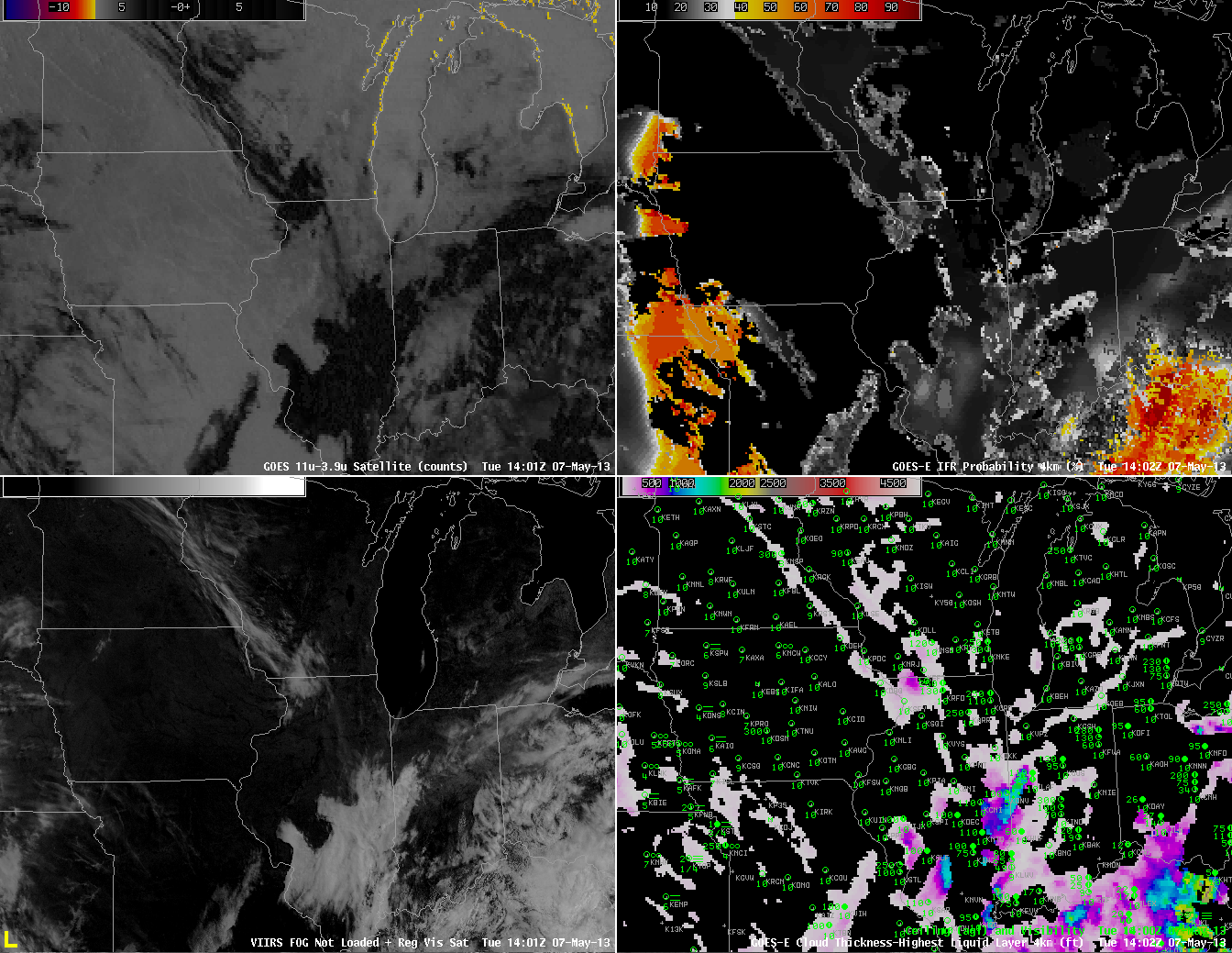
 Shortly after sunrise, at 1230 UTC, above, IFR probabilities continue to be fairly high over western Missouri and eastern Kansas, a region where some stations are reporting IFR conditions (most notably in the Missouri River valley).  One reason that IFR Probabilities have dropped quickly over Iowa is that visible imagery shows no fog there, so the cloud-clearing part of the IFR Probability algorithm used during daytime conditions is operating properly.  Note also the false brightness temperature difference signal along the western shores of the Great Lakes.  This signal arises from a co-registration error between the longwave and shortwave infrared channels.  It continues through 1400 UTC (below).

As above, but for 1402 UTC