Fog was present in the northeast Gulf of Mexico at sunset on December 9th, and the GOES-R Products was able to track its evolution as it slowly moved onshore. Late-in-the-day visible imagery from 2030 UTC 9 December (above) shows the fog bank tucked into the northeast corner of the Gulf of Mexico. By 0100 UTC on 10 December (below), some of the fog as moved inland, and visibilities/ceilings at Crystal River have decreased to IFR conditions. Note in the 0100 UTC image the presence of mid-level clouds is creating a hole in the Brightness Temperature Difference Signal over the eastern Gulf of Mexico just northwest of Tampa, and in the Cloud Thickness product. IFR Probabilities in this region are considerably reduced, as well.
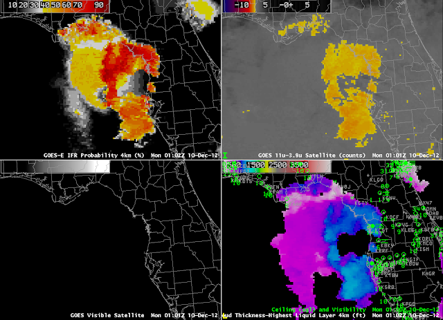 |
| As at top, but for 0100 UTC on 10 December |
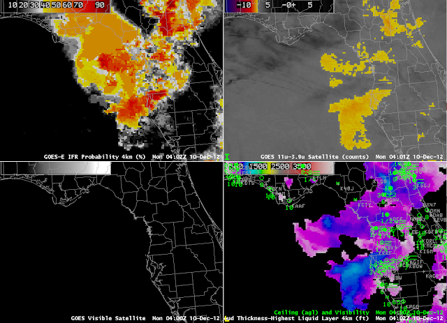 |
| As above but for 0402 UTC on 10 December |
By 0400 UTC on 10 December, the fog/low stratus continue to press inland, as ceilings and visibilities decrease. Note also the presence of higher clouds in the brightness temperature difference product. In these regions, satellite predictors are not use to compute the IFR probability product; consequently, IFR Probabilities over and around Apalachee Bay in the extreme northeast Gulf of Mexico are somewhat reduced; in addition, the field is considerably flatter (compared to the more pixelated character close to Tampa). At 0802 UTC (below), the presence of mid-level clouds peaks. Note that the brightness temperature difference product shows very little strong signal over the northern part of the Florida peninsula, despite significant visibility obscurations there (consider Gainesville, for example, with a 1/4-mile visibility).
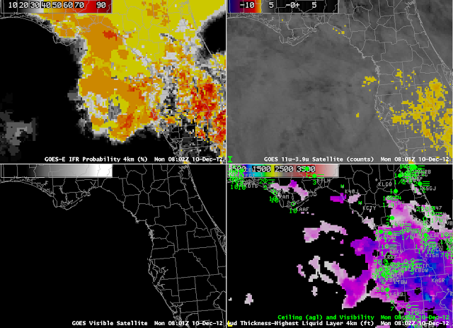 |
| As above but for 0802 UTC on 10 December |
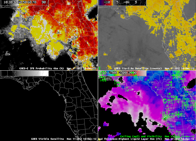 |
| As above, but for 1102 UTC on 10 December |
By 1102 UTC, the mid-level cloudiness has dissipated, allowing the brightness temperature difference to have a distinct signal. Consequently, the IFR probability field increases. The combination of both satellite predictors and model (Rapid Refresh) predictors being used allows for a consistent signal throughout the night over this evolving fog/stratus deck. In addition, the signal over the ocean, at the end of the day on 9 December, in a region where surface observations are not routine, could serve as an alert to the early development of nocturnal fog.
Note that the Tampa Bay office of the National Weather Service noted the IFR probability field in its forecast discussion:
000
FXUS62 KTBW 100034
AFDTBW

AREA FORECAST DISCUSSION
NATIONAL WEATHER SERVICE TAMPA BAY RUSKIN FL
734 PM EST SUN DEC 9 2012

.FOR THE EVENING UPDATE...
SURFACE HIGH PRESSURE WILL REMAIN OVER THE REGION WITH A STRONG
MID LEVEL SUBSIDENCE INVERSION AND STABLE AIR MASS OVER THE
FORECAST AREA. AREA OF FOG...LOCALLY DENSE...HAS PERSISTED THROUGH
THE DAY OVER THE COASTAL WATERS NORTH OF VENICE AND LOCALLY
ONSHORE FROM ABOUT ANNA MARIA ISLAND NORTH TO CEDAR KEY. AREA OF
LOCALLY DENSE FOG WILL GRADUALLY PUSH ONSHORE THE COASTAL
COUNTIES THIS EVENING...WITH FOG DEVELOPING OVER INTERIOR BECOMING
LOCALLY DENSE AFTER MIDNIGHT. CURRENT ZONES ARE ON TRACK WITH NO
UPDATE PLANNED.

&&

.AVIATION...
GOES-R IFR AND LIFR PROBABILITY PRODUCTS NICELY OUTLINE AN AREA OF
SEA FOG THAT HAS LINGERED ACROSS NEAR SHORE WATERS FROM BIG BEND
SOUTH TO AROUND VENICE. THIS SEA FOG IS RIGHT ALONG THE COASTLINE
AND IS VISIBLE ON SOME BEACH WEB CAMS IN THE AREA AND THEREFORE IS
POISED TO MOVE INLAND ONCE TEMPS FALL SOME. THE BIG QUESTION IN ALL
THIS IS WHETHER THE WEAK WRLY WINDS ASSOC W/ THE SEA BREEZE
CIRCULATION WILL CONTINUE LATE ENOUGH TO PUSH THE SEA FOG BANK
INLAND IMPACTING TAMPA BAY AREA SITES. PREVIOUS TAFS WERE COUNTING
ON THIS OCCURRING AND WILL CONTINUE CLOSE TO THE FORECAST ALTHOUGH
HAVE NOTED 18Z MAV AND LATEST LAMP HAVE STRONGLY BACKED OFF ON THE
FOG FOG FORECAST AND NOW CONFINED FOG TO MUCH LATER IN THE NIGHT
CLOSER TO SUNRISE. WILL HAVE TO WATCH CLOSE AND AMEND AS NEEDED IN
NEXT FEW HOURS AS ONSET OF LIFR CONDITIONS IS BIGGEST QUESTION MARK
TONIGHT. LIFR CONDITIONS ARE PRETTY CERTAIN AROUND 12Z AND WILL SEE
SLOW IMPROVEMENT TO MVFR LEVELS THROUGH 18Z. MVFR LEVELS MAY LINGER
AND CONTINUE BEYOND 18Z AS MOISTURE SURGES INTO THE AREA LEADING TO
SCT SHRA ACROSS THE ENTIRE AREA AND POSSIBLY A FEW TSTMS MAINLY
AROUND OR EAST OF SRN SITES (FMY, RSW, PGD). MODELS SUGGEST
POTENTIAL DEVELOPMENT OF MORE WIDESPREAD SEAFOG EVENT LATE TOMORROW
AS MOISTURE CONTINUES TO INCREASE AND A MORE PERSISTENT SW FLOW
DEVELOPS.
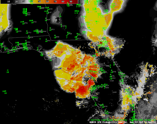 |
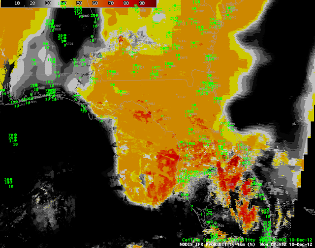
| MODIS-based GOES-R IFR Probabilities, 0334 UTC 10 December (above) and 0745 UTC 10 December (below) |
MODIS-based GOES-R IFR Probabilities, above, show a similar evolution of the field, from fairly constrained over northern Florida at 0334 UTC, and determined by both satellite and model fields, to more widespread but deteremined more by model fields only at 0745 UTC.


