Category Archives: Mid-Atlantic

IFR Conditions in Pennsylvania and Oregon

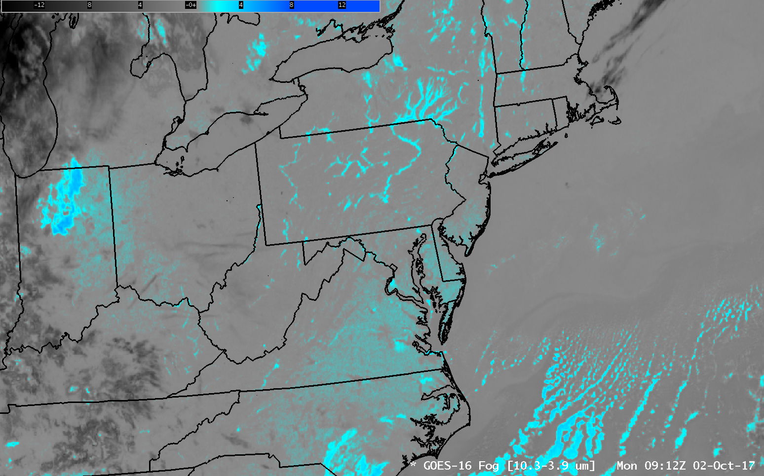
GOES-16 Brightness Temperature Difference (10.3 µm – 3.9 µm) at 0912 UTC on 2 October 2017 over the Mid-Atlantic States (click to enlarge)

GOES-16 data posted on this page are preliminary, non-operational and are undergoing testing.

The images above show the GOES-16 Brightness Temperature Difference at the same time at two places over the United States: The mid-Atlantic States (above) and Oregon and surrounding States (below).  The ‘Fog’ Product, as this Brightness Temperature Difference is commonly called, in reality identifies only clouds that are made up of water droplets — that is, stratus.  A cloud made up of water droplets emits 10.3 µm radiation nearly as a blackbody does. Thus, the computation of Brightness Temperature — which computation assumes a blackbody emission — results is a temperature close to that which might be observed.  In contrast, those water droplets do not emit 3.9 µm radiation as a blackbody would.  Thus, the amount of radiation detected by the satellite is smaller than would be detected if blackbody emissions were occurring, and the computation of blackbody temperature therefore yields a colder temperature, and the brightness temperature difference field, above, will show clouds made up of water droplets as positive, or cyan in the enhancement above.

The River Valleys of the northeast show a very strong signal that suggests Radiation Fog is developing over the relatively warm waters in the Valleys.  The Delaware, Hudson, Mohawk, Connecticut, Susquehanna, Allegheny, Monongahela, and others — all show a signature that one would associate with fog.  A signal is also apparent from southern New Jersey southwestward through the Piedmont of North Carolina.  Would you expect there to be fog there as well, given the signal?

The State of Oregon at the same time shows a very strong signal in the ‘Fog’ Product.  A clue that this might be only stratus, and not visibility-restricting fog, lies in the structure of the clouds — they do not seem to be constrained by topographic features as is common with fog.
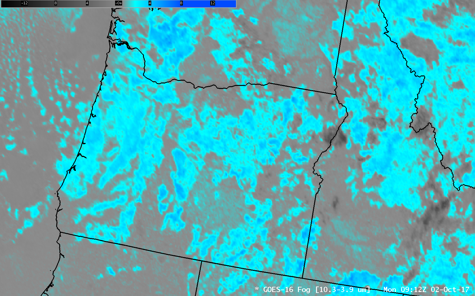
GOES-16 Brightness Temperature Difference (10.3 µm – 3.9 µm) at 0912 UTC on 2 October 2017 over Oregon and adjacent States (click to enlarge)

GOES-R IFR Probabilities are computed using Legacy GOES (GOES-13 and GOES-15) and Rapid Refresh model information; Preliminary IFR Probability fields computed with GOES-16 data are available here.  These GOES-16 fields should be available via LDM Request when GOES-16 becomes operational as GOES-East.

GOES-R IFR Probability Fields use both the Brightness Temperature Difference field (10.7 µm – 3.9 µm) from heritage GOES instruments and information about low-level saturation from Rapid Refresh Model output.  The horizontal resolution on GOES-13 and GOES-15 is coarser than on GOES-16 (4 kilometers at the sub-satellite point vs. 2 kilometers), so small river valleys will not be resolved.  (It is also difficult for the Rapid Refresh model to resolve small valleys).
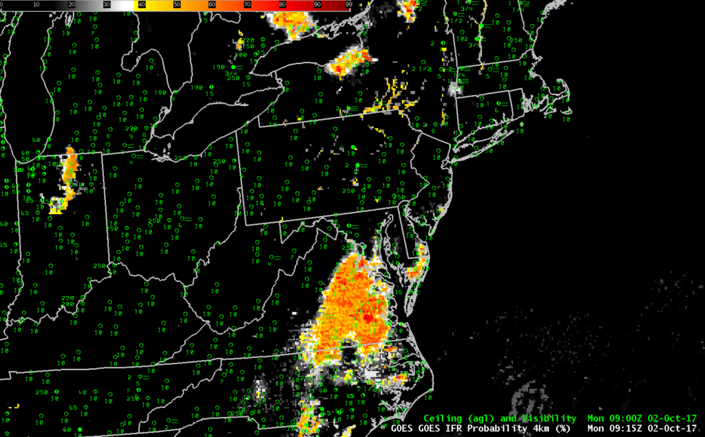
GOES-R IFR Probability fields at 0915 UTC, along with 0900 UTC surface observations of ceilings and visibility (Click to enlarge)

The IFR Probability Fields, above, show some signal over the river valleys of the northeast; that signal is mostly satellite-based, but the poor resolution of GOES-13 means that fog/stratus in the river valleys is not well-resolved. Still, a seasoned forecaster could likely interpret the small signals that are developing to mean fog is in the Valleys.  (And restrictions to ceilings and visibilities are certainly reported in the river valleys of the Mid-Atlantic and Northeast)   IFR Probabilities are also noticeable over southeast Virginia, although widespread surface observations showing IFR Conditions are not present.  (Such observations are somewhat more common near sunrise, at 1130 UTC).

IFR Probabilities are much less widespread over Oregon, with most of the signal over western Oregon related to the topography.  In this example, IFR Probabilities are ably screening out regions where elevated stratus is creating a strong signal for the satellite in the Brightness Temperature Difference field.

Why Fused Data is better than Satellite Data alone in detecting IFR Conditions: Pennsylvania Example

GOES-R IFR Probability Fields, 0200-1100 UTC on 11 July 2017 (Click to enlarge)

GOES-16 data posted on this page are (still!) preliminary, non-operational data and are undergoing testing

GOES-R IFR Probabilities are computed using Legacy GOES (GOES-13 and GOES-15) and Rapid Refresh model information; GOES-16 data will be incorporated into the IFR Probability algorithm in late 2017

Low ceilings and reduced visibilities developed in and around thunderstorms from Ohio and Michigan into southwestern Ontario, upstate New York and northern Pennsylvania during the morning of 11 July 2017. (Reduced visibilities/lowered ceilings persisted past 15 UTC as shown in this image from here). Regions of IFR conditions over northwestern Pennsylvania are in regions of higher IFR Probability after 0500 UTC (over northwest Pennsylvania) and after 0700 UTC (over much of northern Pennsylvania) that have the characteristic flat field look that comes from having only Rapid Refresh Model output drive the Probability (because high clouds, as might occur downwind of Convection, prevent the satellite from seeing low clouds). GOES-R IFR Probability fields also retain a signal through sunrise, as shown in the this toggle between 1000 UTC and 1100 UTC, two times on either side of the terminator.

Because high clouds inhibit the view of low stratus (and potential fog), products that rely on solely satellite data become ineffectual as a situational awareness tool. Consider the toggle below from 0800 UTC of GOES-R IFR Probabilities, the GOES-16 “Fog Product” Brightness Temperature Difference (10.3 µm – 3.9 µm) and the Advanced Nightime Microphysics RGB (that uses the Brightness Temperature Difference Product as one of its components). IFR Conditions over NW Pennsylvania are not diagnosed by the GOES-16 products that rely on the 10.3 µm – 3.9 µm Brightness Temperature Difference field. Where there is a clear field of view, all three products can highlight IFR conditions (in/around London Ontario, for example). Regions of low stratus — but not fog — are also highlighted over parts of upstate New York by the GOES-16 products. (Similar toggles at 0915 and 1100 UTC are available; note that the signal from GOES-16 becomes weak at 1102 UTC because increasing amounts of solar reflectance change the sign of the 10.3 µm – 3.9 µm Brightness Temperature Difference.

These examples typify why GOES-R IFR Probability fields typically have better statistics as far as IFR detection is concerned: Model data fills in regions where high clouds are present, and model data screens out regions where stratus is highlighted by a Brightness Temperature Difference field, but where fog does not exist.

GOES-R IFR Probabilities (computed using GOES-13 and Rapid Refresh Data), GOES-16 “Fog Product” Brightness Temperature Difference (10.3 µm – 3.9 µm) and the Advanced Nighttime Microphysics RGB, all around 0800 UTC on 11 July 2017 (Click to enlarge)


Dense Fog from the Ohio Valley to North Carolina

Note: GOES-R IFR Probabilities are computed using Legacy GOES (GOES-13 and GOES-15) and Rapid Refresh model information; GOES-16 data will be incorporated into the IFR Probability algorithm in late 2017.

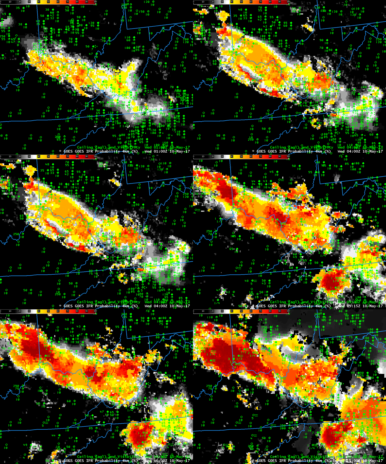
The weather.gov website on Wednesday morning 10 May 2017 showed two dense fog advisories, one near Cincinnati, OH and one near Greensboro, NC. The aviation weather website showed an IFR Sigmet in between the two regions of dense fog. The fog formed along a stationary front that sat over the region.

How well did GOES-R IFR Probabilities and GOES-13 Brightness Temperature Difference fields capture this event? The animation of GOES-R IFR Probability, below, computed using data from GOES-13 and the Rapid Refresh Model, shows enhanced probabilities early in the evening that increased with time. The orientation of the field — from west-northwest to east-southeast — aligns well with the regions of developing fog.

GOES-R IFR Probability fields, 0100, 0400 and 0700 – 1100 UTC on 10 May 2017 (Click to enlarge)

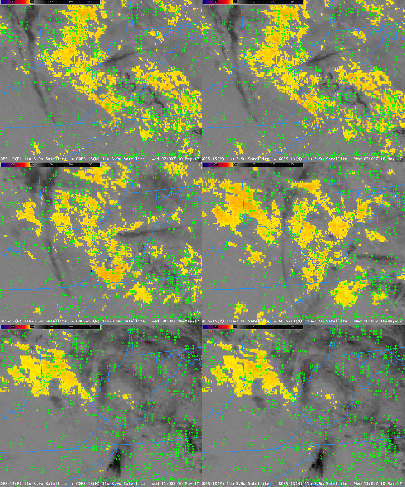
The brightness temperature difference field, below, did not perform as well in outlining the region of low ceilings/reduced visibilities because of the presence of high clouds that interfered with the ability to detect low clouds. Consequently, the highest brightness temperature differences (3.9 µm – 10.7 µm) do not align so well with the regions of developing fog. Note also that at the end of the animation — 1100 UTC — increasing amounts of reflected solar 3.9 µm radiation is changing the character of the field from negative to positive. In contrast, the IFR Probability fields (above) maintain a consistent signal through sunrise.

GOES-13 Brightness Temperature Difference fields (3.9 µm – 10.7 µm), 0700-1100 UTC on 10 May 2017 (Click to enlarge)

Fog after convection in Virginia and North Carolina

ifrp_28sept2016_0215_1125anim

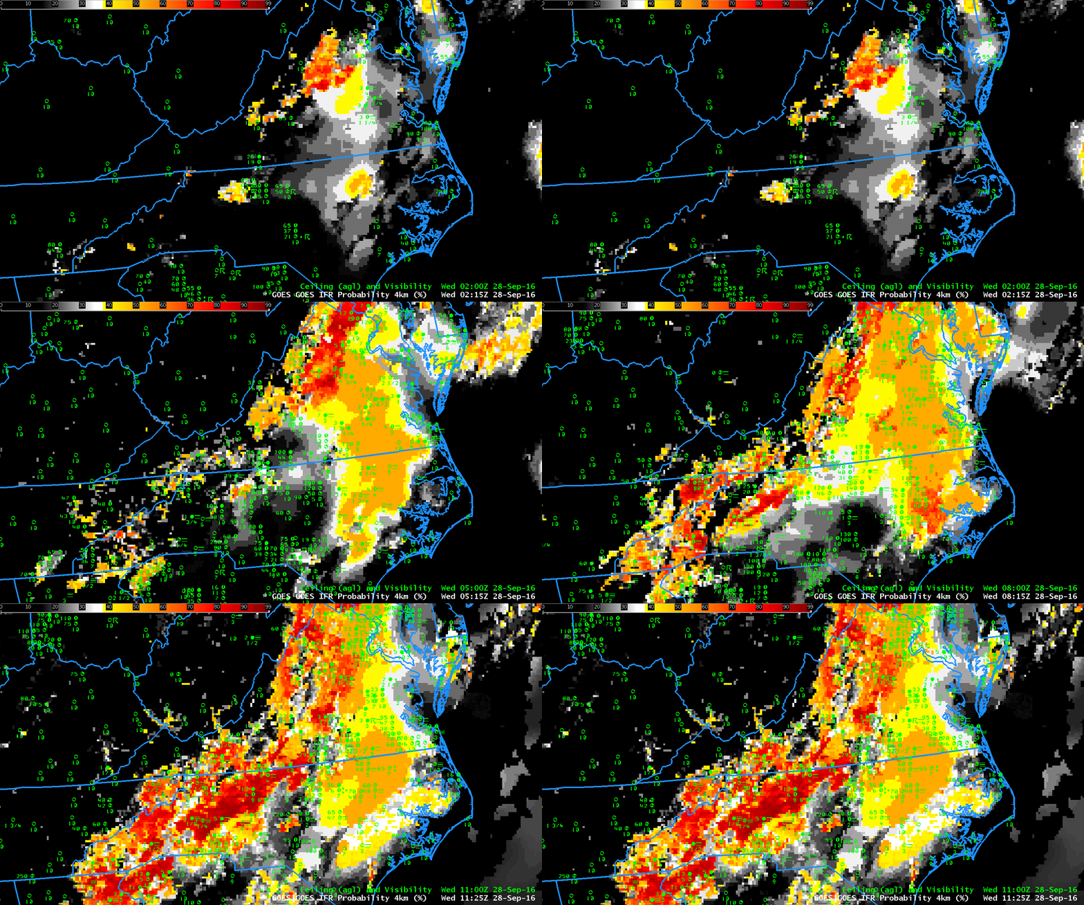
GOES-R IFR Probability fields, hourly from 0215 UTC through 1115 UTC on 28 September 2016 (Click to enlarge)

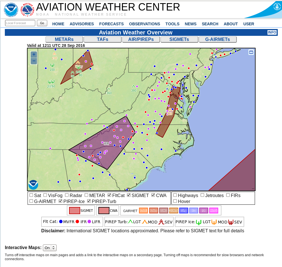
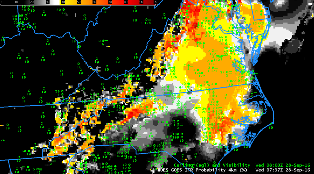
IFR and Low IFR Conditions developed over parts of Virginia and the Carolinas Piedmont Region during the morning of 28 September 2016. The screengrab below, from the Aviation Weather Center, shows the areal extent of the reduced visibilities and/or low ceilings.  (The text of the IFR Sigmet is here.)  Fog over southeastern  Virginia is developing under multiple cloud decks associated with the convection near a front.  IFR Probabiities in this region are determined by Rapid Refresh data that shows low-level saturation; the flat-looking field over that region is characteristic of model-only IFR Probability fields.  Farther to the southwest, over western North Carolina, IFR Probabilities are determined by both satellite and model data;  notice how pixelated the data are in that region.

awc_1213utc_28sept

Screengrab from the Aviation Weather Center at 1215 UTC on 28 September 2016 (Click to enlarge)

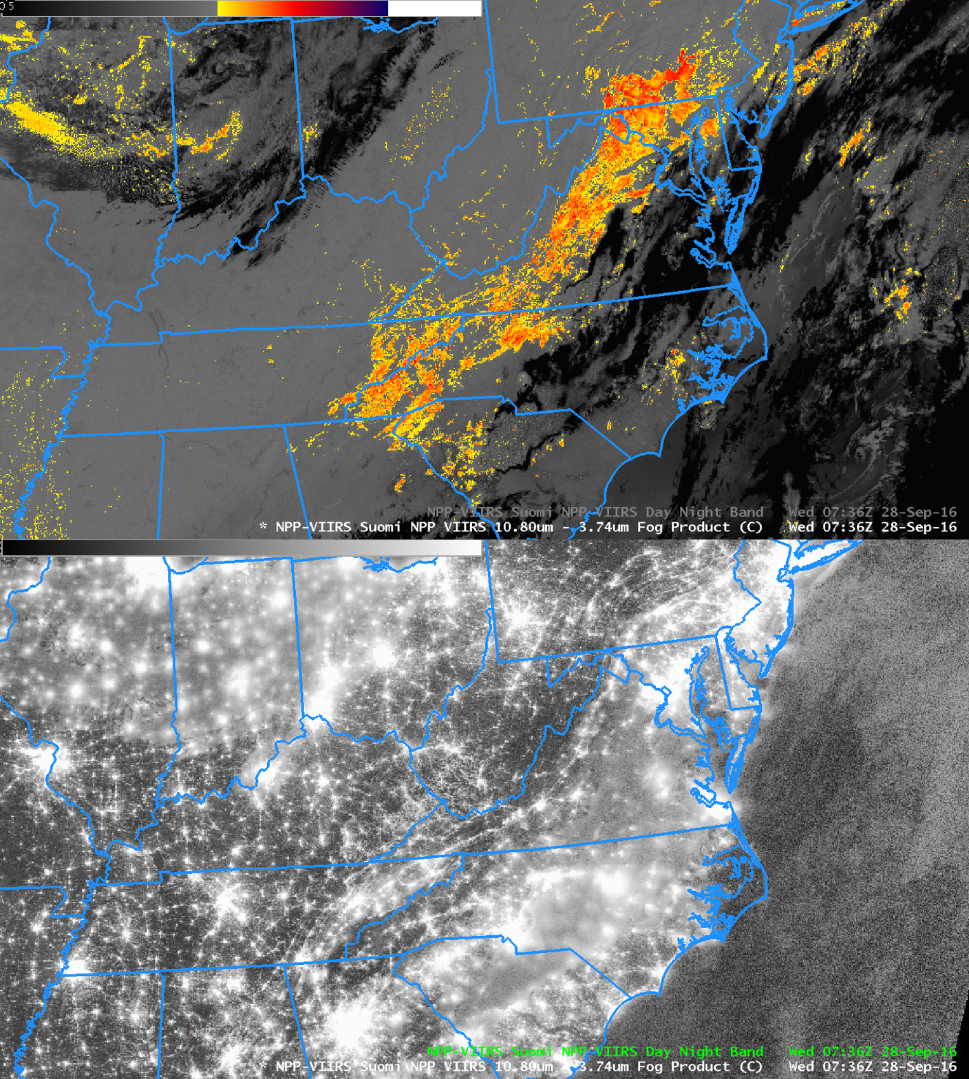
Suomi NPP overflew the eastern United States shortly after 0730 UTC, and the toggle below shows the Day Night Visible Band and the Brightness Temperature Difference field (11.45 – 3.74 ).   Water-based clouds (yellow and orange in the enhancement used) are detected just to the west of cirrus and mixed-phase clouds (black in the enhancement used).  The 0737 UTC IFR Probability field, at bottom, had model-data only as predictors in regions where Suomi NPP shows multiple cloud layers.  Note also that the 1-km resolution of Suomi NPP is resolving the developing valley fogs in the Appalachian mountains of Ohio, West Virginia and Kentucky.  There are only a few pixels in the IFR Probability field that are suggesting valley fog development — but note in the end of the animation at the top of this post that more valley pixels show IFR Probability signals.  When GOES-R is flying, its superior (to GOES-13) 2-km resolution should mitigate this too-slow identification of valley fogs.

snpp_btd_dnb_0736_28sep2016toggle

Suomi NPP Day Night Band Visible (0.70) and Brightness Temperature Difference (11.45 – 3.74) fields at 0736 UTC on 28 September 2016 (Click to enlarge)

ifrp_28sept2016-35

GOES-R IFR Probability fields at 0737 UTC, and surface observations of ceilings and visibilities at 0800 UTC (Click to enlarge)

Coastal Stratus/Fog along the East Coast

GOES_IFRP_0215_1400anim_17March2016

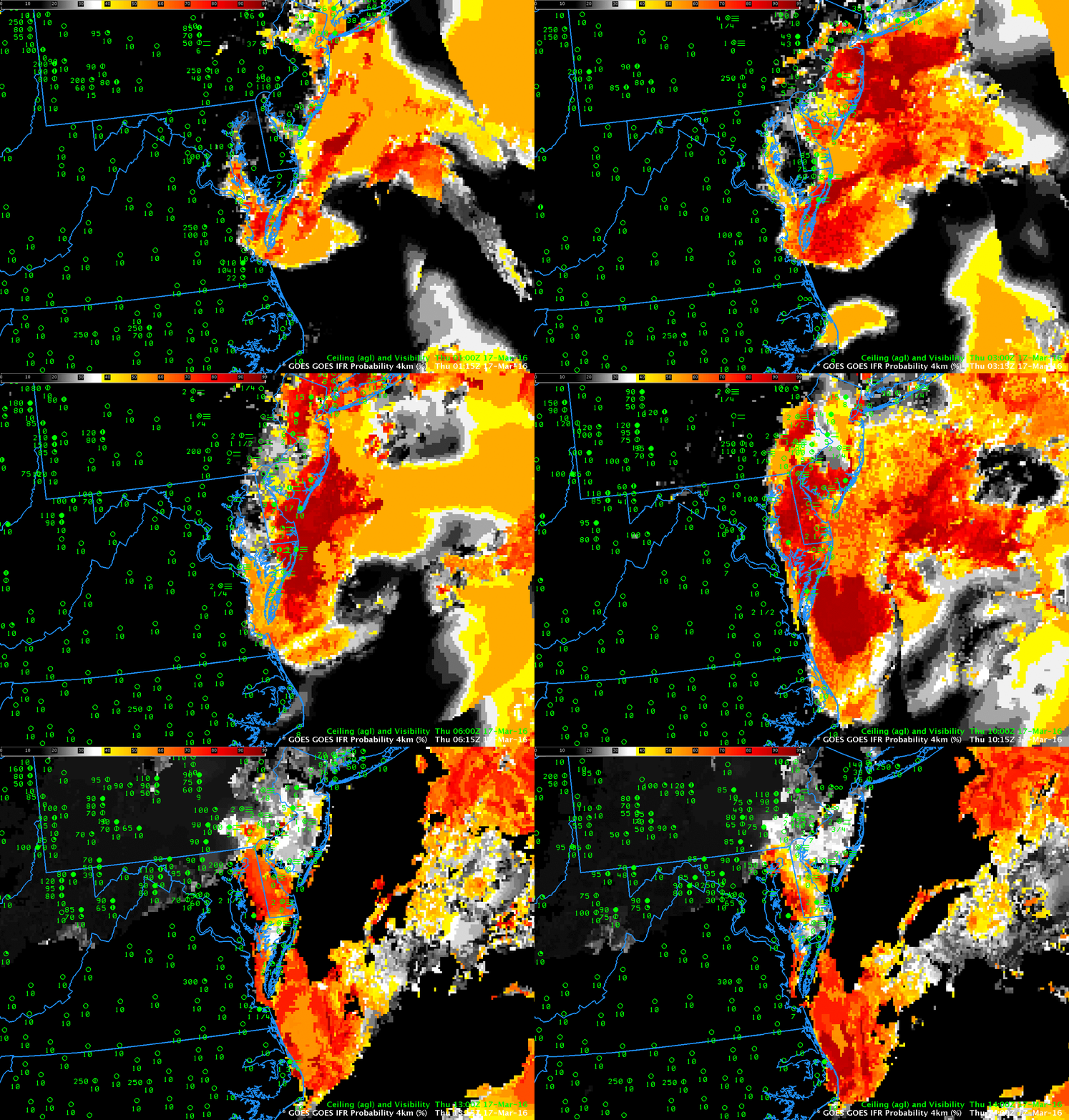
GOES-R IFR Probabilities, Hourly from 0215-1415 UTC 17 March 2016 (Click to enlarge)

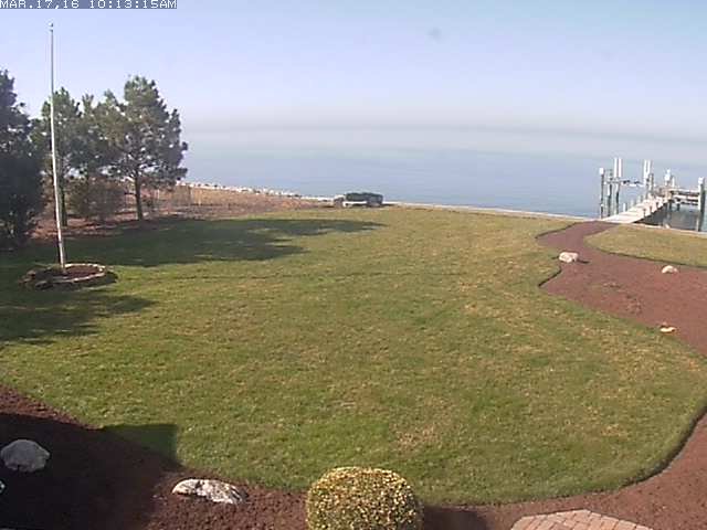
GOES-R IFR Probabilities captured the development of coastal fog over coast of the Atlantic Ocean from Long Island south to North Carolina on the morning of March 17 2016 behind a weak cold front. IFR Conditions penetrated into the Delaware and Lehigh River Valleys over Pennsylvania. In general, GOES-R IFR Probability fields captured the region of IFR conditions as it developed and expanded. Note that the IFR Probabilities remained elevated through 1400 UTC along the eastern shore of Chesapeake Bay. The 1413 UTC webcam image from Tilghman Island, below, (source), shows an offshore fogbank.

TilghmanMDViewOverBay

IFR Conditions with a Coastal Storm

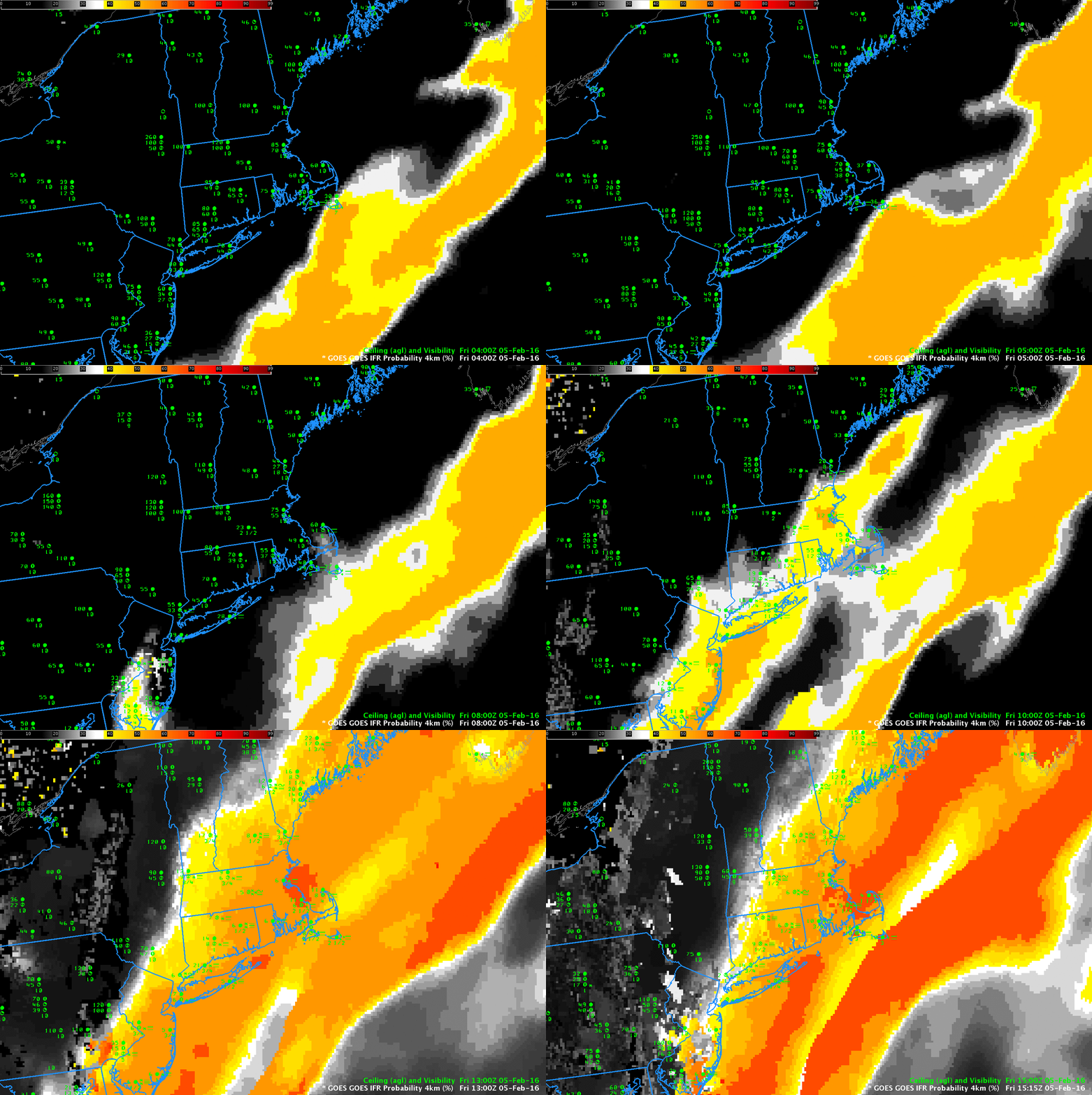
GOES_IFRPanim_0400_1515_05Feb2016

GOES-R IFR Probabilities, hourly from 0400 through 1515 UTC, 5 February 2016 (Click to enlarge)

IFR Conditions frequently occur with storms along the East Coast. Satellite detection of such conditions is very difficult because of the multiple cloud layers that accompany cyclogenesis. The IFR Probabilities, above, have a character that reflects their determination solely from Rapid Refresh Data. That is, Satellite Predictors were not considered over much of New England because of the presence of multiple cloud layers, as suggested in the Water Vapor animation below.

IFR Probability fields are initially entirely offshore in the animation above, and IFR conditions are not observed over southern New England.  Note how IFR probabilities initially increase over land over southern New Jersey and then quickly move northeastward into southern New England as IFR Conditions develop.  Because satellite predictors are unavailable in these regions (on account of the many clouds layers), the simultaneous development of high IFR Probabilities with observed IFR Conditions argues for a good simulation of the observed weather by the Rapid Refresh.  Fused data products such as IFR Probability fields join the strengths of different systems to provide a statistically more robust field than is possible from the individual pieces.

When daytime arrives — at around 1215 UTC in the animation above — a distinct transition is apparent in the GOES-R IFR Probability fields.  This occurs because Satellite Data — visible satellite data — can be used during daytime to articulate the regions of cloudiness with more precision.  Because cloudiness in general is better defined, IFR Probability fields (that require the presence of clouds) increase somewhat, and the color table used emphasizes that change.

WV__0400_1300_05Feb2016anim

GOES-13 Water Vapor 3-hourly Animation, 0400-1300 UTC, 5 February 2016 (Click to enlarge)

Fog in the Carolinas

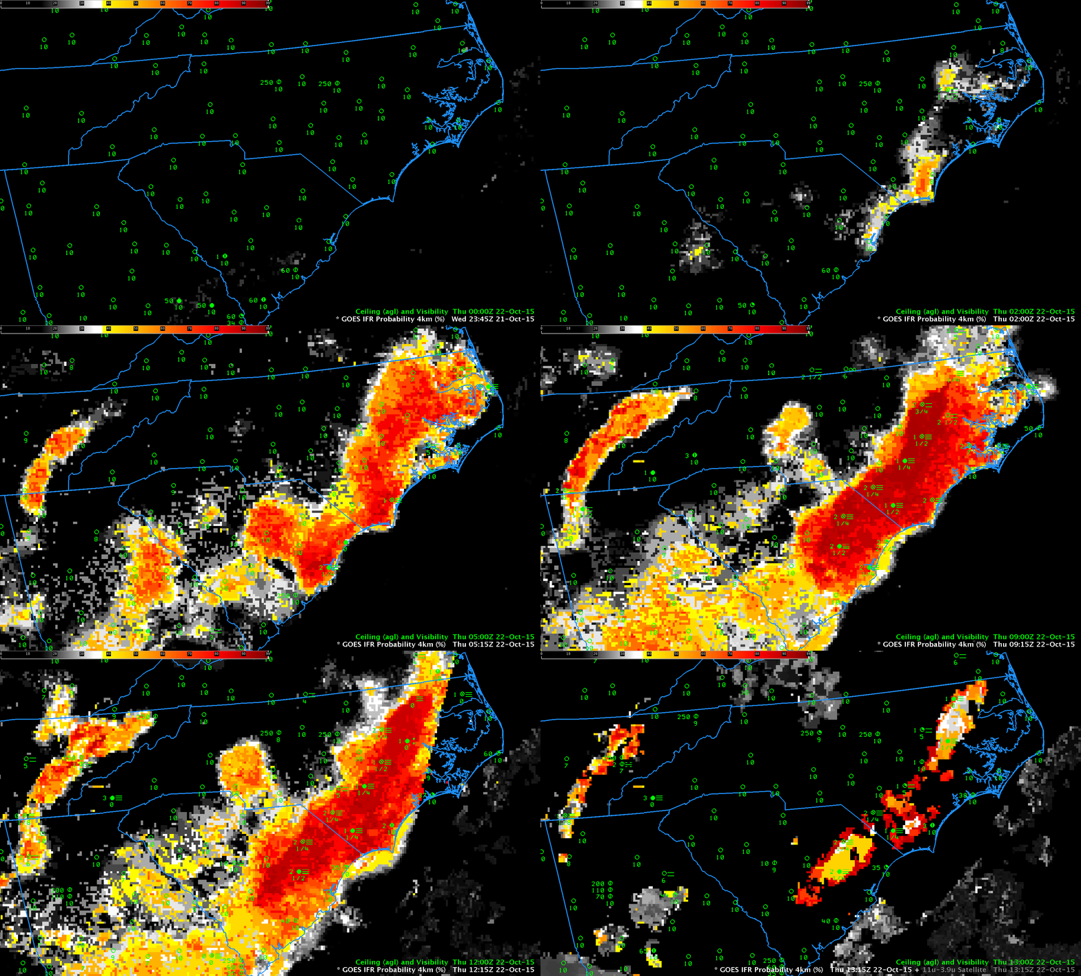
GOES_IFR_0000_1315_22Oct2015anim

GOES-R IFR Probabilities, hourly from 0000 UTC through 1315 UTC on 22 October 2015 (Click to enlarge)

Dense fog developed over South and North Carolina on the morning of 22 October 2015, just inland from the coast (Click here for screenshot from the National Weather Service homepage from Wilmington NC).  The animation, above, shows the hourly evolution of the GOES-R IFR Probability fields from just after sunset on the 21st through sunrise on the 22nd. Highest probabilities of IFR Conditions overlap the stations where IFR Conditions occur. GOES-R Cloud Thickness also gives information on where the thickest clouds are; the 1115 UTC Cloud Thickness (the final field before twilight conditions change the 3.9 µm emissivity used to diagnose Cloud Thickness) shows the thickest clouds removed from the coast; compare that region to the regions with fog remaining at 1315 UTC in the animation above. There is good overlap. The maximum cloud thickness in the just-before-sunrise image below is a bit over 1000 feet, in northeastern North Carolina; according to this scatterplot that relates pre-sunrise cloud thickness to dissipation time, fog dissipation should occur within 3 hours, that is by 1415 UTC.

GOES_CLDTHK_1115_22Oct2015

GOES-R Cloud Thickness, 1115 UTC on 22 October (Click to enlarge)

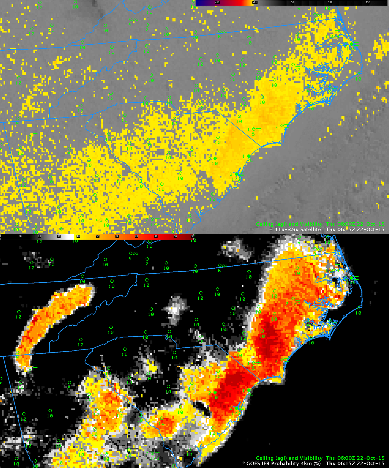
IFR Probabilities have better statistics in outlining regions of dense fog. This is because fog that reduces visibility and low stratus that does not reduce visibility can look very similar to a satellite. IFR Probability fields incorporate near-surface information in the guise of Rapid Refresh model predictions of low-level saturation that better refine regions where low stratus extends down to the ground. There are regions where brightness temperature difference has a fog-like signal with high ceilings/good visibility (central South Carolina, for example). These regions have low IFR Probability values because the Rapid Refresh model does not predict low-level saturation. Fusing satellite and model data yields a better product.

GOES_BTD_IFR_0615_22Oct2015toggle

GOES-13 Brightness Temperature Difference (10.7µm – 3.9µm) and IFR Probability fields, 0615 UTC on 22 October 2015 (Click to enlarge)

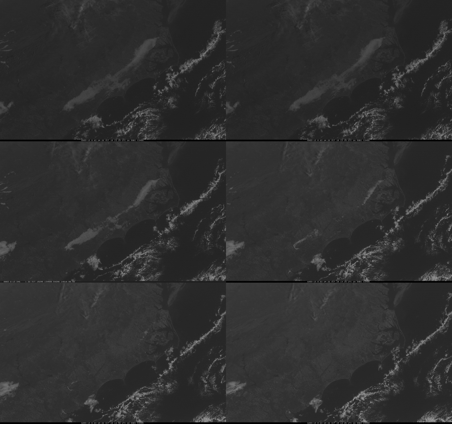
The visible animation, below, shows that fog dissipated completely shortly after 1430 UTC, in accordance with expectations based on the Cloud Thickness.

GOES13_VIS_22OCT_1315_1445anim

GOES-13 Visible Imagery, 1315 through 1445 UTC on 22 October (Click to enlarge)

IFR Probabilities when thick clouds are present

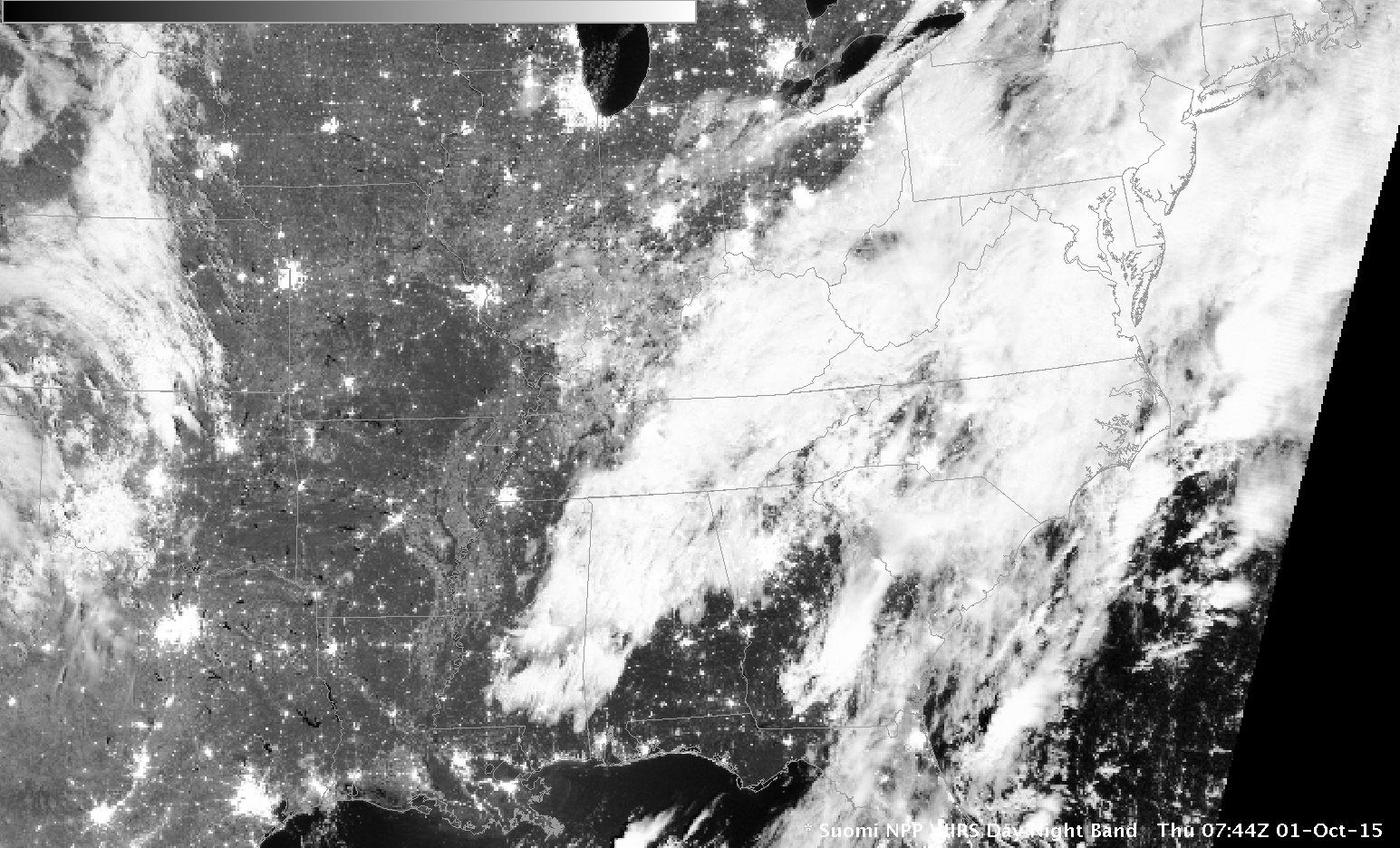
SNPP_DNB_0744UTC_01Oct2015

Suomi NPP Day Night Visible (0.70 µm) Image, 0744 UTC on 1 October 2015 (Click to enlarge)

When thick clouds are present, as along the East Coast of the United States early on 1 October 2015, as depicted by the Suomi NPP Day Night band (0.70 µm) image above, satellite detection of low clouds is problematic. This is why GOES-R IFR Probability fields incorporate information from model data so that useful guidance can be produced on whether IFR Conditions exist.

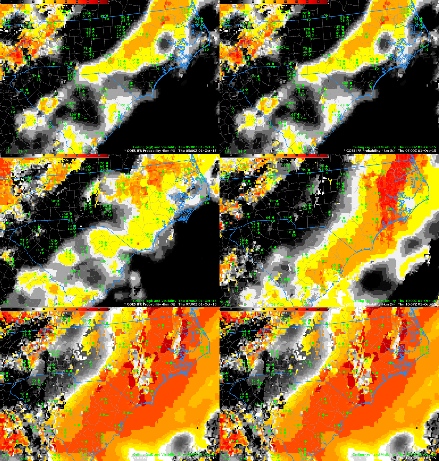
IFR Probabilities increase slowly over coastal South and North Carolina after midnight on 1 October — and the fields do a good job of outlining where IFR Conditions are occurring. In most locations, at most times, the fields are not pixelated. The smooth nature arises when model fields (which are relatively smooth) are used (and satellite data that are more pixelated are not used) to generate the IFR Probability Fields. Some holes in the extensive cloud cover occur over North Carolina during the animation: the IFR Probability field takes on a more pixelated appearance when that happens — and the Probability value increases when satellite data can also be used as a Predictor.

IFRProb_01October2015anim_05-12

GOES-R IFR Probability fields created with GOES-13 Imager and Rapid Refresh model Data, 0500-1215 UTC on 1 October 2015 (Click to enlarge)

The GOES-R IFR Probability field at 1145 UTC includes a north-south oriented artifact. To the east of the obvious line, day-time predictors are used in the GOES-R IFR Probability computation; to the west, night-time predictors are used. One of the daytime predictors is Visible Imagery that is used to cloud-clear more accurately. The IFR Probability where daytime predictors are used is larger because there is more confidence that a cloud does exist.

Fog along the East Coast

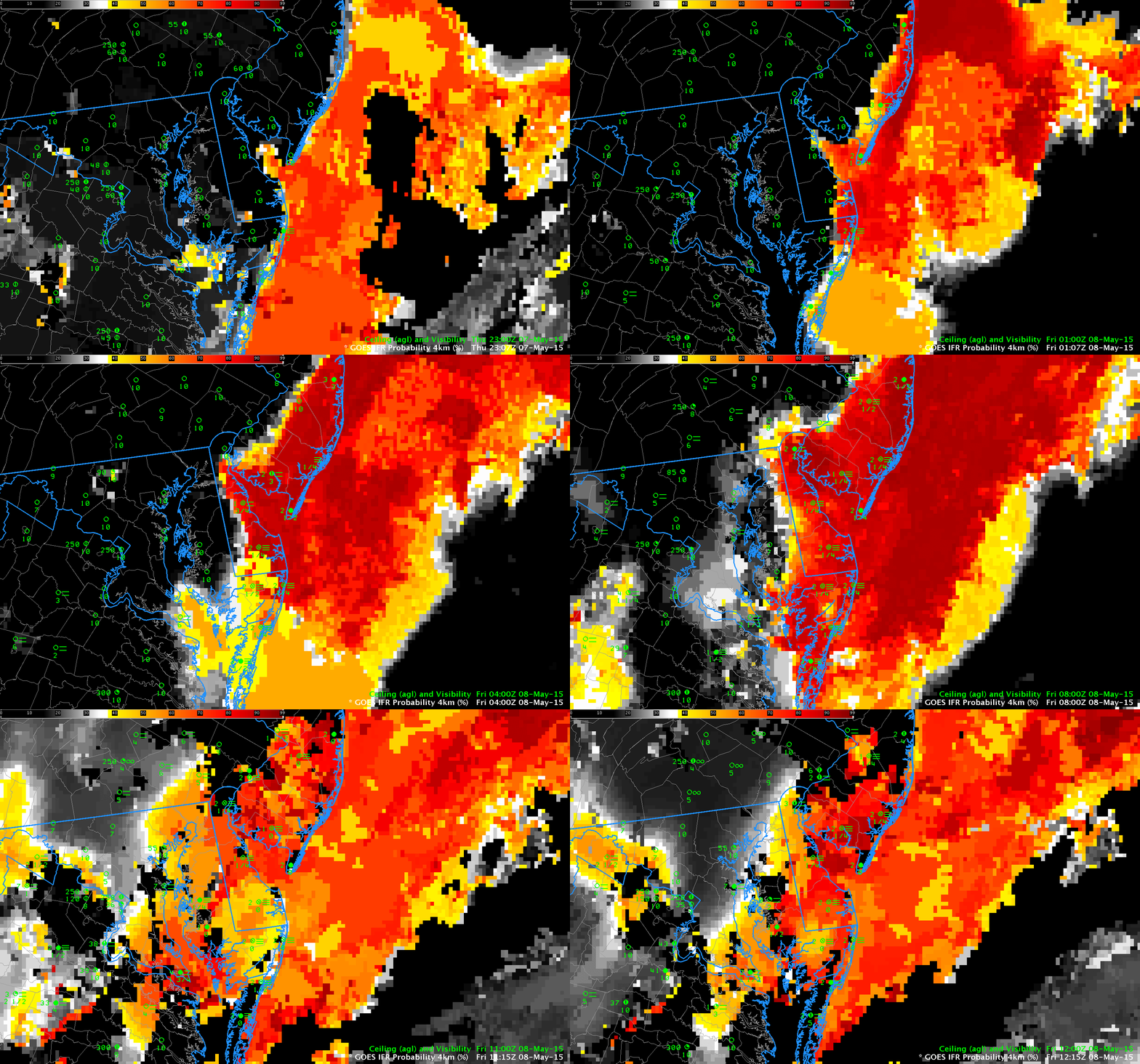
GOESIFR_8May2015anim

GOES-R IFR Probability Fields computed from GOES-East and Rapid Refresh Data, hourly from 2300 7 May through 1200 8 May, and surface observations of ceilings/visibility (Click to enlarge)

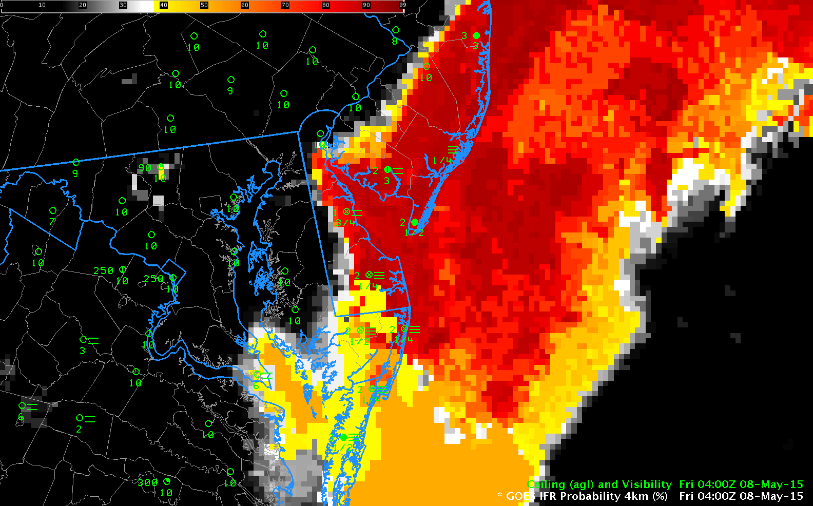
GOES-R IFR Probability Fields showed large values at sunset over the Atlantic Ocean east of New Jersey and the Delmarva Peninsula. As night progressed, that fog penetrated inland. The IFR Probability field accurately depicts the region where visibilities due to fog were reduced. The 0400 UTC image in the animation above (reproduced below), has qualities that highlight the benefit of a fused product. The Ocean to the east of the southern Delmarva peninsula is overlain with multiple cloud layers that make satellite detection of low clouds/fog problematic. In this region, satellite data cannot be used as a predictor and the GOES-R IFR Probability field is a flat field. Because the GOES-R IFR Probability product includes information from the Rapid Refresh model (2-3 hour model forecasts, typically) and because saturation is indicated in the lowest 1000 feet of the model, IFR Probabilities over the ocean are high in a region where satellite data cannot be used as a predictor.

GOESIFR_8May2015-29

As above, but for 0400 UTC 8 May 2015 only (Click to enlarge)

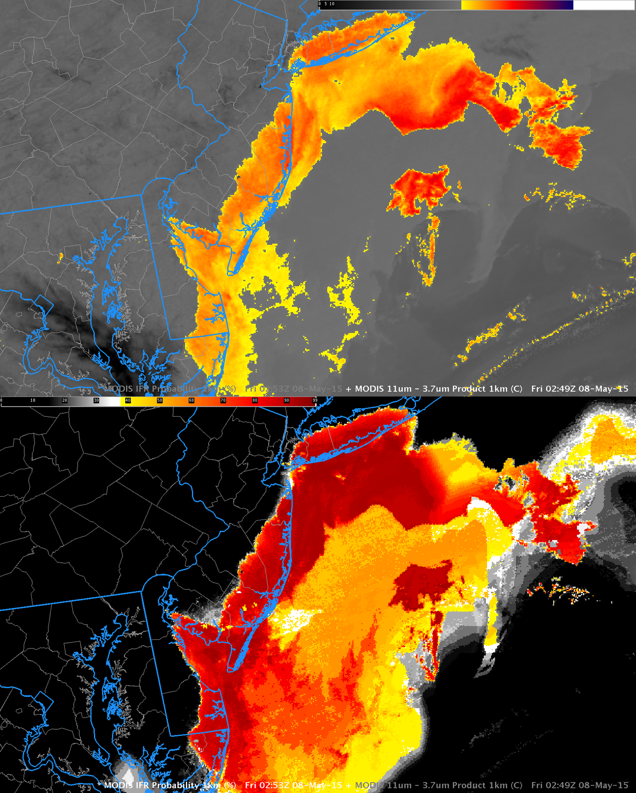
GOES-R IFR Probabilities can also be computed using MODIS data, which data has better spatial resolution than GOES (1-km vs. nominal 4-km). The toggle below of the MODIS brightness temperature difference and the GOES-R IFR Probability shows a very sharp edge to the expanding fog field over New Jersey.

MODISIFR_BTDtoggle_0249_08May2015

MODIS Brightness Temperature Difference (11µm – 3.9µm) and MODIS-based GOES-R IFR Probabilities, ~0250 UTC on 8 May, 2015 (Click to enlarge)

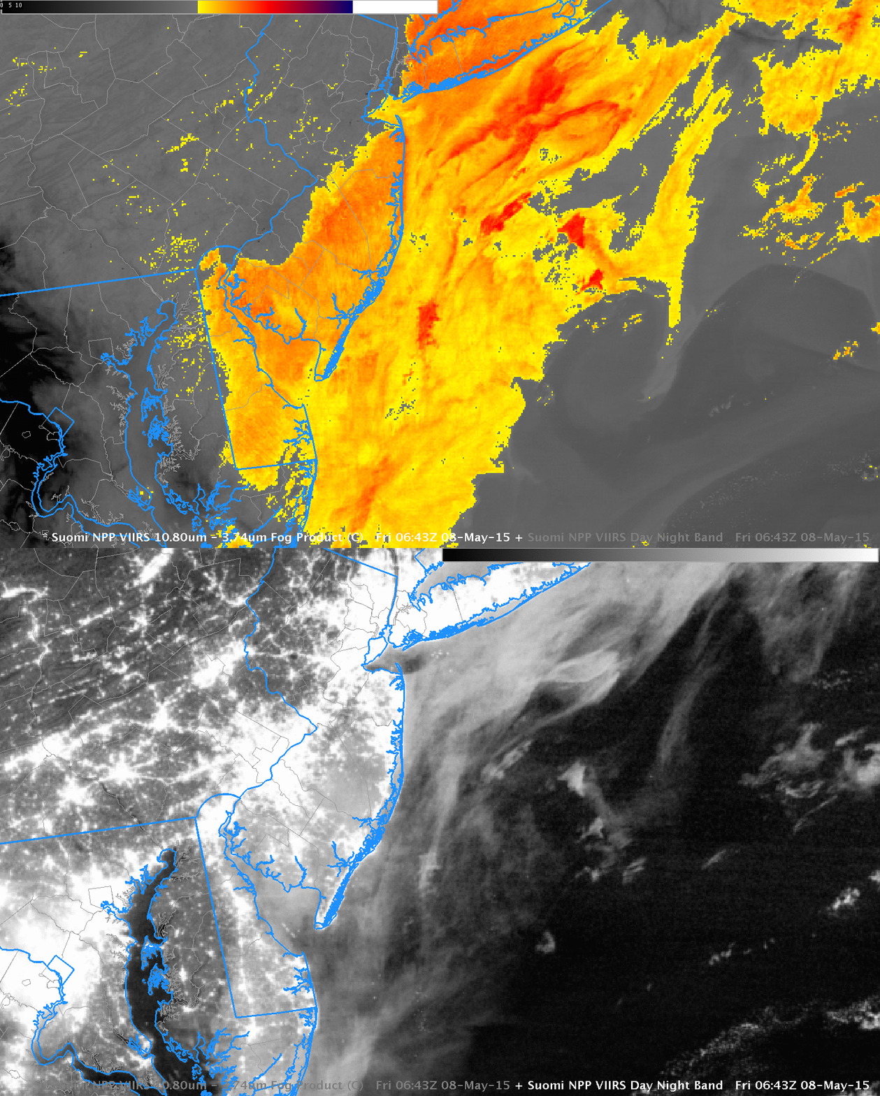
The Gulf Stream is apparent in the Brightness Temperature Difference field above and IFR Probabilities are high over the ocean between the coast and the Gulf Stream. In the absence of observations, how much should those high IFR Probabilities be believed. There is high dewpoint air (mid-50s Fahrenheit) along the East Coast at this time, and advection fog could be occurring, for example. Suomi NPP also overflew the region shortly after midnight. The toggle below, of brightness temperature difference and the Day Night Band confirms the presence of (presumably) low clouds over the cold Shelf Water of the mid-Atlantic bight.

SNPPDNB_BTDtoggle_0643_08May2015

Suomi NPP Brightness Temperature Difference (11.35 µm – 3.74 µm) and Suomi NPP Day Night Band Visible Imagery (0.70 µm) at night, 0643 UTC on 8 May, 2015

Fog along Lake Erie

GOESR_IFR_0800_1400_27Apr2015

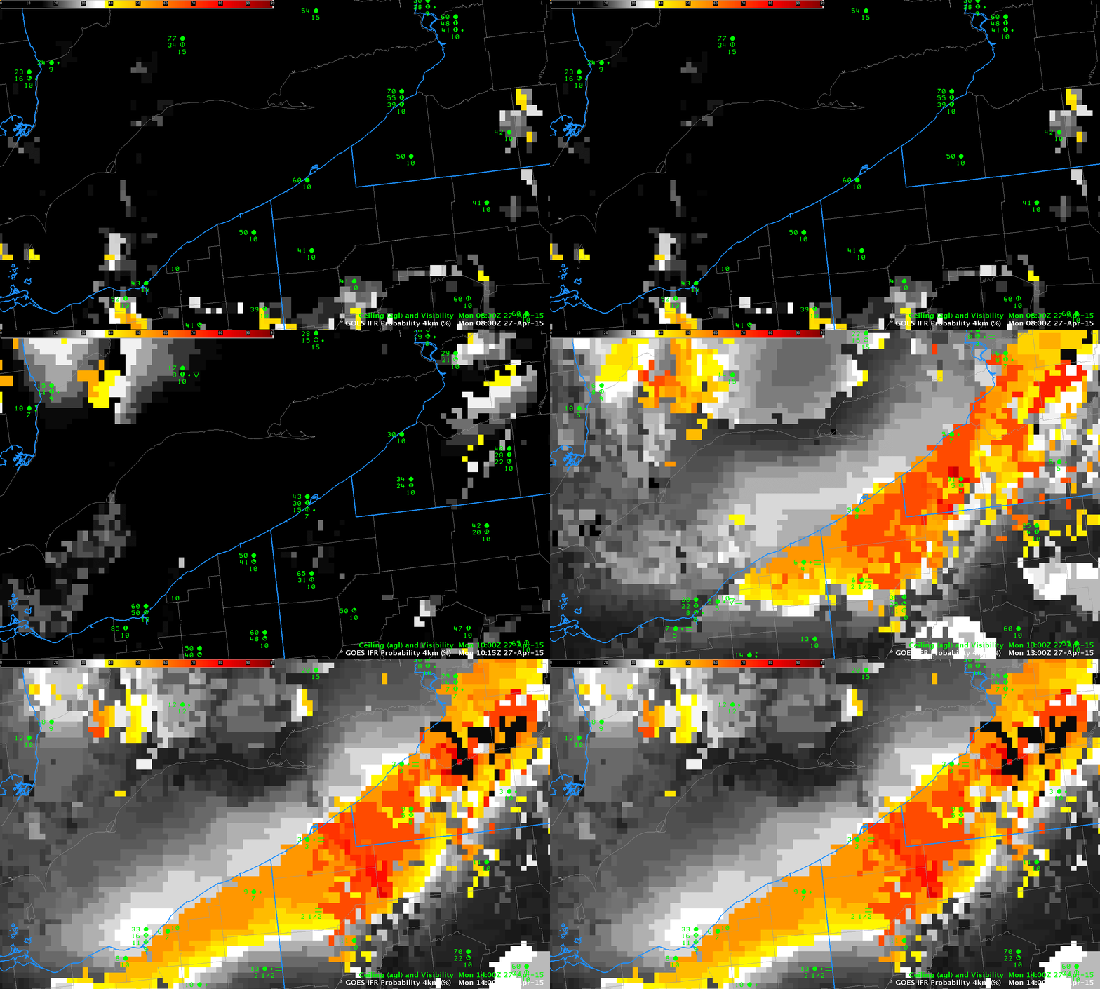
GOES-R IFR Probabilities, 0800 through 1400 UTC on 27 April 2015 (Click to enlarge)

Fog developed along Lake Erie after sunrise on Monday 27 April 2015. The fog and low ceilings were associated with a line of light showers, so multiple cloud layers were present. These layers inhibit satellite detection of fog/low stratus. GOES-R IFR Probabilities, above, computed using GOES-13 Satellite data and Rapid Refresh Model Output show very low probabilities at 0800 and 1015 UTC (stratus clouds are observed); at 1215 UTC, IFR Probabilities increase in the counties adjacent to Lake Erie in Pennsylvania and New York; at 1315 and 1400 UTC, IFR Probabilities are high, and IFR conditions are observed in both Erie PA and Dunkirk NY.

US_11-3.9_Sat_20150427_0400_1000

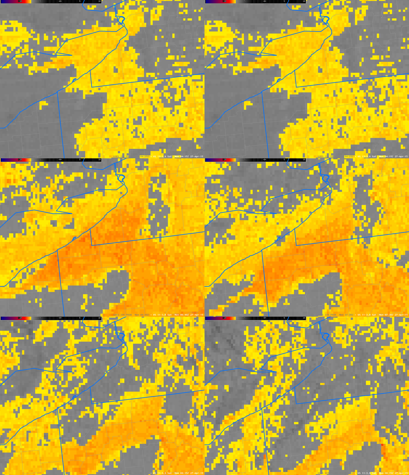
GOES-13 Brightness Temperature Difference Fields, 0400 through 1000 UTC on 27 April 2015 (Click to enlarge)

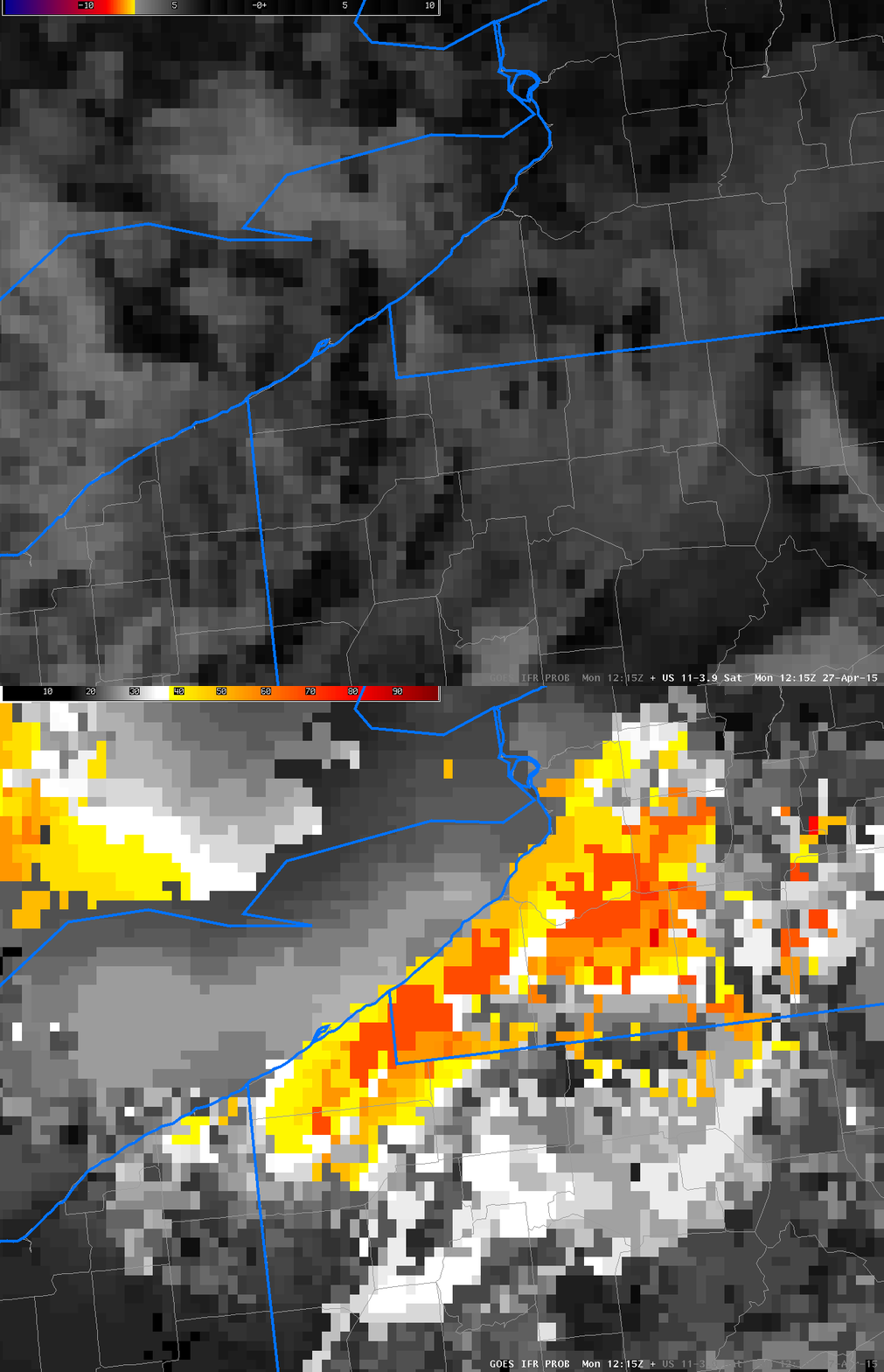
Brightness Temperature Difference fields overnight, above, showed evidence of water-based clouds over much of the area. The fields are moving south, however, leaving the lakeshore behind. The toggle below is of Brightness Temperature Difference and IFR Probability from 1215 UTC. It is far more difficult to relate features in the brightness temperature difference field with reductions in observations at the surface than it is to relate IFR Probability fields with surface observations. Note also that the character of the brightness temperature difference field below has changed because reflected solar radiation at 3.9 µm has become important.

GOES13_IFRPROB_BTD_20150427_1215

Toggle between GOES-R IFR Probability fields and GOES East Brightness Temperature Difference Fields at 1215 UTC on 27 April 2015 (Click to enlarge)