Category Archives: California

Central Valley fog underneath high clouds

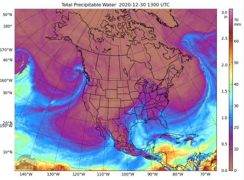
MIMIC Total Precipitable Water, 1300 UTC on 30 December 2020 (Click to enlarge)

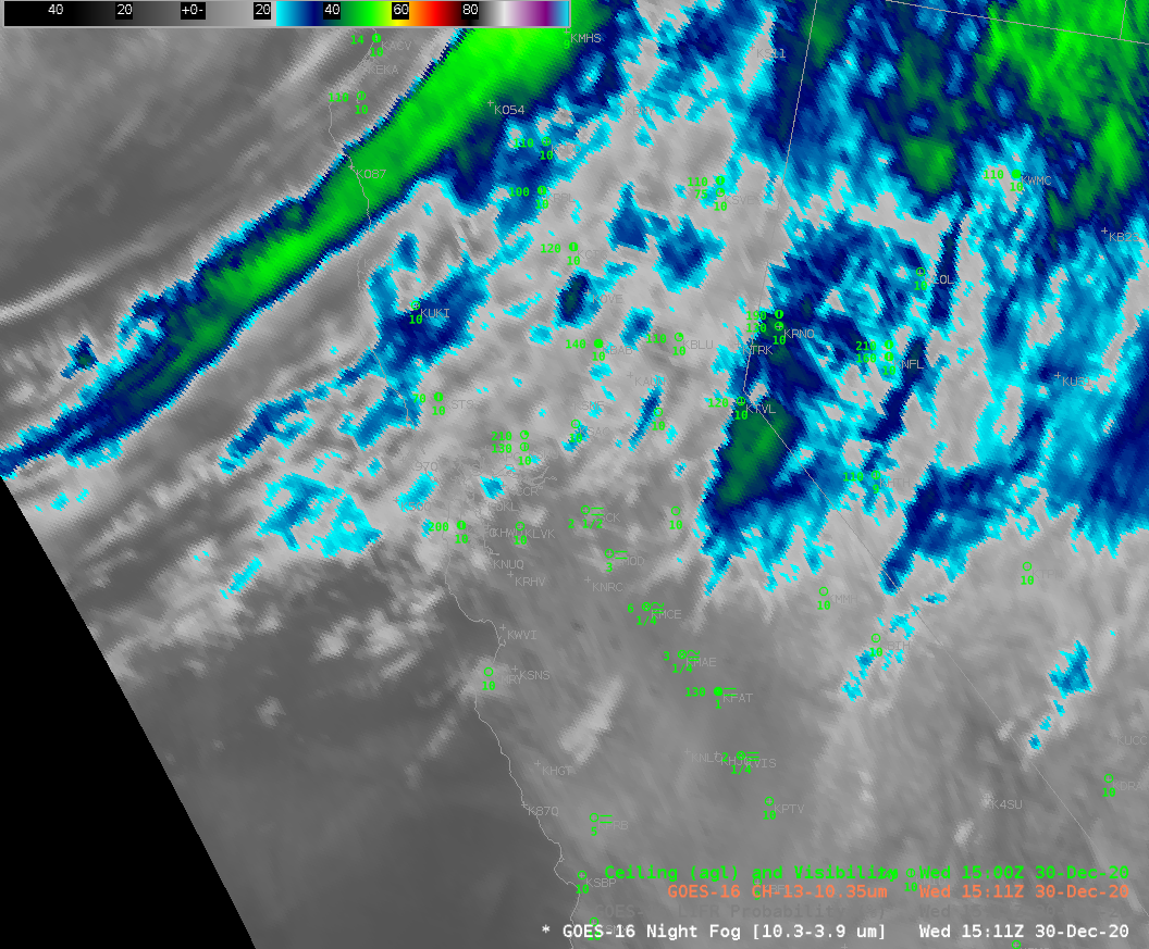
A large storm moving ashore in British Columbia (0900 UTC Map), shown above in MIMIC Total Precipitable Water (from this site), was accompanied by widespread high clouds over much of the Pacific Coast of the United States. The 1511 UTC image, below, shows GOES-16 “clean window” (10.3 µm) infrared imagery, with high clouds apparent.

GOES-16 “Clean Window” infrared imagery (10.3 µm) at 1511 UTC on 30 December 2020

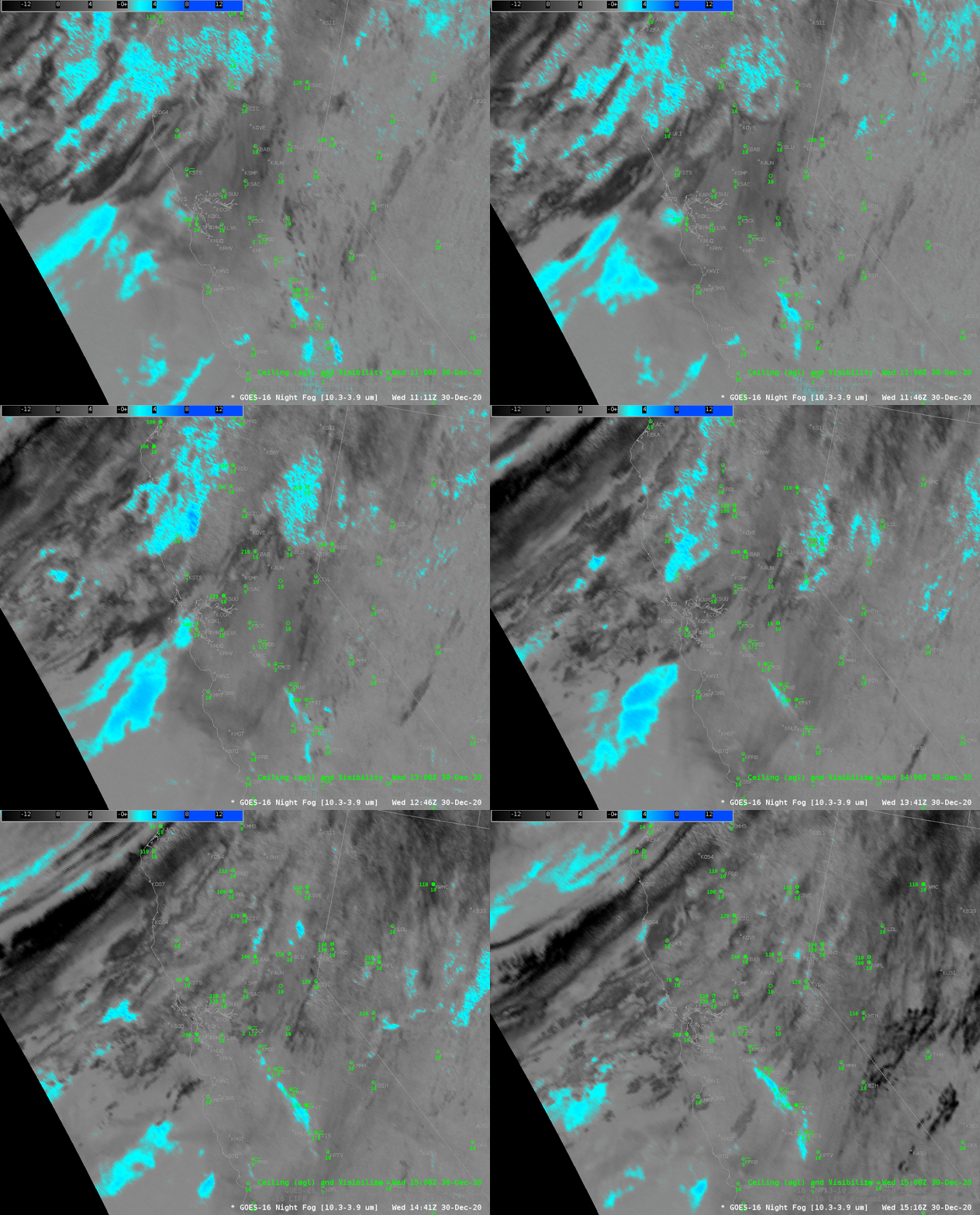
Satellite-only detection of fog/low clouds will be challenged on this day by the abundance of high clouds that block the satellite’s view of low stratus decks. Indeed, the ‘Night Fog’ brightness temperature difference field, below, allows for only periodic glimpses of what is happening near the surface. There are indications of fog — but it is challenging even in the animation to determine the horizontal extent of the fog regions.

GOES-16 ‘Night Fog’ Brightness Temperature Difference (BTD, 10.3 µm – 3.9 µm), 1111 – 1516 UTC on 30 December 2020, along with surface observations of ceilings and visibilities

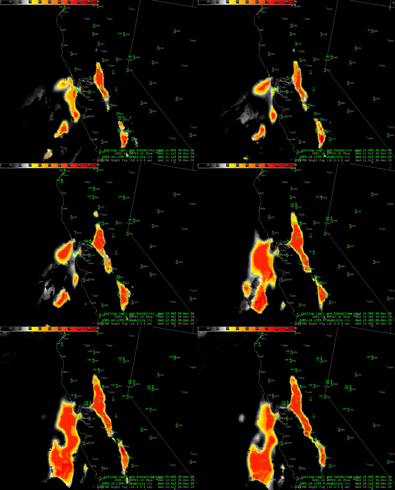
GOES-16 Low IFR Probability fields, below (note: GOES-17 IFR Probability fields are still undergoing testing in preparation for their being deemed operational) highlight two regions of visibility restrictions: One is off the coast of central California, and a another is a narrow ribbon of reduced visibilities in the Central Valley. This case highlights a strength of IFR Probability fields: You get a useful and consistent signal even if high clouds are blocking the satellite view of low clouds. This is because Rapid Refresh Model estimates of low-level saturation are incorporated into the Probability fields.

GOES-16 Low IFR Probability fields, 1116 – 1511 UTC, 30 December 2020, along with surface observations of ceilings and visibilities (Click to enlarge)

Assessing IFR probabilties in regions with multiple cloud layers: San Francisco on 24 June 2020

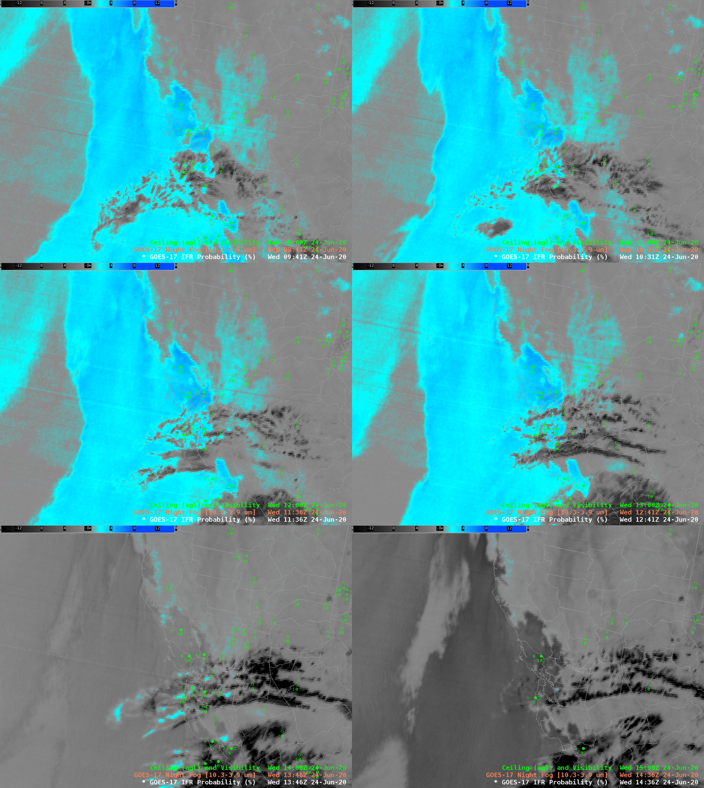
GOES-17 ‘Night Fog’ Brightness Temperature Difference (10.3 µm – 3.9 µm) 0941 UTC – 1436 UTC, 24 June 2020 (Click to enlarge)

GOES-17 ‘Night Fog’ Brightness Temperature Difference imagery, above, shows a stratus deck (cyan and blue in this default AWIPS enhancement) off the central California coast. Higher clouds (grey and black in the enhancement) are drifting over San Francisco bay, obscuring the GOES-17 satellite’s view of low clouds. These high clouds can present a challenge to aviation forecasters for San Francisco’s airport, and important airline hub because the nature of low clouds cannot be determined. (Note the striping in the image is an artifact of GOES-17’s malfunctioning Loop Heat Pipe). This animation also shows the effect of increasing amounts of reflected solar radiation on the Night Fog Brightness Temperature Difference signal.

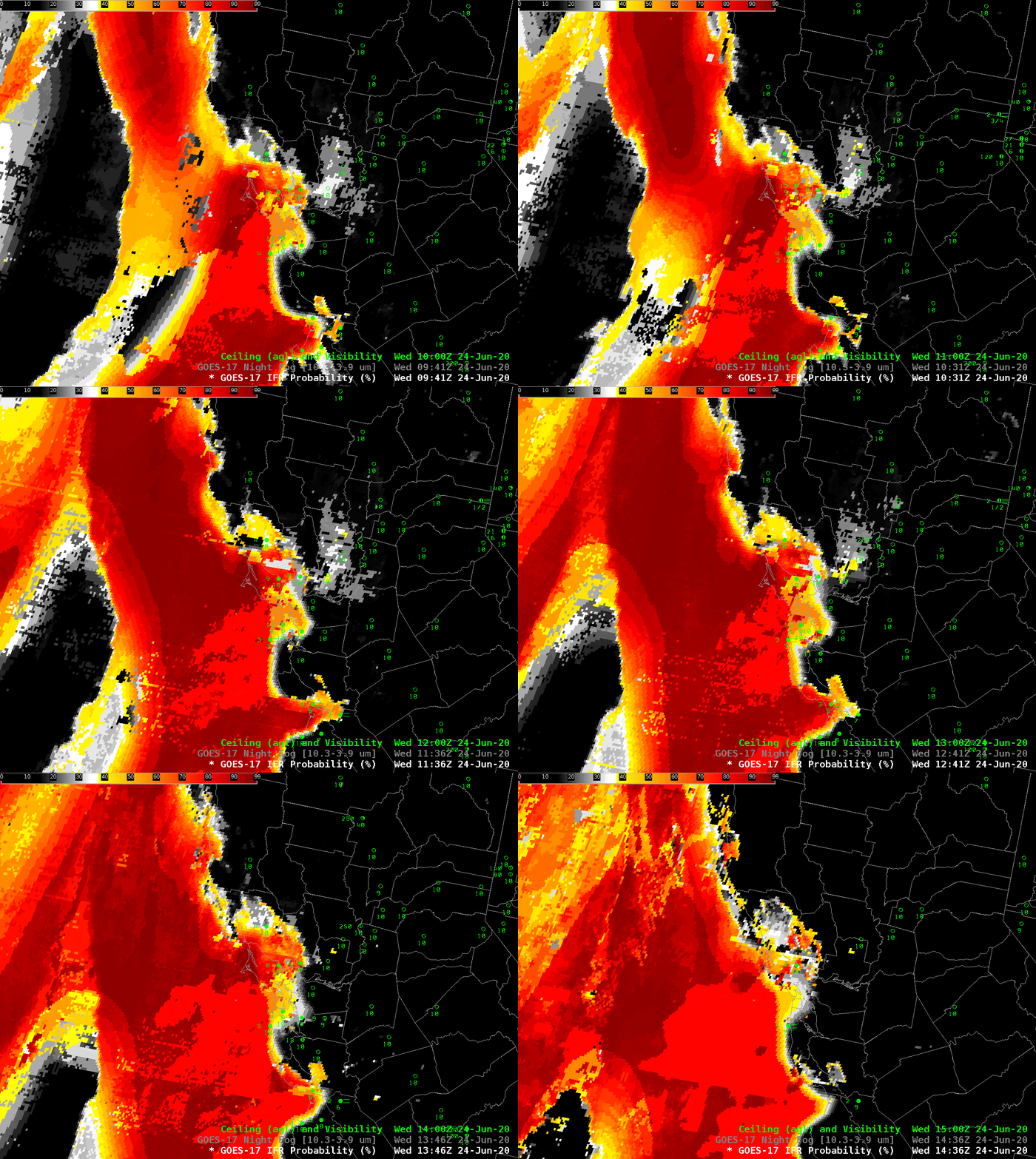
GOES-17 IFR Probability fields, below, augment information at low levels by using model (Rapid Refresh) estimates of low-level saturation (as might be found in low stratus) in the computation of IFR Probability. The animation below shows that SFO was in a region of high — but not very high — IFR Probabililty. Note also how the signal is constant through the sunrise at the end of the animation.

The airport (KSFO) did not report IFR conditions on this morning.

GOES-17 IFR Probability fields, 0941 – 1436 UTC, 24 June 2020 (Click to enlarge)

Detecting low ceilings over California

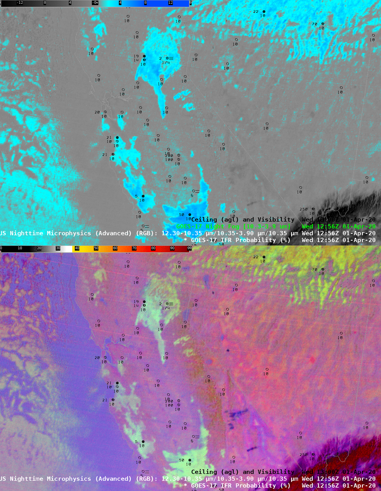
GOES-17 Night Fog Brightness Temperature Difference (10.3 µm – 3.9 µm) and Night Time Microphysics RGB, 1256 UTC on 01 April 2020 (Click to enlarge)

Detecting stratus at night, and thereby inferring the presence of fog, usually involves the Night Fog Brightness Temperature Difference (10.3 µm – 3.9 µm) field that identifies clouds made up of water droplets owing to the droplets’ different emissivity properties at 10.3 µm (droplets emit energy at that wavelength mostly as a blackbody) and at 3.9 µm (droplets do no emit energy at that wavelength as a blackbody). This difference field is a crucial component in the Night Time Microphysics Red-Green-Blue (RGB) Product as evinced in the toggle above. The regions shown to have low clouds (blue and cyan in the Brightness Temperature Difference field, pale yellow in the RGB) are not necessarily those regions with IFR conditions, i.e., where fog and low ceilings are present. The satellite can sense the top of the cloud, but it is a challenge to infer from the satellite data alone where the cloud base sits.

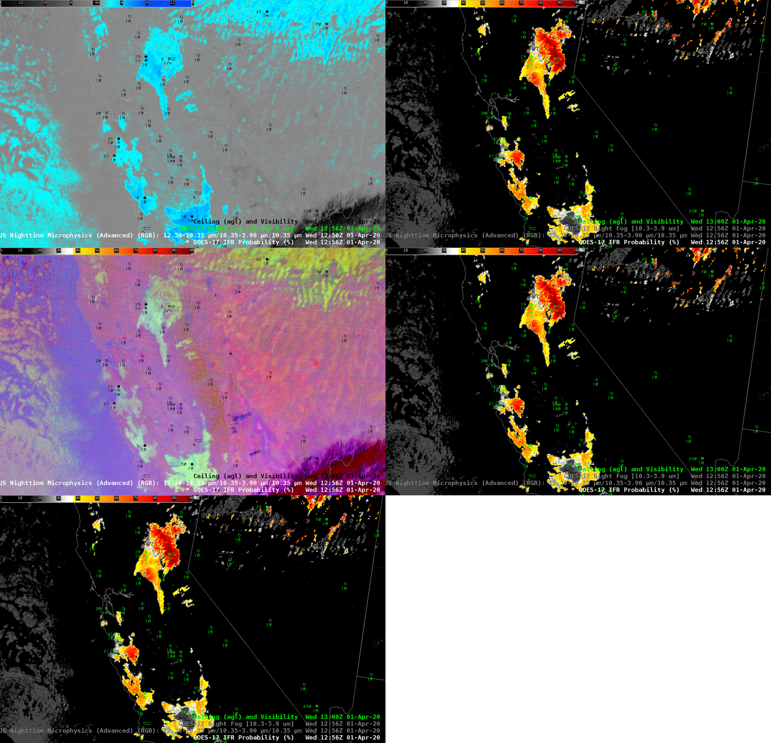
GOES-R IFR Probability fields combine satellite information with model estimates of low-level saturation. An accurate model simulation can allow the product to highlight regions of low ceilings (where fog is more likely) and screen out mid-level stratus. Consider the toggle below, and note how is emphasizes regions where observations show low ceilings and/or reduced visibilities (Blue Canyon airport northwest of Lake Tahoe and Paso Robles airport). Note also how the signal at Bakersfield, at the southern end of California’s Central Valley, is de-emphasized.

GOES-R IFR Probability fields provide a consistent signal for low ceilings and reduced visibility. The fields marry the strengths of satellite detection and model data.

GOES-17 Night Fog Brightness Temperature Difference (10.3 µm – 3.9 µm), GOES-17 IFR Probabilities, and GOES-17 Night Time Microphysics RGB, 1256 UTC on 01 April 2020 (Click to enlarge)

GOES-17 IFR Probability over San Francisco

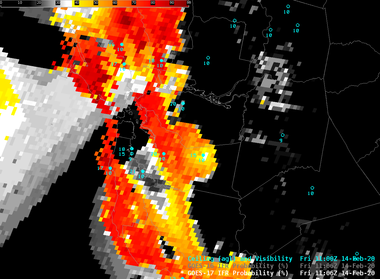
GOES-17 IFR Probability over San Francisco, 1106 UTC, 14 February 2020, along with surface observations of ceilings and visibility (Click to enlarge)

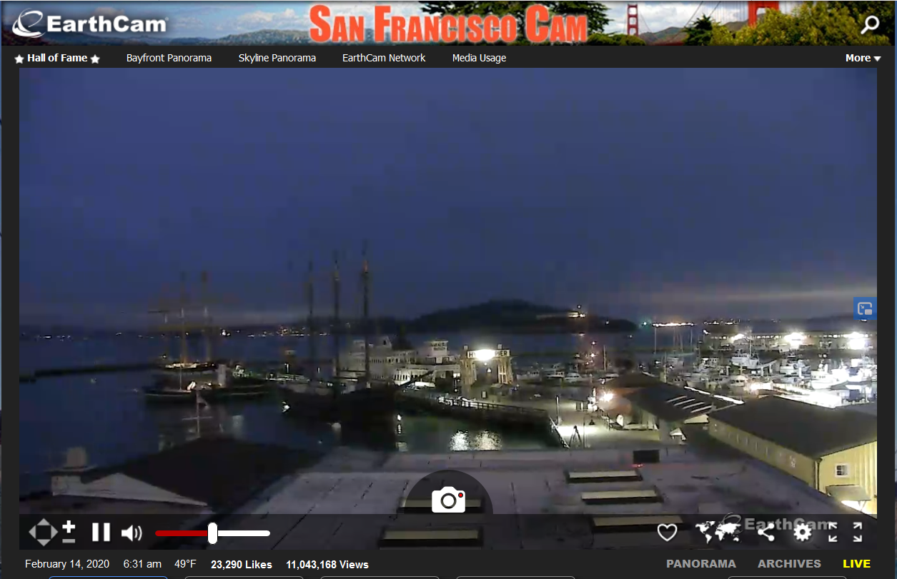
The Cooperative Institute for Meteorological Satellite Studies (CIMSS) is (as noted in this blog post) testing GOES-17 IFR Probability fields in the AWIPS environment in preparation for their deployment to interested offices (via an LDM feed). The GOES-17 field, above, at 1106 UTC, suggests stratus offshore of San Francisco but higher ceilings over the city and the bay. Webcam views of the city (source), and of Alcatraz Island (source), below, from around 630 AM PST, also suggest relatively high ceilings over the city and the bay.

Webcam view of Alcatraz Island in San Francisco Bay, ca. 6:30 AM PST 14 February 2020

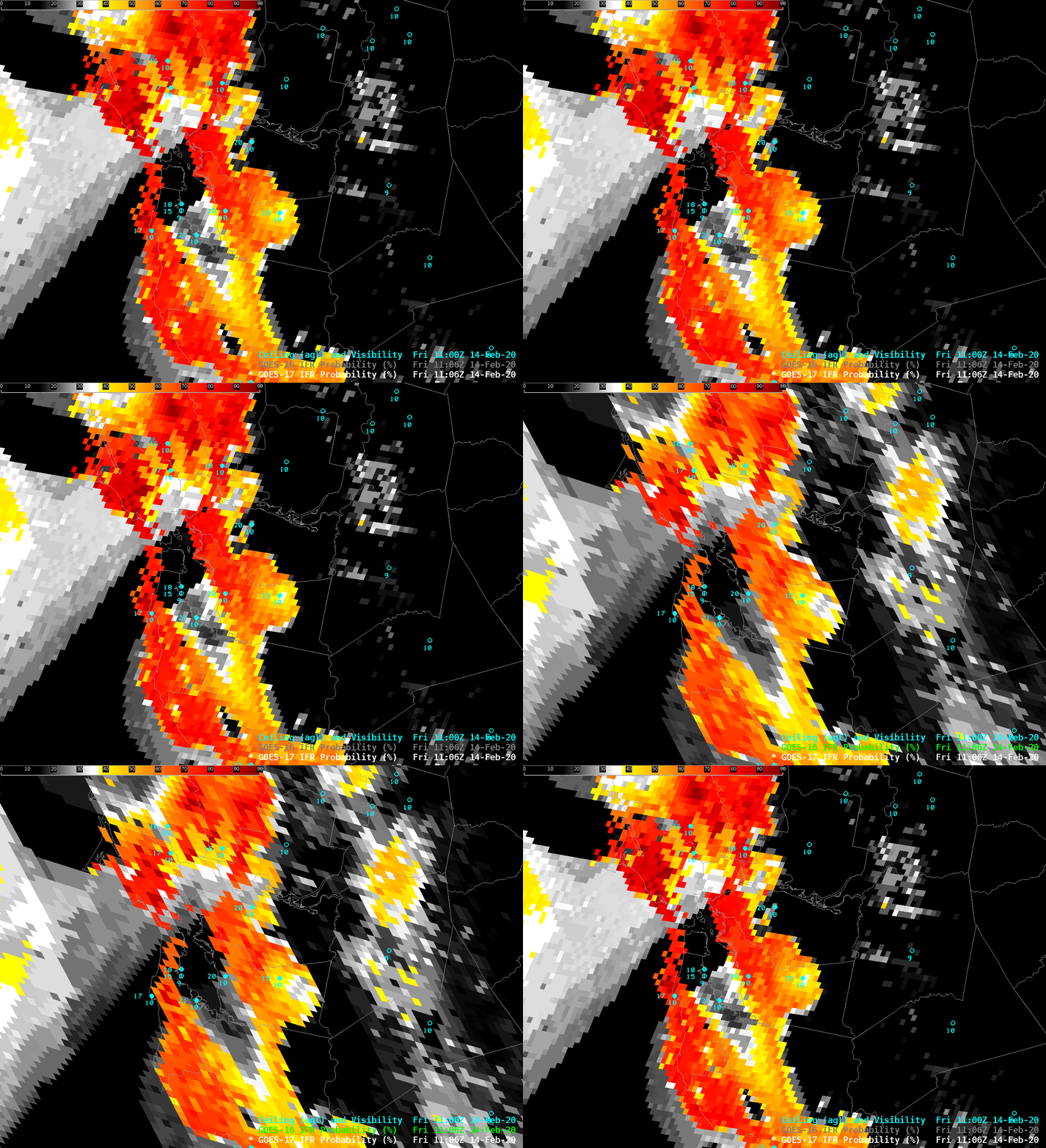
GOES-16 is also providing IFR Probability over the west coast of the United States. The toggle below between GOES-17 and GOES-16 shows how the oblique view from GOES-16 and the effects of parallax can perhaps place the probability in the wrong place. Parallax errors shift the clouds towards the sub-satellite point. Parallax effects can be explored at this website.

GOES-17 and GOES-16 IFR Probability fields, 1106 UTC on 14 February 2020 (Click to enlarge)

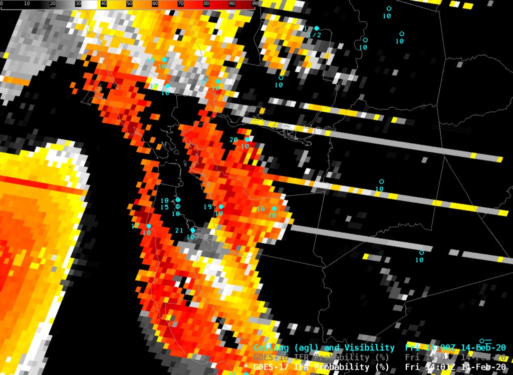
The GOES-17 Advanced Baseline Imager (ABI) is currently showing the effects of inadequate imager cooling by the faulty Loop Heat Pipe on board the spacecraft. At times between 1100 and 1500 UTC, as shown below for 1401 UTC, stripes will appear in the IFR Probability field. Manifestations of the Loop Heat Pipe issue will continue with increasing impact into early March, at which time Eclipse Season will mitigate the issue until April.

GOES-17 IFR Probability over San Francisco, 1401 UTC, 14 February 2020, along with surface observations of ceilings and visibility (Click to enlarge)

GOES-17 IFR Probability fields are available over the CONUS domain at this website.

What GOES-16 Resolution will bring to IFR Probability

GOES-16 Brightness Temperature Difference field (10.3 µm – 3.9 µm) at 1247 UTC on 5 July 2017 (Click to enlarge)

GOES-16 data posted on this page are preliminary, non-operational data and are undergoing testing

GOES-R IFR Probabilities are computed using Legacy GOES (GOES-13 and GOES-15) and Rapid Refresh model information; GOES-16 data will be incorporated into the IFR Probability algorithm in late 2017

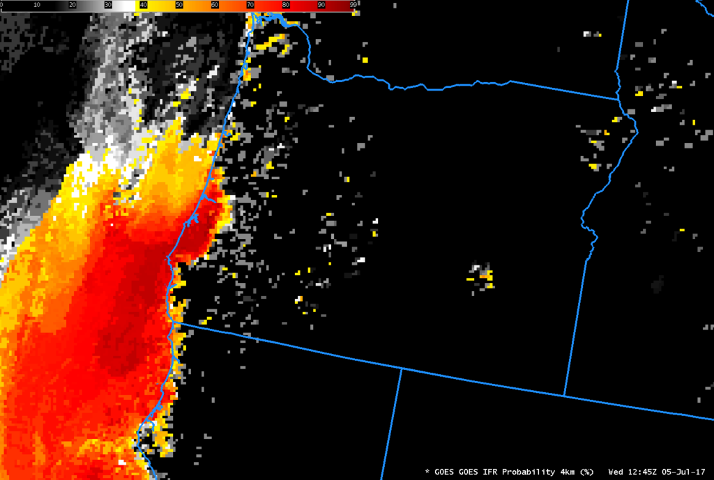
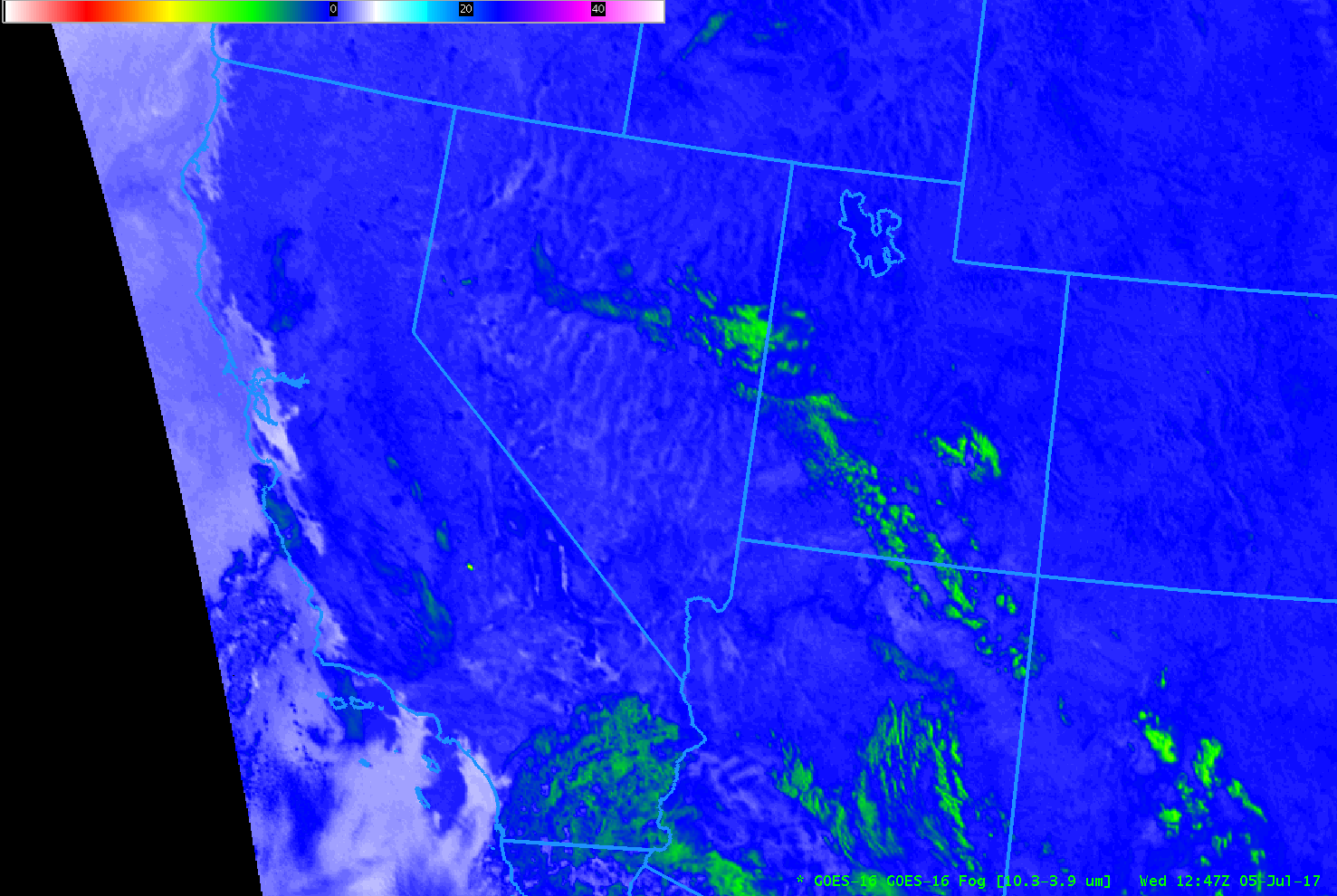
GOES-R IFR Probability fields continue to be created using legacy GOES (GOES-13 and GOES-15) data. This is slated to continue through late 2017. The toggle above, over Oregon, hints at how the change in resolution in GOES-16, even far from the sub-satellite point, will likely improve GOES-R IFR Probability performance in regions where topography can constrain low clouds and fog.  The GOES-16 Brightness Temperature Difference field, above, is color enhanced so that positive values (that is, where the brightness temperature at 10.3 µm is warmer than the 3.9 µm brightness temperature, which regions indicate cloud tops composed of water droplets, i.e., stratus) are whitish — and the data shows stratus/fog along the Oregon Coast, with fingers of fog advancing up small valleys.  The image below shows the GOES-R IFR Probability field for the same time (Click here for a toggle).

GOES-R IFR Probability fields show strong probabilities where the Brightness Temperature Difference field above is indicating low clouds.  This is not surprising as the morning fog on this date was not overlain by higher clouds.  However, the resolution inherent in the legacy GOES (inferior resolution compared to GOES-16), shows up plainly as a blocky field.  When GOES-R IFR Probability fields are computed using GOES-16 data, the IFR Probability field resolution will match the GOES-16 resolution.  (Click here for a aviationweather.gov observation of IFR / Low IFR conditions on the morning of 5 July).

GOES-R IFR Probability field computed from GOES-15 data at 1245 UTC on 5 July 2017 (Click to enlarge)

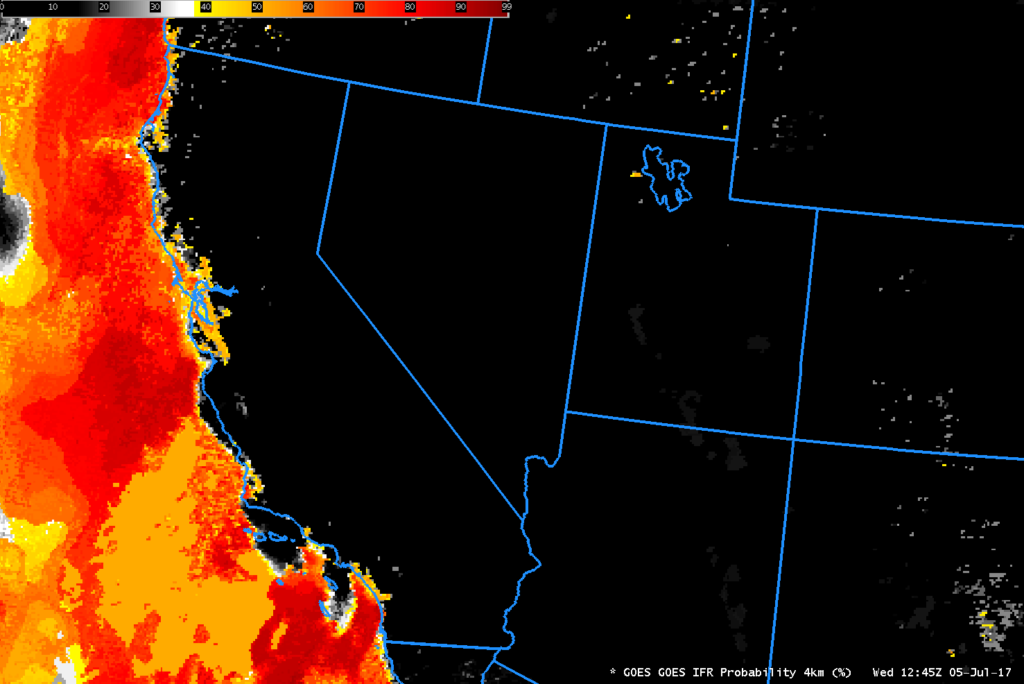
A similar set of figures for California at the same time is below.  The toggle is here, and the aviationweather.gov screen capture is here.

GOES-16 Brightness Temperature Difference field (10.3 µm – 3.9 µm) at 1247 UTC on 5 July 2017 (Click to enlarge)

GOES-R IFR Probability field computed from GOES-15 data at 1245 UTC on 5 July 2017 (Click to enlarge)


Marine Stratus over southern California

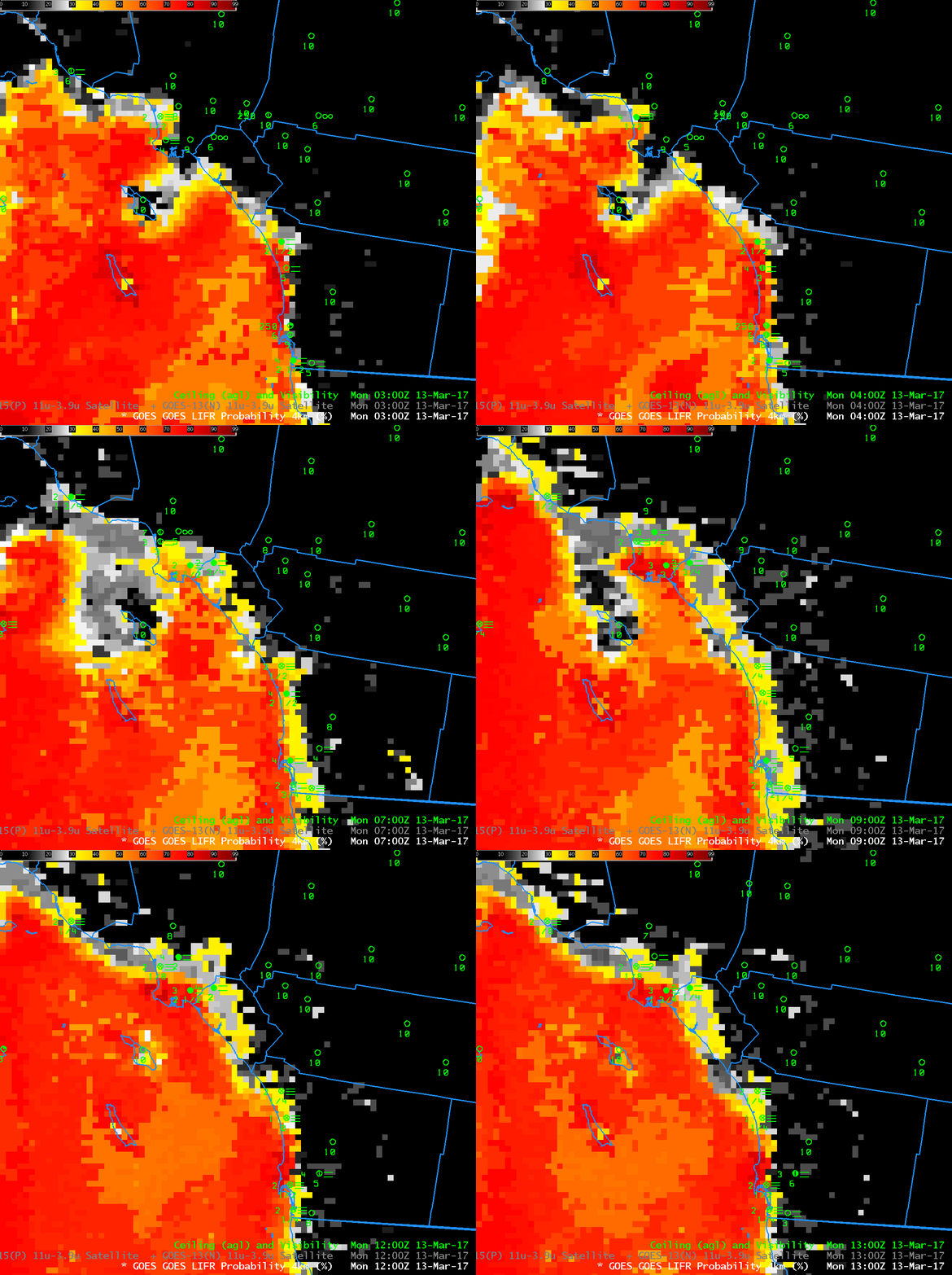
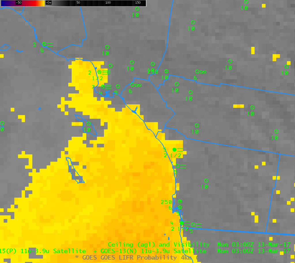
GOES-R IFR Probability, hourly from 0300 to 1300 UTC, 13 March 2017 (Click to enlarge)

Note:  GOES-R FLS products are currently derived from GOES-13 and GOES-15 data.  A GOES-16 version of the GOES-R FLS products will not be available until later in 2017.

IFR Conditions developed early on March 13th 2017 as Marine Stratus moved over the southern California. This is a typical occurrence that nevertheless requires timely monitoring because of the impact of fog on transportation. The Brightness Temperature Difference fields, below, show the tops of the clouds. Water clouds do not emit 3.9 µm radiation as a blackbody, but they do emit 10.7 µm radiation nearly as a blackbody. Result: Inferred brightness temperatures (a computation that assumes blackbody emission from the source) are cooler and 3.9 µm than at 10.7 µm, and a difference field will highlight clouds made up of water droplets, i.e., stratus. If the stratus is at the surface, fog is a result. Low IFR Probability fields, above, include surface information in the form of low-level relative humidity fields from the Rapid Refresh model. Only where saturation near the surface is indicated by the model will Low IFR Probabilities be large.

In the animation above, IFR conditions develop along the coast and penetrate inland as Low IFR Probabilities increase.  Probabilities are decreasing by 1300 UTC.

IFR and Low IFR Conditions are shown in this plot from the Aviation Weather CenterThis toggle, from 0300 UTC, shows both Low IFR Probability and IFR Probability.  As might be expected, IFR Probabilities exceed Low IFR Probabilities

GOES-15 Brightness Temperature Difference (3.9 µm – 10.7 µm) Fields, hourly from 0300 to 1300 UTC on 13 March 2017 (Click to enlarge)

IFR Probability vs. Brightness Temperature Differences over California

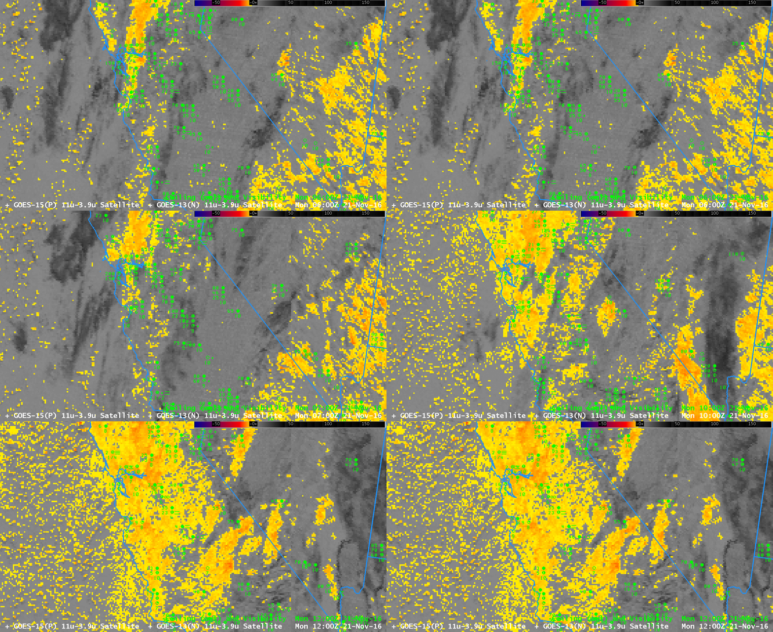
btd_21nov2016anim_0600_1200

GOES-15 Brightness Temperature Difference Fields (3.9 µm – 10.7 µm), 0600-1200 UTC on 21 November 2016 (Click to enlarge)

GOES-15 Brightness Temperature Difference fields (3.9 µm – 10.7 µm, above, from 0600-1200 UTC on 21 November) can detect low clouds because water-based clouds do not emit 3.9 µm radiation as a blackbody, but they do emit 10.7 µm radiation as a blackbody. Consequently, the brightness temperature computed from 3.9 µm radiation is cooler than that computed by 10.7 µm radiation. The animation above depicts two challenges that arise from using brightness temperature difference fields. If mid-level clouds or cirrus are present, the satellite cannot view the low-level clouds that might be associated with fog. That is the case above over the San Joaquin Valley at the start of the animation. Later on, as the higher clouds move out, a strong signal develops everywhere. Brightness Temperature Difference fields are not giving useful information because alone they cannot distinguish between mid-level stratus and low stratus/fog.

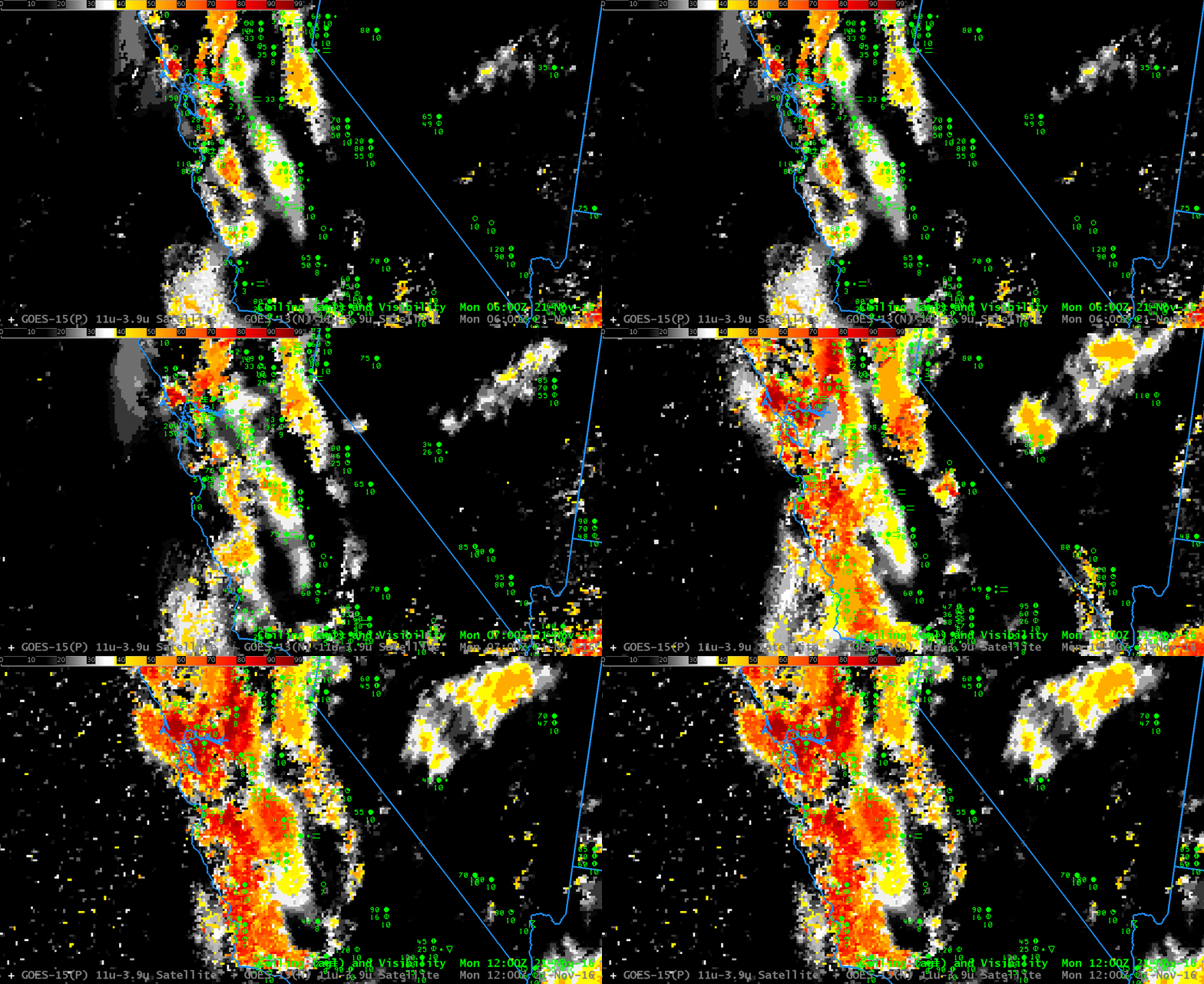
In contrast, the GOES-R IFR Probability fields suggest the likelihood of IFR conditions in three distinct regions: Along the Sierra Nevada, where terrain is likely to rise up into the Cloud Base, in the San Joaquin Valley, and along the coastal range. Largest values of IFR Probability do occur where (or near where) ceilings and visibilities are reduced and can help a forecaster restrict interest to where it is actually warranted. IFR Probability fields combine satellite observations of stratus with Rapid Refresh model predictions of low-level saturation, so IFR Probability fields are better able to highlight regions of low stratus and fog.

ifrprob_21nov2016anim_0600_1200

GOES-R IFR Probability Fields, 0600-1200 UTC on 21 November 2016 (Click to enlarge)

Multiple Cloud Layers and Topography

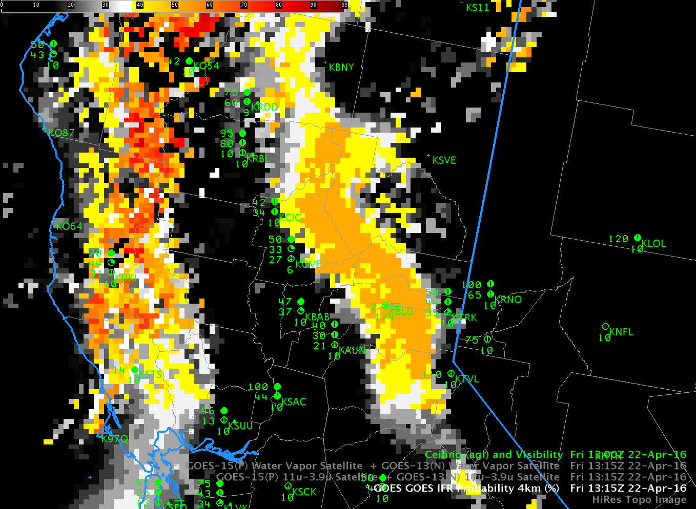
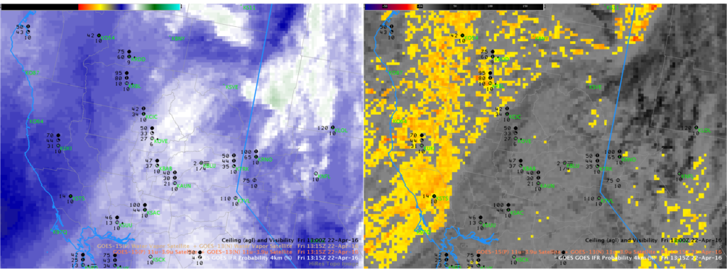
IFR_1315_22Apr2016

GOES-R IFR Probability Fields, 1315 UTC on 22 April 2016, along with surface observations of ceilings and visibilities (Click to enlarge)

The 1315 UTC image of GOES-R IFR Probabilities, above, shows an axis of higher probabilities aligned with the topography of the Sierra Nevada. Note that Blue Canyon (KBLU) is the sole station reporting IFR Conditions. Did conventional satellite data capture this event? The Water Vapor (6.5µm) and Brightness Temperature Difference fields (10.7µm – 3.9µm), below, do not show evidence of low clouds;  indeed, the cirrus signature in the water vapor must mask any satellite observation of low clouds banked along the Sierra Nevada. Thus a fused product that combines model data and satellite data (such as IFR Probability fields) must be used, and the relatively flat nature of the IFR Probability field above confirms that Rapid Refresh information on low-level saturation is the reason why IFR Probability values are elevated along the mountains.

WV_BTD_1315_22Apr2016

GOES-15 Water Vapor (6.5 µm), left, and GOES-15 Brightness Temperature Difference Field (10.7 µm – 3.9 µm), right, at 1315 UTC 22 April 2016 (Click to enlarge)

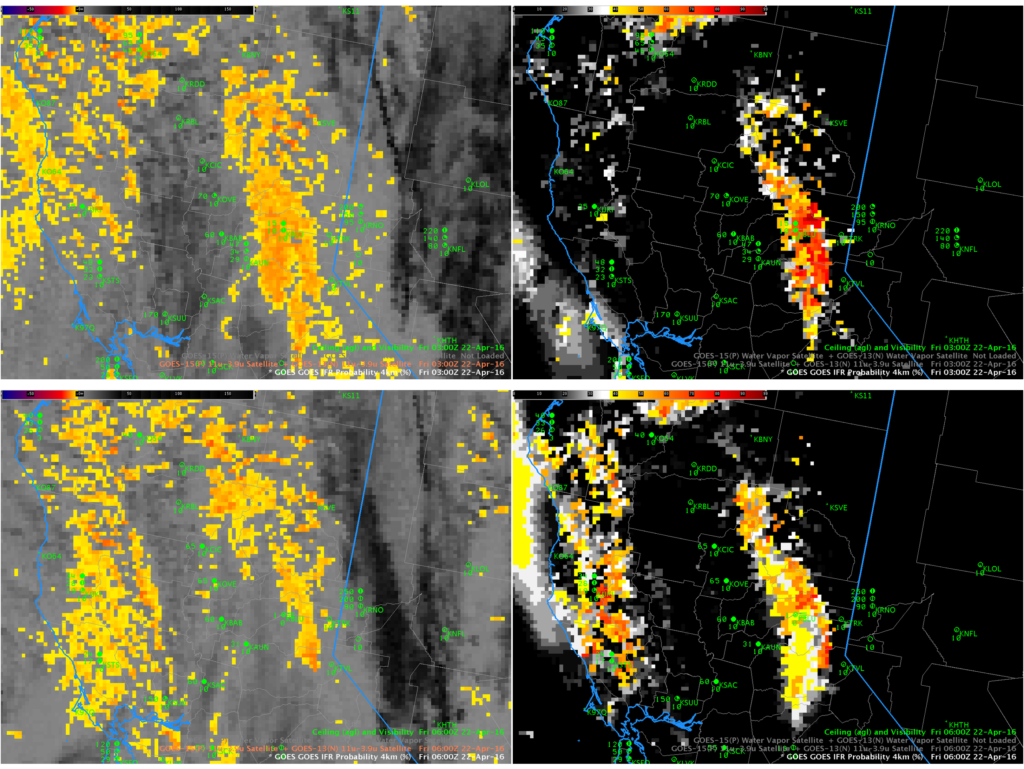
IFR Probability Fields earlier in the night did have a satellite component to them. The values at 0300 and 0600, below, show the gradual encroachment of cirrus from the south and west over the low clouds along the Sierra Nevada. After 0600 UTC, only model data were used over the Sierra as high-level cirrus blocked the satellite view.

IFR_BTD_03_06_22Apr2016

Brightness Temperature Difference (10.7µm – 3.9µm) Fields (Left) and GOES-R IFR Probaility Fields (Right) from 0300 (Top) and 0600 (Bottom) on 22 April 2016 (Click to enlarge)

IFR Probability and Topography

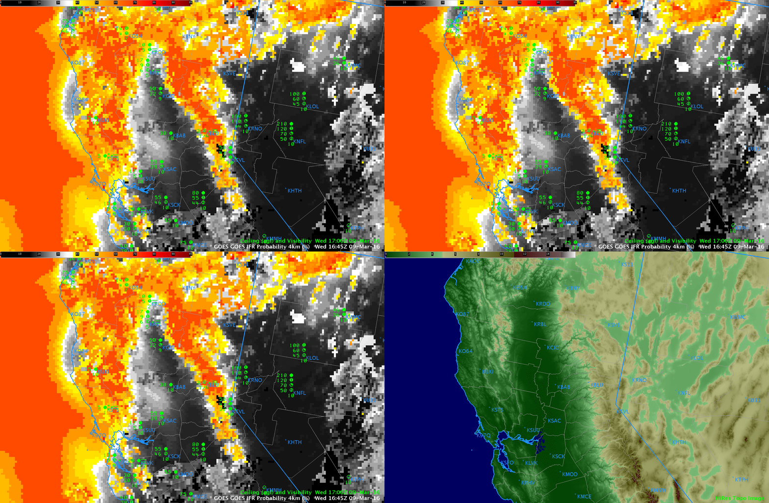
GOES_IFR_15z_9March_Topo.toggle

It is not unusual for land to ascend into the clouds in regions where Moutains abut large valleys or gently sloping plains.  This is especially apparent in California on either side of the Central Valley.  The toggle above shows IFR Probability fields at 1645 UTC on 9 March, and a high-resolution topographic image.  High IFR Probabilities are well correlated with high terrain. This is something a user must consider when using the product.

Fog in California’s Central Valley

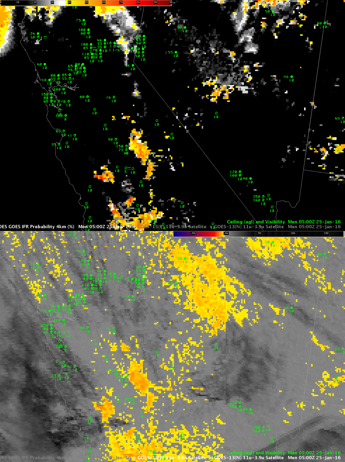
GOES_IFR_BTD_0500_25Jantoggle

GOES-R IFR Probability Fields and GOES Brightness Temperature Difference (10.7 µm – 3.9 µm) at 0500 UTC, 25 January 2016 (Click to enlarge)

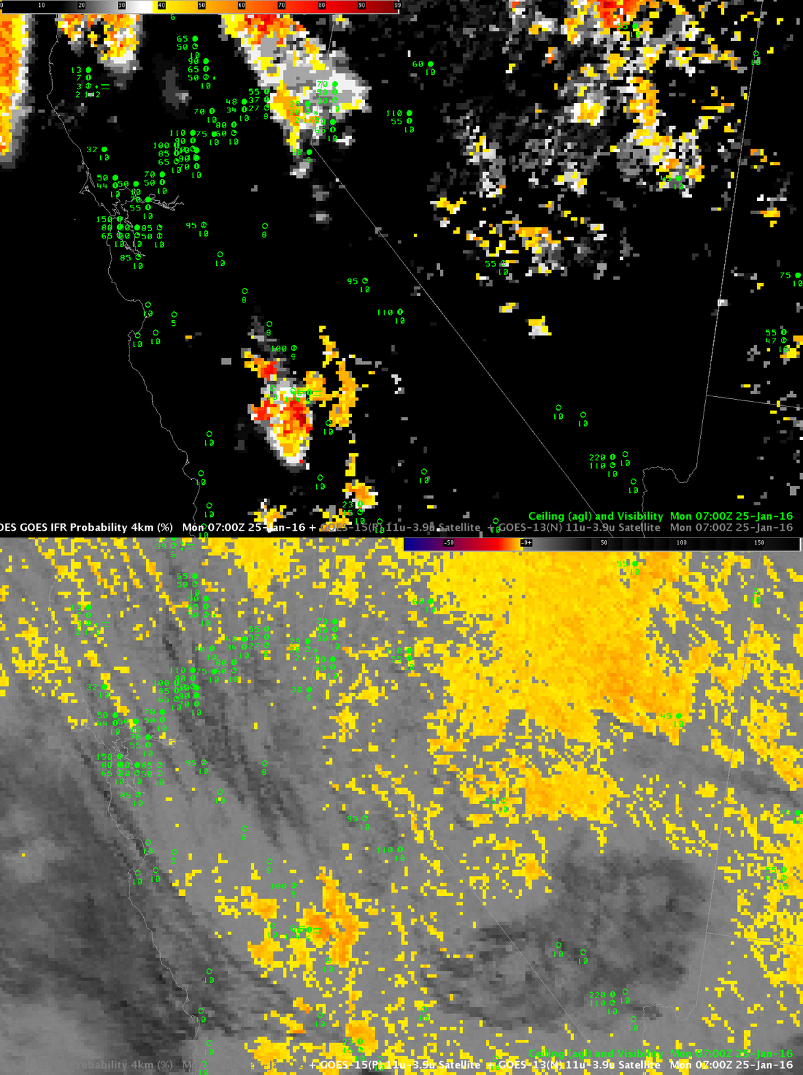
Fog developed over California’s central Valley during the early morning of 25 January 2016.  The toggle above shows the GOES-R IFR Probability field and the GOES Brightness Temperature Difference field at 0500 UTC, before any IFR conditions were reported. Note that the brightness temperature difference field reports large regions of water-based clouds over Nevada — IFR Probability fields screen out this region because low-level saturation is not occurring in the Rapid Refresh Model.  The inference should be that any cloud present there is mid-level stratus rather than fog. That screening of water-based clouds continues at 0700 UTC, below.  Around Hanford, IFR Probability values have increased as ceilings and visibilities have lowered.
GOES_IFR_BTD_0700_25Jantoggle

As above, but at 0700 UTC (Click to enlarge)
GOES_IFR_BTD_0900_25Jantoggle

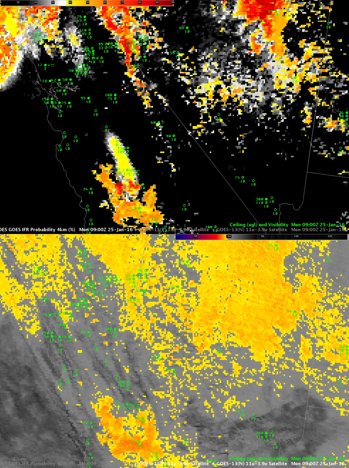
As above, but at 0900 UTC (Click to enlarge)

By 0900 UTC, above, high clouds have moved over Hanford (shown as dark streaks in the brightness temperature difference field enhancement) where IFR conditions are occurring. IFR Probability fields correctly continue to maintain a strong signal around Hanford even though brightness temperature difference fields cannot detect low clouds because of the presence of high clouds. Thus, GOES-R IFR Probability in that region is controlled by Rapid Refresh Model output that successfully predicted the presence of low-level saturation. By 1100 UTC, below, the high clouds have moved south, and GOES-R IFR Probability values rebound. When both Satellite data and Model data can be used as predictors, IFR Probability field values are larger than when only satellite data or only model data are used as predictors.

GOES_IFR_BTD_1100_25Jantoggle

As above, but at 1100 UTC (Click to enlarge)
GOES_IFR_BTD_1300_25Jantoggle

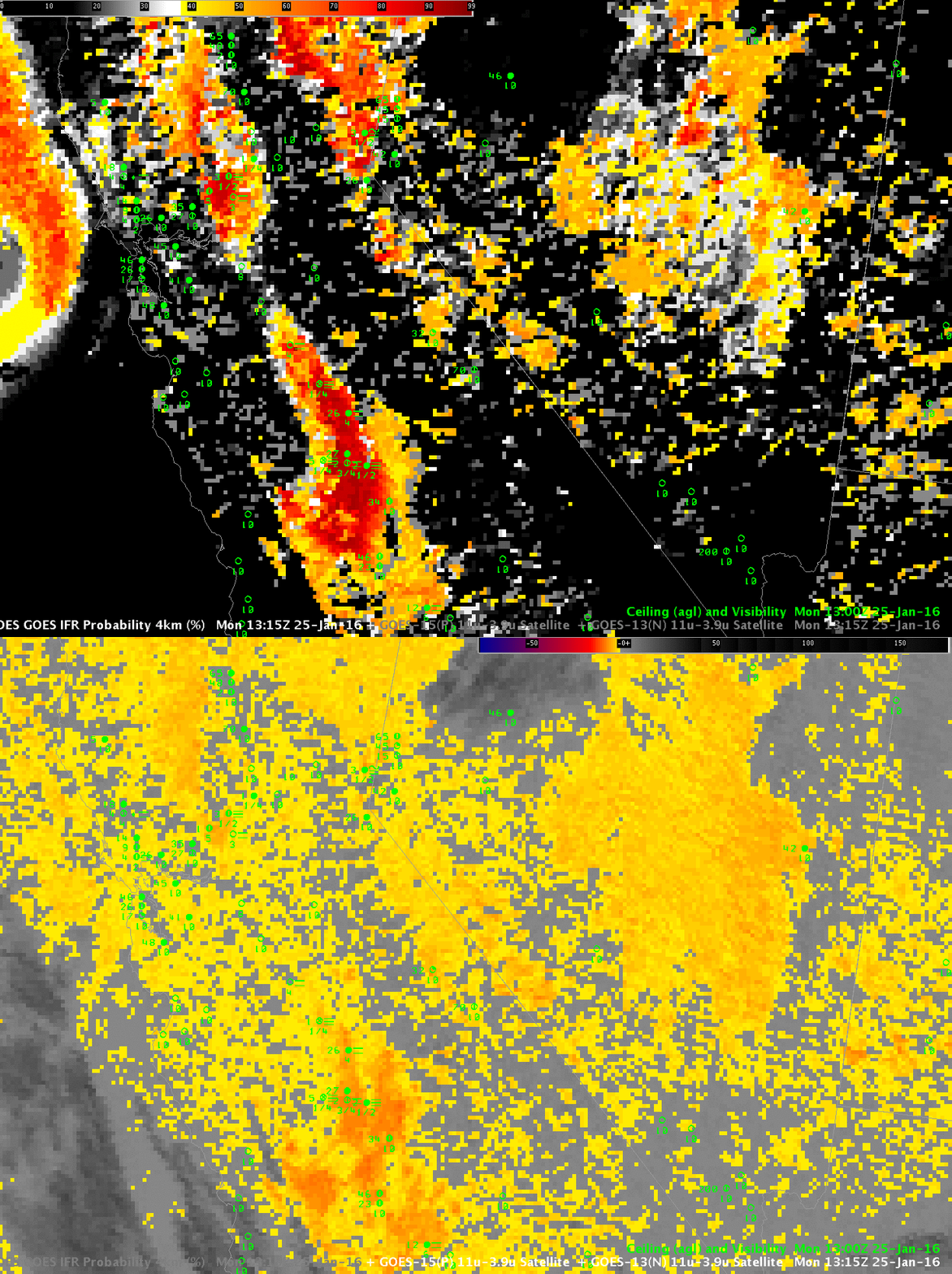
As above, but at 1300 UTC (Click to enlarge)

By 1300 UTC, the region of IFR Conditions near Hanford has expanded — and a second region has developed closer to Sacramento.  IFR Probability fields continue to screen out regions that the brightness temperature difference field alone suggests are regions of low stratus.  Surface-based observations do show regions of mid-level stratus over Nevada, around San Francisco, and over northern California, three regions where the brightness temperature difference signal is strong.  The higher terrain of the Sierra Nevada to the east of the Central Valley also shows higher IFR Probability as might be expected where terrain rises up into mid-level stratus.

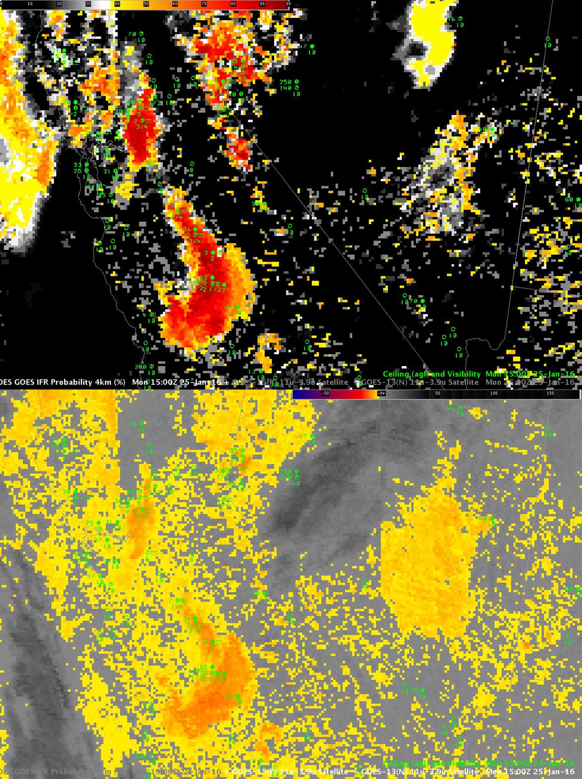
The 1500 UTC images, below, continue these trends.  By 1700 UTC, at bottom, there is enough solar radiation reflecting off the clouds that the brightness temperature difference has flipped sign.  The IFR Probability field, however, has a consistent signal over the persistent region of low clouds/fog around Hanford and around Sacramento.
GOES_IFR_BTD_1500_25Jantoggle

As above, but at 1500 UTC (Click to enlarge)
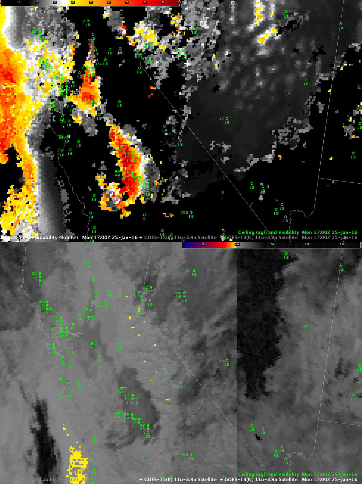
GOES_IFR_BTD_1700_25Jantoggle

As above, but at 1700 UTC (Click to enlarge)