Category Archives: Wisconsin

Late Spring in the Great Lakes: Fog

GreatLakes_2100_26May2015

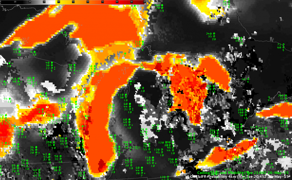
GOES-R IFR Probability fields, 2100 UTC on 26 May 2015, along with surface observations of ceilings and visibility (Click to enlarge)

Sea or lake surface temperatures are part of the algorithm used to create IFR Probability fields. The cold Great Lakes in late May are a prime location for advection fog, and IFR Probability fields will blanket the Great Lakes with high values under southerly, moist flow. It is not uncommon to see all of the Lakes bright orange/red. Note in the image above how Manitowoc WI and Charlevoix MI both have IFR Conditions. In addition, Dense Fog advisories were issued north of Milwaukee to the tip of Door County.

DenseFogAlongShore

Cloud Thickness as a Predictor of Fog Dissipation, part II

This post showed examples of Cloud Thickness and how its use as a predictor for dissipation time might be incorrect because of synoptic or mesoscale forcing.

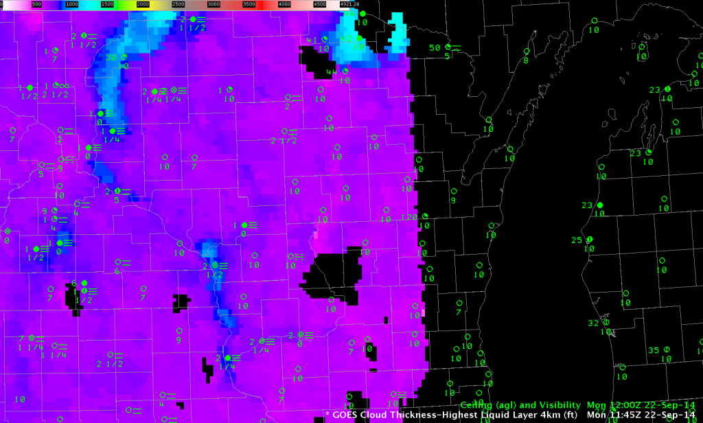
Radiation fog formed in River Valleys of Wisconsin early in the morning on 22 September, and the image below shows the final Cloud Thickness field computed before twilight conditions developed over western Wisconsin (twilight conditions are already occurring over eastern Wisconsin).

CloudThickness_1145UTC_22Sep2014

GOES-R Cloud Thickness (of the highest liquid water cloud layer) just before sunrise, 22 September 2014

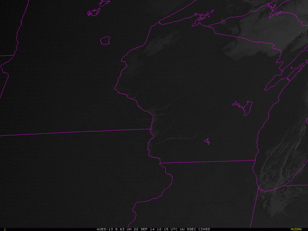
Cloud Thickness values near LaCrosse, WI, are around 900 feet; values are closer to 1200 feet over northeast Wisconsin along the St. Croix River. The chart suggests a dissipation time over the southwest part of Wisconsin of around 3 hours, and more than 4 hours over northwestern Wisconsin. The animation below shows that those estimates were accurate.

GOES13_VIS_22Sept_1215-1515

GOES-13 Visible (0.63 µm) Animation over Wisconsin, 22 September, 1215-1515 UTC (Click to animate)

Cloud Thickness as a Predictor of Fog Dissipation

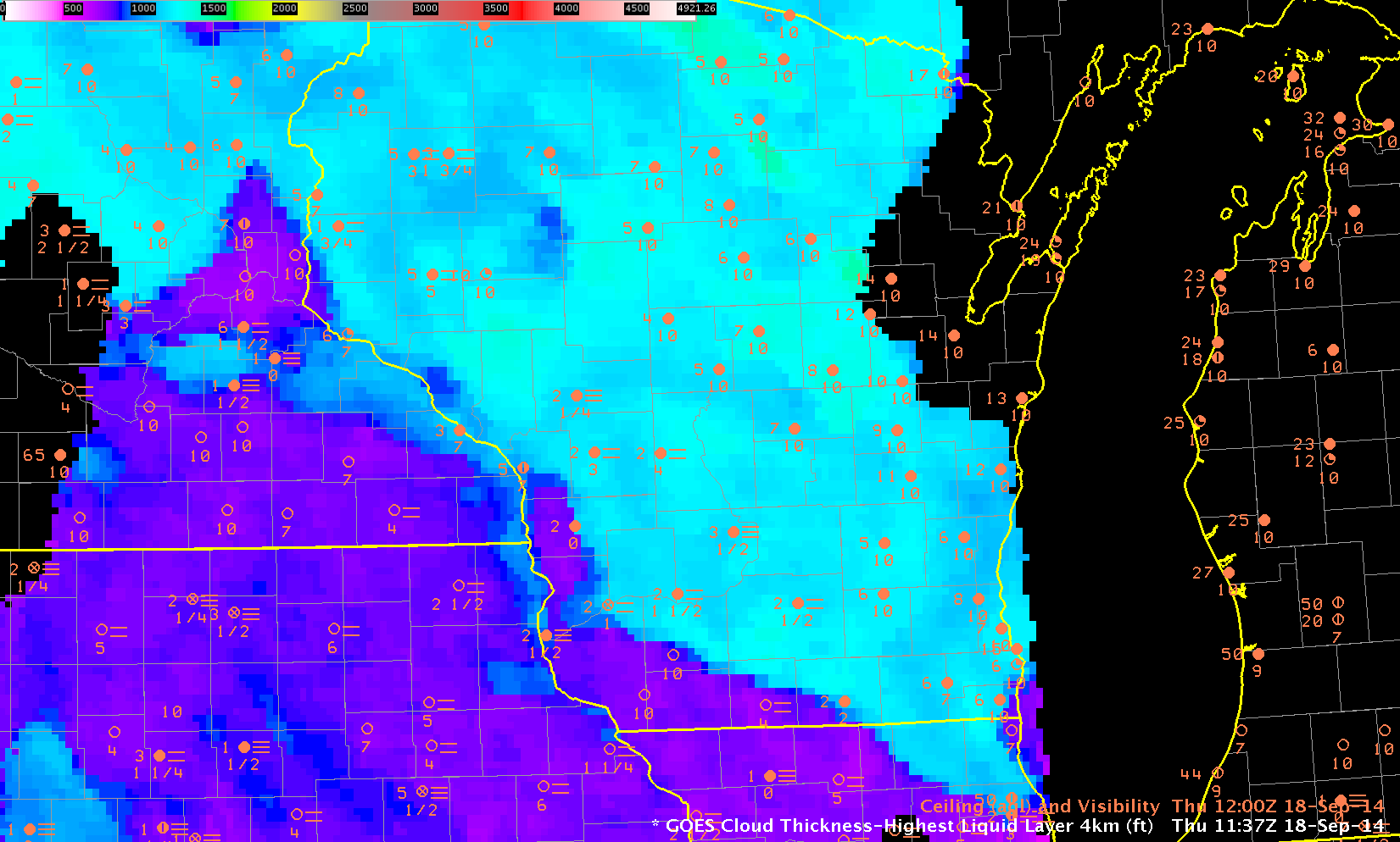
GOES_R_Cloud_Thickness_1137UTC_18Sep2014

GOES-R Cloud Thickness over Wisconsin and surrounding States, 18 September 2014, just before sunrise (Click to enlarge)

GOES-R Cloud Thickness can be used as a predictor for dissipation time of Radiation Fog, using this chart and the thickness (as above) from the last pre-dawn GOES-R Cloud Thickness field (Recall that GOES-R Cloud Thickness is not computed in the few hours of twilight surrounding sunrise or sunset; in the image above, twilight has reached lower Michigan but not yet Wisconsin). However, it’s important to remember that the chart is valid for radiation fog. Other forcings might cause fog to dissipate (or persist).

In the example above, Cloud Thickness values ranges from around 700 over southwest Wisconsin to as much as 1400 over north-central Wisconsin. Most of south-central Wisconsin (cyan) has values around 1200. According to the best-fit line, that suggests a burn-off time of more than 5 hours (although those values are extrapolated; note that no values that large went into the creation of the best-fit line) over WI, except over southwestern WI where a burn-off time of less than 1 hour is predicted. Did that work out?

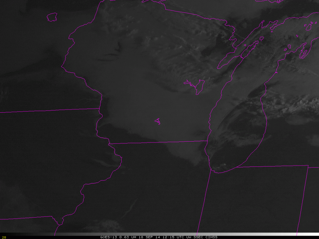
The animation below shows fog/low stratus moving towards the southwest with time. The cool and damp northeasterly flow from the Great Lakes into Wisconsin (surface map at 1800 UTC on 18 September) suppressed the heating necessary to reduce the relative humidity and foster fog evaporation. Perhaps the fog initially formed as advection fog; however, the northeasterly flow that developed early in the morning on 18 September came from a synoptic set-up that allowed fog to persist longer than the GOES-R Cloud Thickness algorithm suggests. This is not an uncommon occurrence. Clouds did not burn off over south-central WI until after 1800 UTC. During September, delayed burn-off of morning clouds can significantly affect the day-time temperature.
WIFOG_18Sep2014_12-20loop

Half-hourly visible imagery over Wisconsin, 1215-2045 UTC on 18 September (Click to animate)

=============================================================================

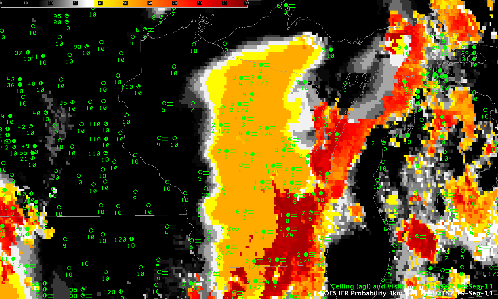
Low clouds and fog redeveloped during the morning of the 19th of September as well. This occurred during persistent southerly flow in advance of a low pressure system over the Northern Plains. The hourly animation of IFR Probabilities, below, shows IFR Probabilities developing over the course of the early morning of the 19th between 0315 and 1215 UTC. The animation shows a gradual overspreading of the IFR Probability field with higher clouds moving in from the west. (Here is a toggle between IFR Probability and GOES-13 Brightness Temperature Difference Fields at 1115 UTC; note how smooth the field is over much of WI where only Rapid Refresh model data can be used in the computation of the IFR Probability).
GOESR_IFRPROB_WI_19Sep2014_03-12

GOES-R IFR Probability fields, hourly from 0315-1215 UTC on 19 September (Click to animate)

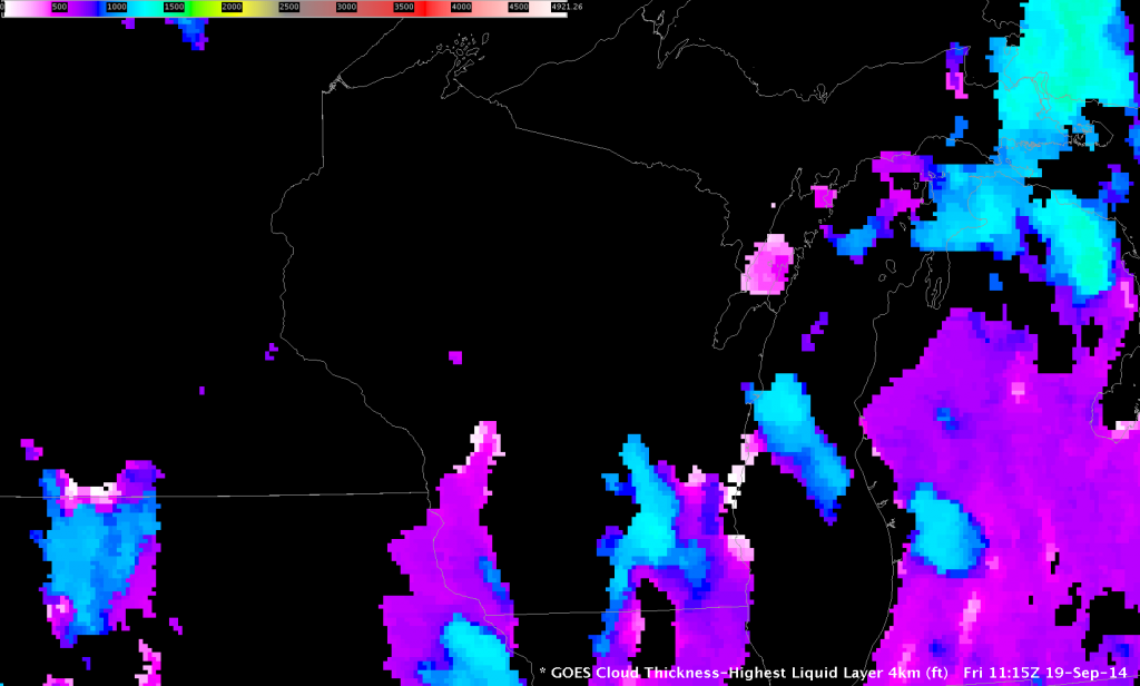
When high clouds overspread the scene, GOES-R Cloud Thickness is not computed. Thus, the last image before twilight, below, shows Cloud Thickness in only a few locations, but those values over southeast Wisconsin exceed 1200 feet, suggesting a burn-off of around 1615 UTC — 5 hours after this last Cloud Thickness image. In this case, that is an overestimate because the southerly winds over WI promote mixing, and the fog quickly dissipates after sunrise. It’s important to consider the synoptic forcing when you use Cloud Thickness. The last Cloud Thickness field and its use as a predictor for fog dissipation (using this chart) is most useful for radiation fog. The visible imagery animation at the bottom shows that the fog dissipated by 1415 UTC.
GOESR_CTH_WI_19Sept2014-9

GOES-R Cloud Thickness just before Sunrise (1115 UTC on 19 September 2015) (Click to enlarge)
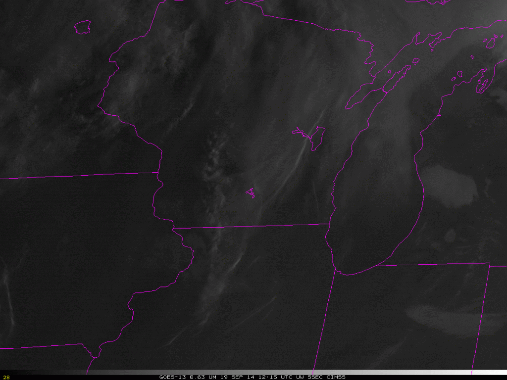
WIFOG_19Sep2014_12-16loop

GOES-13 Visible Imagery, 1215-1615 UTC on 19 September (Click to animate)
Advection fog over Lake Michigan

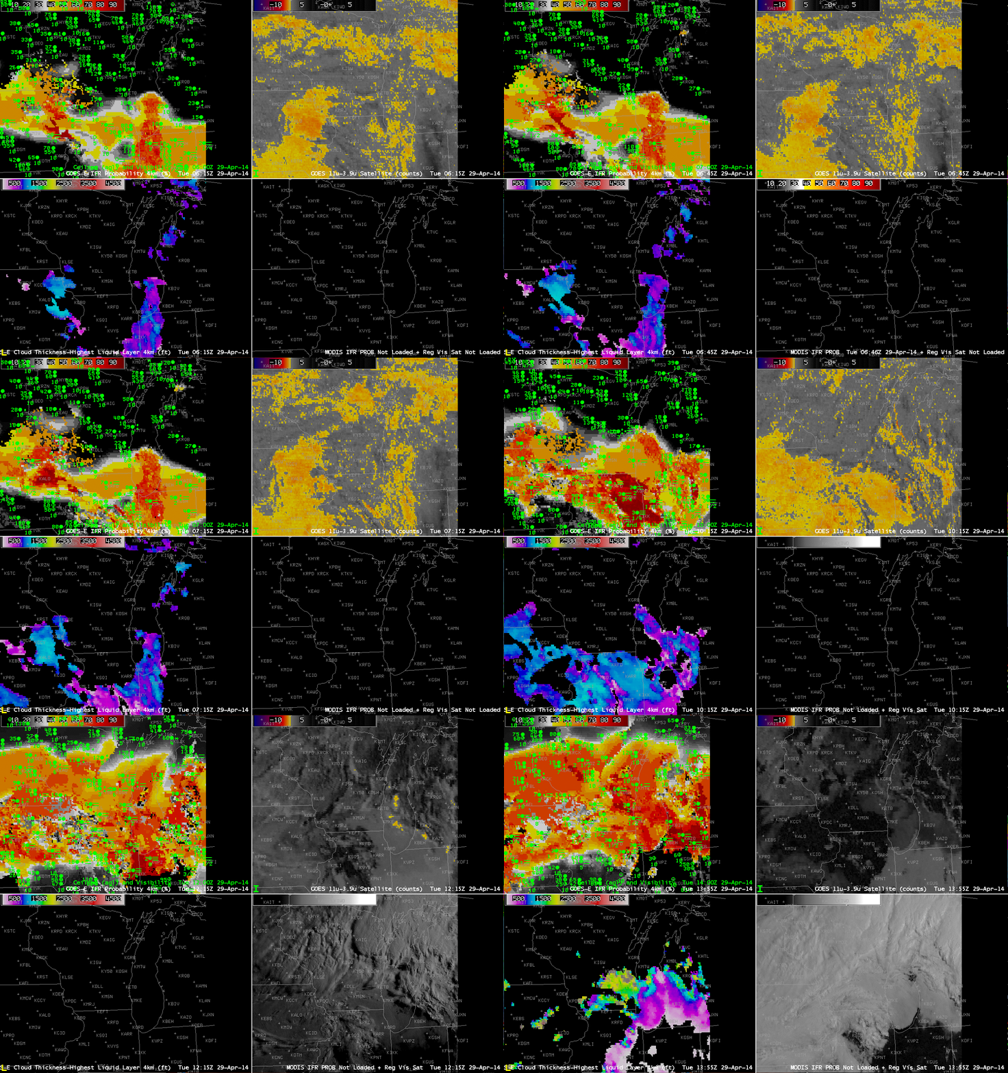
GOES_IFR_PROB_20140429loop

GOES-R IFR Probabilities computed from GOES-East (Upper Left), GOES-East Brightness Temperature Differences (10.7 µm – 3.9 µm) (Upper Right), GOES-R Cloud Thickness (Lower Left), GOES-R IFR Probabilities computed from MODIS, or GOES-East Visible Imagery, times as indicated on 29 April 2014 (click to enlarge)

The GOES-R IFR Probability fields computed from GOES-East captured the onset of Lake fog that moved onshore over eastern Wisconsin on April 29th. Multiple cloud layers associated with a strong extratropical cyclone precluded the use of the brightness temperature difference product (the heritage method of detecting fog/low stratus). However, the IFR Probability field aligns well with the reductions in visibility associated with the Lake fog. The character of the IFR Probability field can be used to infer whether of not satellite data predictors are being used. For example, the relatively flat field over southeast Wisconsin at the start of the animation is a region where satellite predictors are not used. The use of satellite predictors generally leads to a pixelated field. A flatter field as over southeast Wisconsin reflects the smoother model fields that are driving the probability field computation.

Cloud thickness is computed in regions where the highest cloud, as seen by the satellite, is a water-based cloud. And that is also usually the region where satellite predictors are used in the computation of IFR Probabilities. Note in the animation above how cloud thickness generally overlays regions of IFR Probability that are pixelated. Cloud thickness is not computed where only model data are used to compute IFR Probabilities. (Cloud thickness is also not computed in the hour or so around sunrise and sunset, during twilight conditions).

The slow northward movement of the fog bank is apparent in the first part of the animation above, from 0615 through 0745 UTC. Note also how the MODIS IFR Probability fields give a very similar solution to the GOES-13-based fields at 0745 UTC. Differences in resolution are apparent over southwest Wisconsin, however, where river valleys are more accurately captured by the MODIS fields.

In the visible imagery at the end of the animation (1355 UTC), the rapid saturation of moisture-laden air moving northward from Indiana over the cold waters of southern Lake Michigan is very apparent.

Fog and Stratus in one scene: What should be highlighted?

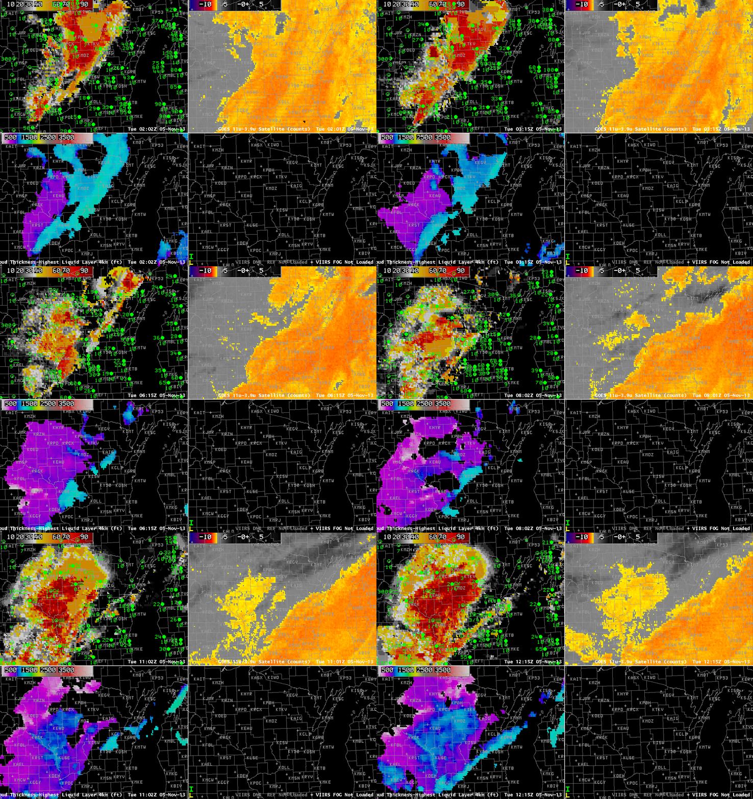
GOES_IFR_PROB_20131105loop

GOES-13-based GOES-R IFR Probabilities (Upper Left), GOES-13 Brightness Temperature Difference Product (10.7 µm – 3.9 µm) (Upper Right), GOES-R Cloud Thickness (Lower Left), Suomi-NPP Day/Night band (Lower Right), all times as indicated (click image to enlarge)

Dense fog developed over Western Wisconsin before sunrise on 5 November 2013. The animation above shows the development of high IFR probabilities in that region as a mid-level stratus deck shifts off to the east. Cloud thicknesses just before sunrise reach 1100 feet over portions of Wisconsin; according to this plot, fog should persist for at least 4 hours after sunrise. This was the case. Fog dissipated shortly after 1700 UTC.

This case shows a benefit of the GOES-R IFR Probability field: it accurately discerns the difference between low stratus/fog (that develops over western Wisconsin) and mid-level stratus (retreating to the east over central and eastern Wisconsin during the animation). Mid-level stratus is normally not a transportation concern whereas low clouds/fog most definitely are; in this case, dense fog advisories were issued by the Lacrosse, WI, WFO (ARX). At the beginning of the animation, widespread mid-level stratus is indicated (IFR conditions are not reported). As the night progresses, IFR Probabilities increase in regions where IFR conditions start to be reported. (A brightness temperature signal in GOES also develops in this region).

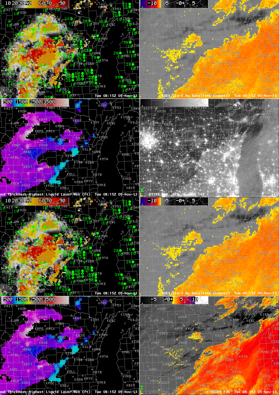
VIIRSDNB_FOG_20131105_0815

As above, but at 0815 UTC. The lower right image toggles between the Day/Night Band and the Brightness Temperature Difference (11.45 µm – 3.74 µm) from Suomi/NPP (click image to enlarge)

Suomi/NPP VIIRS viewed this scene shortly after 0815 UTC, and that imagery is above. Both the Day/Night band and the Brightness Temperature Difference fields (11.45 µm – 3.74 µm) are shown as a toggle. The mid-level stratus at 0815 is readily apparent. The developing fog over river valleys in western Wisconsin shows plainly in the brightness temperature difference field, but less so in the day/night band with scant lunar illumination.

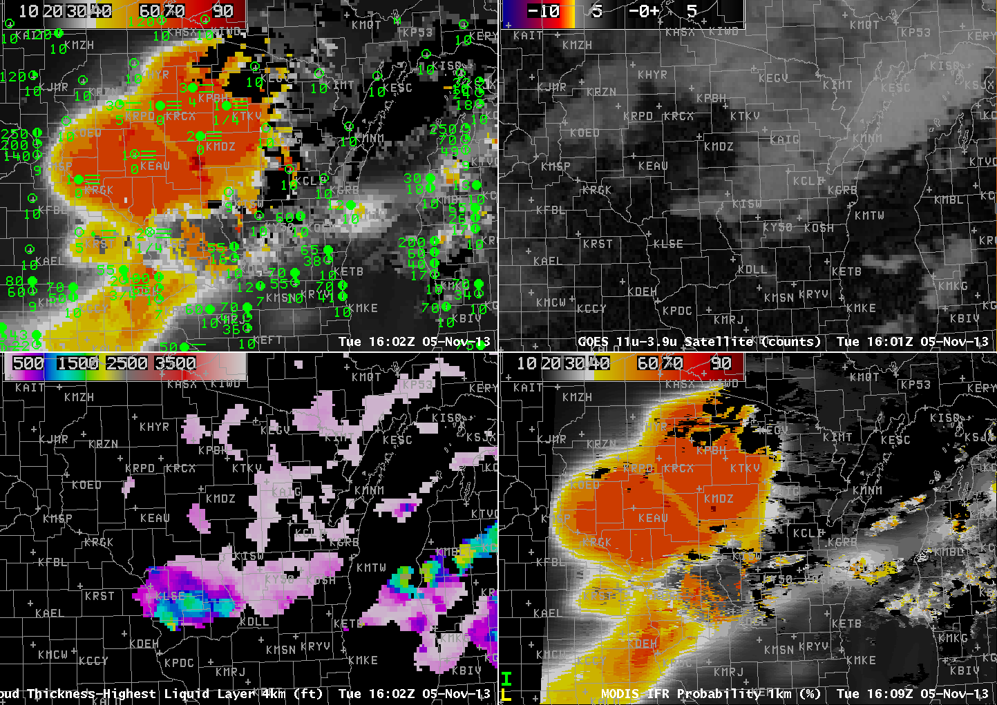
MODIS_IFR_PROB_20131105loop

GOES-13-based GOES-R IFR Probabilities (Upper Left), GOES-13 Brightness Temperature Difference Product (10.7 µm – 3.9 µm) (Upper Right), GOES-R Cloud Thickness (Lower Left), MODIS-based IFR Probabilities (Lower Right), all times as indicated (click image to animate)
MODIS data from Terra and Aqua is also used to produce IFR Probabilities, and those data are shown above, for three times: 0413 UTC, 0823 UTC and 1609 UTC. Patterns in the MODIS IFR Probability are similar to those in GOES, but small-scale features such as river valleys are much more apparent. Note that by 1609 UTC, higher clouds have overspread western Wisconsin in advance of an approaching mid-latitude cyclone; thus, the GOES and MODIS IFR Probabilities both are flat fields that are mostly based on Rapid Refresh data. Nevertheless, they both depict the region of IFR conditions over western Wisconsin that is surrounded by better visibilities and higher ceilings. Recall that GOES-R cloud thickness is not computed where high clouds are present.

Fog Development near Lake Michigan

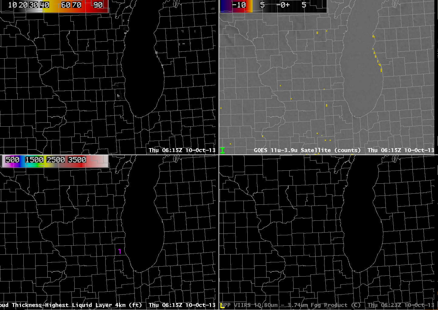
GOES_IFR_PROB_20131010_0615

GOES-13-based GOES-R IFR Probabilities (Upper Left), GOES-13 Brightness Temperature Difference Product (10.7 µm – 3.9 µm) (Upper Right), GOES-13-based GOES-R Cloud Thickness (Lower Left), Suomi/NPP Brightness Temperature Difference (Lower Right), all near 0615 UTC on 10 October (click image to enlarge)

The GOES-R IFR Probability product gave useful advance warning to the development of fog near Lake Michigan’s eastern shore overnight. The image above, from 0615 UTC, shows a flat brightness temperature difference field over the lakeshore counties in Wisconsin and Illinois (values are from -7.1 to -7.3); there are two regions of high values in the IFR Probability field, however: Near Manitowoc WI (values up to 29%) and over southeast WI and northeast IL (values near 20%). So by 0615 UTC on 10 October, IFR Probabilities are suggestive of a nascent fog development.

GOES_IFR_PROB_20131010_0702

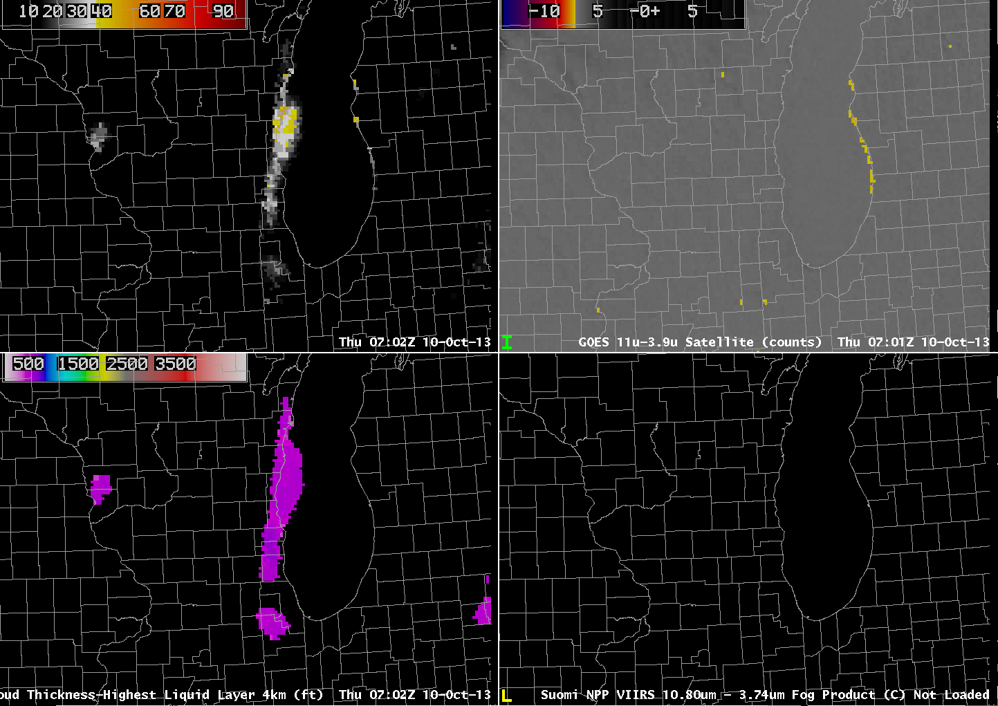
As above, but for 0702 UTC on 10 October (click image to enlarge)

Forty-five minutes later, at 0702 UTC (above), IFR Probabilities have increased dramatically in eastern WI even as the brightness temperature difference field remains flat. Thus, the Rapid Refresh Data is accurately capturing the development of low-level saturation in the atmosphere, and that is influencing the IFR probability field. In addition, the GOES-R Cloud Thickness field is suggesting that the cloud bank is 500-600 feet thick. The strip of enhanced brightness temperature difference paralleling the Lake Michigan shore in lower Michigan is an artifact of the co-registration error between the 10.7 µm and 3.9 µm band detectors on GOES-13. Between 0656 UTC and 0734 UTC, visibility at Manitowoc, WI (KMTW), dropped from 5 to 3/4 statute miles. The visibility at Burlington WI (KBUU) dropped from 4 to 1 statute miles between 0600 and 0700 UTC, and Waukegan, IL (KUGN) reported a visibility of 1/4 mile at 0552 UTC and 0652 UTC.

GOES_IFR_PROB_20131010_0802

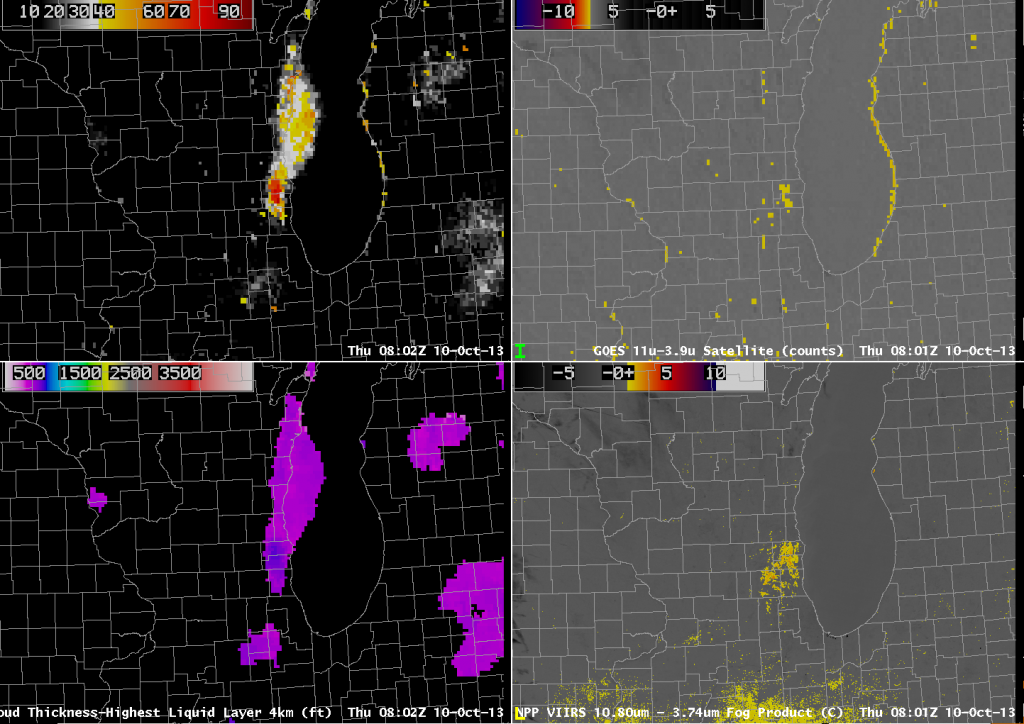
As above, but for 0802 UTC on 10 October (click image to enlarge)

At 0802 UTC, the GOES-East brightness temperature difference field shows greater differences over the region of SE Wisconsin where the fog is developing. Accordingly, the IFR probability increases past 80% IFR Probabilities are near 70% in Manitowoc County (and Manitowoc reported 1/2-mile visibility at 0834 UTC). Compare the GOES-East and Suomi/NPP Brightness Temperature Difference Fields; note the lack of a signal in the Suomi/NPP field along the western shore of Lake Michigan, confirming the co-registration error present in GOES-13.

GOES_IFR_PROB_20131010_1145

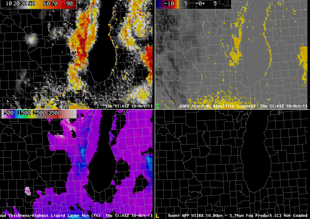
As above, but for 1145 UTC on 10 October (click image to enlarge)

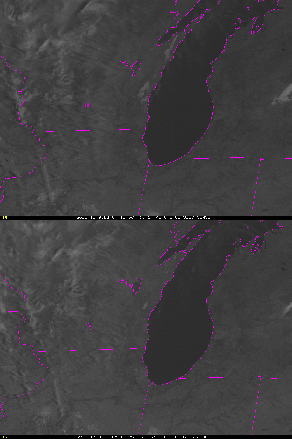
The last pre-sunrise image, 1145 UTC, shows a definite signal of fog/low stratus in both the IFR Probability field and in the Brightness Temperature Difference field. However, the early detection in the IFR Probability field gives a nice head’s up to the forecaster. Note also in this image how the strong signal in the brightness temperature difference field that arises because of the co-registration error can contaminate the IFR Probability field. The Cloud Thickness in this field has been related to dissipation time, as shown in this chart. The maximum thickness of 1000 feet predicts a dissipation time around 1500 UTC. The 1445 and 1515 UTC GOES-13 visible images are shown below.

GOES13_VIS_10Oct2013loop

GOES-13 Visible Imagery at 1445 UTC and 1515 UTC on 10 October (click image to enlarge)

1-minute Imagery of Fog Dissipation

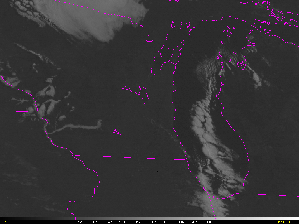
GOES-14 0.62 µm Visible images (click image to play animation)

GOES-14 0.62 µm Visible images (click image to play animation)

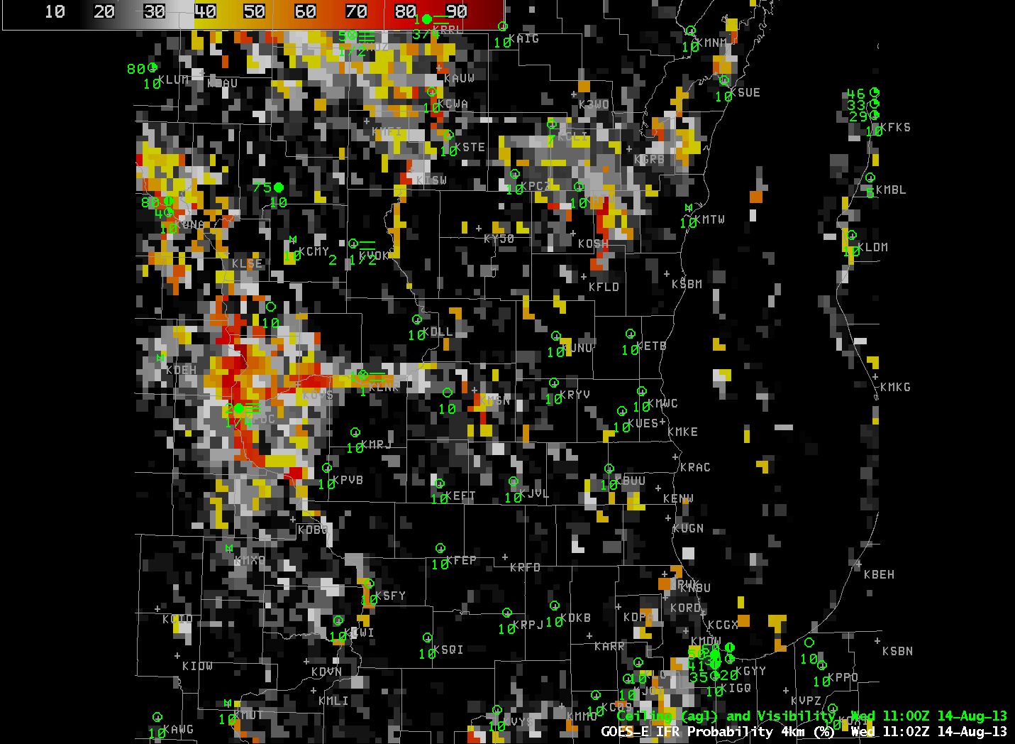
GOES-14 is in experimental SRSO-R mode for the next few weeks, and the 1-minute imagery it is yielding provides a close look at the dissipation of fog after sunrise. In this example, fog in the Wisconsin River Valley burns off. How did ‘conventional’ observations of the fog produced from GOES-13 and the Rapid Refresh Model observe this small region of fog? Hourly imagery of IFR Probabilities, below, show the development of highest probabilities along the Wisconsin River. This is a region where IFR conditions were observed around sunrise.

GOES_IFR_PROB_20130814loop

GOES-R IFR Probabilities (click image to play animation)

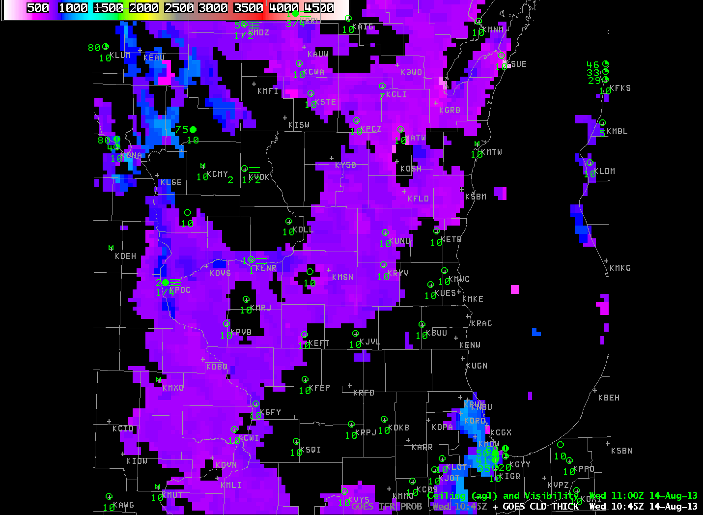
GOES-R Cloud Thickness, below, also shows a signal over the Wisconsin River, with maximum cloud thickness around 800 ft. According to this chart, a fog with a thickness of 800 feet should burn off in between 1 and 2.5 hours. The GOES-14 animation confirms this prediction. Fog dissipates shortly after 1400 UTC. Note that the GOES-R Cloud Thickness loop, below, terminates at 1102 UTC, the last image before twilight conditions necessitate that the product not be computed.

GOES_CLD_THICK_20130814loop

GOES-R Cloud Thickness (click image to play animation)

GOES-14 views of Valley Fog in West Virginia on this same day are available here.

Fog detection in the Upper Midwest

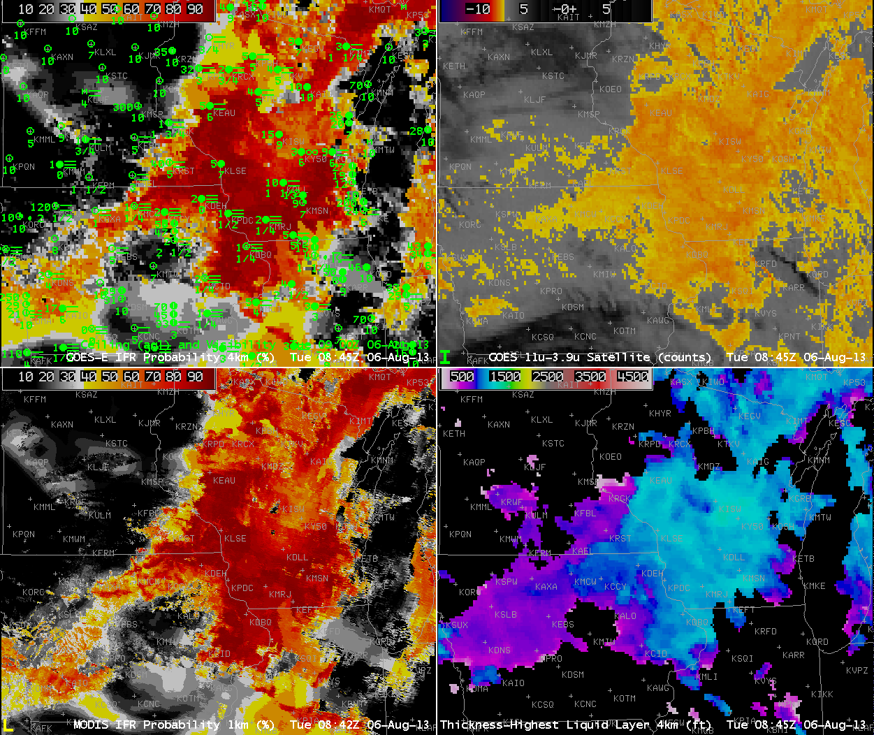
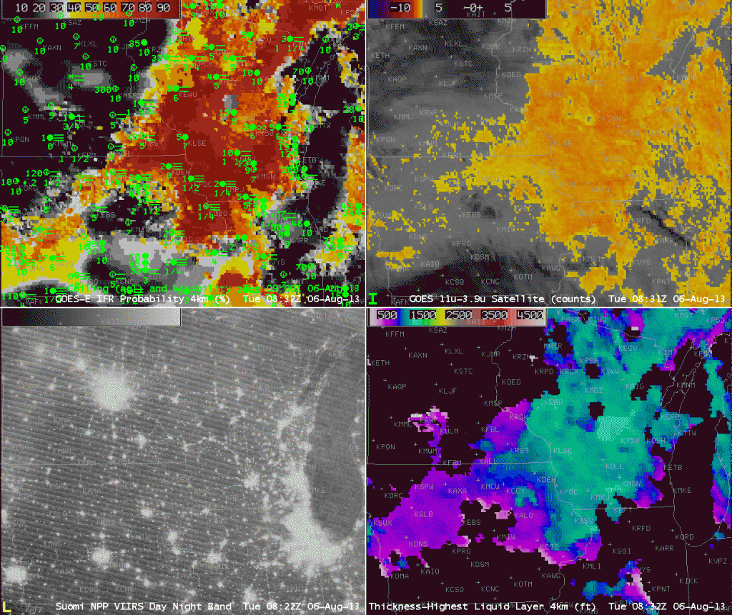
GOES-based GOES-R IFR Probabilities (Upper Left), GOES-East Brightness Temperature Difference (Upper Right, 10.7 µm - 3.9 µm), MODIS-based GOES-R IFR Probabilities (Lower Left), GOES-based GOES-R Cloud Thickness (Lower Right) (click image to play animation)

GOES-based GOES-R IFR Probabilities (Upper Left), GOES-East Brightness Temperature Difference (Upper Right, 10.7 µm – 3.9 µm), MODIS-based GOES-R IFR Probabilities (Lower Left), GOES-based GOES-R Cloud Thickness (Lower Right) (click image to play animation)

As nights lengthen in the upper Midwest in late Summer, the probability of fog development increases, especially on nights after light rainfall. The hourly animation, above, shows the gradual areal increase in high IFR probabilities that occurs as surface visibilities fall. Several aspects to the animation bear investigation. Note, for example, that at the start of the animation, the brightness temperature difference field, the traditional method used for fog detection, has a strong signal over eastern Illinois and western Indiana, a region where IFR conditions are not reported. This is a region of stratus clouds. Rapid Refresh model data that are incorporated into the GOES-R algorithm screens out these mid-level clouds; IFR probabilities in that region are correctly negligible. The end of the animation, 1215 UTC, occurs after sunrise, and reflected 3.9 µm solar radiation is affecting the brightness temperature difference field. The solar radiation complicates the use of the brightness temperature difference field as the sun rises. (Note also in that 1215 UTC image that GOES-R Cloud Thickness is not computed as it is during twilight conditions).

VIIRS_20130806toggle

The VIIRS instrument on board Suomi/NPP includes a day/night band that uses reflected Earth Glow and reflected lunar light to detect clouds. When the moon has set (or near times of the new moon — and the new moon occurs on August 6th, the date of these images), the scant illumination from Earthglow only makes low cloud detection a challenge. The brightness temperature difference product will still detect water-based cloudiness, however, as shown in the toggle above. However, the brightness temperature difference product does not include information on the cloud base, only on the cloud top. Incorporation of Suomi/NPP data into the GOES-R IFR Probability algorithm is ongoing.

Resolution and Cloud Depth

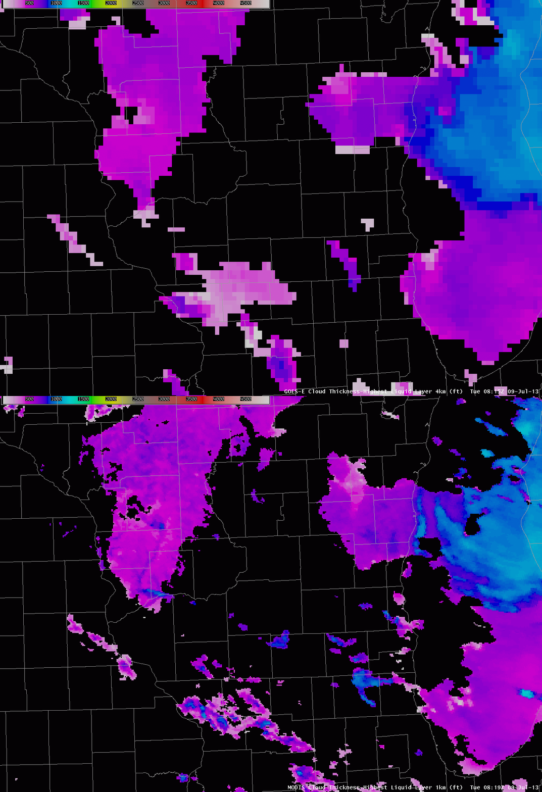
GOES-R Cloud Thickness computed from GOES-East and from MODIS data, ~0815 UTC 9 July 2013

The resolution and view angle of MODIS, compared to the GOES Imager, means that smaller features are better resolved and more accurately navigated.  In the example above, the Kickapoo River in Vernon, Richland and Crawford Counties in southwest Wisconsin is clearly delineated in the MODIS product, with a small ribbon of values from 800-1000 feet, but not in the GOES where values are closer to 600.  Differences along the coast of Lake Michigan are also evident.  MODIS detects a thick cloud bank off the coast of Sheboygan County (the cloud thickness is near 1000 feet);  GOES detection has thicknesses of 800 feet in that region, but the values are shifted onshore because of parallax and the co-registration error that exists between the 10.7 µm and 3.9 µm  channels on the GOES-13 Imager.

If you are using Cloud Thickness to estimate fog dissipation, the difference between 1000 and 800 feet equates to 60-90 minutes.

Lake Michigan Fog

Fog from Lake Michigan is a year-round hazard for travel in eastern Wisconsin.  One of the biggest crashes on an interstate in Wisconsin occurred in October 2002 on I-43 near Sheboygan as fog moved onshore.  Ten died in that event that included 25 vehicles.

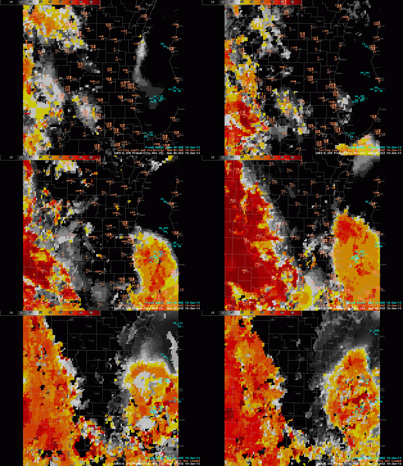
Rain overnight followed by partial clearing led to widespread fog over the upper Midwest on June 10, 2013, and the IFR Probability products described the horizontal extent of the lowest visibilities.  Those low visibilities hugged the coast of Lake Michigan in eastern Wisconsin.

GOES-R IFR Probabilities, 0402 – 1345 UTC on 10 June 2013, computed from GOES-East

GOES-R IFR probabilities increase in two regions overnight:  over Iowa and in the western Wisconsin River Valleys, and over Lake Michigan.  Reduced visibilities are reported in and around Lake Michigan, and as the tweet up top shows, dense fog was reported along highways as well.  Water temperatures in the upper 40s over central Lake Michigan promote the development of fog, as dewpoints over Wisconsin were near 60.

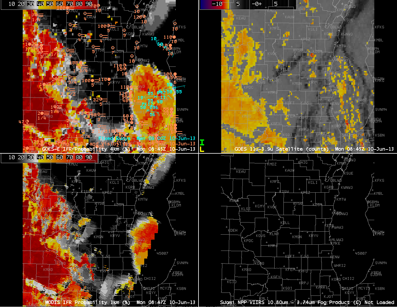
GOES-R IFR Probabilities computed from GOES-East (Upper Left) and from MODIS (Lower Left);  GOES-East Brightness Temperature Difference Product (Upper Right), all from approximately 0845 UTC on 10 June 2013

The GOES Imager usually cannot resolve small river valleys.  Polar-orbiting data, however, usually can.  The MODIS-based IFR probability from 0847 UTC better resolves the Wisconsin River Valley over southwest Wisconsin, for example.