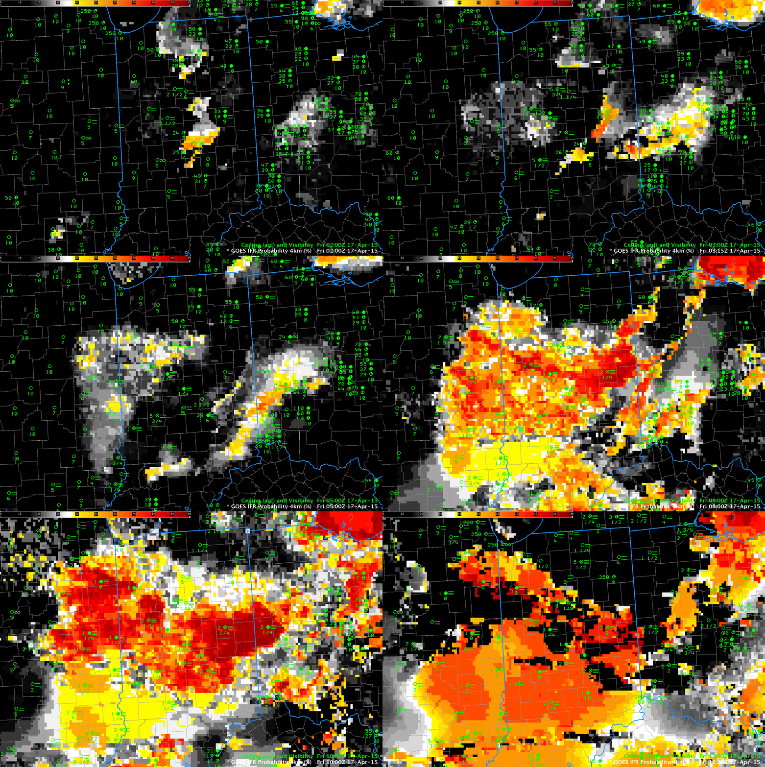
GOES-R IFR Probabilities over Indiana and surrounding states, 0200-1215 UTC on 17 April (Click to enlarge)
For developed over Indiana and surrounding states during the morning of April 17th. An hourly animation of GOES-R IFR Probabilities, from 0200 through 1215 UTC, computed from GOES-East and Rapid Refresh Data is shown above. Fog is developing at 0200 UTC, already over portions of western Indiana, and IFR Probabilities increase quickly. By 0700 UTC, large regions show reduced visibilities and IFR Probabilities exceeding 85%.
High clouds moving in from the west and southwest starting at about 0800 UTC have an impact on the IFR Probability fields as well. Only Rapid Refresh Data are used to compute IFR Probabilities where mid-level and high clouds prevent satellite detection of low clouds. As a result, the character of the field changes: it becomes flatter (less pixelated) and values decrease (because probability is not so certain when satellite data cannot be used to validate Model predictions).
The final image in the animation above, at 1215 UTC, was computed just after sunrise. Note that IFR Probability values generally increase. This is especially notable in regions where mid-level and high-level clouds are present (over southern Illinois and southern Indiana). Probabilities are higher because the satellite can detect clouds are present. There are also regions at 1215 UTC where IFR Probabilities rapidly drops to zero. This is likely a difficulty in the Cloud Typing algorithm that occurs with very low sun angle (as discussed here). Holes at 1215 UTC have filled in by 1300 UTC.
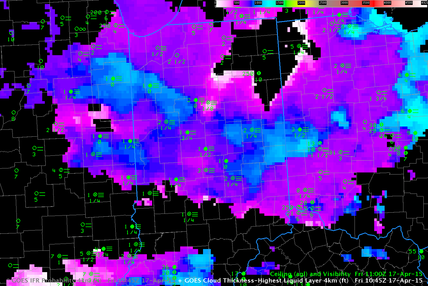
Cloud thickness can give a first estimate of cloud dissipation time. This link shows a scatterplot with a best-fit line that relates dissipation time to Cloud Thickness from a past study. The Cloud Thickness used is the final one computed before twilight conditions, and that is shown below. (Note that cloud thickness is not computed in regions where mid-level and high-level clouds exist) Much of the fog over Indiana is relatively thin — less than 800 feet thick — with a few regions that exceed 1000 feet. Burn-off of this fog should be relatively quick, and most of the Dense Fog Advisories expired at 1400 UTC.
URGENT - WEATHER MESSAGE
NATIONAL WEATHER SERVICE NORTHERN INDIANA
600 AM EDT FRI APR 17 2015

INZ020-022-023-032>034-171400-
/O.NEW.KIWX.FG.Y.0005.150417T1000Z-150417T1400Z/
WHITE-CASS IN-MIAMI-GRANT-BLACKFORD-JAY-
INCLUDING THE CITIES OF...MONTICELLO...BROOKSTON...MONON...
LOGANSPORT...ROYAL CENTER...PERU...GRISSOM AFB...MEXICO...
MARION...GAS CITY...UPLAND...HARTFORD CITY...MONTPELIER...
PORTLAND...DUNKIRK
600 AM EDT FRI APR 17 2015

...DENSE FOG ADVISORY IN EFFECT UNTIL 10 AM EDT THIS MORNING...

THE NATIONAL WEATHER SERVICE IN NORTHERN INDIANA HAS ISSUED A
DENSE FOG ADVISORY...WHICH IS IN EFFECT UNTIL 10 AM EDT THIS
MORNING.

* VISIBILITY: A QUARTER MILE OR LESS.

* IMPACTS: VERY HAZARDOUS DRIVING CONDITIONS...WHICH WILL LEAD TO
  TRAVEL DELAYS. PLEASE LEAVE EARLY IF TRAVELING THIS MORNING AND
  ALLOW EXTRA TIME TO REACH YOUR DESTINATION.

PRECAUTIONARY/PREPAREDNESS ACTIONS...

A DENSE FOG ADVISORY MEANS VISIBILITIES WILL FREQUENTLY BE
REDUCED TO LESS THAN ONE QUARTER MILE. IF DRIVING...SLOW DOWN...
USE YOUR HEADLIGHTS...AND LEAVE PLENTY OF DISTANCE AHEAD OF YOU.

