Dense fog devloped over South Carolina overnight, in an event that was well-anticipated: From the Charleston, SC, National Weather Service Office AFD (emphasis added):
AREA FORECAST DISCUSSION
NATIONAL WEATHER SERVICE CHARLESTON SC
648 PM EST TUE DEC 2 2014
.SYNOPSIS…
WEAK HIGH PRESSURE WILL PERSIST THROUGH WEDNESDAY. A COLD FRONT
WILL ADVANCE SOUTH THROUGH THE AREA THURSDAY…THEN HIGH PRESSURE
WILL BUILD FROM THE NORTH AND WILL PREVAIL THROUGH FRIDAY. LOW
PRESSURE WILL TRACK THROUGH OR JUST NORTH OF THE REGION SATURDAY…
FOLLOWED BY COLD FRONTS SATURDAY NIGHT AND AGAIN LATE MONDAY.
&&
.NEAR TERM /UNTIL 6 AM WEDNESDAY MORNING/…
A FEW LINGERING STRAY SHOWERS WEST OF I-95 WILL DISSIPATE THIS
EVENING WITH THE ONSET OF NOCTURNAL COOLING AND STABILIZATION.
OUR MAIN FOCUS FOR TONIGHT IS IN REGARDS TO FOG AND THE BUILD DOWN
OF STRATUS…SOME OF WHICH COULD BE DENSE. THE HIGH PRESSURE WEDGE
WILL REMAIN ANCHORED OVER THE INLAND PARTS OF THE SE AS IT
PROGRESSES A LITTLE SOUTHWARD THROUGH THE NIGHT…WITH A WEAK
COASTAL TROUGH OFFSHORE. A STRENGTHENING NOCTURNAL INVERSION WILL
DEVELOP AND TRAP ABUNDANT MOISTURE WITHIN THE PLANETARY BOUNDARY
LAYER UNDERNEATH. THIS WILL LEAD TO THE DEVELOPMENT AND SPREADING
OUT OF FOG AND STRATUS ENCOMPASSING MOST IF NOT ALL OF THE CWFA
DURING THE LATE NIGHT HOURS. BUT ALREADY WE/RE SEEING A FOG BANK
WITH IT/S ORIGINS NORTH OF THE SANTEE RIVER THIS AFTERNOON IS
PROGRESSING SOUTH/SW AND STARTING TO SPREAD A LITTLE INLAND. THIS
IS CLEARLY DEPICTED BY THE 11-3.9 MICRON SATELLITE IMAGERY AS WELL
AS COASTAL METAR SITES. THE COMBINATION OF THE MARINE INDUCED FOG
AND STRATUS WILL COMBINE WITH RADIATION FOG THAT FORMS OVER INLAND
SECTIONS TO RESULT IN AREAS OF FOG ACROSS THE FORECAST ZONES. THE
WORST CONDITIONS WILL BE OVER CHARLESTON COUNTY THIS
EVENING…SPREADING INTO OTHER COASTAL SC ZONES LATER THIS EVENING
AND INTO THE GA COASTAL ZONES BY MIDNIGHT OR SO. INLAND THE BULK
OF THE GREATER FOG/STRATUS COVERAGE WILL WAIT UNTIL WE REACH OUR
CROSS-OVER TEMPS BY 2-3 AM. DENSE FOG ADVISORIES ARE CERTAINLY
POSSIBLE. ANY NEGATING FACTORS AGAINST THE WIDESPREAD DENSE FOG
WOULD BE THE RELATIVELY WARM GROUNDS. BUT GIVEN FOG STABILITY
INDICES IN THE TEENS AND LOWER 20S…MOST PLACES REACHING THEIR
CROSS-OVER TEMPS OF 55-60 AND SOME MARINE FOG WE/D LEAN MORE
TOWARD DENSE FOG BECOMING A CONCERN…THAN NOT.

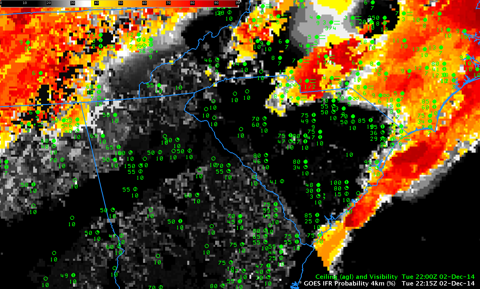
GOES-based GOES-R IFR Probabilities, hourly from 2215 UTC 2 December through 1315 UTC on 3 December as well as observations of ceilings (AGL) and visibilities (Click to enlarge)
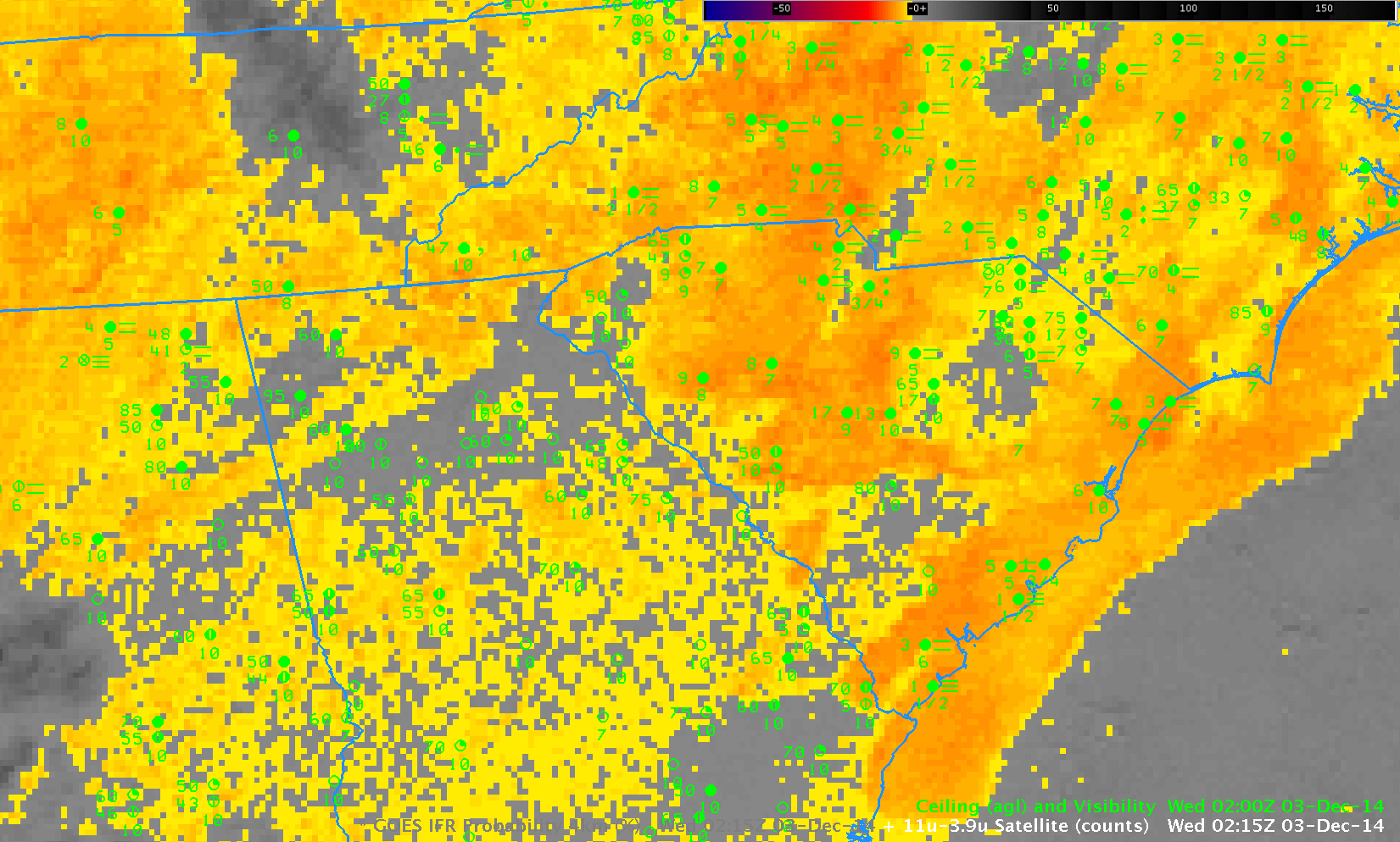
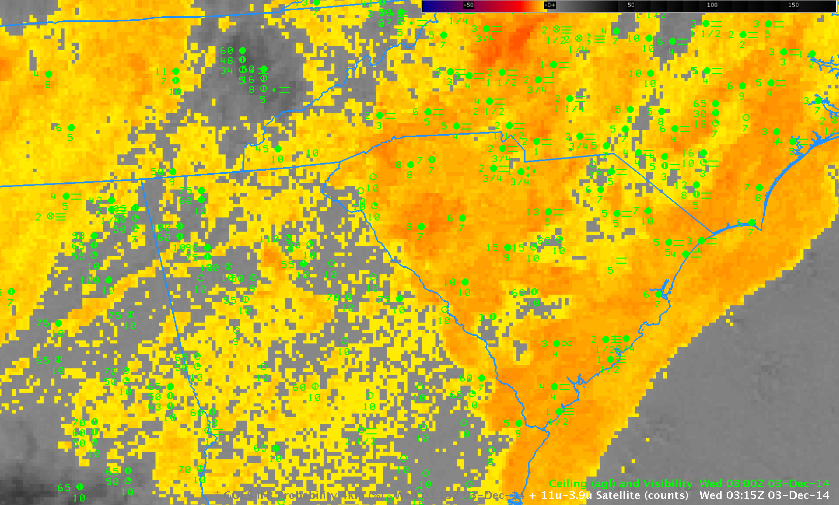
The GOES-R IFR Probability fields, shown at hourly intervals above, nicely capture the spread of the extensive fog as the expanding marine fog bank joins up with the developing radiation fog over northwestern South Carolina. (A loop with a shorter dwell rate is here). GOES-13 Brightness Temperature Difference Fields are shown below. (A loop with a shorter dwell rate is here). Brightness Temperature Difference is the traditional method of detecting fog and low stratus, and it is referenced in the AFD above. However, the method cannot operate in regions with high cirrus (such as over Tennessee and northwest South Carolina after 0900 UTC); the brightness temperature difference signal flips sign as the sun rises (as at 1315 UTC in the animation below); the method cannot distinguish between elevated stratus and visibility-restricting fog.
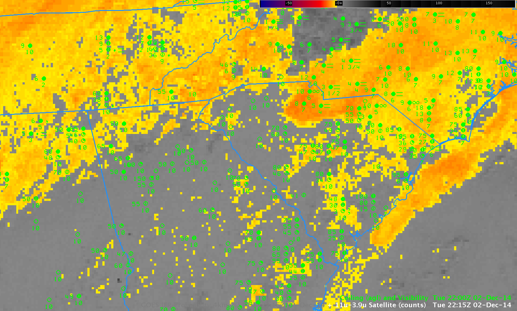
GOES-13 Brightness Temperature Difference Fields (10.7µm – 3.9µm), hourly from 2215 UTC 2 December through 1315 UTC on 3 December, as well as observations of ceilings (AGL) and visibilities (Click to enlarge)
In comparing the two animations, note how the Brightness Temperature Difference field, for example, has strong returns around 0215-0315 UTC over central South Carolina in regions where widespread IFR conditions do not yet exist. In these regions, the Rapid Refresh model data used as a predictor in the GOES-R IFR Probability is not yet showing saturation, so IFR Probabilities aren’t quite so high as they are along the coast. (Click here for a toggle between the GOES-R IFR Probability and the Brightness Temperature Difference fields at 0215 UTC; a toggle at 0315 UTC is here). Note also in the toggles how the IFR Probability fields have little signal over Georgia despite the Brightness Temperature Difference field signal. This demonstrates the power of using fused data products: both the satellite and the model signal must be in accord for very high probabilities to occur.