Monthly Archives: May 2014

Terrain and IFR Probabilities

GOES_IFR_PROB_20140528_0930_terrain

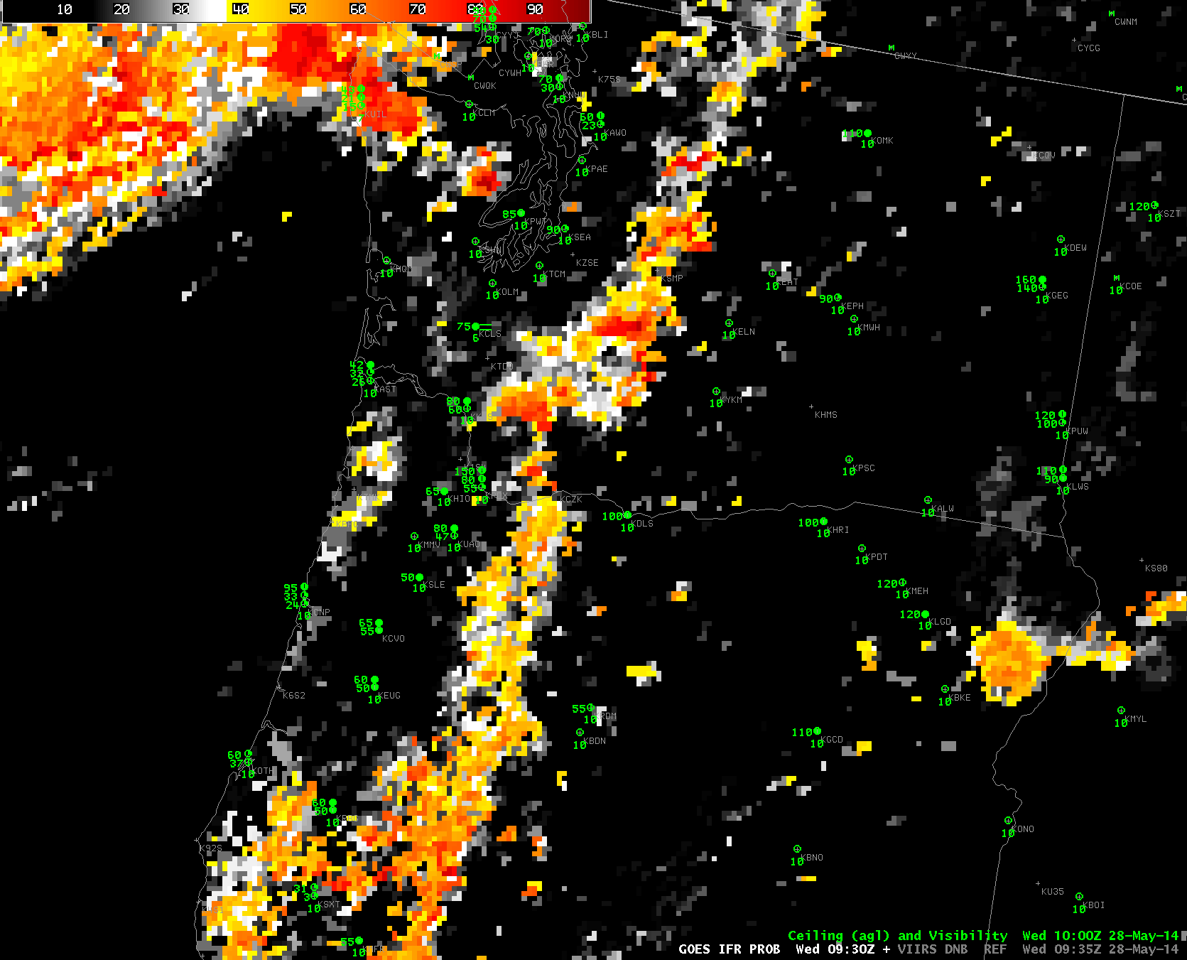
GOES-R IFR Probabilities computed from GOES-West at 0930 UTC on 28 May, and Color-enhanced terrain (Click image to enlarge)

When IFR Probabilities are enhanced over high terrain, how confident can you be that IFR conditions are occurring? Surface observations are rare on mountain tops. It’s possible that clouds occurring are at one level as the terrain rises up into the clouds, and ceilings at adjacent stations can give an indication of the cloud base (in the present case, ceilings are about 9000 feet above sea level at Seattle, for example).

Suomi/NPP Day/Night band imagery can verify that clouds exist in the region where IFR Probabilities are elevated. The toggle below, of Day/Night band and Brightness Temperature Differences, shows compelling evidence (even in low light conditions) of clouds along the spine of the mountains in central Washington and Oregon.

VIIRS_DNB_FOG_20140528_0935

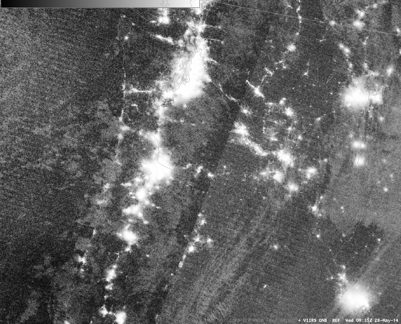
Suomi/NPP VIIRS Day/Night Band and Brightness Temperature Difference (11.45 µm – 3.74 µm), 0935 UTC on 28 May (Click to enlarge)

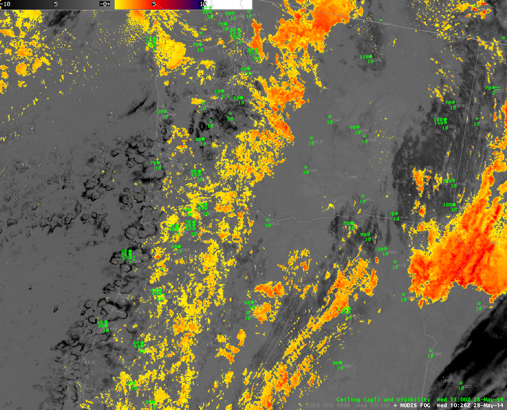
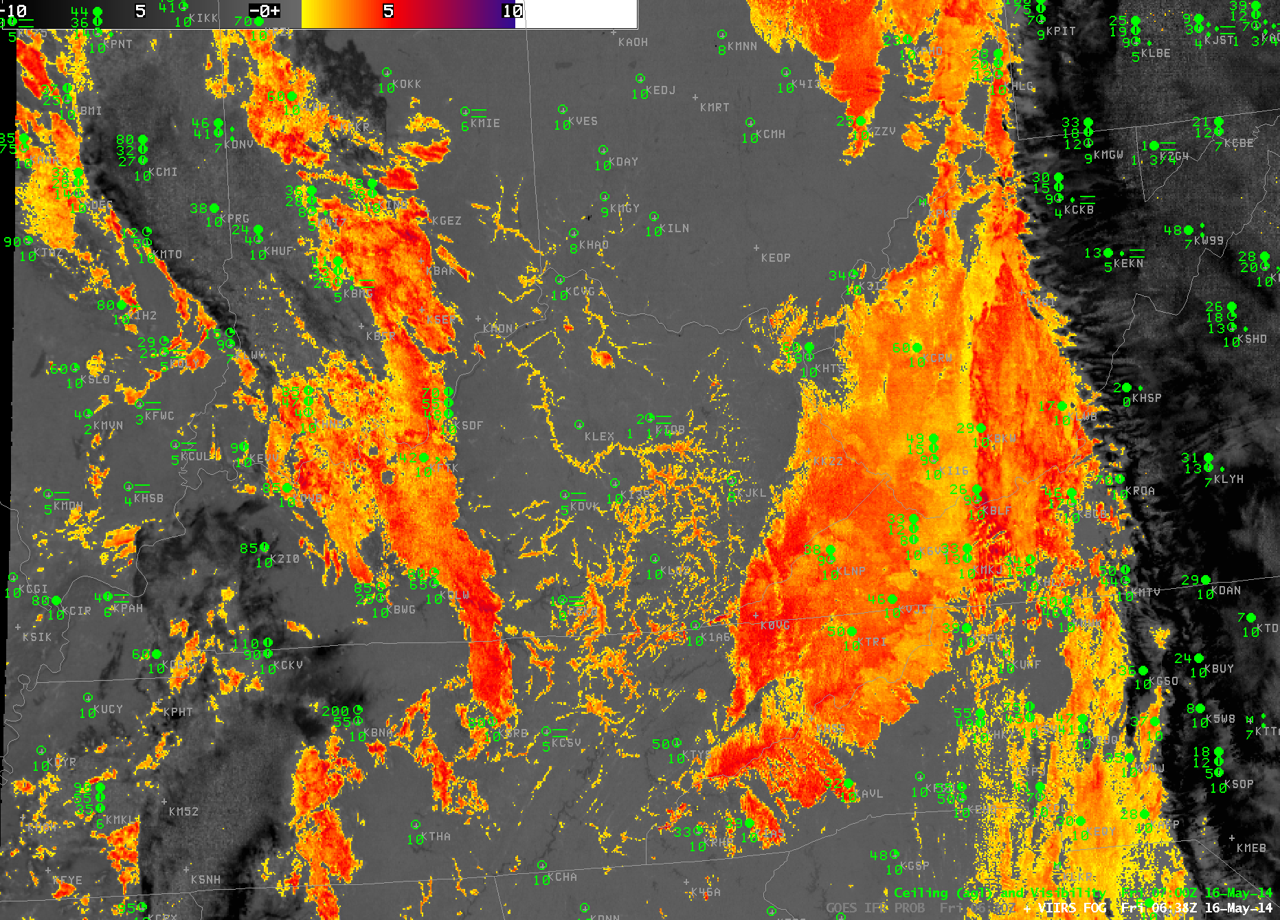
High-resolution MODIS data are also used to produce IFR Probabilities, and they can be used to deduce the presence of low ceilings/reduced visibilities as well. The toggle below, from 1027 UTC, shows the brightness temperature difference field (11.0 – 3.9) from MODIS and the IFR Probability field. It is likely in this case that high clouds were shrouding the higher peaks of the Cascade Mountains.

MODIS_FOR_IFR_PROB_20140528_1027

Benefits of Resolution with a Polar-orbiting satellite

US_11-3_GOES_IFR_201401516_0630toggle

Toggle between GOES-13 Brightness Temperature Difference (10.7µm – 3.9µm) and GOES-R IFR Probability over Kentucky and surrounding states. Surface observations of ceiling heights and visibility are included, 0630 UTC 16 May 2014 (Click to enlarge)

The toggle above highlights a strength of the GOES-R IFR Probability fields compared to the GOES Brightness Temperature Difference when it comes to detecting low fog/stratus. The Brightness Temperature Difference field only sees the top of the cloud. In the toggle above, the region of elevated stratus, the stratus over western Virginia and western West Virginia is highlighted, but those clouds are unimportant for aviation/transportation, and IFR Probability fields ignore that region (save for the spine of the Appalachians where the mountains are rising up into the clouds, so ceilings are near the surface).

There are heightened IFR Probabilities in/around KEKQ (Monticello, Kentucky) at 0630 UTC: what is the character of that fog? It’s difficult to tell with the coarse GOES resolution (although someone familiar with the topography of eastern Kentucky might guess).

The imagery below toggle between the high-resolution (1-km) Suomi/NPP VIIRS Brightness Temperature Difference (11µm – 3.74µm) and the Day/Night Band at 0638 UTC. The higher resolution imagery allows the dendritic nature of the valley fog to appear in a way that is impossible with the coarser-resolution GOES data. Fog is initially developing in river valleys. Both the Brightness Temperature Difference and Day/Night imagery, however, are seeing only the top of the cloud and are not giving information about the likelihood of fog. But the cloud structure would alert a forecaster to the probability of developing fog (as does the time trend in the GOES-R IFR Probability fields).

Note how the cirrus shield east of the Appalachians shows up distinctly in both GOES and VIIRS brightness temperature difference fields. High clouds such as those prevent the satellite detection of fog/stratus at low levels. In those cases, only the IFR Probability field has a chance to detect fog if it is present.

VIIRS_DNB_FOG_20140516_0638toggle

Suomi/NPP Brightness Temperature Difference (11.0µm – 3.74µm) and Day/Night Band from VIIRS, 0638 UTC 16 MAy 2014 (Click to enlarge)

By 1000 UTC, the fog that was initially confined to river valleys over central Kentucky has expanded. In this case, Suomi/NPP data (or the trending of the GOES data) gives a forecaster a heads up on the development of overnight fog.

GOES_IFR_PROB_20140516_1000

GOES-R IFR Probability over Kentucky and surrounding states. Surface observations of ceiling heights and visibility are included, 1000 UTC 16 May 2014 (Click to enlarge)

Radiation fog over coastal North Carolina

GOES_IFR_PROB_20140512_1000

GOES-R IFR Probabilities with observations of ceilings/visibilities (Upper Left), GOES-East Brightness Temperature Difference (10.7µm – 3.9µm) (Upper Right), GOES-R Cloud Thickness (Lower Left), Suomi/NPP VIIRS Day/Night Band (0.70 µm, at night) or GOES-East Visible imagery (0.63 µm, during day), Times as indicated (Click to enlarge)

Clear skies allowed for radiation fog with IFR conditions to develop over eastern North Carolina overnight. GOES-R Cloud Thickness as observed at the last time before twilight conditions begin — in this case at 1000 UTC (6 AM EDT) — can be used as a predictor for fog dissipation time using this chart. At 1000 UTC, maximum cloud thickness was 1000 feet, which suggests a dissipation time around 1300-1330 UTC.

The visible animation, below, is in agreement with the prediction from the cloud thickness field.

GOES13_VIS_NC_loop_12MAY2014

GOES-East Visible Imagery (0.62 µm) Times as indicated (Click to enlarge)

A toggle of two images with Day/Night band imagery, below, shows the difficulty in using the Day/Night band to identify regions of fog/low clouds consistently. In the 0615 UTC image, the developing low clouds show up well (Of course, it’s hard to tell if the clouds are low stratus or mid-level stratus), but the picture at 0745 UTC is a lot less distinct.

GOES_IFR_PROB_20140512_toggle_0615_0745

GOES-R IFR Probabilities with observations of ceilings/visibilities (Upper Left), GOES-East Brightness Temperature Difference (10.7µm – 3.9µm) (Upper Right), GOES-R Cloud Thickness (Lower Left), Suomi/NPP VIIRS Day/Night Band (0.70 µm), Times as indicated (Click to enlarge)

A toggle of two images with Day/Night band imagery, below, shows the difficulty in using the Day/Night band to identify regions of fog/low clouds consistently. In the 0615 UTC image, the developing low clouds show up well (Of course, it’s hard to tell if the clouds are low stratus or mid-level stratus), but the picture at 0745 UTC is a lot less distinct.

Radiation Fog in the Florida Panhandle

GOES_IFR_PROB_20140505loop

GOES-R IFR Probabilities computed from GOES-East (Upper Left), GOES-East Brightness Temperature Difference (10.7 µm – 3.9 µm) (Upper right), GOES-R Cloud Thickness (Lower Left), GOES-13 Heritage Cloud Thickness Product (Lower Right), times as indicated (Click to enlarge)

Clear skies and light winds over the Florida Panhandle allowed radiation fog to develop, and the GOES-R IFR Probability field ably captured the region of IFR conditions, as shown above. Note how the GOES-R Fields provide information that looks less ‘noisy’: the heritage products — Brightness Temperature Difference and Cloud Thickness — both have signals over interior Alabama and Mississippi where IFR conditions were not reported. In addition, the well-known co-registration error in the 10.7 and 3.9 sensors produces a faulty signal along the Florida coast east of Appalachee Bay. Eventually this signal because so strong that it bleeds into the GOES-R IFR probability.

Cloud thickness can be used to forecast fog dissipation time, using this chart and tempered by experience. The last pre-sunrise cloud thickness is shown at 1045 UTC in the loop above, and is around 1000 feet, suggesting a dissipation time around 1345 UTC. The visible animation below corroborates this estimate.

GOES13_FL_FOG_5MAY2014loop

GOES-R Visible (0.63 µm), times as indicated (Click to enlarge)