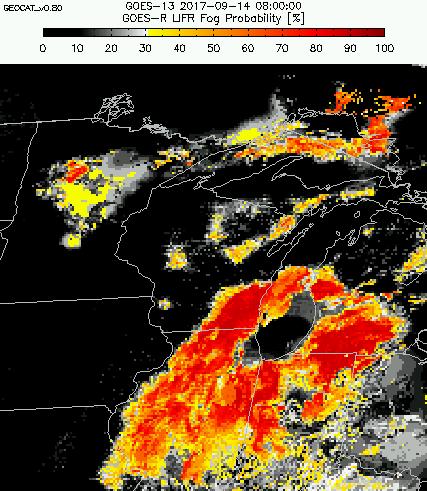
GOES-R IFR Probabilities are computed using Legacy GOES (GOES-13 and GOES-15) and Rapid Refresh model information; GOES-16 data will be incorporated into the IFR Probability algorithm in late 2017
GOES-R IFR Probability fields (From this site, but also available via LDM feed in AWIPS), above, show the development of dense for over Lower Michigan, leading to the issuance of advisories. IFR Probabilities on this morning remained fairly low over the relatively warm late Summer waters of Lake Michigan. There is also a noteworthy gap in Fog of unknown origin from Grand Rapids Michigan southwestward to Lake Michigan as fog forms on either side of that line. This is especially evident around 0845 UTC; the gap subsequently fills in as fog becomes more widespread.
GOES-16 data posted on this page are preliminary, non-operational and are undergoing testing
GOES-16 also viewed the fog field, from the top of the cloud deck, as shown below in an animation (courtesy of Nathan Jeruzal the National Weather Service Grand Rapids Office) of the Brightess Temperature Difference field (10.3 µm – 3.9 µm) for two hours before sunrise on 14 September 2017. A still image at 1117 UTC suggests that fog over Grand Rapids’ city limits was not widespread, perhaps due to slight warming in the city due to an Urban Heat Island that would reduce the relative humidity.
At the end of the animation, there is a consistent change in signal over eastern Michigan, from cyan indicating low clouds/stratus to grey, indicating no cloud, because of increasing amounts of reflected solar radiation at 3.9 as the Sun rises. The GOES-R IFR Probability field animation at top suggests that the fog persists through sunrise.


