
GOES-R IFR Probability Field, along with observations of surface visibility and ceiling heights, 1100 UTC on 17 May 2017 (Click to enlarge)
Note: GOES-R IFR Probabilities are computed using Legacy GOES (GOES-13 and GOES-15) and Rapid Refresh model information; GOES-16 data will be incorporated into the IFR Probability algorithm in late 2017
The GOES-16 data posted on this page are preliminary, non-operational data and are undergoing testing
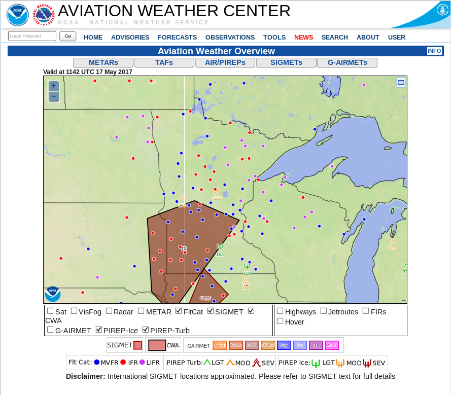
A morning screenshot from the Aviation Weather Center website shows a wide region of IFR and Low IFR Conditions reported over the Upper Midwest, from eastern North Dakota eastward to Lake Superior. The GOES-R IFR Probability field, above, from 1100 UTC on 17 May 2017, shows high probabilities over that region.
Over much of Minnesota and Michigan, the character of the IFR Probability field is flat. This is typical of IFR Probability when high clouds prevent satellite data from being used as a statistical predictor for IFR Conditions. If high clouds are present, the satellite cannot detect the presence of low clouds, and the chief predictor of IFR conditions will therefore be model data that typically does not vary strongly from gridpoint to gridpoint when IFR conditions are present. The pronounced boundary apparent in the IFR Probability field that extends nortwestward from Green Bay in Wisconsin is the boundary between night-time predictors (to the west) and daytime predictors (to the east).
GOES-R IFR Probability values are largest in the region of IFR conditions over North Dakota. In this region, high clouds are not present and the satellite is able to detect low clouds, and that information is part of the computation of IFR Probabilities. Note also the region in east-central Minnesota where satellite data are also being used in the computation of IFR Probabilities; the resultant field there is pixelated.
The toggle below shows the brightness temperature difference field between the shortwave and longwave infrared window channels from GOES-13 (3.9 µm and 10.7 µm) and GOES-16 (3.9 µm and 10.33 µm). This brightness temperature difference field is used to detect stratus, and by inference fog, because stratus cloud tops composed of water droplets emit radiation around 10.3-10.7 µm as a blackbody, but do not emit 3.9 µm radiation as a blackbody. Satellite detection of radiation, and computation of the inferred temperature of the emitting surface, assumes blackbody emissions. Consequently, the brightness temperature computed using detected 3.9 µm radiation is colder than that computed using 10.7 µm (or 10.33 µm) radiation.
Both satellites capture the region of low stratus/fog over North Dakota, and the superior spatial resolution of GOES-16 is apparent. Note, however, that neither satellite can detect low clouds associated with dense fog in regions of higher clouds — over Michigan’s Keewenaw Peninsula, for example, or along the shore of Lake Superior in Minnesota. This is an unavoidable shortcoming of satellite-only-based detection of low clouds/fog.

GOES-13 (3.9 µm – 10.7 µm) and GOES-16 (10.33 µm – 3.9 µm) Brightness Temperature Difference fields, 1100 UTC on 17 May 2017 (Click to enlarge)