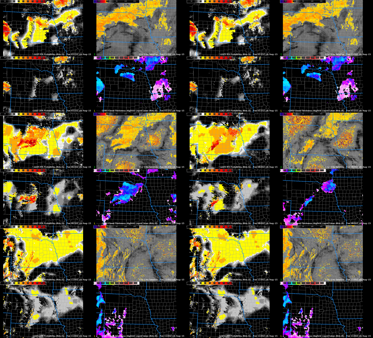
GOES-R IFR Probability (Upper Left), GOES-R Low IFR Probability (Lower Left), GOES-13 Brightness Temperature Difference Field (10.7 µm – 3.9 µm) (Upper Right), GOES-R Cloud Thickness (Lower Right), Times as Indicated (Click to enlarge)
GOES-R IFR Probability fields, above, suggest IFR conditions are developing over central Nebraska during the early morning of 18 August 2015. Several aspects of the field require comment. At the beginning of the animation, there are noticeable north-south oriented lines in the IFR and Low-IFR Probability fields. These are artifacts of determining the saturation in the lowest 1000 feet of the model as discussed here. As the model saturation deepened over the course of the night, those parallel lines disappeared.
The flat nature of the field announces that satellite data are not being used in the computation of IFR Probability because multiple cloud layers are present. Model fields lack the fine spatial resolution of GOES Satellite data. Where breaks in the clouds do occur, GOES-R IFR Probability fields increase in value (because cloud predictors can be used, and their use enhances the ability of the algorithm to predict whether fog/low clouds are present): Temper your interpretation of the magnitude of the IFR Probability with knowledge of presence of clouds.
Note that the Brightness Temperature Difference field at 0500 UTC has much larger values. Stray Light is beginning to impinge on satellite fields as the calendar gets closer to the Equinox. This issue will remain through mid-October. Multiple cloud decks over Nebraska on 18 August greatly hampered the ability of the brightness temperature difference field to identify regions of low clouds.
The GOES-R Cloud Thickness fields are displayed; these are derived from an empirical relationship between 3.9 µm emmissivity and cloud thickness derived from SODAR data off the west coast of the United States. When multiple cloud layers are present, this field is not computed (nor is it displayed around sunrise/sunset). Thus, you should not see Cloud Thickness fields in regions where GOES-R IFR Probability fields are very smooth (suggesting that only model data are being used). The regions where Cloud Thickness is displayed, above, correspond to regions in the IFR Probability field that are pixelated (that is, where satellite data are being used).
Fog formation is aided by increasingly long nights. Nights now are above 90 minutes longer in Hastings than they were at the Summer Solstice.
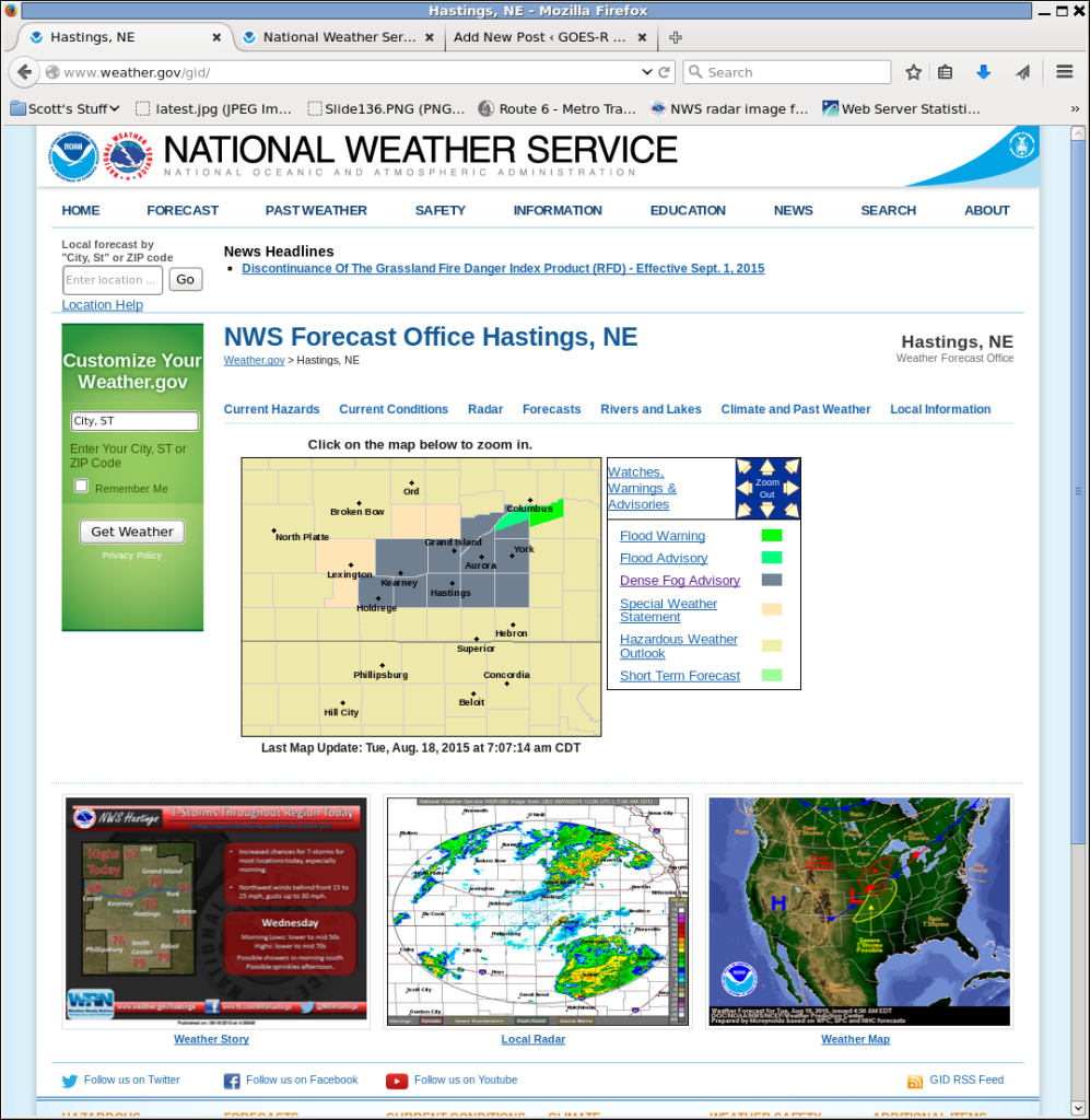
The text for the advisory is below:
URGENT - WEATHER MESSAGE
NATIONAL WEATHER SERVICE HASTINGS NE
608 AM CDT TUE AUG 18 2015

...DENSE FOG PERSISTING FOR A FEW HOURS THIS MORNING...

NEZ048-049-061>064-073>077-181400-
/O.NEW.KGID.FG.Y.0006.150818T1108Z-150818T1400Z/
MERRICK-POLK-BUFFALO-HALL-HAMILTON-YORK-PHELPS-KEARNEY-ADAMS-CLAY-
FILLMORE-
INCLUDING THE CITIES OF...CENTRAL CITY...STROMSBURG...OSCEOLA...
SHELBY...POLK...KEARNEY...GRAND ISLAND...AURORA...YORK...
HOLDREGE...MINDEN...HASTINGS...SUTTON...HARVARD...CLAY CENTER...
EDGAR...FAIRFIELD...GENEVA...EXETER...FAIRMONT
608 AM CDT TUE AUG 18 2015

...DENSE FOG ADVISORY IN EFFECT UNTIL 9 AM CDT THIS MORNING...

THE NATIONAL WEATHER SERVICE IN HASTINGS HAS ISSUED A DENSE FOG
ADVISORY...WHICH IS IN EFFECT UNTIL 9 AM CDT THIS MORNING.

* VISIBILITY...REDUCED TO 1/4 MILE OR LESS ACROSS MUCH OF THE
  ADVISORY AREA...INCLUDING THE INTERSTATE 80 AND HIGHWAY 6
  CORRIDORS. THE COMBINATION OF RAIN MOVING INTO PARTS OF THE
  AREA...ALONG WITH A COLD FRONT MOVING IN FROM THE WEST...SHOULD
  HELP TO GRADUALLY IMPROVE DENSE FOG ISSUES.

* IMPACTS...DENSE FOG WILL GREATLY AFFECT THE MORNING COMMUTE IN
  SOME AREAS...AND MOTORISTS ARE URGED TO DRIVE WITH CAUTION AND
  PREPARE FOR RAPID CHANGES IN VISIBILITY OVER SHORT DISTANCES.

PRECAUTIONARY/PREPAREDNESS ACTIONS...

A DENSE FOG ADVISORY MEANS VISIBILITIES WILL FREQUENTLY BE
REDUCED TO LESS THAN ONE QUARTER MILE. IF DRIVING...SLOW DOWN...
USE YOUR HEADLIGHTS...AND LEAVE PLENTY OF DISTANCE AHEAD OF YOU.

&&

$$

PFANNKUCH

