Monthly Archives: July 2014

Fog and low stratus over the North Carolina piedmont

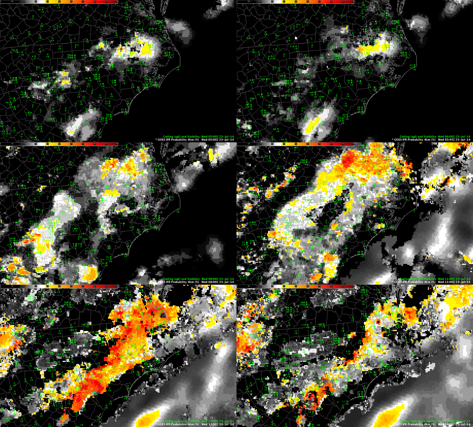
NC_FLS_23July2014loop

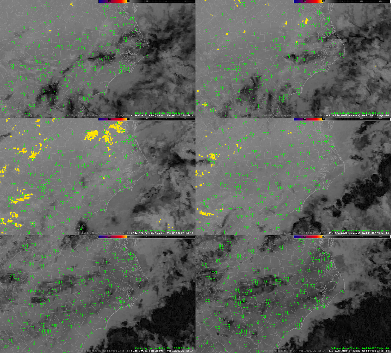
Hourly imagery of GOES-R IFR Probabilities over North Carolina, 0500-1400 UTC 23 July 2014, including surface observations of ceilings and visibilities

Low ceilings and reduced visibilities developed along the North Carolina piedmont during the morning of July 23rd. GOES-R IFR Probabilities showed the stripe of low ceilings/reduced visibilities extending northeast to southwest along the Piedmont. Observed IFR and near-IFR conditions roughly correlate with higher probabilities in the field displayed. Note that probabilities increase between 1100 and 1200 UTC, when the Sun rises and different predictors are used to compute the fields.

In contrast, the brightness temperature difference field (below) does not have a strong signal, it would be difficult to use the fields to predict where fog/low stratus would be.

GOES-R IFR Probabilities allow a better description of where fog/low stratus exists because of the use of Rapid Refresh data as a predictor of fog. In cases where the satellite signal is not strong, such as this one, saturation information from the model adds critical information.

NC_BTD_23July2014loop

Hourly imagery of GOES-13 Brightness Temperature Differences (10.7 µm – 3.9 µm) over North Carolina, 0500-1400 UTC 23 July 2014, including surface observations of ceilings and visibilities

MODIS and GOES IFR Probabilities in the Pacific Northwest

PacNW_15Julyloop

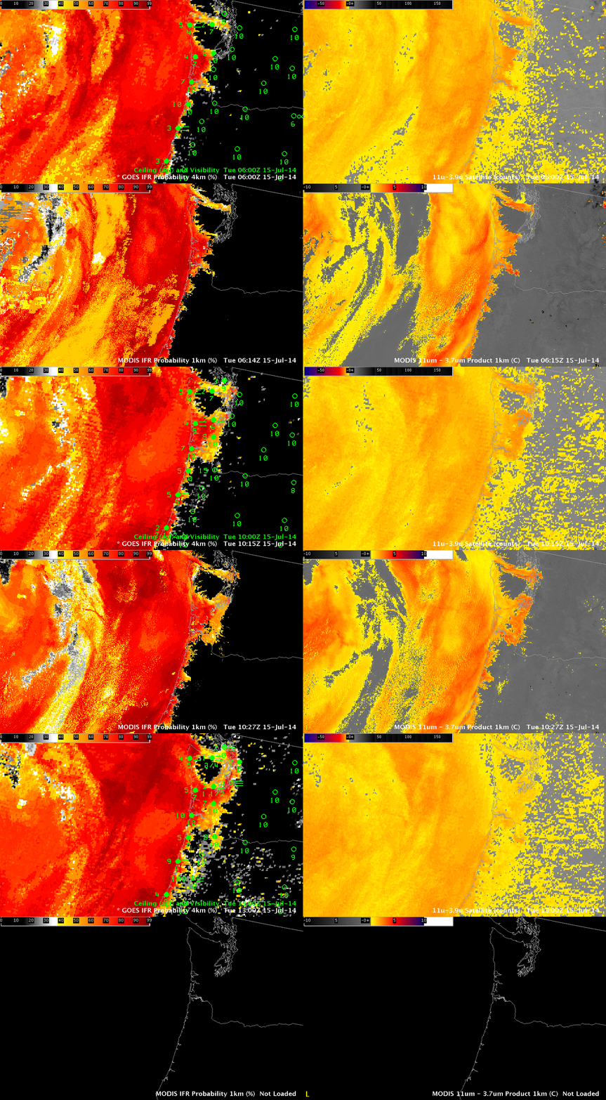
IFR Probabilities (Left) from GOES-15 Imager (Upper Left) and MODIS (Lower Left), Brightness Temperature Difference (11 µm – 3.9 µm) (Right) from GOES-15 Imager (Upper Right) and MODIS (Lower Right). Terra data used at 0614 UTC, Aqua data used at 1027 UTC. All times as indicated. (Click to enlarge)

The Pacific Northwest is far from the sub-satellite point of GOES-West. Pixel size there is therefore greater than the nominal 4-km size at the sub-satellite point: Pixel size is more like 8 kilometers in the north-south by 5 kilometers in the east-west. The animation above shows GOES- and MODIS-based IFR Probabilities and Brightness Temperature Difference Products.

Both GOES and MODIS IFR Probabilities show an expansion (as observed) of reduced ceilings and visibilities as marine stratus penetrates inland over coastal Washington and Oregon. The visibility at Seattle drops as the high probabilities overspread the region. MODIS resolution is better able to depict the fingers of fog/stratus that penetrate up river valleys along the coast. GOES Temporal resolution, however, means that frequent updates are available. (Note the lack of MODIS data at 1300 UTC).

The brightness temperature difference fields from GOES and MODIS are different. The GOES field has a considerable false signal (as far as fog is concerned) related to changes in surface emissivity that occur in the arid intermountain west during summer. MODIS fields show less of this false signal because of differences in the spectral width of the channels.

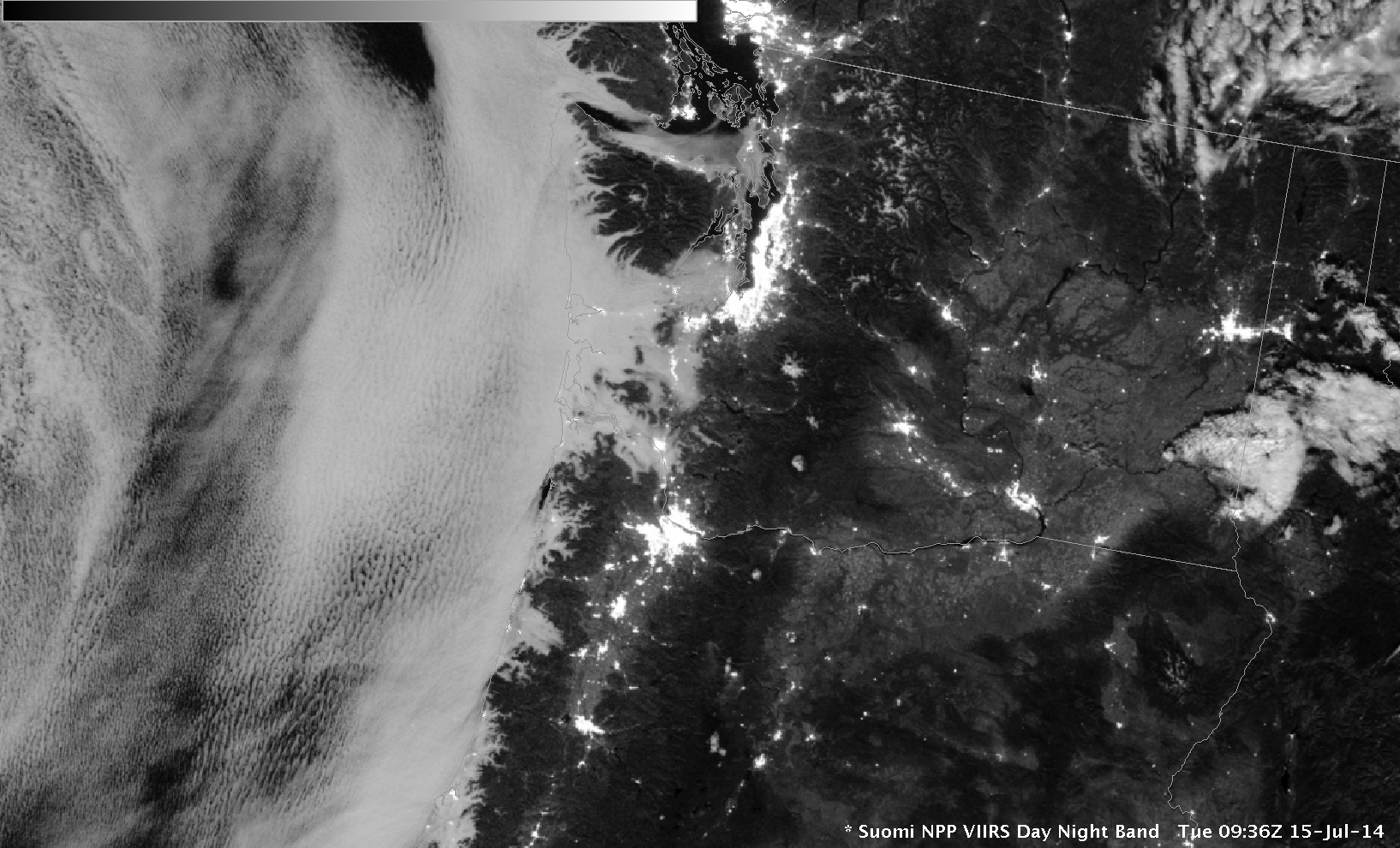
The Day/Night band on Suomi NPP, below, also shows the extent of stratus over coastal Oregon and Washington. This visible image uses reflected lunar light for illumination.

SNPP_DNB_0936UTC_15July2104

Suomi NPP VIIRS Day Night Band, 0936 UTC, 15 July 2014

Dense Fog Advisories over Missouri

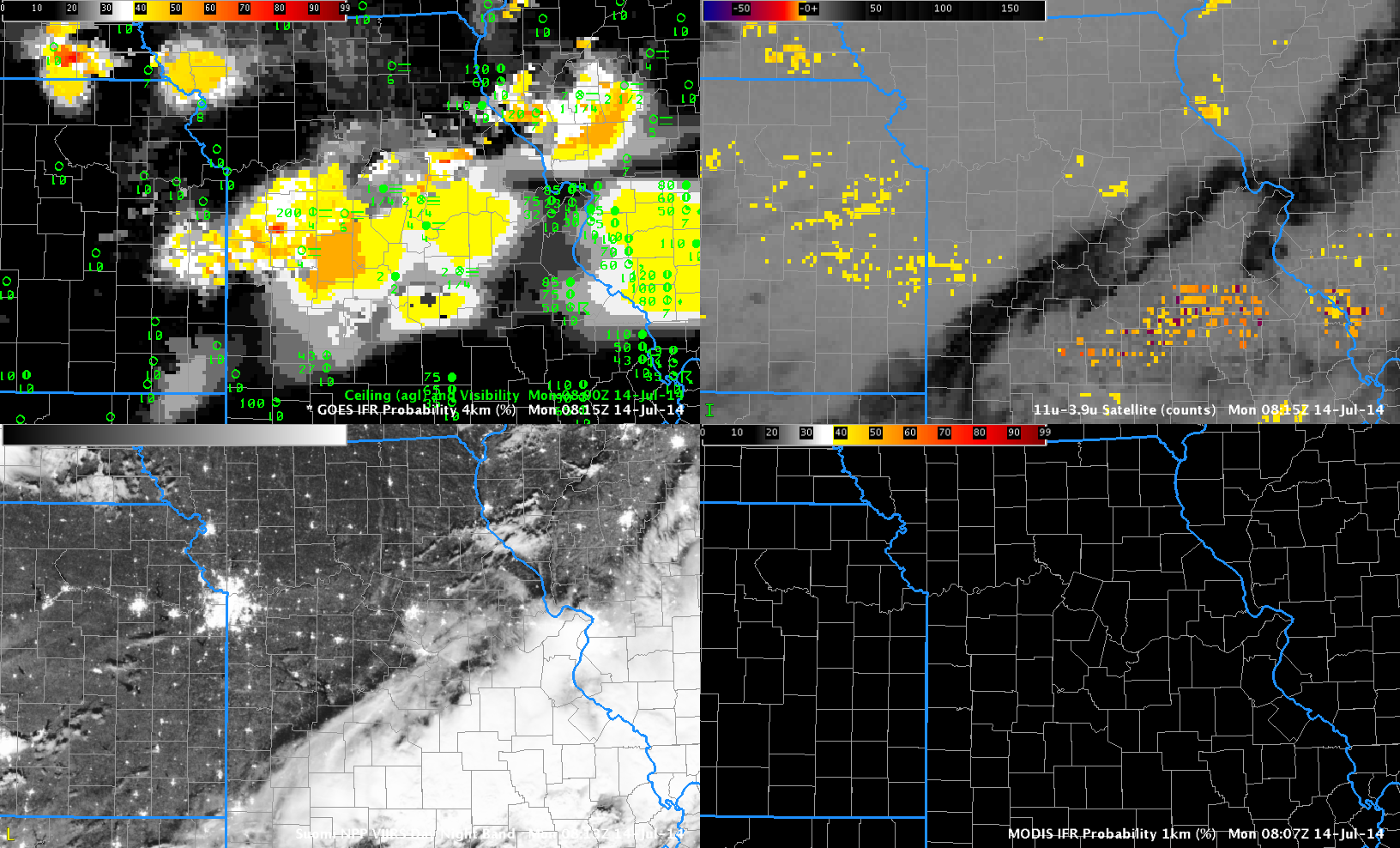
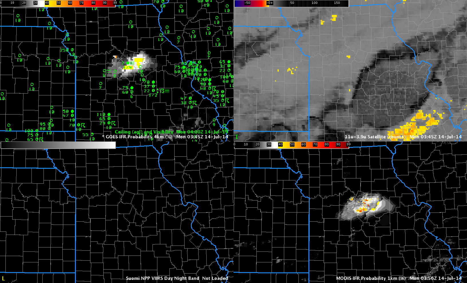
CentralMissouri_14July2014loop

GOES-R IFR Probabilities (Upper Left), GOES-East Brightness Temperature Difference (10.7 µm – 3.9 µm) (Upper Right), Suomi/NPP Day/Night Band imagery (Lower Right), MODIS-based IFR Probabilitiy (Lower Left), times as indicated (Click to animate)

Moisture from departing late-day thunderstorms allowed for the development of dense fog over central Missouri overnight. The GOES-based IFR Probabilities, above, capture the low ceilings and reduced visibilities that developed. The traditional method of fog detection, the brightness temperature difference (BTD) between the 10.7 µm and 3.9 µm fields, was hampered by mid- and high-level clouds associated with the departing convection.

Polar-orbiting satellites such as Terra, Aqua and Suomi NPP can give high-resolution views of developing fog. In the present case, Terra overflew the region near 0400 UTC. The image below shows enhanced MODIS-based IFR Probabilities confined to central Missouri. An Aqua overpass at ~0800 UTC similarly gave a high spatial resolution view of the area. Of course, Terra and Aqua and Suomi NPP only give occasionaly snapshots. To see the ongoing development, temporal resolution as from GOES is key. But the polar orbiters can give an early alert if developing fog starts out at small scales that might be sub-pixel scale in GOES.
CentralMissouri_14July2014-18

As above, but at 0400 UTC 14 July 2014 (Click to enlarge)

From the National Weather Service in St. Louis:

URGENT – WEATHER MESSAGE
NATIONAL WEATHER SERVICE ST LOUIS MO
527 AM CDT MON JUL 14 2014

MOZ041-047>051-059-141400-
/O.NEW.KLSX.FG.Y.0002.140714T1027Z-140714T1400Z/
BOONE MO-CALLAWAY MO-COLE MO-GASCONADE MO-MONITEAU MO-
MONTGOMERY MO-OSAGE MO-
INCLUDING THE CITIES OF…COLUMBIA…JEFFERSON CITY
527 AM CDT MON JUL 14 2014

…DENSE FOG ADVISORY IN EFFECT UNTIL 9 AM CDT THIS MORNING…

THE NATIONAL WEATHER SERVICE IN ST LOUIS HAS ISSUED A DENSE FOG
ADVISORY…WHICH IS IN EFFECT UNTIL 9 AM CDT THIS MORNING.

* TIMING…DENSE FOG HAS DEVELOPED AND WILL CONTINUE THROUGH 900
AM.

* VISIBILITIES…ONE QUARTER MILE OR LESS AT TIMES.

* IMPACTS…SIGNIFICANTLY REDUCED VISIBILITIES WILL LEAD TO
HAZARDOUS DRIVING CONDITIONS.

PRECAUTIONARY/PREPAREDNESS ACTIONS…

A DENSE FOG ADVISORY IS ISSUED WHEN DENSE FOG WILL SUBSTANTIALLY
REDUCE VISIBILITIES…TO ONE-QUARTER MILE OR LESS…RESULTING IN
HAZARDOUS DRIVING CONDITIONS IN SOME AREAS. MOTORISTS ARE ADVISED
TO USE CAUTION AND SLOW DOWN…AS OBJECTS ON AND NEAR ROADWAYS
WILL BE SEEN ONLY AT CLOSE RANGE.

&&

$$

The aviation portion of the AFD from St. Louis mentioned the probability of fog at 0800 UTC; the 1129 UTC update discussed the fog that was present over central Missouri:

&&

.AVIATION: (For the 12z TAFs through 12z Tuesday Morning)
Issued at 609 AM CDT Mon Jul 14 2014

The first concern for this TAF package is that for low ceilings
and fog that have developed in the wake of precipitation that
exited the area overnight. In central MO and including KCOU, fairly
widespread dense fog has reduced visibilities to under 1/4SM for
much of the night. Further east and including metro area TAF sites,
trends indicate the potential for IFR cigs and MVFR visibility for
the first couple hours of the period. However, all sites affected
by fog should see an improvement through the morning hours as
ceilings lift and fog burns off. The second concern is that of a
second cold front, poised to move through the area today.
Currently, the cold front extends from roughly KDBQ southwestward
along the Missouri/Illinois border and just south of KAFK. While
showers may develop along the front as it moves through KUIN
during the late morning/early afternoon, greater instability
exists further south and east. Have currently continued VCSH
mention at KUIN and KCOU, and VCTS for metro TAF sites this
afternoon as the cold front moves through. Uncertainties regarding
coverage and exact timing preclude any TEMPO groups at this time.
The front should be south of all area TAF sites by 21Z, at which
time winds will have veered to the northwest and increased to
around 10-14KT. Winds will remain northwesterly through the end of
the period in the wake of the front, and while a mostly VFR
forecast is expected, reductions in ceilings/visibility may occur
with any storms that move over the terminals.
Distinguishing between stratus and fog over Pennsylvania

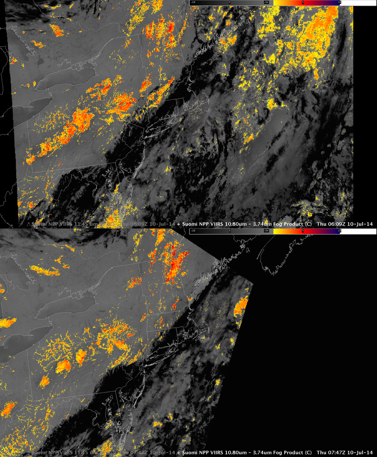
SNPP_11.35_0609_0747_10July2014

Suomi NPP 11.35 µm Infrared Imagery at 0609 and 0752 UTC, 10 July 2014 (Click to enlarge)

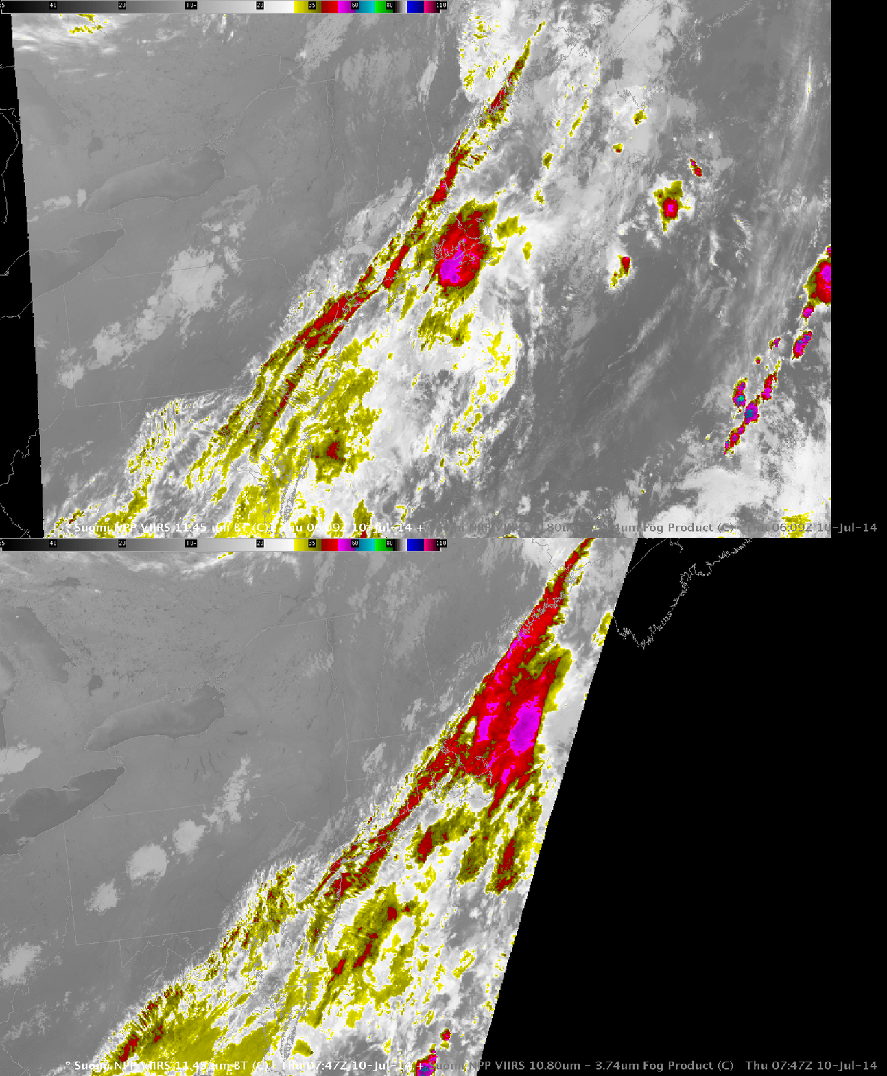
The orbital geometry of Suomi NPP allowed two high-resolution images of Pennsyvlania early in the morning of the 10th of July 2014. Can you tell from the imagery above if there is fog/stratus in the river valleys of Pennsyvlania? Are the relatively cool clouds from Pittsburgh northeastward towards Elmira, NY obstructing visibilities? Based on the IR (11.35 µm for Suomi NPP) imagery alone, above, that is a difficult question to answer. Historically, the brightness temperature difference between the longwave IR (11.35 µm) and the shortwave IR (3.74 µm) has been used to indentify water-based clouds. Imagery from Suomi NPP, below, highlights where water-based clouds (like stratus) exist. If the clouds are the same temperature as the surrounding land (likely the case for river fog), a single 11.35-µm image is of little help in identifying the clouds.

SNPP_11.35-3.74_0609-0747UTC_10July2014

Suomi NPP 11.35 – 3.74 µm Brightness Temperature Difference at 0609 and 0752 UTC, 10 July 2014 (Click to enlarge)

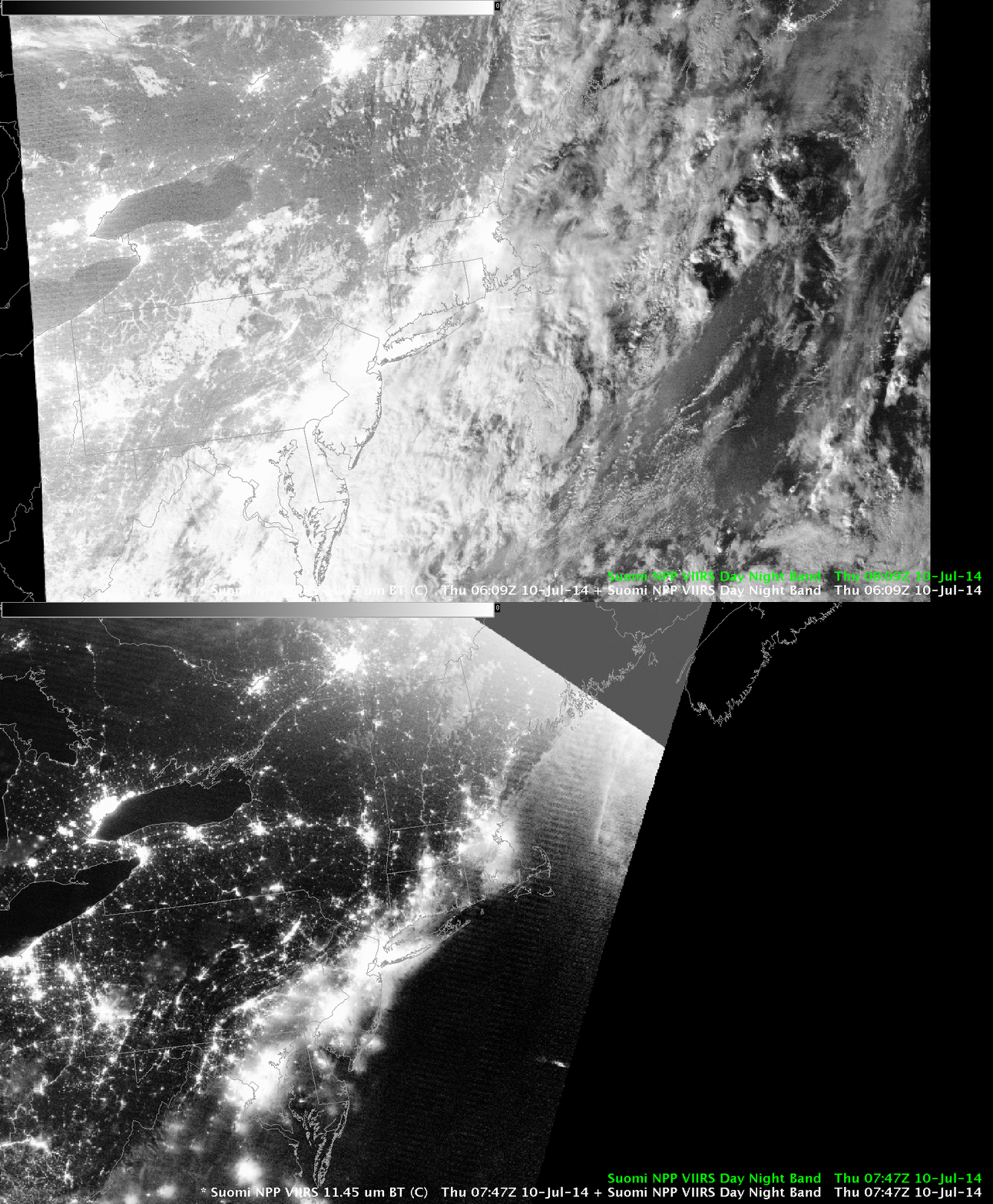
The Day-Night band can also highlight where clouds exist, because lunar illumination reflects well off clouds. A 3/4-full moon ably illuminates the scene at 0609 UTC, but that moon has set at 0747 UTC and the Clouds are harder to see.

SNPP_DNB_0609-0747UTC_10July2014

Suomi NPP Day/Night Band at 0609 and 0752 UTC, 10 July 2014 (Click to enlarge)

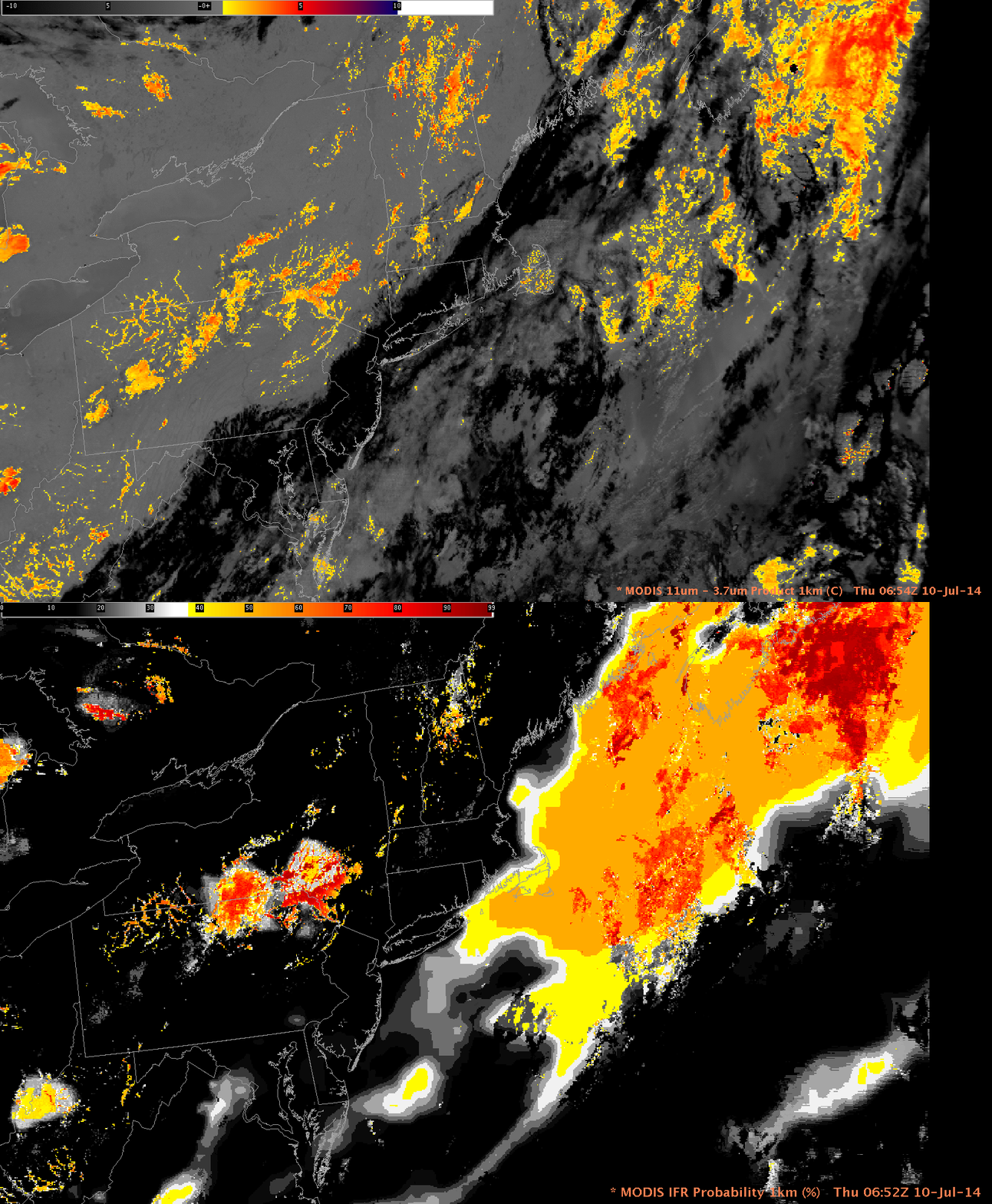
Both the Day/Night band and the Brightness Temperature Difference Fields (and any Infrared image) gives information about the top of the cloud. Fog existence is difficult to discern only from satellite data because the bottom of the cloud is not sampled. This is why a fused product (such as IFR Probability) that includes surface information (in the case of IFR Probability from the Rapid Refresh Model) is desirable. MODIS data can be used to compute IFR Probability, and a MODIS-carrying Aqua pass occurred in between the two Suomi NPP Passes shown above.

MODIS_BTD_IFR_0652UTC_10July2014

MODIS 11 – 3.9 µm Brightness Temperature Difference and IFR Probability at 0652 UTC, 10 July 2014 (Click to enlarge)

In the two images above, note how the IFR Probability Fields de-emphasize the low cloud areas that stretch northeastward from Pittsburgh towards Elmira. This is likely mid-level stratus. River Fog over northeast Pennsylvania is highlighted in the IFR Probability fields (and in the brightness temperature difference field). This image, which shows the GOES-based IFR Probability field at 0645 UTC, highlights the power of MODIS’ superior spatial resolution in the early detection of small-scale fog. The large region of reduced visibility around Elmira NY (meager surface observations suggest this large region of fog verified) appears in both MODIS- and GOES-based IFR Probability fields. Only the MODIS-based IFR Probability field, however, has a distinct river-valley signal over northeast Pennsylvania.

MODIS and GOES IFR Probability both suggest IFR conditions may be occurring over the Atlantic Ocean. The brightness temperature difference field shows no low cloud signal there because of a cirrus shield. IFR Probability gives a signal of fog here based on information from the Rapid Refresh.