Daily Archives: July 25, 2012

IFR Probabilities under a Thick Cloud Deck

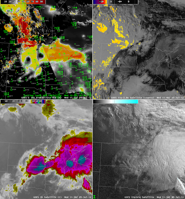
GOES-R IFR Probabilities at 1132 UTC with 1200 UTC surface Observations (Upper left), GOES-East Brightness Temperature Difference (10.7 micrometer brightness temperature – 3.9 micrometer brightness temperature) at 1130 UTC (upper right), GOES-East 10.7 micrometer brightness temperature (lower left) and GOES-East Visible imagery at 1130 UTC (lower right).

Convection developed over the upper Midwest and northern Plains during the early morning hours of 25 July 2012.  Deep convective clouds preclude the ‘traditional’ brightness temperature difference method of fog detection:  emissions from the low-level water-based clouds cannot be seen by the satellite because of high-level cirrus clouds associated with thunderstorm anvils.  IFR conditions nevertheless can occur and can be predicted using model-based predictors in the fused GOES-R IFR probability product.  The case above is an excellent example.

The bottom two images show the tradiational satellite imagery, telling the tale of a departing mesoscale system.  It leaves in its wake low clouds over North Dakota and Manitoba that are detected by the traditional product, and notice how the GOES-R IFR probabilities are highest here, because satellite and model predictors both agree.  Under the convective cloud canopy, probabilities are lower:  around 40% in central North Dakota (where night-time predictor relationships are being used) and around 55% over the Arrowhead of Minnesota (where daytime predictor relationships are being used);  the terminator boundary is very obvious in the IFR Probability figure.  There is an excellent overlap between the GOES-R IFR Probabilities and reported IFR conditions that is impossible to get in this case with satellite information alone.

GOES-R IFR as a ‘cleaner’ Product

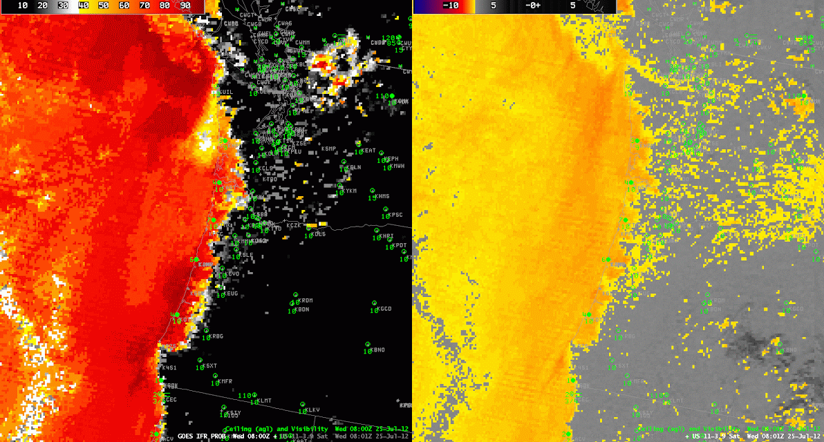
Image toggle between 0800 UTC GOES-R IFR Probability and GOES-West Brightness Temperature Difference between 10.7 and 3.9 micrometers

Because the GOES-R IFR Probabilty product uses multiple predictors in its computation of probabilities, regions where the satellite returns give erroneous signals — because of soil emissivity property changes, for example — can be suppressed if the Rapid Refresh strongly suggests fog is unlikely in that region.  In this example over the Pacific Northwest on the morning of 25 July, both products correctly suggest IFR conditions are likely along the coast (and observations are congruent with that suggestion).  The ‘traditional’ brightness temperature difference product, however, shows a signal over central and western Washington.  IFR conditions are not present there.  The GOES-R IFR product de-emphasizes the satellite signal there.  This ably demonstrates a benefit in using a fused product.