Scott Bachmeier put together a good blog post on the CIMSS satellite blog showing the GOES-R IFR/LIFR products being used with MODIS over Alaska. The link to it is below:
Fog and stratus deck over the North Slope region of Alaska
Leave a reply
Scott Bachmeier put together a good blog post on the CIMSS satellite blog showing the GOES-R IFR/LIFR products being used with MODIS over Alaska. The link to it is below:
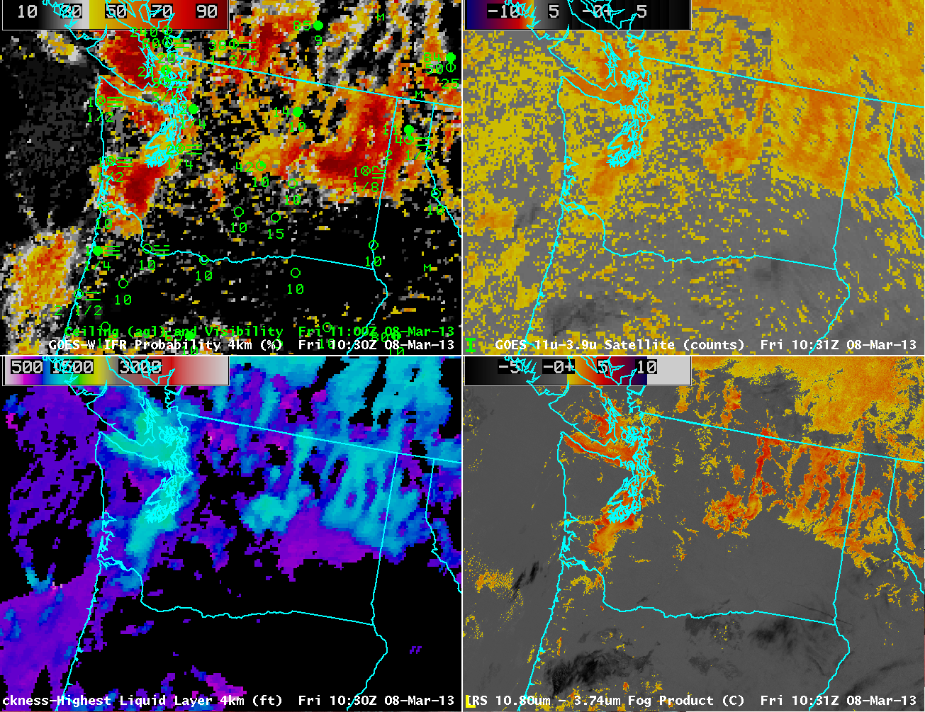 |
| GOES-R IFR Probabilities computed from GOES-West (Upper Left), GOES-E/W Brightness Temperature Difference (10.7 µm – 3.9µm) (Upper Right), GOES-R Cloud Thickness (Lower Left), Suomi/NPP VIIRS Brightness Temperature Difference (Lower Right) |
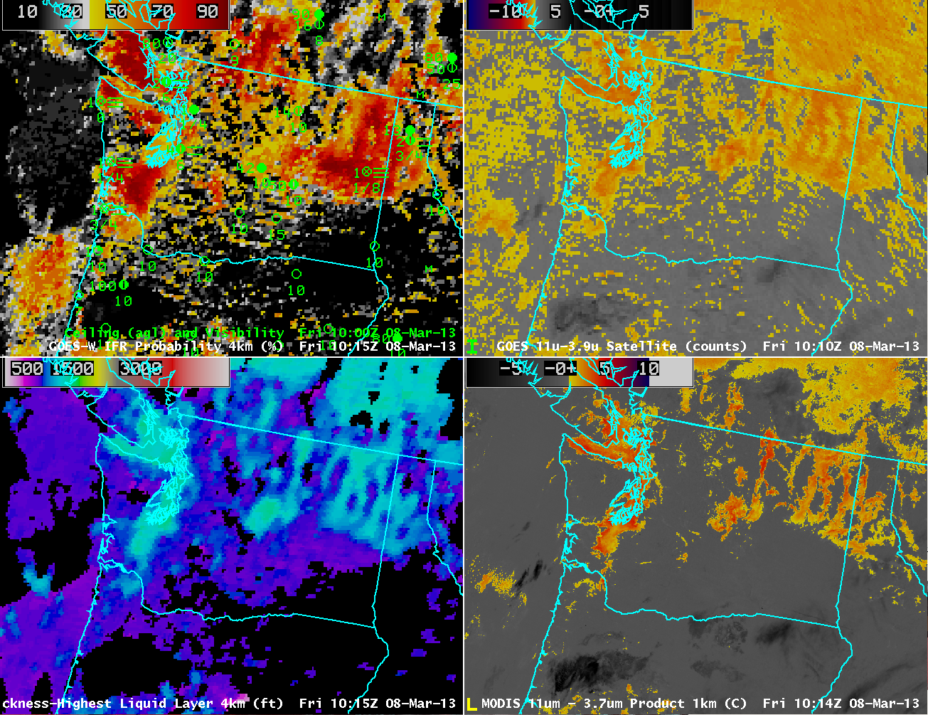 |
| As on top, but with MODIS Brightness Temperature Difference (11 µm – 3.7 µm) in the bottom right. |
The imagery above underscores the power of higher resolution on fog detection. The images on the right side of the images are brightness temperature difference fields, the heritage method for detecting fog and low stratus. The GOES field (top right) actually includes data from GOES-East (eastern Washington and points east — a faint seam is discernible in the image) and GOES-West (western Washington). Pixel size over Washington is large — 6 or 8 kilometers (vs. 4 kilometers at the subsatellite point). In contrast, Suomi/NPP VIIRS data and MODIS data (bottom right) has a resolution of 1 km. The brightness temperature difference from MODIS and VIIRS more easily resolves the fine-scale structure of the topographically influenced or topographically constrained fog and low stratus. The brightness temperature difference field from GOES is one of the predictors used to generate the IFR Probabilities shown in the upper right. When poor resolution smears out the horizontal domain of the fog and low stratus in the brightness temperature difference field, you might expect a similar effect on the IFR probabilities.
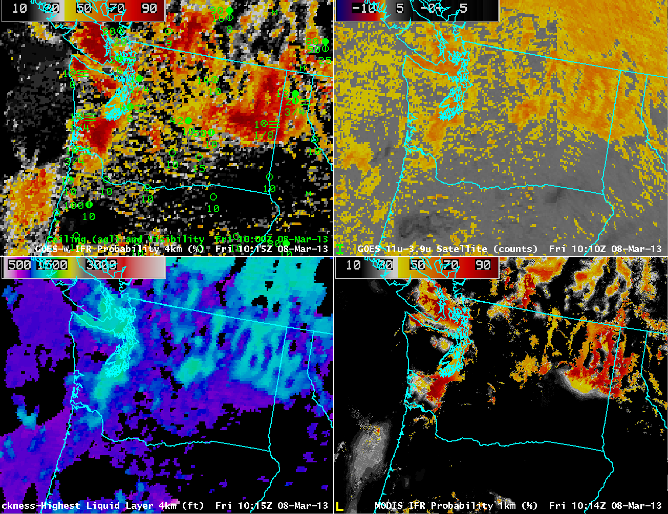 |
| As above, but with MODIS-based GOES-R IFR Probabilities in the lower right |
MODIS data can be used to compute IFR probabilities. Compare the lower right and upper left figures. High MODIS IFR Probabilities are far more restricted to regions where IFR conditions are observed. In contrast, GOES-based IFR probabilities seem to leak into regions where IFR conditions are not reported.
The higher resolution MODIS-based IFR Probabilities (and coming soon, Suomi/NPP-based IFR probabilities) nicely complement the higher temporal resolution of the GOES imagery. Ideally, use of the changes in the GOES-based IFR probabilities shows how IFR conditions evolve over the course of a night. These changes should be tempered with knowledge of the limitations of the horizontal resolution of GOES that are highlighted in the above imagery.
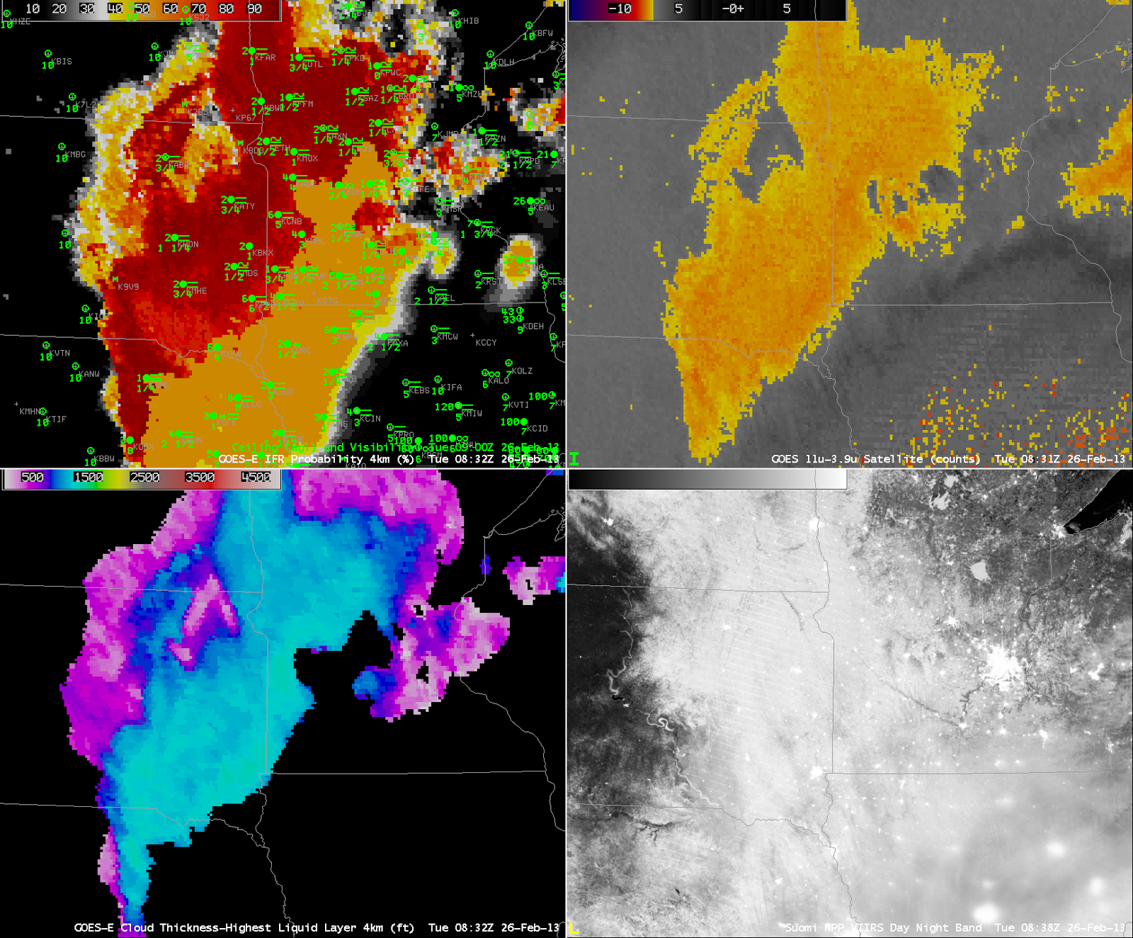 |
| GOES-R IFR Probabilities from GOES-East (Upper Left) at 0832 UTC, along with 0900 UTC observations, Traditional GOES-East Brightness Temperature Difference (10.7 µm – 3.9 µm) at 0832 UTC (Upper Right), GOES-R Cloud Thickness computed from GOES-East (Lower Left), Suomi/NPP Day/Night Band Nighttime visible imagery, 0838 UTC (Lower Left) |
Stratus and low clouds persisted over western Minnesota and the eastern Dakotas overnight on 25 to 26 February, and the GOES-R IFR Probability field ably captured the region of lowest visibility. Note that the IFR probability field extends into northwest Iowa (albeit with relatively lower probabilities). This is a region where high-level cirrus prevents the traditional brightness temperature difference product from giving useful information about the low levels. In this region, Rapid Refresh data are used to fill in information and more accurately capture the region of IFR conditions.
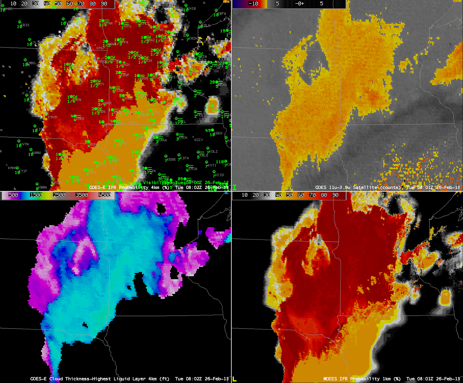 |
| As above, but for 0802 UTC for GOES-East Products, and with the MODIS-based IFR probability field at 0801 UTC in the lower left |
GOES-R IFR Probabilities can be used with MODIS data as well, and the better resolution (1 km at nadir vs. 4 km at GOES nadir) means the MODIS fields have better small-scale detail. Note, for exanple, the sharper edge to the IFR probability field in east-central Minnesota.
 |
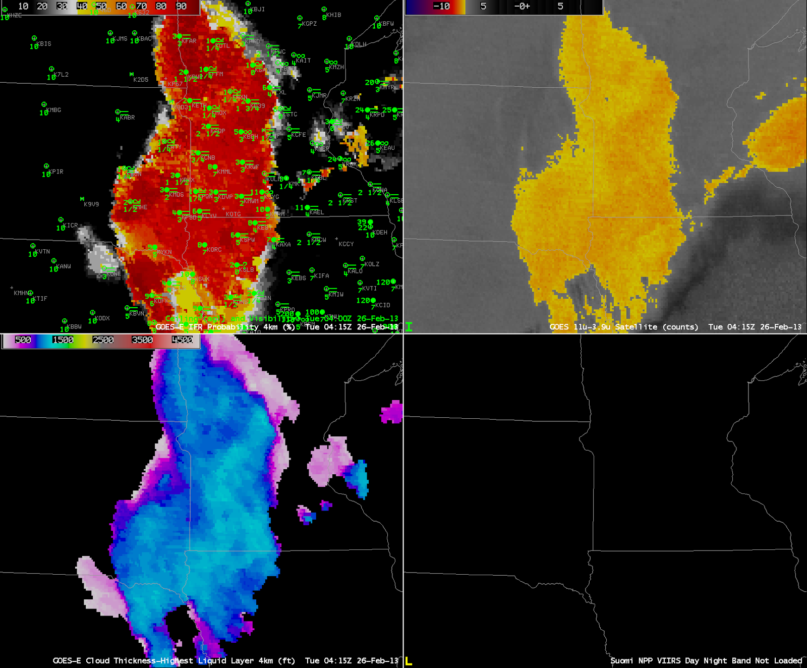
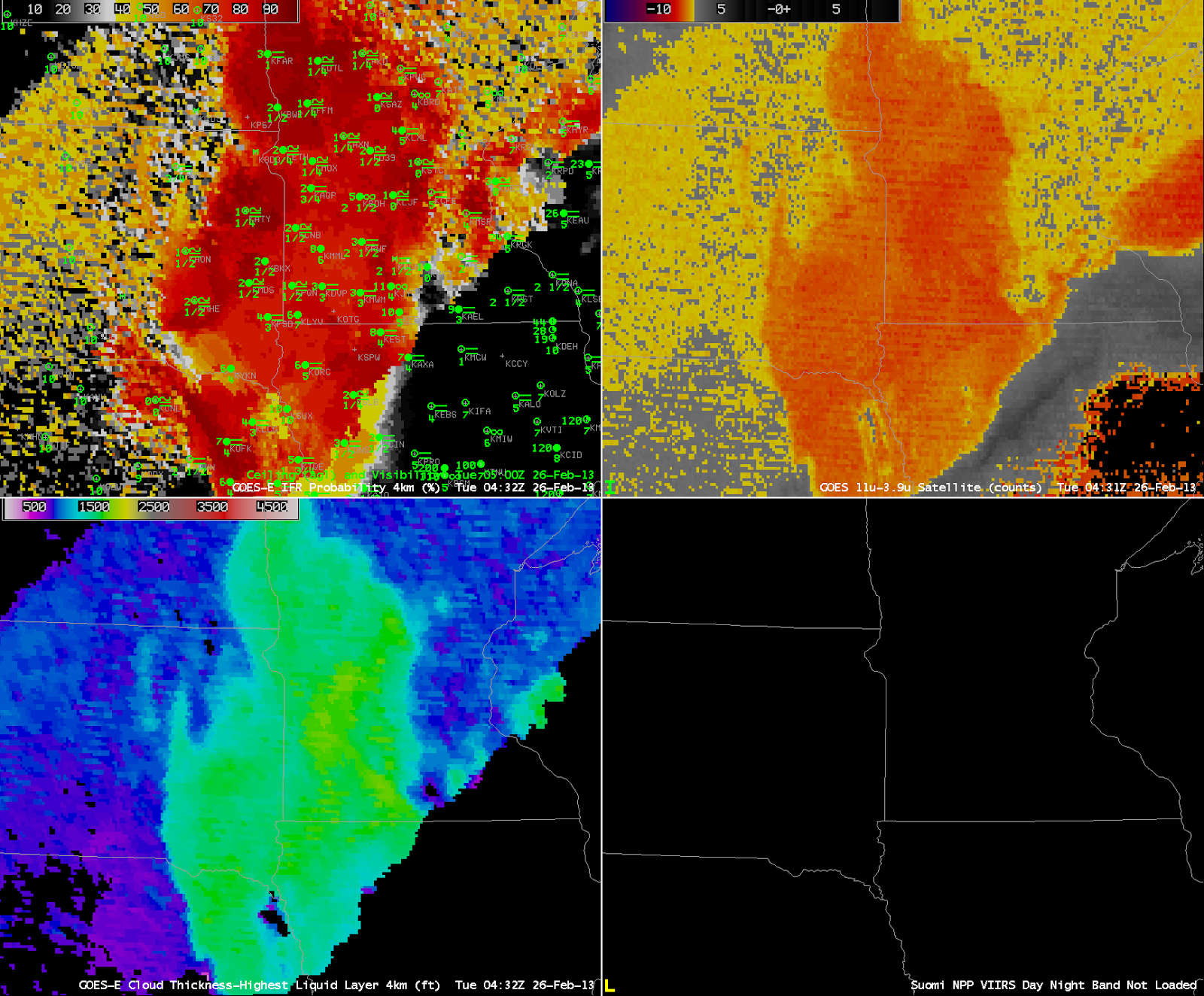
| As at the beginning of the post, except for 0415 UTC (top), 0432 UTC (middle) and 0445 UTC(bottom) |
Stray-light issues can influence the 3.9 µm imagery, and therefore the brightness temperature difference field, and therefore the GOES-R IFR Probability field. In the three images above, Stray Light is noteable in the 3.9 µm at 0432 UTC, but that erroneous information can be de-emphasized in the GOES-R IFR probability field because the Rapid Refresh Data in regions where Stray Light is present may show dryer low levels.
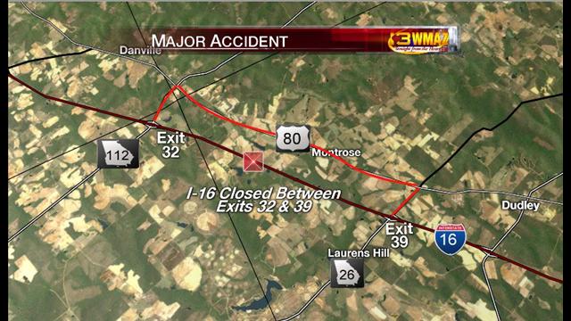 |
| Map of Crash Location, courtesy WMAZ TV in Macon, Georgia |
A multi-vehicle accident with fatalities occurred in extreme western Laurens County in central Georgia early Wednesday Morning, 6 February 2013. (According to this news report, the first crash was around 1310 UTC) Was fog a factor in this accident? Fog was reported in and around the scene as first responders arrived.
Laurens County is in the Peachtree City CWA, and the relevant part of the Forecast Discussion at 0000 UTC is as follows:
000
FXUS62 KFFC 060007
AFDFFC

AREA FORECAST DISCUSSION...UPDATED FOR AVIATION
NATIONAL WEATHER SERVICE PEACHTREE CITY GA
ISSUED BY NATIONAL WEATHER SERVICE BIRMINGHAM AL
705 PM EST TUE FEB 5 2013

.SHORT TERM /TONIGHT THROUGH WEDNESDAY NIGHT/...

FAIRLY QUIET WEATHER THROUGH THE SHORT TERM PERIOD. A WEAK
SHORTWAVE HAS BROUGHT A BAND OF CLOUDS TO THE AREA AND A FEW
SPRINKLES SHOW UP EVERY NOW AND THEN ON RADAR. CLOUDS ARE EXPECTED
TO THIN OUT OVERNIGHT AND FOG COULD BECOME AN ISSUE IN THE FEW
HOURS BEFORE SUNRISE. THIS IS SOMETHING THAT WILL HAVE TO BE
MONITORED THROUGH THE EVENING. MILD TEMPERATURES THROUGH THE
PERIOD.

.LONG TERM /THURSDAY THROUGH TUESDAY/...
[...snipped...]
&&

.AVIATION... 00Z TAF DISCUSSION.

VFR CIGS WILL CONTINUE ACROSS THE TAF SITES THIS EVENING.
EXPECT MVFR CONDITIONS LATE TONIGHT AS FOG AND LOW CLOUDS DEVELOP
BEGINNING AFTER 06Z NEAR CSG SPREADING NORTH AND EAST. THE ATLANTA
TAF SITES SHOULD EXPECT TO BE IMPACTED BY 08-09Z. IMPROVING
CONDITIONS BY 15Z. LIGHT WESTERLY WINDS EXPECTED.
FXUS62 KFFC 060553
AFDFFC

AREA FORECAST DISCUSSION...UPDATED FOR AVIATION
NATIONAL WEATHER SERVICE PEACHTREE CITY GA
ISSUED BY NATIONAL WEATHER SERVICE BIRMINGHAM AL
1245 AM EST WED FEB 6 2013

.SHORT TERM /TONIGHT THROUGH WEDNESDAY NIGHT/...
[...no changes...]
.LONG TERM /THURSDAY THROUGH TUESDAY/...
[...snipped for brevity...]
&&

.AVIATION... 06Z TAF DISCUSSION.

PATCHY CEILINGS BKN030-040 LINGERING THROUGH THE NIGHT. POTENTIAL
FOR LIFR CONDITIONS WHERE SKIES ARE CLEAR...BUT EXPECT ALL TAF SITES
TO HAVE AT LEAST MVFR CONDITIONS 08Z THROUGH 14Z. IMPROVING AFTER
THAT TO VFR. WINDS NORTHWEST 5 TO 10KT AFTER 15Z.


//ATL CONFIDENCE...06Z UPDATE...
MEDIUM CONFIDENCE ON ALL ELEMENTS.
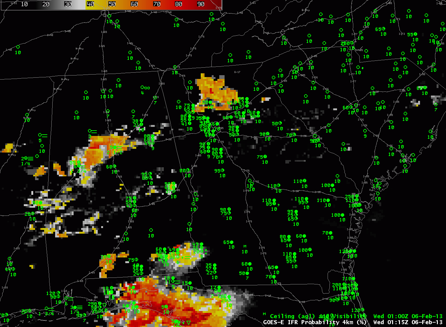 |
| GOES-R IFR Probabilities computed from GOES-East and Rapid Refresh Data, 0115 through 0515 UTC 6 February, along with hourly observations of ceilings/visibility |
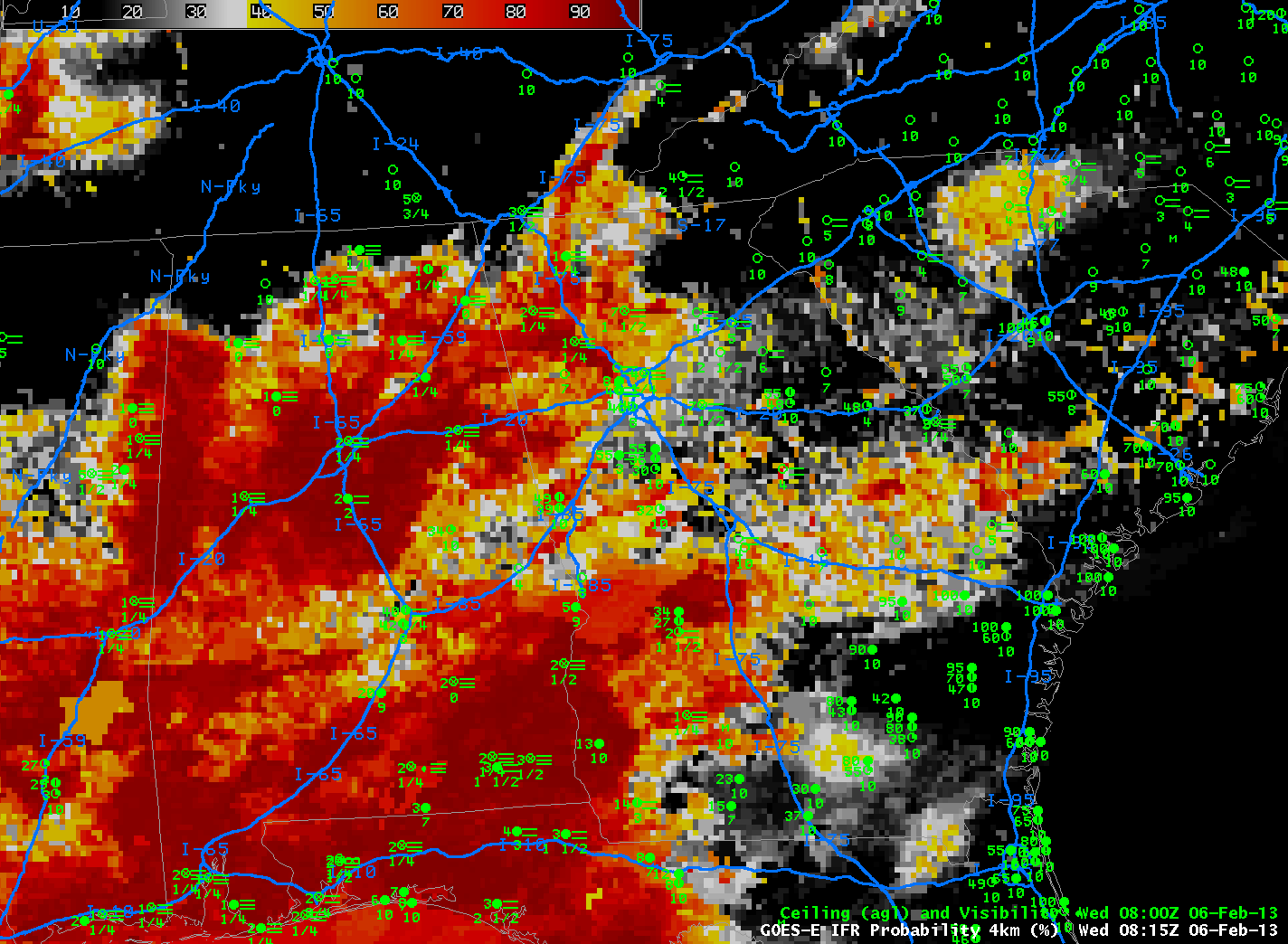 |
| As in the loop above, but for 0815 UTC only. Interstate Highways are denoted in Blue. |
000
FXUS62 KFFC 060930
AFDFFC

AREA FORECAST DISCUSSION
NATIONAL WEATHER SERVICE PEACHTREE CITY GA
430 AM EST WED FEB 6 2013

.SHORT TERM /TODAY THROUGH THURSDAY NIGHT/...
SOME LOW LEVEL MOISTURE REMAINING THIS MORNING AND THIS HAS PRODUCED
FOG ACROSS MANY AREAS. WILL GO AHEAD AND ISSUE A DENSE FOG ADVISORY
SINCE MOST PLACES SEEM TO BE HEADED FOR VERY LOW VISIBILITY.
OTHERWISE DRY HIGH PRESSURE BUILDING OVER THE SOUTHEAST TODAY AND
MOVING OFF THE ATLANTIC COAST TONIGHT. NEXT SHORT WAVE COMING ACROSS
THE NORTHERN GULF SHOULD BEGIN TO AFFECT OUR CWA MAINLY 06Z THURSDAY
AND BEYOND. THIS SOUTHERN STREAM SYSTEM MOVES ACROSS THE STATE
THURSDAY AND THURSDAY NIGHT WITH SOME DIFFERENCES BETWEEN MODELS
WITH LOCATION AND STRENGTH OF SURFACE LOW. IN GENERAL...LOOKS LIKE A
WEDGE SETTING UP LATE TONIGHT INTO THURSDAY WITH MUCH OF THE CWA IN
EASTERLY FLOW. THERE SHOULD BE A SHARP GRADIENT OF TEMPERATURES
BETWEEN NORTH AND CENTRAL ZONES AND FOR NOW HAVE KEPT THE WARMER AIR
ON THURSDAY CONFINED TO COLUMBUS TO MACON AND SOUTH. CATEGORICAL
POPS FOR THURSDAY TAPERING OFF WEST TO EAST THURSDAY NIGHT AS THE
SURFACE LOW MOVES EAST. NO MENTION OF THUNDER AS WEDGE SHOULD BE
STABLE. HOWEVER SOME INSTABILITY COULD PUSH INTO THE CENTRAL ZONES
THURSDAY AFTERNOON ALONG THE BOUNDARY.

41


.LONG TERM /FRIDAY THROUGH TUESDAY/...
[...snipped...]
01

&&

.AVIATION...
06Z TAF DISCUSSION.
PATCHY CEILINGS BKN030-040 LINGERING THROUGH THE NIGHT. POTENTIAL
FOR LIFR CONDITIONS WHERE SKIES ARE CLEAR...BUT EXPECT ALL TAF
SITES TO HAVE AT LEAST MVFR CONDITIONS 08Z THROUGH 14Z. IMPROVING
AFTER THAT TO VFR. WINDS NORTHWEST 5 TO 10KT AFTER 15Z.

//ATL CONFIDENCE...06Z UPDATE...
MEDIUM CONFIDENCE ON ALL ELEMENTS.

41

&&

.PRELIMINARY POINT TEMPS/POPS...
[...snipped...]
 &&

.FFC WATCHES/WARNINGS/ADVISORIES...
DENSE FOG ADVISORY UNTIL 9 AM EST THIS MORNING FOR THE FOLLOWING
ZONES: BALDWIN...BANKS...BARROW...BARTOW...BIBB...BLECKLEY...
BUTTS...CARROLL...CATOOSA...CHATTAHOOCHEE...CHATTOOGA...
CHEROKEE...CLARKE...CLAYTON...COBB...COWETA...CRAWFORD...CRISP...
DADE...DAWSON...DEKALB...DODGE...DOOLY...DOUGLAS...EMANUEL...
FANNIN...FAYETTE...FLOYD...FORSYTH...GILMER...GLASCOCK...
GORDON...GREENE...GWINNETT...HALL...HANCOCK...HARALSON...
HARRIS...HEARD...HENRY...HOUSTON...JACKSON...JASPER...
JEFFERSON...JOHNSON...JONES...LAMAR...LAURENS...LUMPKIN...
MACON...MADISON...MARION...MERIWETHER...MONROE...MONTGOMERY...
MORGAN...MURRAY...MUSCOGEE...NEWTON...NORTH FULTON...OCONEE...
OGLETHORPE...PAULDING...PEACH...PICKENS...PIKE...POLK...
PULASKI...PUTNAM...ROCKDALE...SCHLEY...SOUTH FULTON...SPALDING...
STEWART...SUMTER...TALBOT...TALIAFERRO...TAYLOR...TELFAIR...
TOOMBS...TOWNS...TREUTLEN...TROUP...TWIGGS...UNION...UPSON...
WALKER...WALTON...WARREN...WASHINGTON...WEBSTER...WHEELER...
WHITE...WHITFIELD...WILCOX...WILKES...WILKINSON.

&&

$$

SHORT TERM...41
LONG TERM....01
AVIATION...41
The animation from 0815 UTC through 1315 UTC shows a continued increase in the probabilities over the crash site on I-16. In addition, observations decrease to IFR conditions. Note that at 1315 UTC the switch between nighttime and daytime predictors is present in the image as a southwest to northeast boundary over extreme eastern Georgia. Probabilities are high over the crash site, but by 1415 UTC, they have all but vanished as the fog quickly dissipated at sunrise. This suggests a fog that is not thick, and the GOES-R Cloud Thickness corroborates this assumption (see below)
 |
| As in the loop above, but from 0815 UTC through 1315 UTC. Crash occurred at 1310 UTC |
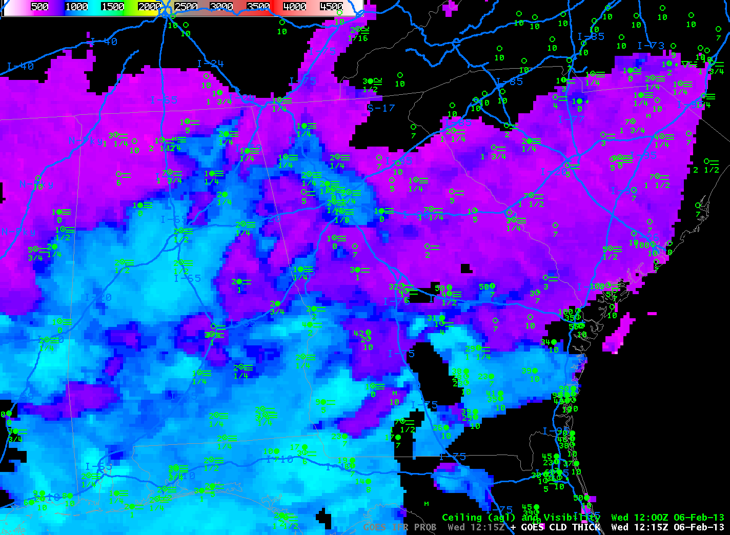 |
| GOES-R Cloud Thickess just before Twilight Conditions, 1215 UTC 6 February. Values near the Crash Site are 600-700 feet. |
 |
| Zoomed-in GOES-13 Visible Imagery over east-central Georgia, times as indicated. Montrose (Yellow square) is indicated within Laurens County (outlined in green) |
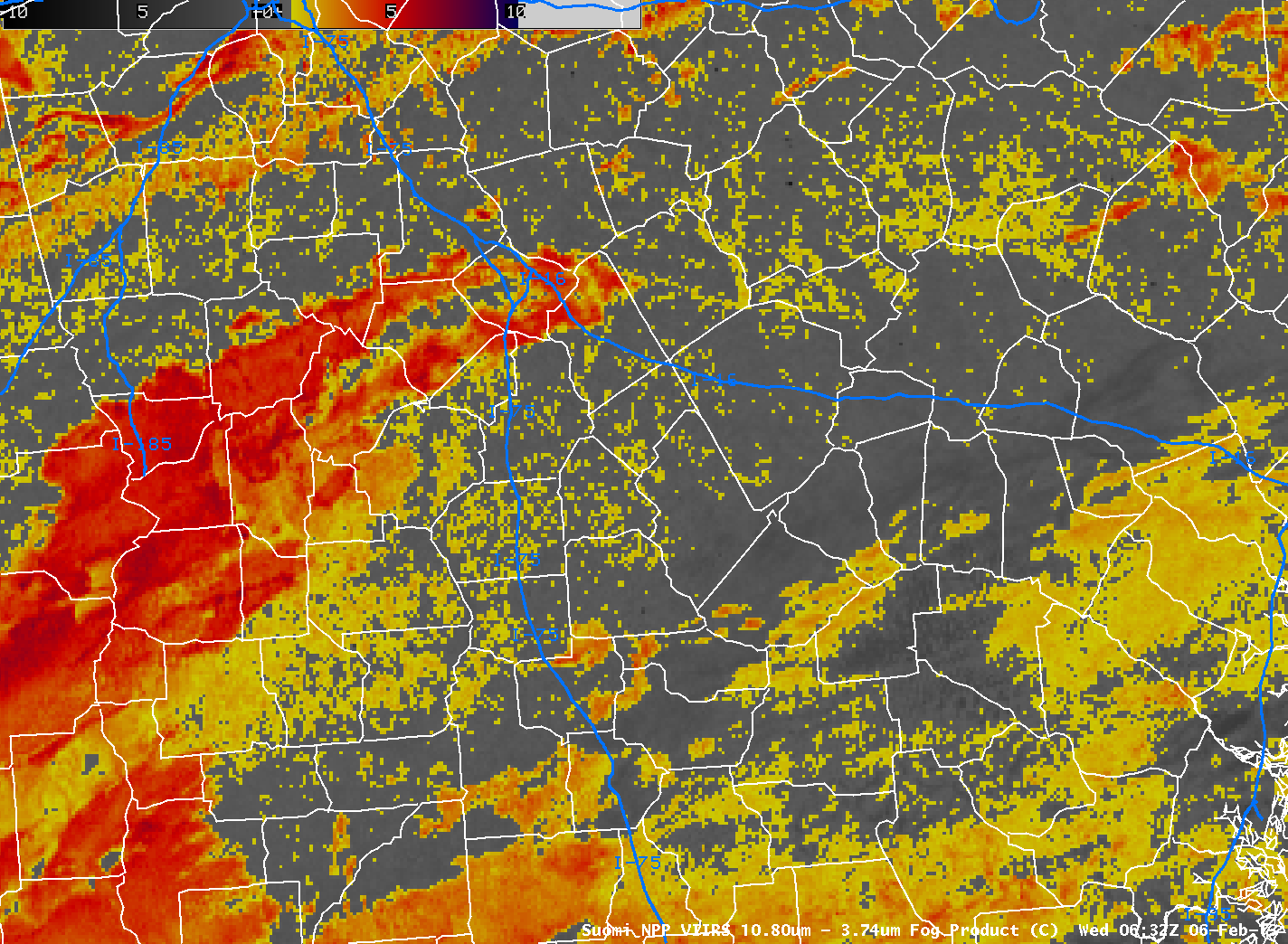 |
| Suomi-NPP Brigthness Temperature Difference (10.80 µm- 3.74 µm) at 0632 UTC and 0811 UTC. Interstate 16 crosses Laurens County near the center of these images. |
MODIS data from Aqua were used to produce IFR probabilities at 0645 UTC, below. This was before the most fog had developed, but it does confirm the picture painted with GOES data’s broader brush: IFR probabilities are increasing over Georgia.
 |
| MODIS-based GOES-R IFR Probabilities over Georgia, 0645 UTC on 6 February 2013. |
Finally, AVHRR data from NOAA-15 from 1015 UTC show widespread stratus extending eastnortheast from southwest Georgia to central Georgia.
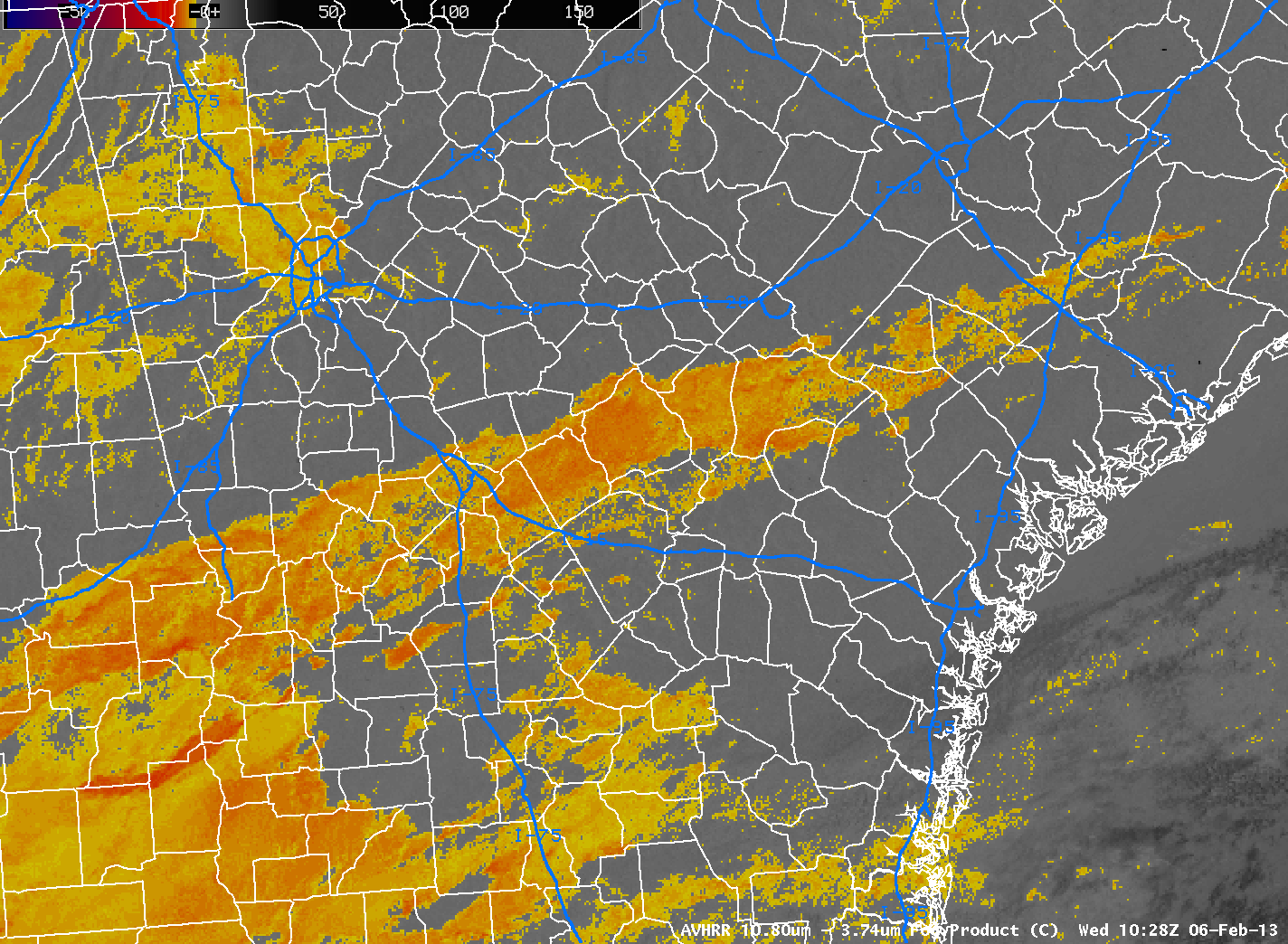 |
| Brightness Temperature Difference (10.8 µm – 3.74 µm) from AVHRR data, 1028 UTC 6 Feb 2013 |
 |
|
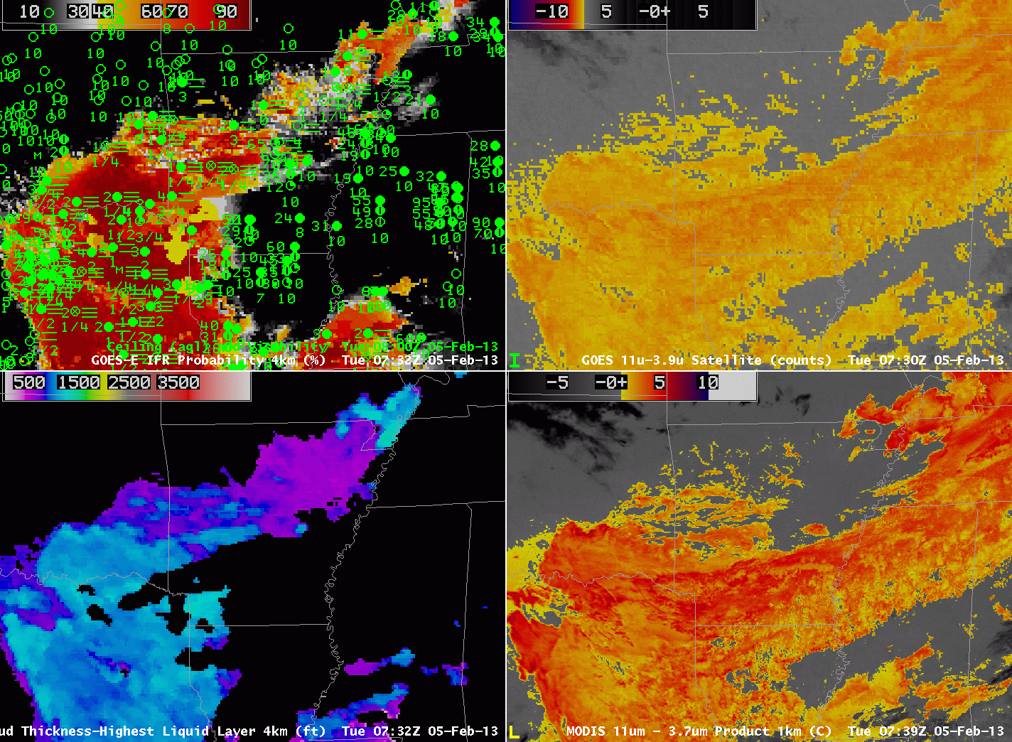
| GOES-R IFR Probabilities, from GOES-East (0732 UTC) and 0800 UTC Surface observations of visibility and ceilings (Upper Left), GOES-E Brightness Temperature Difference (10.8 µm – 3.9 µm) (Upper Right), GOES-R Cloud Thickness (Lower Left), MODIS-based Brightness Temperature Difference (11µm – 3.74 µm) GOES-R IFR Probabilities computed using MODIS data (Lower Left, 0739 UTC) |
IFR conditions developed over Arkansas and surrounding states overnight from 4 into 5 February. Compare the brightness temperature difference (the traditional fog-detection product) over southeast Arkansas (where IFR conditions are not occurring) and over southwest Arkansas (where IFR conditions are present). Although the satellite signal is very similar over the region, surface observations are very different. The GOES-R algorithm distinguishes between the region with IFR conditions (east Texas, western Arkansas, northwest Louisiana) and the region without IFR conditions (southeast Arkansas, northeast Louisiana).
On the flip side, in regions over northeast Arkansas, where the brightness temperature difference product is not showing low clouds, IFR conditions are present, and the GOES-R IFR probability is elevated.
 |
| GOES-R Cloud Thickness over Arkansas just before Dawn — note that dawn has arrived over Tennessee and Mississippi |
Cloud Thickness just before twilight conditions can be used to predict when radiation fog will burn off, using this scatterplot as a guide. The maximum thickness over south-central Arkansas is 1350 feet, and that thickness corresponds to 5 hours after sunrise, or sometime after 1800 UTC. The animation of visible imagery, below, shows that fog/low clouds are lingering over parts of southern Arkansas.
 |
| GOES-13 Visible Imagery over Arkansas, times as indicated. |
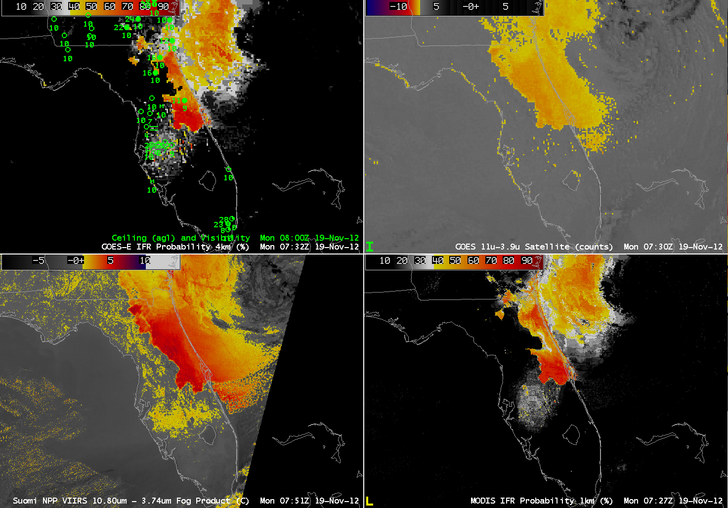 |
| GOES-R IFR Probabilities computed from GOES-East (Upper left), Traditional Brightness Temperature Difference (10.7 µm – 3.9 µm) (Upper right), Brightness Temperature Difference (10.8 µm – 3.74 µm) from Suomi/NPP data (Lower Left), GOES-R IFR Probabilities computed using MODIS data (Lower Right) |
Fog and low clouds that developed over central Florida (again) on Monday morning, 19 November, highlight some strengths and shortcomings of the different fog detection techniques. The GOES-R IFR Probability (upper right) shows highest probabilities in the region where the traditional brightness temperature difference product has a distinct signal. But there is also a region of IFR probabilities (albeit low) east of Tampa Bay where the traditional brightness temperature difference product has no distinct signal. This is likely a region of developing fog/low stratus. Note that the higher-resolution Brightness Temperature Difference product from VIIRS on Suomi/NPP has a signal in that region, and the MODIS-based IFR Probability (lower right) field is also consistent with a developing fog/low stratus field. The low IFR Probabilities in the GOES-based signal should alert to the possibility of developing fog. Note that both the GOES-Based and MODIS-based IFR probabilities show a narrower strip of fog/low stratus south of Jacksonville than is represented in the GOES and Suomi/NPP Brightness Temperature Difference fields. In this region, the Rapid Refresh Model data are refining the satellite predictors to represent more accurately the distribution of fog/low stratus in the Rapid Refresh model output. The IFR Probabilities at 1000 UTC (below) shows that IFR conditions did indeed develop in that region of interior Florida to the east of Tampa.
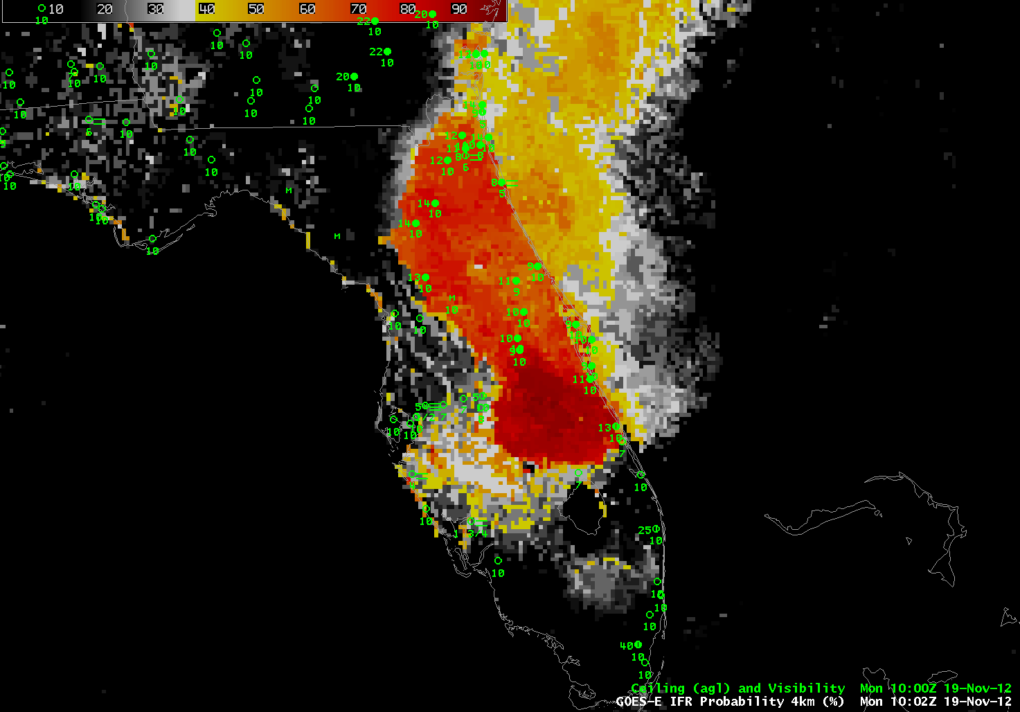 |
| GOES-R IFR Probabilities at 1002 UTC, computed from GOES-East and the Rapid Refresh Model |
The Traditional Brightness Temperature Difference field shows a signal that parallels the west-facing Gulf coasts of Florida. This signal arises from a co-registration error between the shortwave IR and longwave IR sensors on GOES (See this post for more examples). This co-registration error is diurnally varying and typically peaks between midnight and sunrise.
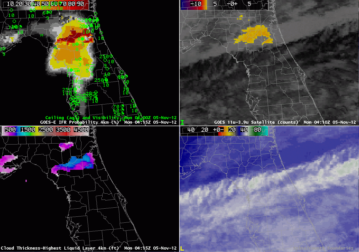 |
| GOES-R IFR Probabilities from GOES-East (Upper Right), GOES-East traditional ‘fog product’ (Brightness Temperature Difference 10.7 µm – 3.9 µm), GOES-R Cloud Thickness, GOES-East Water Vapor (6.5 µm) imagery |
Fog developed over central Florida overnight underneath a thin cirrus (as indicated by both the water vapor and brightness temperature difference imagery). Cirrus clouds prevent the traditional brightness temperature difference field from identifying low fog/stratus because the high ice clouds are detected rather than the developing low-level water clouds. This is a case, then, when a fused product gives needed surface information to help diagnose the development of fog and low stratus. The brightness temperature difference product, the traditional method to detect fog and low stratus, is giving no information where dense fog is forming.
On this date, the development and expansion of the higher IFR probabilities over central Florida neatly matches the development of IFR conditions at the observing stations. Probabilities are not high because the satellite predictors are not contributing to the algorithm. It is important when interpreting the IFR probabilities to be aware of the presence of high clouds that will influence IFR probability values. Where the cirrus clouds are not present, notably over northeast Florida, IFR probabilities are much higher because satellite predictors there are contributing to the final probability.
This case also shows that the Cloud Thickness is only computed where the highest clouds detected is a water-based cloud. Underneath the cirrus shield, except for a few regions where there are apparently holes, cloud thickness is not computed.
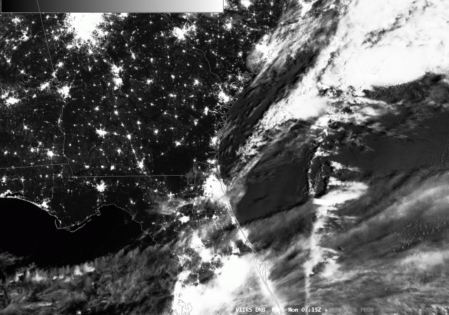 |
| GOES-R IFR Probabilities and Day/Night Band from VIIRS on Suomi/NPP, 0715 UTC 5 Nov |
The toggle above flips between the Day-Night band from VIIRS on Suomi/NPP and the GOES-R IFR probability at the same time. The thin cirrus shield is readily apparent, and the regions of fog are also visible in the Day/Night band over north-central Florida and over coastal South Carolina.
A MODIS-based IFR Probability (shown below) was also created at 0715 UTC, and it shows a pattern similar to that above. The pixelated part of the image corresponds to where satellite data are being used. The region with lower values, and a flatter field, was created using only model predictors and, as noted above, is characterized by lower probabilities. The highest probabilities are in regions where both satellite and model predictors are very confident that IFR conditions are present.
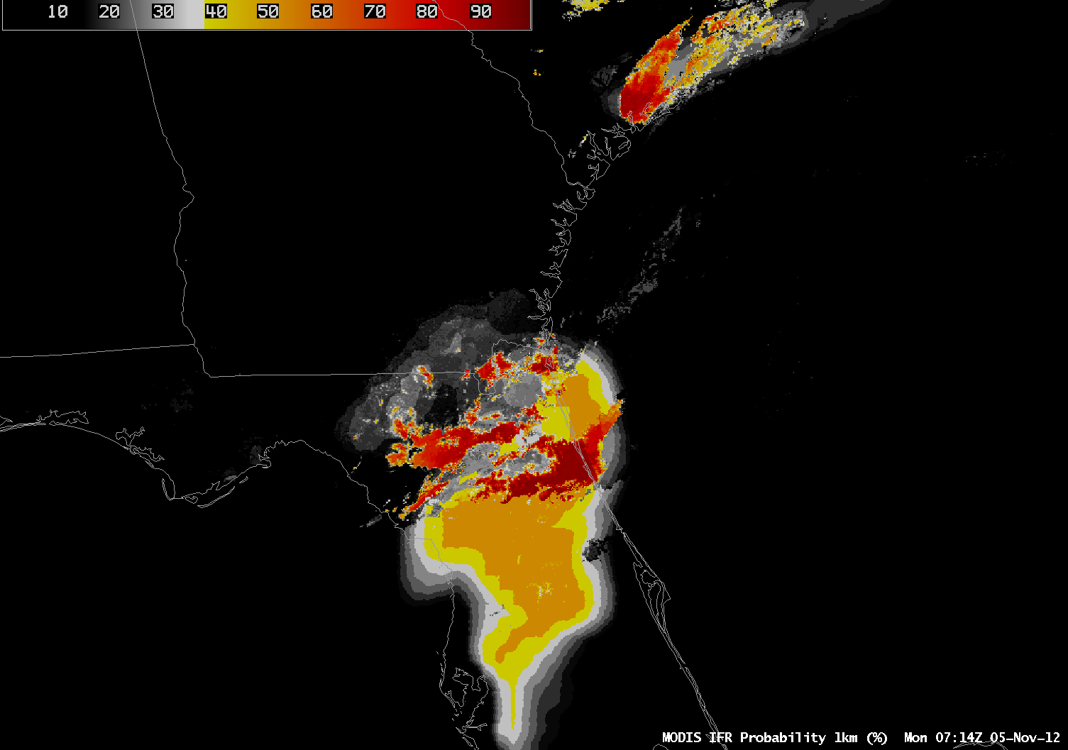 |
| MODIS-based GOES-R IFR Probabilities, Monday 5 Nov 2012, 0714 UTC |
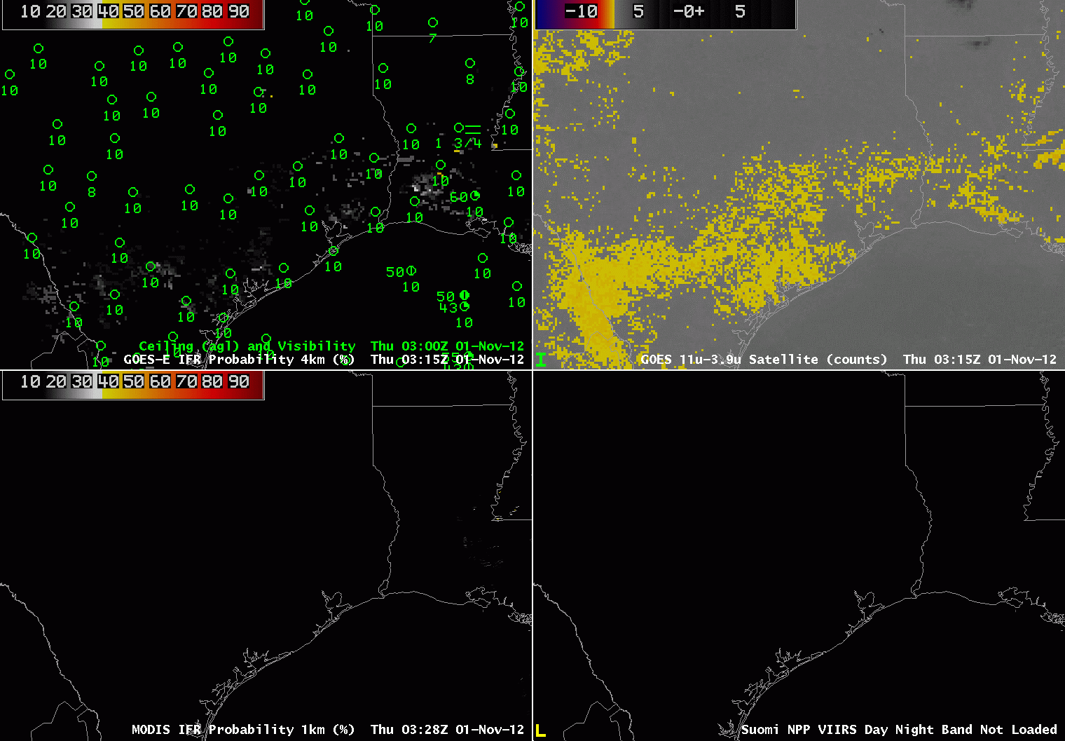
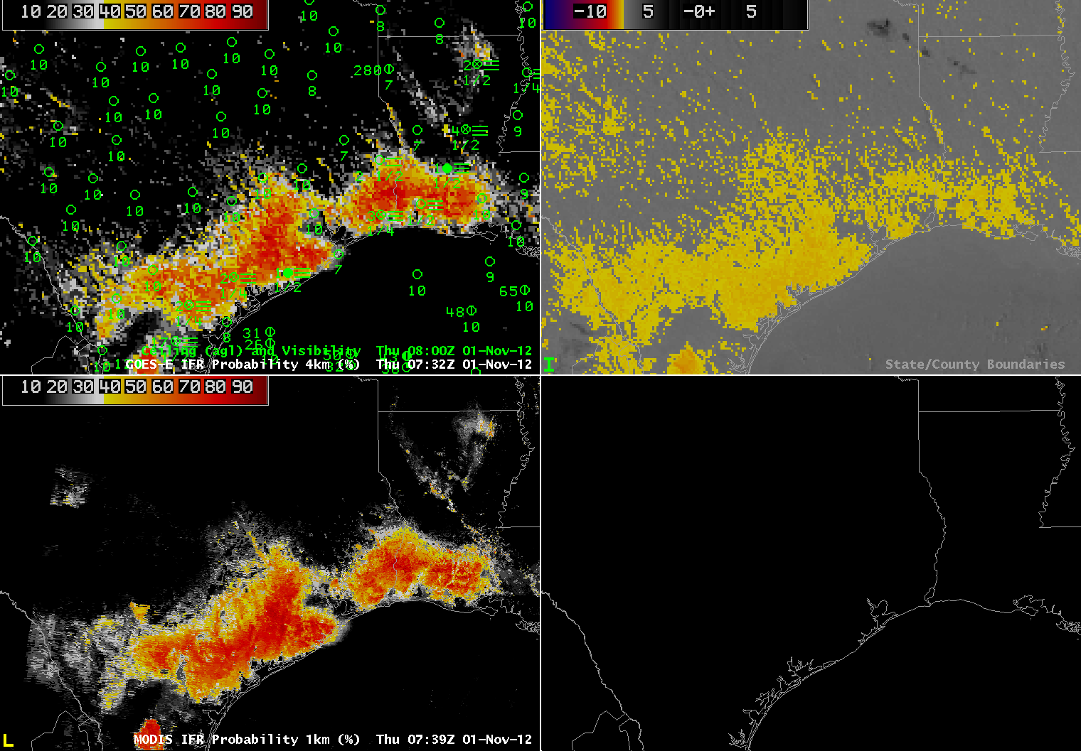
Fog was anticipated to develop over the coastal sections of Texas and Louisiana starting late on Oct 31 2012. From the 0149 UTC 1 November Houston Forecast Discussion: The 0921 UTC Forecast Discussion from Lake Charles (above) describes increasing fog possibilities — and the 0453 UTC AFD (below) mentions patchy fog.
For both WFOs, the GOES-R IFR Probability field shows a good picture of the evolving fog/low stratus as it develops.
000
FXUS64 KHGX 010149
AFDHGX

AREA FORECAST DISCUSSION
NATIONAL WEATHER SERVICE HOUSTON/GALVESTON TX
849 PM CDT WED OCT 31 2012

.DISCUSSION...
CURRENT FCST IS ON TRACK. ONLY TWEAKS TO GRIDS WERE TO MOVE UP
TIMING OF FOG FORMATION. WOULDN`T DOUBT IF A DENSE FOG ADVSY
MIGHT BE REQUIRED FOR SOME LOCATIONS...ESP SW. WILL KEEP AN EYE ON
TRENDS. DIFFUSE WIND SHIFT AND SLIGHTLY LOWER DEWPOINTS WILL
PROBABLY MOVE INTO NE ZONES LATER TONIGHT THEN STALL/WASHOUT.
000
FXUS64 KLCH 010921
AFDLCH

AREA FORECAST DISCUSSION
NATIONAL WEATHER SERVICE LAKE CHARLES LA
421 AM CDT THU NOV 1 2012

.DISCUSSION...TRAPPED LOW LEVEL MOISTURE AND CLEAR SKIES HAVE
ALLOWED AREAS OF FOG TO DEVELOP THIS MORNING ACROSS THE CWA. AT THIS
TIME PATCHY DENSE FOG HAS ALSO DEVELOPED IN CALCASIEU PARISH AND
JEFFERSON COUNTY. VISIBILITIES ARE SLOWLY DROPPING ELSEWHERE AND
IF CONDITIONS CONTINUE TO DETERIORATE A DENSE FOG ADV MAY BE NEEDED
THIS MORNING.
The 0921 UTC Forecast Discussion from Lake Charles (above) describes increasing fog possibilities — and the 0453 UTC AFD (below) mentions patchy fog.
000
FXUS64 KLCH 010453
AFDLCH

AREA FORECAST DISCUSSION
NATIONAL WEATHER SERVICE LAKE CHARLES LA
1153 PM CDT WED OCT 31 2012

.DISCUSSION...
01/06Z TAF ISSUANCE.

&&

.AVIATION...
FEW CHANGES TO THE TAFS THIS EVENING WITH WINDS NEARLY CALM ACRS
THE AREA. T/TD SPREAD NARROWING AT BPT AND LCH AND COULD SEE SOME
PATCHY FOG DEVELOP AT THESE SITES WITHIN THE NEXT HOUR OR TWO.
CANNOT RULE OUT FOG AT OTHER TAF SITES...BUT EXPECT ONSET A LITTLE
LATER AS DEWPOINT DEPRESSIONS ARE SLIGHTLY LARGER. VFR CONDITIONS
EXPECTED TO PREVAIL WITH THE EXCEPTION OF PERIODIC MVFR OR BRIEF
IFR VISBYS BETWEEN NOW AND 14Z. LT WINDS WILL GRADUALLY BECOME
SWLY THURS AFTN. 24
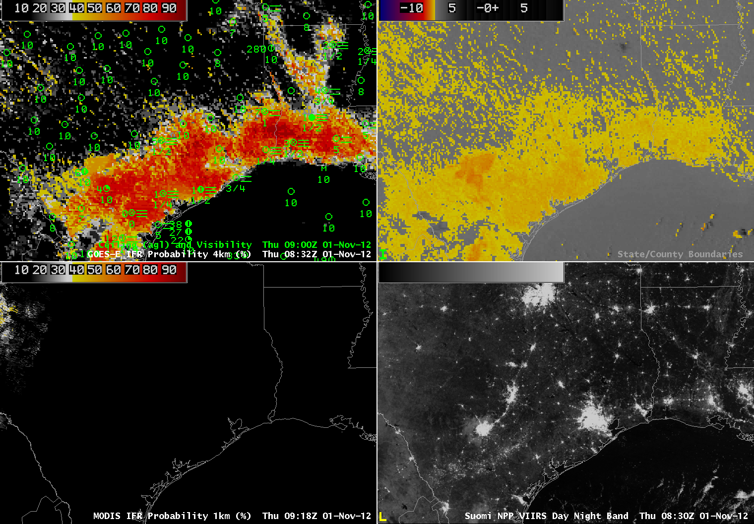
For both WFOs, the GOES-R IFR Probability field shows a good picture of the evolving fog/low stratus as it develops. The every-hour loop below, starting at 0315 UTC, shows the steady increase in probabilities along the Louisiana and Texas Gulf Coasts. Note the relatively low probabilities in and around Houston — an apparent break between IFR conditions to the north and east and those to the south. The Houston airport observations did not fall to IFR criteria although those criteria were common to the north and south. Also, the IFR probabilities downplay the brightness temperature difference signal over central Texas where IFR conditions do not occur.
 |
| GOES-R IFR Probabilities computed from GOES-East (upper left), Traditional Brightness temperature Difference product (10.7 µm – 3.9 µm) (upper right), GOES-R IFR Probabilities computed from MODIS (lower left), Suomi/NPP Day/Night Band (lower left) |
The imagery below shows GOES-R and MODIS imagery at the same time (immediately below) and GOES-R and Suomi/NPP imagery at the same time (bottom). Note that the fog that develops is not of sufficient thickness to block views of the city lights.
 |
|
| GOES-R IFR Probabilities computed from GOES-East (upper left), Traditional Brightness temperature Difference product (10.7 µm – 3.9 µm) (upper right), GOES-R IFR Probabilities computed from MODIS (lower left), Suomi/NPP Day/Night Band (lower left) |
 |
| GOES-R IFR Probabilities computed from GOES-East (upper left), Traditional Brightness temperature Difference product (10.7 µm- 3.9 µm) (upper right), GOES-R IFR Probabilities computed from MODIS (lower left), Suomi/NPP Day/Night Band (lower left) |
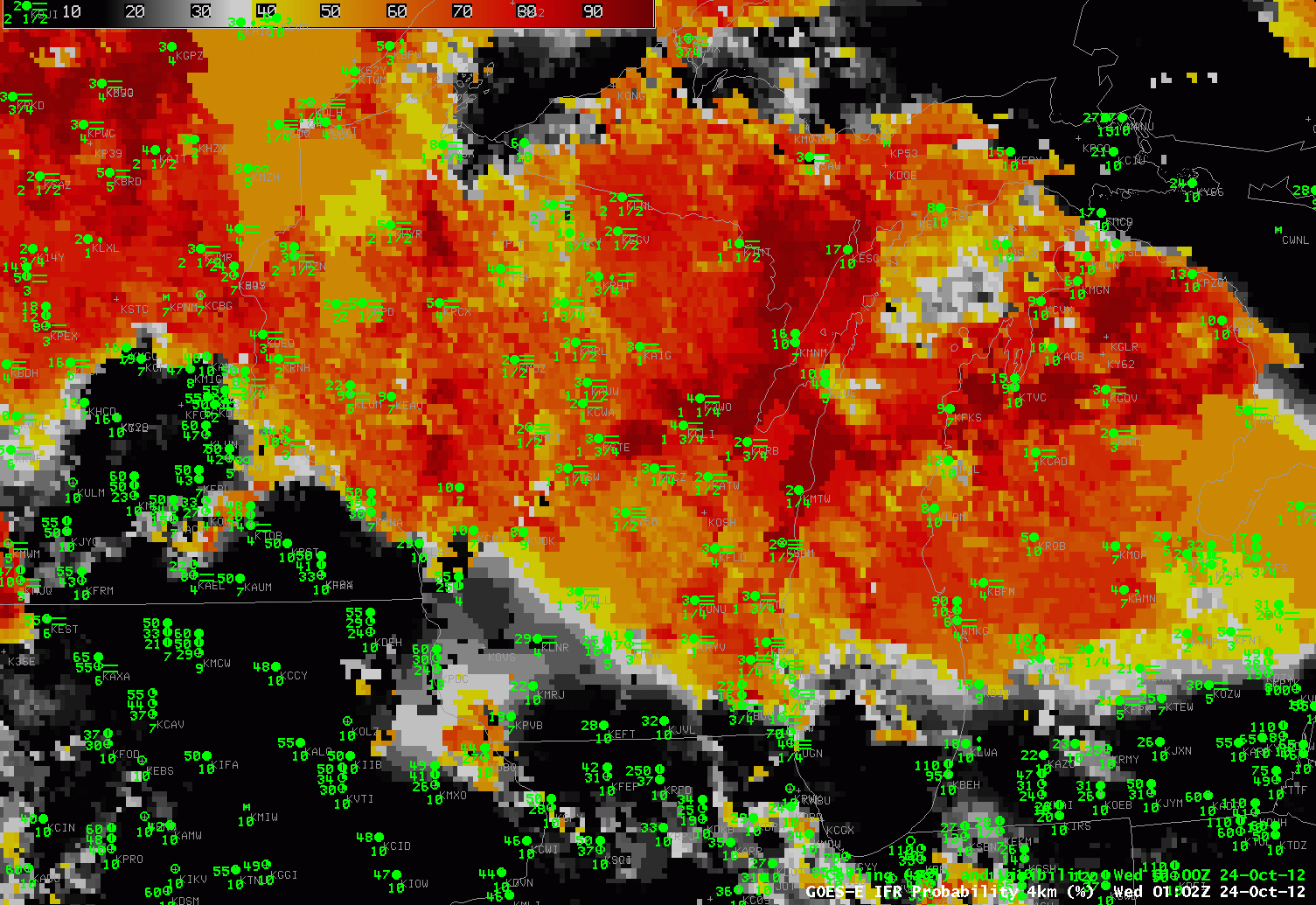 |
| GOES-R IFR Probabilities at 0100, 0400 and 0800 UTC on 24 October 2012 |
Dewpoints in the low 60s (Fahrenheit) surging into the upper Midwest in late October heighten the chances of fog, and the GOES-R Fog/Low Stratus product did a commendable job of showing where the fog might be occurring. The loop above shows the IFR Probabilities over Wisconsin, Iowa and Minnesota as well as visibility/ceiling observations. The northwest-southeast edge of higher probabilities over southern to west-central Wisconsin at 0100 UTC matches the observations well: IFR conditions prevail in regions north and east of that line. Note also, at 0400 UTC, the skinny region of enhanced IFR probabilities that hugs the western shore of Lake Michigan. Lake Michigan lake surface temperatures are in the low 40s, so dewpoints above 50 will result in a dense advection fog. Heightened probabilities continue at 0800 UTC over northern and eastern Wisconsin, in agreement with observations.
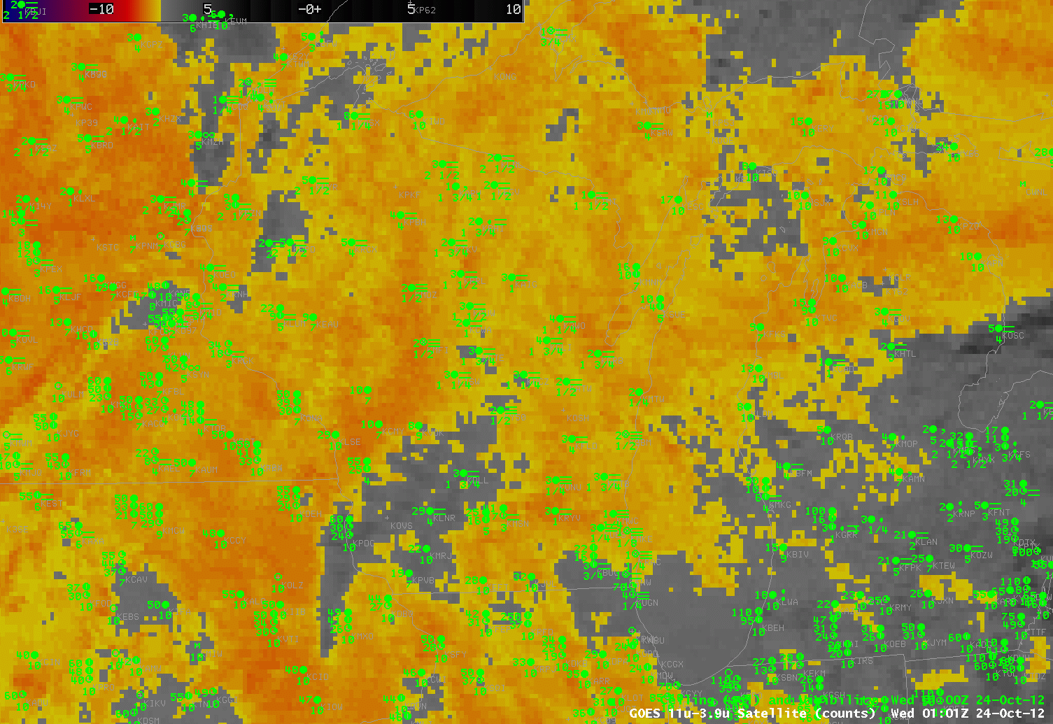 |
| Heritage Fog Detection, brightness temperature difference, at 0100, 0400 and 0800 UTC on 24 October |
The Brightness temperature difference field historically has been used to diagnose the presence of low clouds, and the animation above shows the importance of using fused products — that include some kind of influence from surface observations as occurs in the Rapid Refresh — to clarify exactly where the low clouds that obstruct visibility are common. Consider the field at 0100 UTC. The IFR probability delineates between higher visibility over southern/western Wisconsin and lower visibilities north and east. No such delineation occurs in the tradiational product because the brightness temperature difference alone cannot indicate the ceiling.
MODIS data is also used to create IFR Probability fields, and the 0417 UTC imagery is shown below.
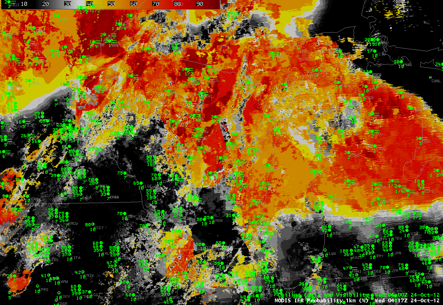 |
| MODIS-based GOES-R IFR Probabilities, 0417 UTC 24 October. |
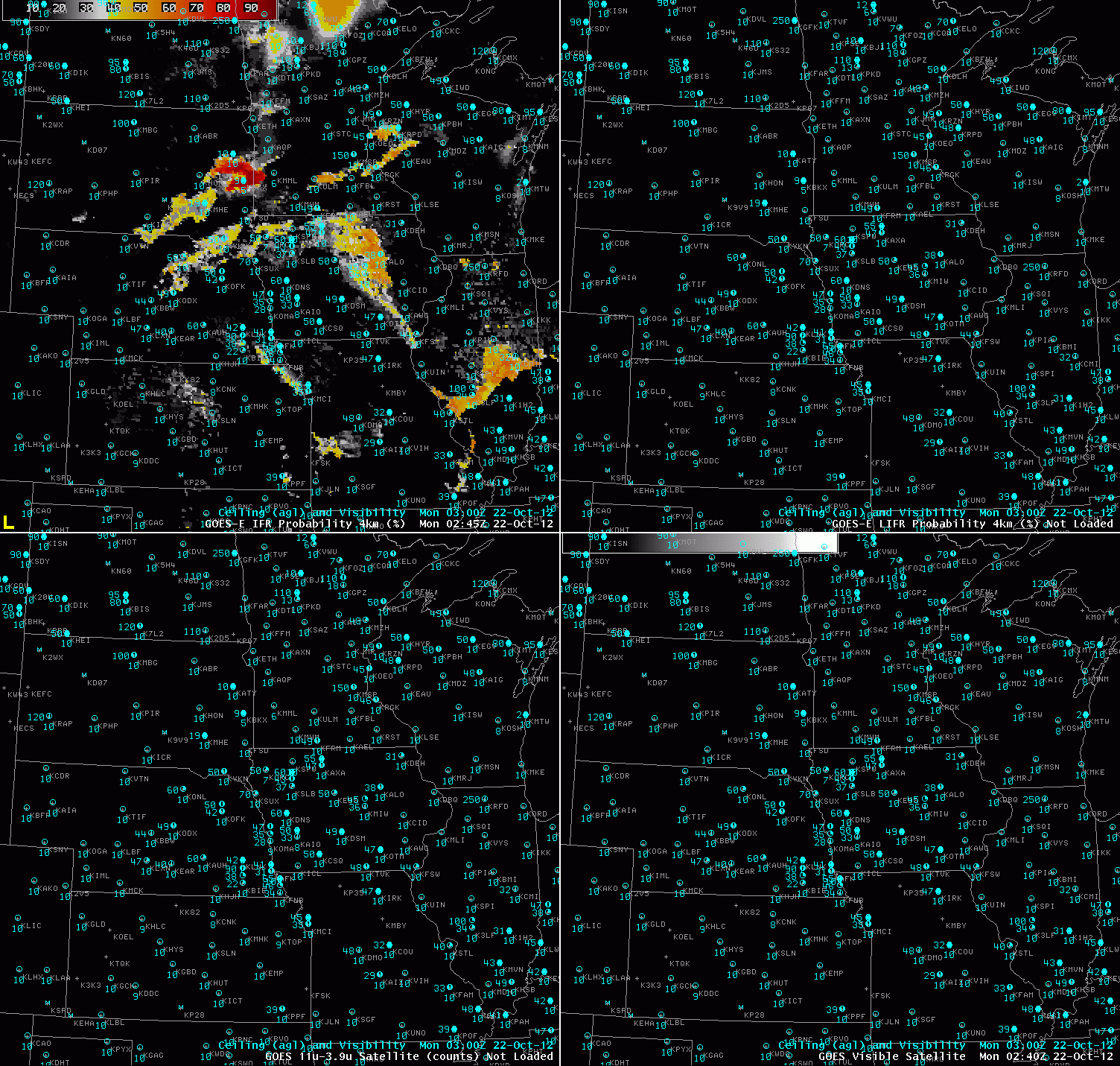 |
| GOES-R IFR probabilities (upper left), GOES-R LIFR probabilities (upper right), GOES-13 brightness temperature difference (3.9-11 µm) (lower left) and visible satellite image (lower right). Surface observations of visibility and cloud ceiling (above ground level) are overlaid on all 4 panels in blue |
The GOES-R IFR probabilities are useful when monitoring the formation of fog and/or low stratus (FLS) clouds. In this case over the Upper Midwest U.S. FLS started forming over eastern South Dakota and quickly spread to adjacent states eventually becoming widespread over most of the Upper Midwest. Surface observations of IFR conditions correlate very well to the areas of high IFR probabilities denoted by the dark orange to red colors. In the animation above the GOES-R IFR probabilities track the formation of the FLS with high confidence, evidenced by the relatively high IFR probabilities. The traditionally-used 3.9-11 micron BTD product also detects the FLS, but has difficulty detecting the spatial extent of the hazardous areas of the cloud deck. During the initial formation before 10Z Surface observations over Iowa and S. Minnesota indicate that elevated clouds are present, but they do not meet the IFR criteria for surface visibility (< 3 miles) and/or cloud ceiling (<1000 ft) until after a cluster of showers and thunderstorms passes through. This cluster of showers and storms can be seen in the 3.9-11 micron BTD as the gray and black circular area moving east over Iowa. In these types of situations the satellite only approach does not provide any information on what's going on near the surface because the satellite can only view the top most cloud layer. Using a blended approach merging satellite information with modeled forecast data from the Rapid Refresh model the IFR probabilities can still provide useful information on the presence of hazardous low cloud conditions even when multiple cloud layers are present.
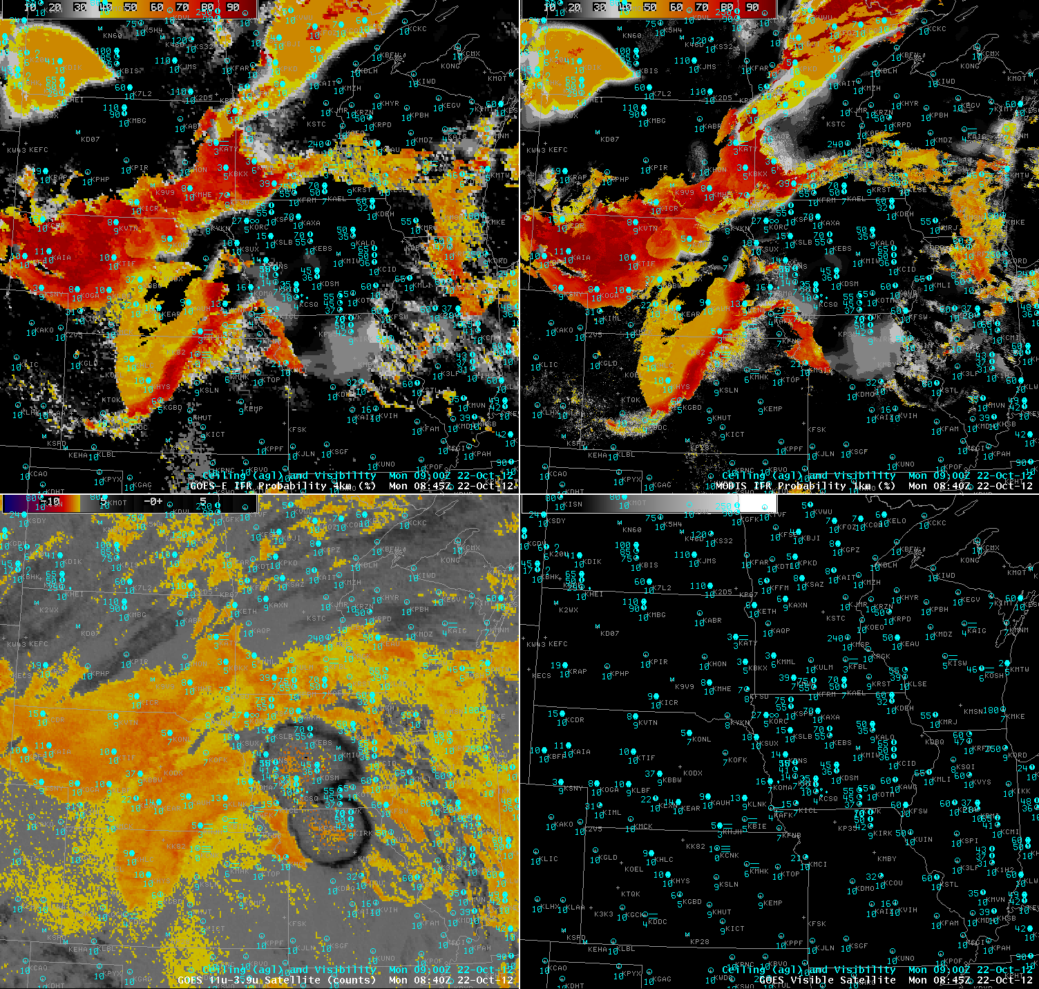 |
| GOES-R IFR probabilities applied to MODIS (upper left), GOES-R LIFR probabilities applied to MODIS (upper right), MODIS brightness temperature difference (3.9-11 µm) (lower left) and visible satellite image (lower right). Surface observations of visibility and cloud ceiling (above ground level) are overlaid on all 4 panels in blue |