Monthly Archives: February 2017

Dense fog in Ohio, Indiana and Illinois

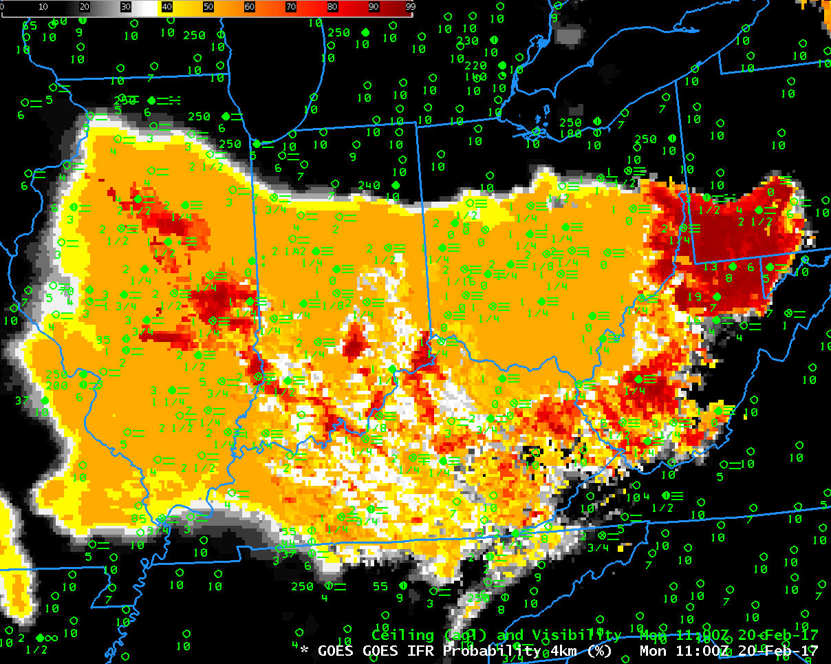
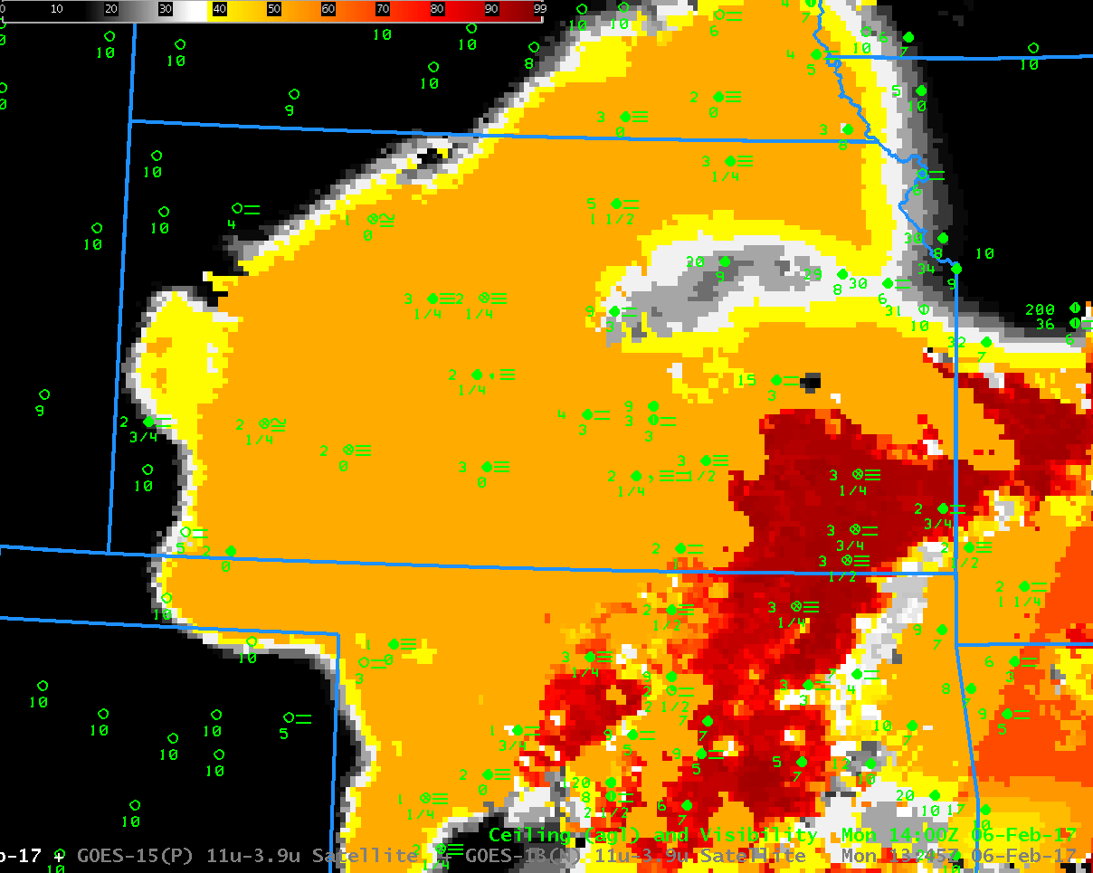
Toggle between 1100 UTC GOES-R IFR Probability fields and GOES-13 Brightness Temperature Difference (3.9 µm – 10.7 µm) fields, with surface observations of ceilings and observations. (Click to enlarge)

Dense Fog developed over central/southern Ohio, Indiana and Illinois on the morning of 20 February 2017 (Screen shot from here; IFR Depiction from here). The toggle above includes the GOES-R IFR Probability fields; large values of IFR Probability overspread the region of low ceilings and visibilities. In contrast, high clouds (dark grey in the enhancement used) are preventing the Brightness Temperature Difference field from articulating where the fog/low ceilings might be occurring. Because satellite data cannot be used as a predictor at 1100 UTC, the character of the IFR Probability field is mostly uniform, lacking the pixelation that occurs when low clouds can be viewed from the satellite (as over southwestern Pennsylvania, West Virginia, central Kentucky, parts of central Illinois, and elsewhere).

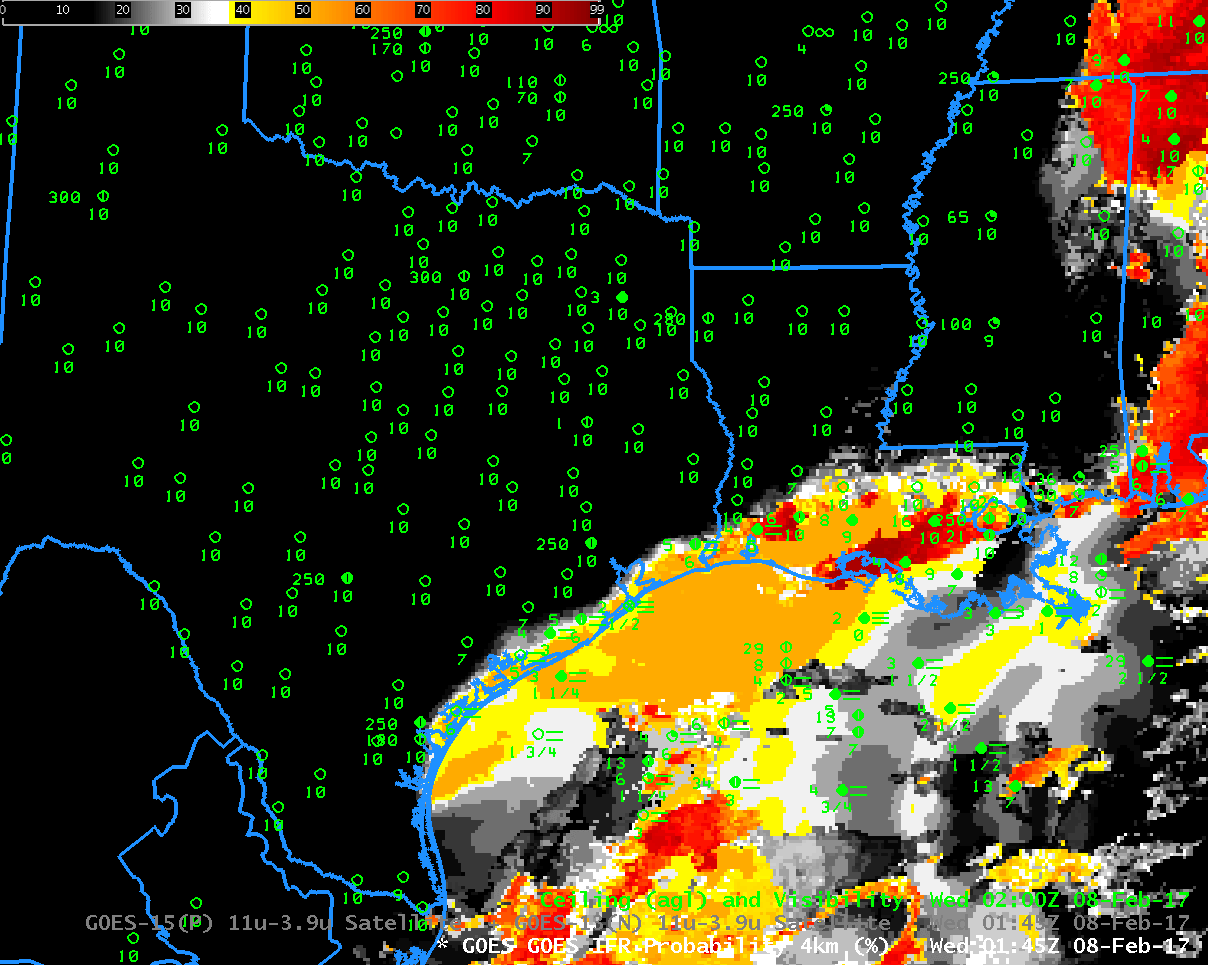
High clouds have not moved into Ohio and Indiana at 0500 UTC on 20 February as the fog was developing (they are present over Illinois, however). The toggle below, from that time, shows low probabilities of IFR conditions over Ohio, and only a few reports of IFR conditions, mostly over central and southern Ohio.

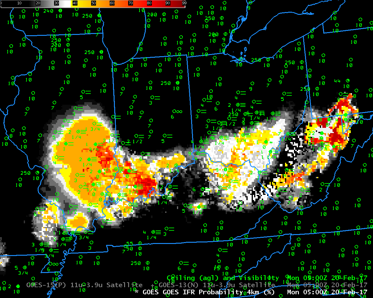
Toggle between 0500 UTC GOES-R IFR Probability fields and GOES-13 Brightness Temperature Difference (3.9 µm – 10.7 µm) fields, with surface observations of ceilings and observations. (Click to enlarge)

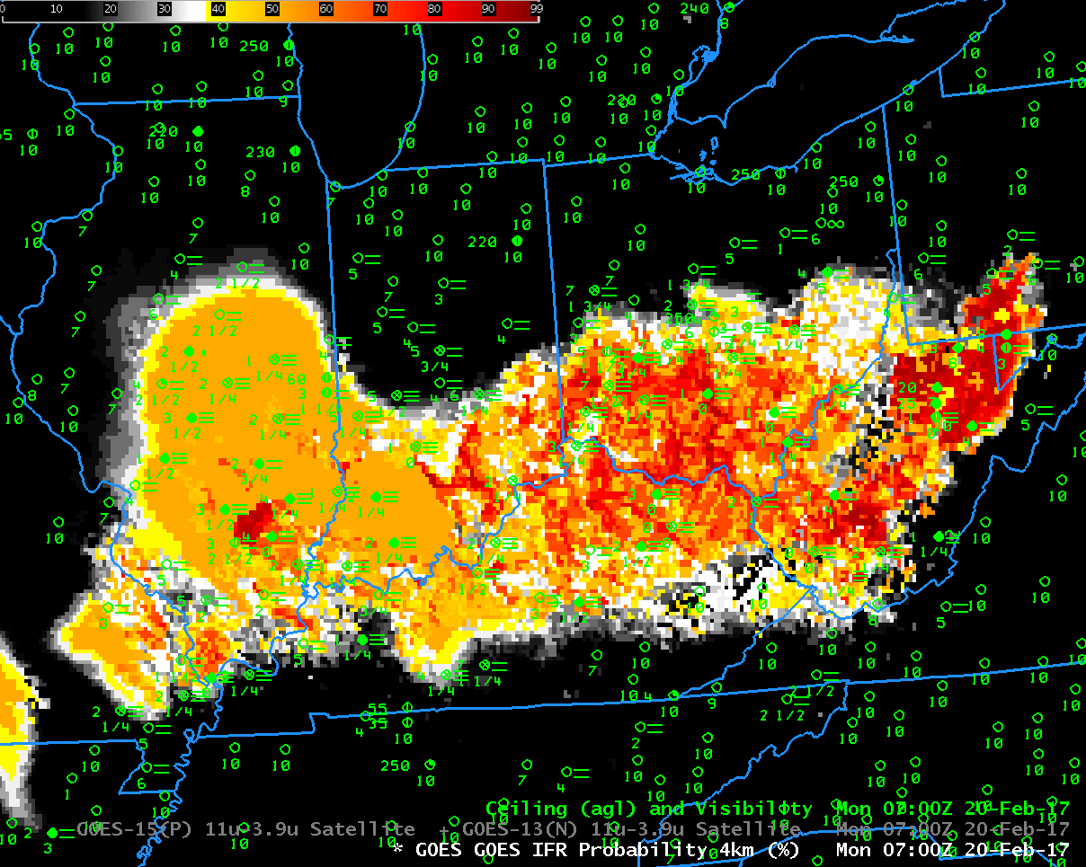
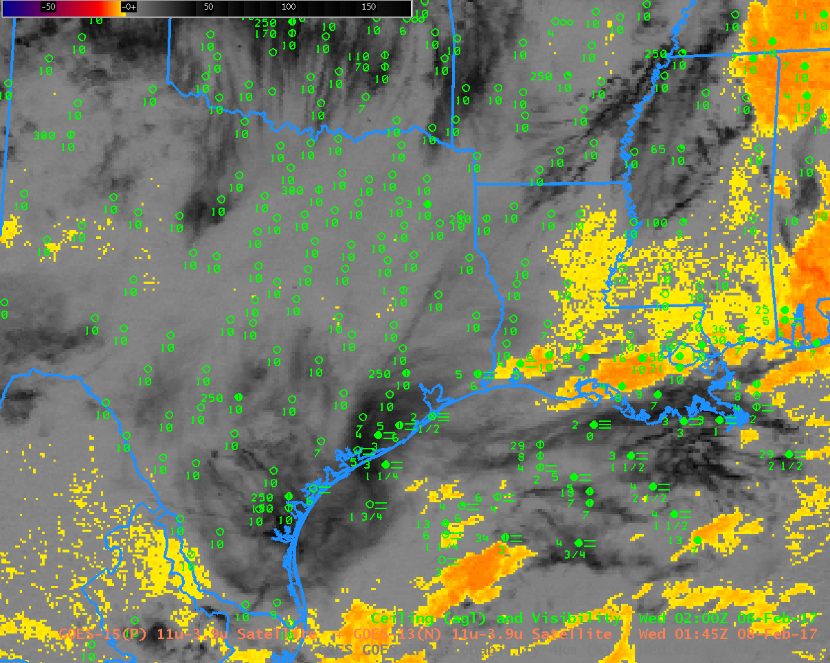
Toggle between 0700 UTC GOES-R IFR Probability fields and GOES-13 Brightness Temperature Difference (3.9 µm – 10.7 µm) fields, with surface observations of ceilings and observations. (Click to enlarge)

By 0700 UTC (above), IFR conditions are becoming more widespread as IFR Probabilities increase.  The dark regions in the Brightness Temperature Difference fields over Wisconsin and Lower Michigan and surrounding regions show the advance of high clouds.  By 1000 UTC, those clouds have overspread Ohio and Indiana, and the brightness temperature difference field loses utility as far as low-cloud detection goes.  Because the IFR Probability fields incorporate low-level saturation information from the Rapid Refresh Model, however, IFR Probability fields can continue to provide a useful signal when high clouds are present or move in.

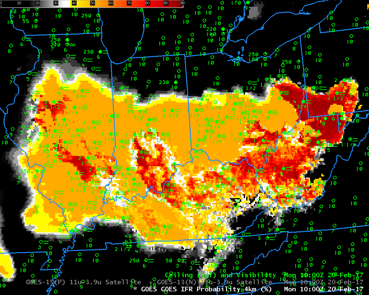
Toggle between 1000 UTC GOES-R IFR Probability fields and GOES-13 Brightness Temperature Difference (3.9 µm – 10.7 µm) fields, with surface observations of ceilings and observations. (Click to enlarge)

IFR Conditions over Maine

GOES-R IFR Probability and with surface observations of ceilings and visibilities, 1045 UTC on 13 February 2017 (Click to enlarge)

A strong storm off the East Coast of the United States produced a variety of winter weather over Maine on 13 February 2017, including Blizzard conditions. Although ceilings and visibilities above show IFR or near-IFR conditions at 1045 UTC, GOES-R IFR probabilities over Maine are small (less than 20%). Why?

The image below from this site shows Cloud Type, Low-Level Saturation, IFR Probability, and the Nighttime Microphysics.  Both Ice clouds and falling snow are widespread over Maine. GOES-R IFR Probabilities typically assume saturation with respect to water.   The Gray, ME morning sounding shows maximum RH (with respect to water) at only 94% (Link).  Assuming saturation with respect to water rather than with respect to ice may be a source of error that will have to be investigated in the future.

Note that after sunrise, IFR Probabilities increased over Maine to values between 30 and 45% (Link).

Satellite-derived Cloud Type (upper left), Maximum Low-Level Relative Humidity in the Rapid Refresh (upper right), GOES-R IFR Probability (lower left) and Nighttime microphysics (lower right), all from 1045 UTC on 13 February (Click to enlarge)

Dense Fog Advisories along the western Gulf Coast

GOES-R IFR Probability fields, hourly from 0145-1345 UTC on 08 February 2017, along with surface observations of visibility and ceiling height (Click to enlarge)

Dense Fog developed along the western Gulf Coast early on the morning of 8 February 2017, leading to the issuance of Dense Fog Advisories (graphic from this site) and of IFR Conditions (graphic from this site).  The animation above shows the expansion of the field of high IFR Probabilities northwestward from the Gulf of Mexico starting at 0145 UTC.  IFR Conditions reported in concert with the arrival of higher IFR probabilities.  Relatively high IFR Probability values also develop over northern MIssissippi and Alabama.

The traditional method of detecting low clouds at night, the brightness temperature difference field computed using brightness temperatures at 3.9 µm and 10.7 µm detects water-based clouds because of the different emissivity properties of the water-based cloud at those two wavelengths.  If ice clouds (at high levels) or mixed phase clouds (at mid-levels) exist, however, the satellite cannot view the low clouds.  This was the case on 8 February over northern Mississippi and northern Alabama, and also occasionally over Louisiana and Texas.  The toggle below from 0945 UTC, between the GOES-R IFR Probability field and the Brightness Temperature Difference field, shows several regions where Brightness Temperature Difference field enhancements do not indicate low clouds (over northwestern Mississippi, for example); in these regions, IFR Probabilities are nevertheless large because Rapid Refresh model data shows saturation in the lowest 1000 feet of the atmosphere, strongly suggestive of high IFR Probabilities, and that predictor serves to increase the value of the IFR Probability. The animation of the Brightness Temperature Difference fields is at the bottom of this blog post; compare it to the IFR Probability fields at the top. The IFR Probability algorithm capably fills in regions under high clouds/mid-level clouds where the satellite cannot view low clouds.  It gives a more consistent (and more accurate) depiction of the spread of the low clouds/fog.

Brightness Temperature Difference (3.9 µm – 10.7 µm) and GOES-R IFR probability at 0945 UTC on 8 February 2017 (Click to enlarge)

Another difficulty with Brightness Temperature Difference fields occurs around sunrise when increasing amounts of reflected solar radiation at 3.9 µm cause a sign change in the brightness temperature difference field (reflected 3.9 µm radiation increases as the sun rises and the computed brightness temperature therefore changes because reflected solar radiation at 10.7 µm is minimal;  emissivity-related differences between the two bands are overwhelmed).  The toggle below compares 1245 UTC and 1345 UTC Brightness Temperature Values.

Brightness Temperature Difference (3.9 µm – 10.7 µm) at 1245 and 1345 UTC on 8 February 2017 (Click to enlarge). Decreases in the brightness temperature differences occur at 1345 UTC because of increases in reflected solar radiation at 3.9 µm.

Brightness Temperature Difference (3.9 µm – 10.7 µm), 0145 – 1345 UTC on 8 February 2017, along with surface observations of ceilings and visibility (Click to enlarge)

Fog over Kansas

GOES-R IFR Probability fields, 1345 UTC on 6 February 2017, along with 1400 UTC surface observations of ceilings and visibilities (Click to enlarge)

Dense Fog Advisories were issued for much of central Kansas early on 6 February 2017.  This was an example of how GOES-R IFR Probability fields (above) can help identify regions of dense fog when high clouds prevent satellite detection of low clouds.  The brightness temperature difference field, below, shows high clouds over much of Kansas — it’s therefore very difficult to relate cloud signatures to obstructions to visibility near the surface.  In contrast, IFR Probability fields, above, use saturation in the lowest part of the Rapid Refresh Model and capably highlight regions where fog/low ceilings are occurring.

Brightness Temperature DIfference field (3.9µm – 10.7µm) at 1345 UTC on 6 February 2017, along with surface observations of ceilings and visibility (Click to enlarge)