Category Archives: Aviation

IFR Probability near a major aviation hub

GOES-16 IFR Probability, 0926 – 1101 UTC on 12 October 2020 (Click to enlarge)

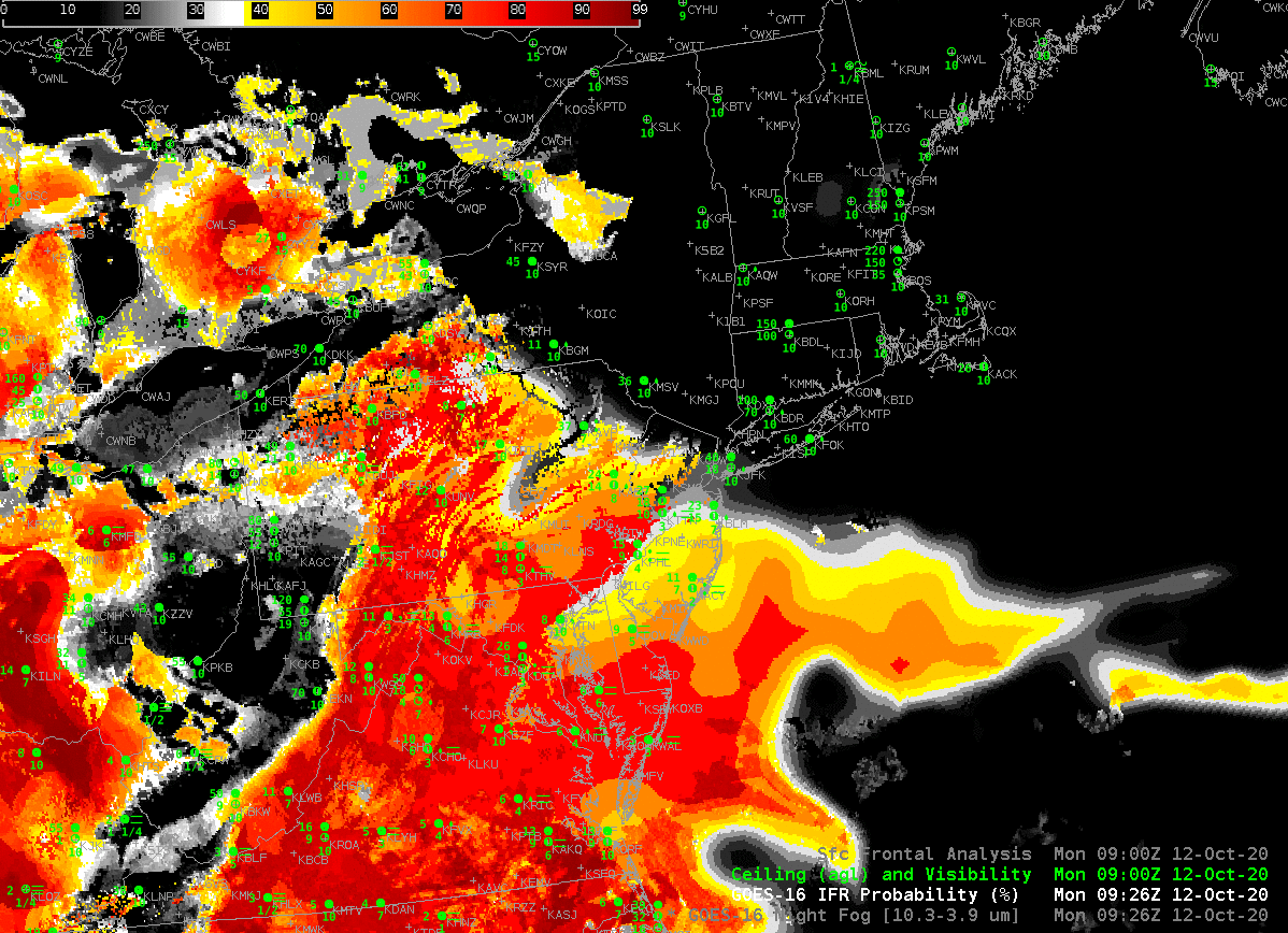
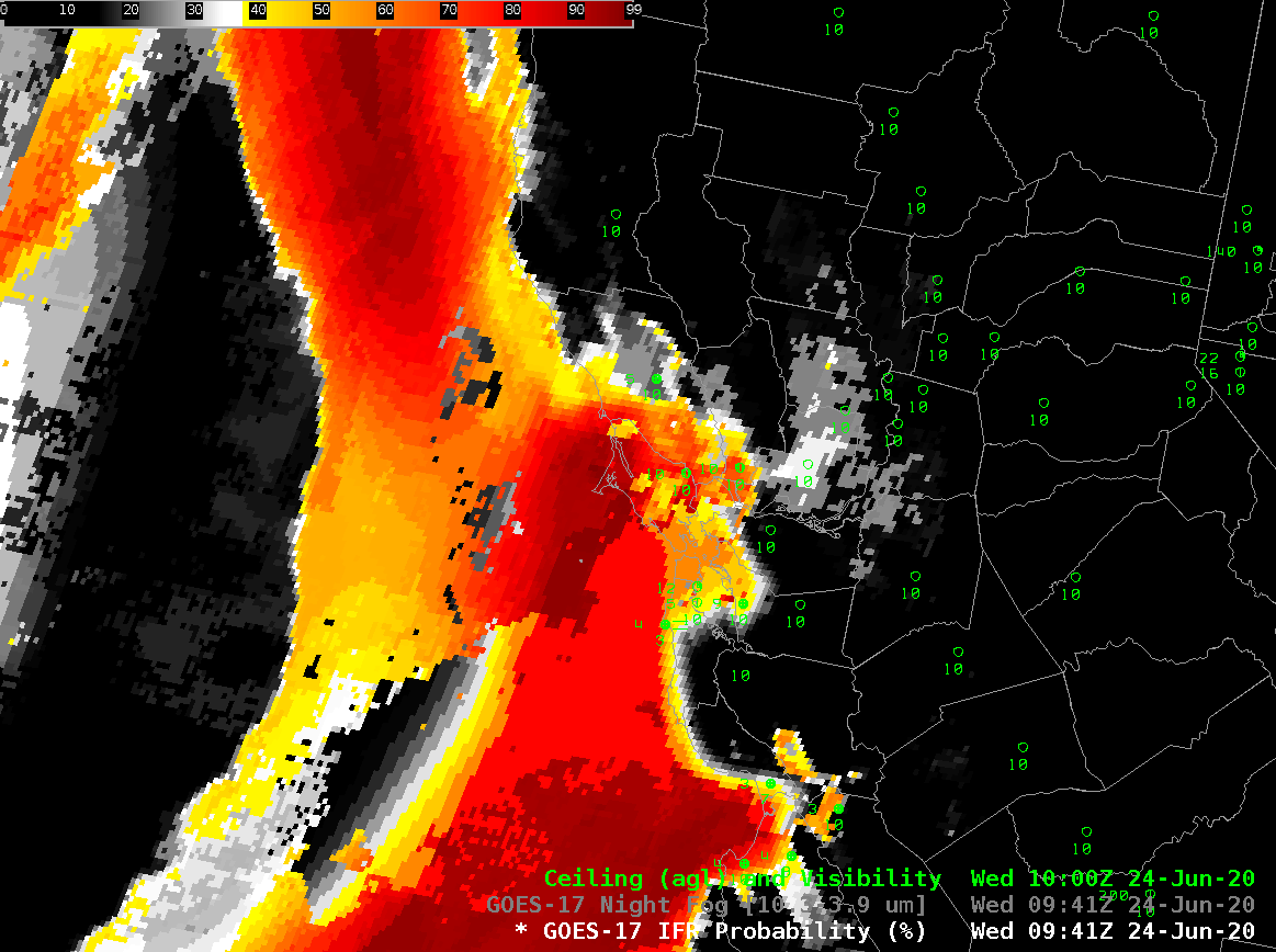
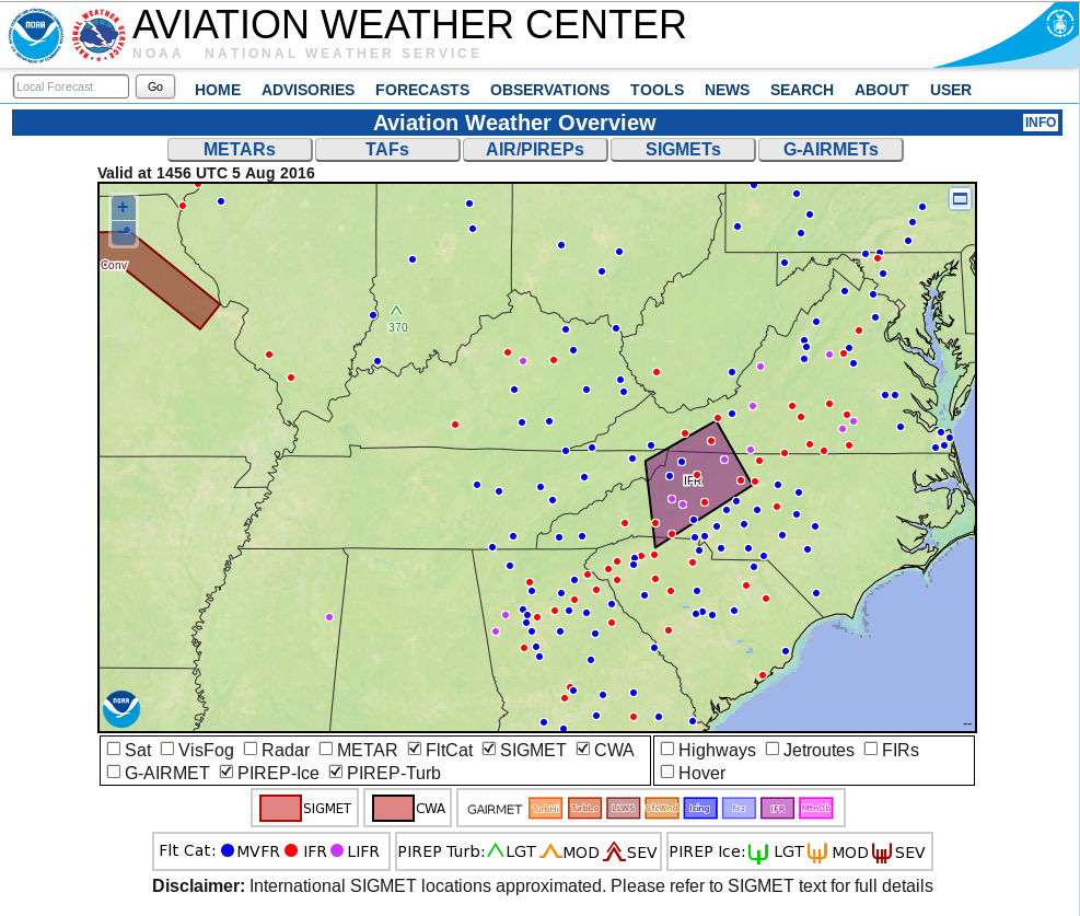
The New York City area has 3 major international hubs for which ceiling/visibility observations and prediction are critical to efficient operations. IFR Probability fields use both satellite data and Rapid Refresh model data and can supply information about low-level conditions even where mid-level or upper-level clouds obscure a satellite’s view of low clouds. The example above shows very slow northeastward progress of an area of potential IFR conditions towards New York.

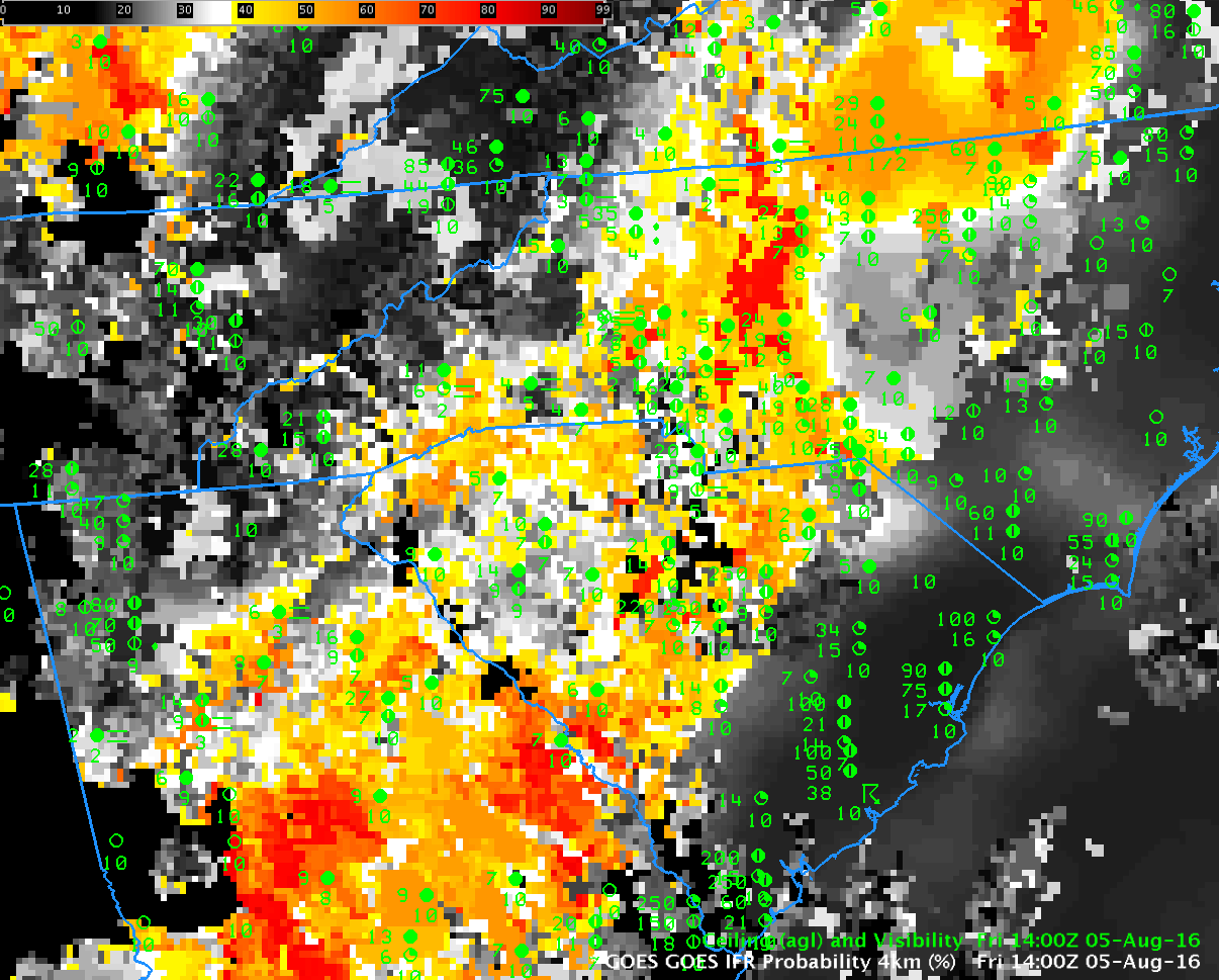
Satellite-only data, below, in the form of the night fog brightness tempreature difference from GOES-16, does not give a useful signal for the low clouds along the east coast. A conclusion: Use IFR Probability to monitor the progress of low clouds when multiple cloud decks are present.

GOES-16 ‘Night Fog’ Brightness Temperature Difference (10.3 µm – 3.9 µm) field, 1006-1101 UTC, 12 October 2020 with 0900 UTC frontal analysis overlain on first image (Click to enlarge)
GOES-16 IFR Probability and GOES-16 ‘Night Fog’ Brightness Temperature Difference (10.3 µm – 3.9 µm) field, 1101 UTC, 12 October 2020 (Click to enlarge)

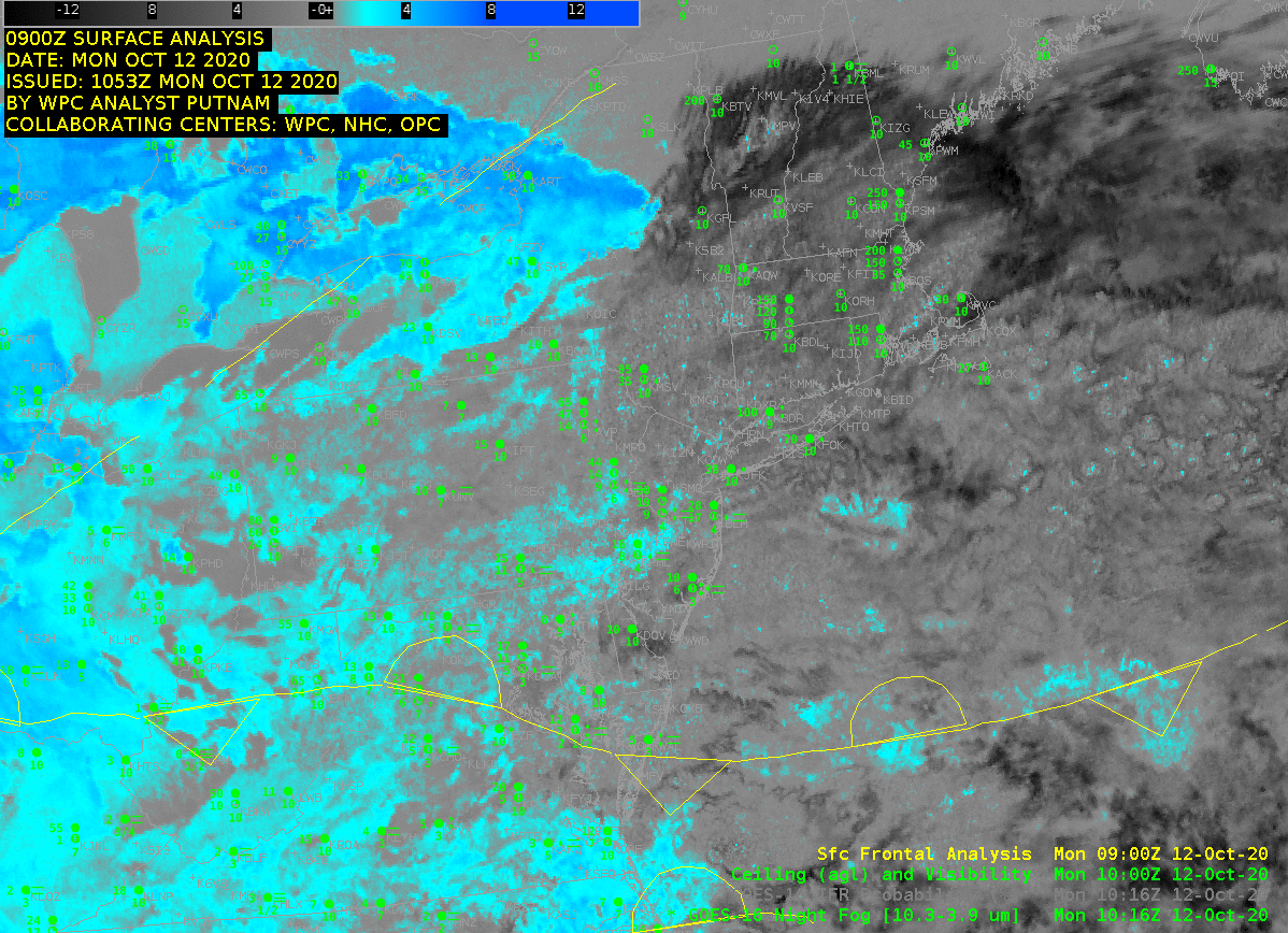
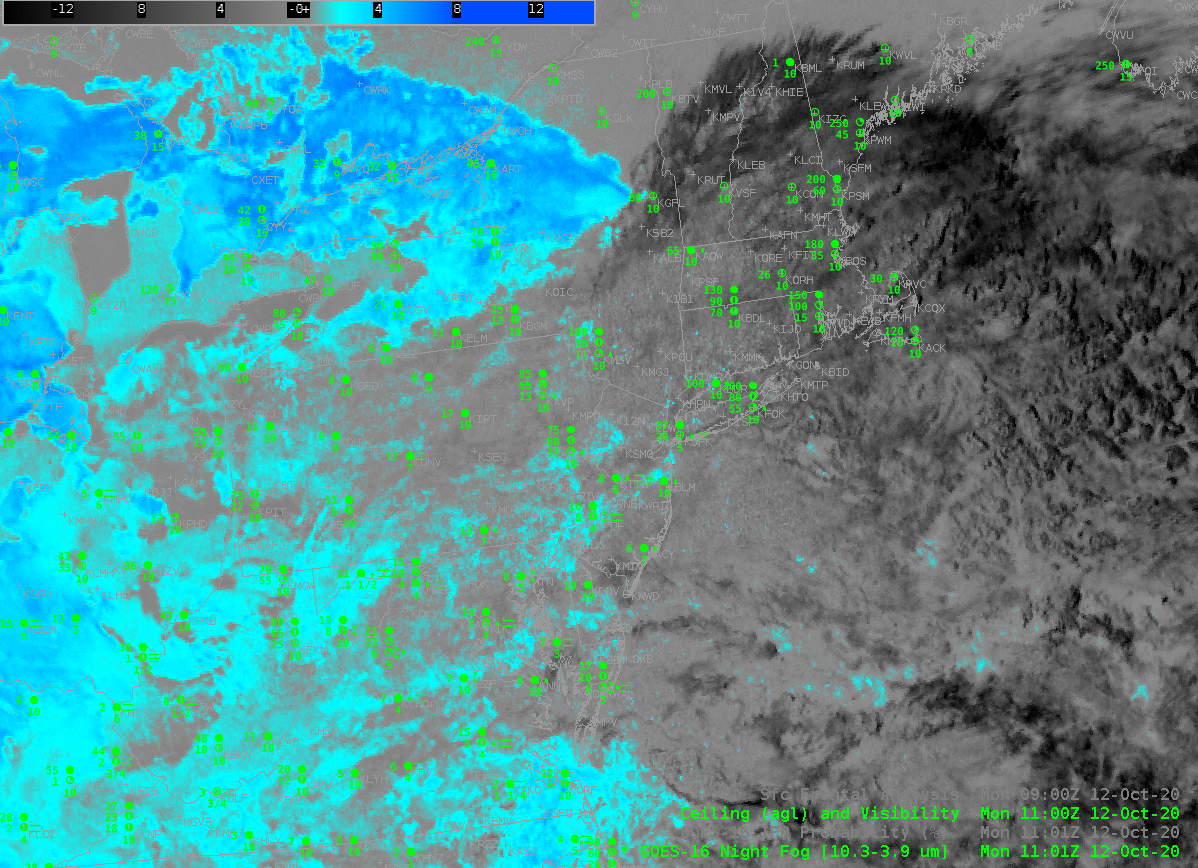
The toggle above, between IFR Probability and the Brightness Temperature Difference demonstrates and underscores (1) how IFR Probability can fill in regions under low clouds (in Delmarva and New Jersey, for example), and screen out regions with mid-level stratus (over eastern Lake Ontario the surrounding land, and over eastern Ohio, for example).

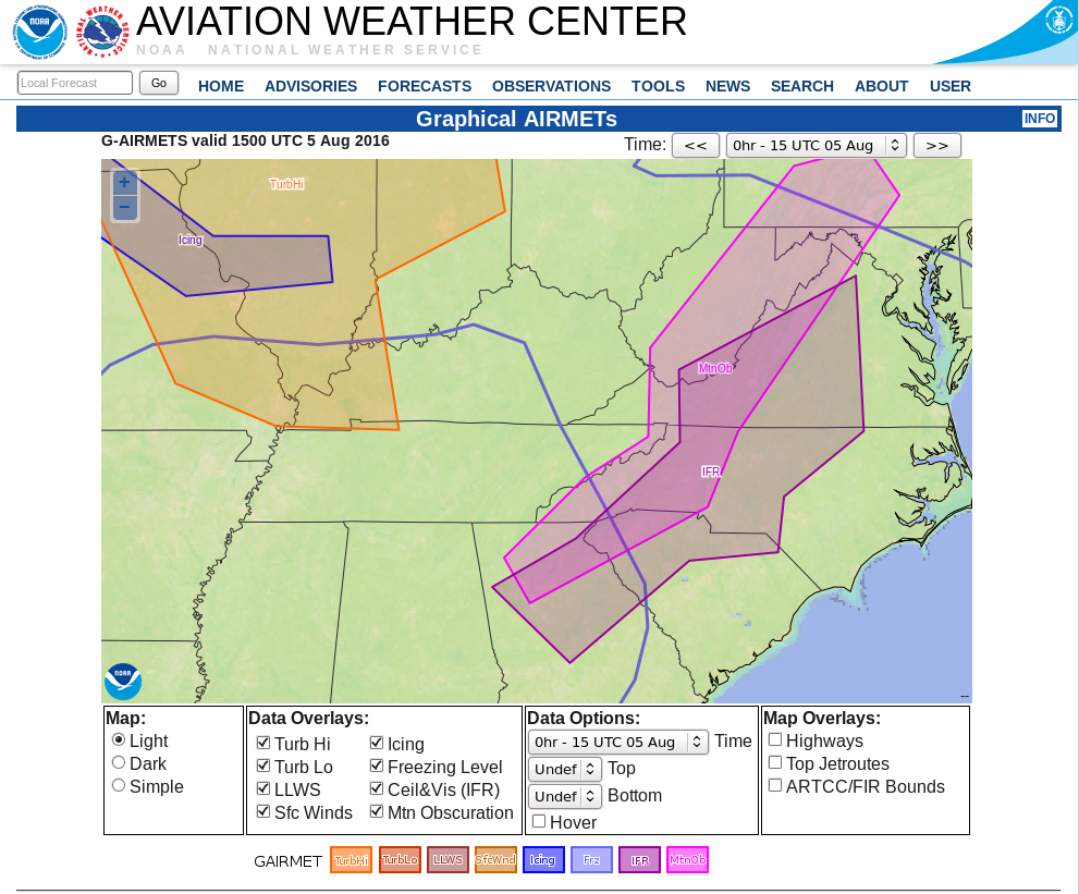
IFR Probability fields are supplied to AWIPS (TOWR-S Build 19) via the SBN.

Assessing IFR probabilties in regions with multiple cloud layers: San Francisco on 24 June 2020

GOES-17 ‘Night Fog’ Brightness Temperature Difference (10.3 µm – 3.9 µm) 0941 UTC – 1436 UTC, 24 June 2020 (Click to enlarge)

GOES-17 ‘Night Fog’ Brightness Temperature Difference imagery, above, shows a stratus deck (cyan and blue in this default AWIPS enhancement) off the central California coast. Higher clouds (grey and black in the enhancement) are drifting over San Francisco bay, obscuring the GOES-17 satellite’s view of low clouds. These high clouds can present a challenge to aviation forecasters for San Francisco’s airport, and important airline hub because the nature of low clouds cannot be determined. (Note the striping in the image is an artifact of GOES-17’s malfunctioning Loop Heat Pipe). This animation also shows the effect of increasing amounts of reflected solar radiation on the Night Fog Brightness Temperature Difference signal.

GOES-17 IFR Probability fields, below, augment information at low levels by using model (Rapid Refresh) estimates of low-level saturation (as might be found in low stratus) in the computation of IFR Probability. The animation below shows that SFO was in a region of high — but not very high — IFR Probabililty. Note also how the signal is constant through the sunrise at the end of the animation.

The airport (KSFO) did not report IFR conditions on this morning.

GOES-17 IFR Probability fields, 0941 – 1436 UTC, 24 June 2020 (Click to enlarge)

Fog over northeast Colorado backs into Denver International

GOES_R_IFRP_31August2016-50

GOES-R IFR Probability Fields, 1437 UTC on 31 August 2016, with surface observations of ceilings and visibilities (Click to enlarge)

GOES-R IFR Probability Fields over Colorado and Nebraska on the morning of 31 August 2016 show high IFR Probabilities in close proximity to Denver International Airport (DIA), which airport was reporting IFR conditions starting at 1237 UTC. Webcams to the southwest and northeast of the airport shortly after 1500 UTC confirm that the IFR conditions’ edge was very near the airport.

The hourly animation of GOES-R IFR Probability fields, below, shows the evolution of the field. Its motion could be used in a prognostic manner.

GOES_R_IFRP_31August2016anim_0400_1400

GOES-R IFR Probability fields, ~hourly from 0400 through 1400 UTC on 31 August 2016 (Click to enlarge). Surface observations of ceilings and visibility are also plotted.

A similar event occurred on 22 September, see below from Mike Eckert and Amanda Terborg.09222016-den_fog

IFR Probability and Aviation

GOES_IFR_P_1400_5August2016

GOES-R IFR Probability, 1400 UTC on 5 August 2016, along with surface reports of ceilings and visibilities (Click to enlarge)

GOES-R IFR Probability describes regions where IFR Conditions are likely. For example, the IFR Probability field above, from 1400 UTC on 5 August 2016, shows high probabilities over part of the Piedmont from Virginia southwestward into Georgia.  Observations confirm that IFR Conditions (and near-IFR conditions) exist in this region of higher probabilities.

The Aviation Weather Center maintains a website with products that dovetail nicely with IFR Probability fields.  For example, the screenshot below shows stations reporting IFR Conditions (in red) and Low IFR Conditions (in magenta) ( a CWA-issued polygon on IFR conditions is included).  The overall extent of the IFR Conditions in the image above and plotted below is also roughly similar.  The G-AIRMET of IFR Conditions, bottom, also shows overlap with the IFR Probability field, as expected.

AviationScreenShot

Aviation Weather Center screenshot from 1456 UTC showing region of IFR and Low IFR Probability over the southeastern and mid-atlantic states (Click to enlarge)

AIRMETAviationScreenShot

Graphical Depiction of IFR G-AIRMET and MTN OBS (Mountaintop Obscuration) G-AIRMET at 1500 UTC on 5 August 2016 (Click to enlarge)