The National Weather Service in Houston/Galveston has issued Dense Fog advisories for Sea Fog in the easterly flow south of a cold front draped across the northern Gulf:
MARINE WEATHER STATEMENT
NATIONAL WEATHER SERVICE HOUSTON/GALVESTON TX
602 PM CST SUN FEB 23 2014
GMZ330-335-350-355-370-375-260000-
MATAGORDA BAY-GALVESTON BAY-
WATERS FROM FREEPORT TO THE MATAGORDA SHIP CHANNEL OUT 20 NM-
WATERS FROM HIGH ISLAND TO FREEPORT OUT 20 NM-
WATERS FROM FREEPORT TO THE MATAGORDA SHIP CHANNEL 20 NM TO 60 NM-
WATERS FROM HIGH ISLAND TO FREEPORT 20 TO 60 NM-
602 PM CST SUN FEB 23 2014
…DENSE SEA FOG POSSIBLE ACROSS THE AREA FOR THE NEXT SEVERAL DAYS…
AREAS OF SEA FOG…SOME DENSE WITH VISIBILITIES OF 1 NM OR LESS…WILL
CONTINUE TO BE POSSIBLE IN AND AROUND THE GALVESTON AND MATAGORDA BAY
AREAS ALONG WITH THE UPPER TEXAS COASTAL WATERS OUT TO APPROXIMATELY
20 NM. DENSE FOG ADVISORIES MIGHT BE NEEDED.
LITTLE CHANGE IN THIS PATTERN IS EXPECTED UNTIL THE PASSAGE OF THE NEXT
COLD FRONT SOME TIME AROUND LATE TUESDAY NIGHT OR EARLY WEDNESDAY
MORNING.
MARINERS SHOULD BE PREPARED FOR SUDDEN CHANGES IN VISIBILITY OVER SHORT
DISTANCES. REDUCE YOUR SPEED AND KEEP A LOOKOUT FOR OTHER VESSELS…BUOYS
AND BREAKWATERS. KEEP YOUR NAVIGATION LIGHTS ON. INEXPERIENCED MARINERS…
ESPECIALLY THOSE OPERATING SMALLER CRAFT OR NOT EQUIPPED WITH RADAR…SHOULD
CONSIDER SEEKING SAFE HARBOR.
$$
How does the GOES-R IFR Probability field handle this event?

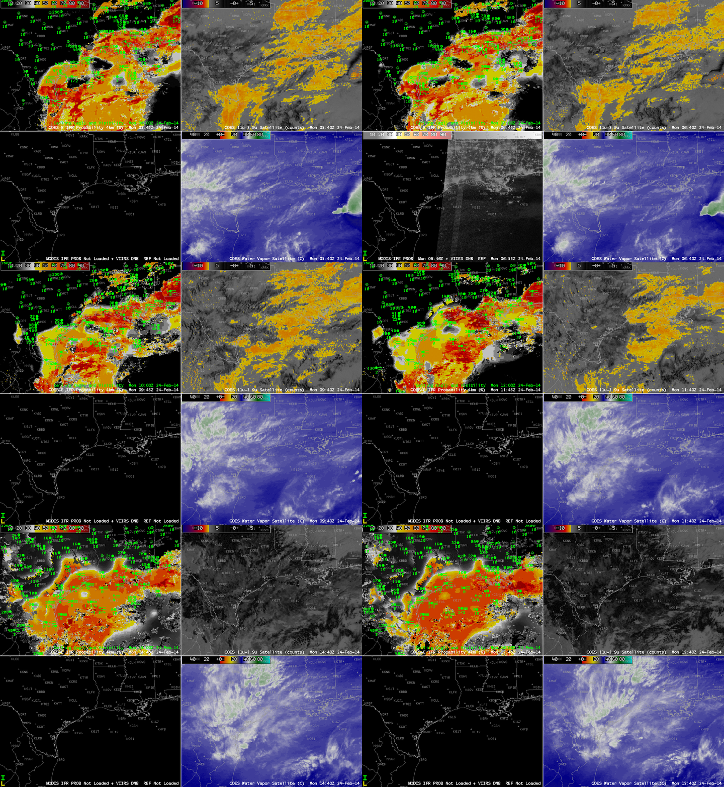
GOES-Based GOES-R IFR Probabilities (Upper Left), GOES-East Brightness Temperature Difference Fields (10.7 µm – 3.9 µm) (Upper Right), Suomi/NPP Day/Night band and MODIS-based IFR Probability fields (Lower Left), GOES-East Water Vapor Imagery (6.7 µm)(Lower Right), hourly from 0400 UTC through 1600 UTC 14 February 2014 (click image to enlarge)
IFR Probabilities are correctly limited to coastal regions of east Texas, with high values off shore. The brightness temperature difference field has difficulty identifying regions of low clouds over the Gulf of Mexico because of southwesterly flow aloft that contains mid- and high-level cloudiness. The relatively flat field over the Gulf — large values, but little variability — correspond to regions where high clouds exist. These high clouds prevent satellite predictors from being used in the IFR Probability algorithm because the brightness temperature difference does not observe low clouds, so only the Rapid Refresh model output is used to compute the IFR Probability. Therefore the IFR Probability fields are a bit flatter. Where there are breaks in the high clouds, the brightness temperature difference field can be used in the IFR Probability algorithm, and the computed IFR Probability is larger. In addition, the character of the probability field is more pixelated like a satellite image.
The bottom left image in the 4-panel composite above includes both the Day/Night band from Suomi/NPP (an image that — because of scant lunar illumination — gives little distinct information about the clouds present) and a MODIS-based IFR Probability field. For selected still imagery of ~0830 UTC Suomi/NPP click here; click here for ~0730 UTC MODIS-based IFR probability.
