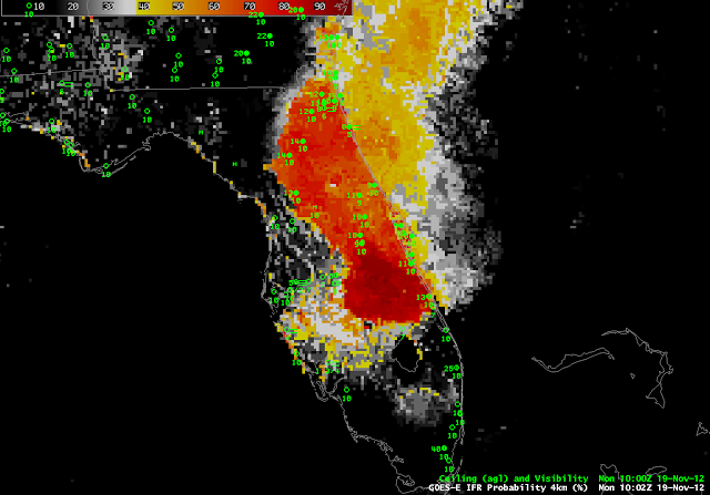
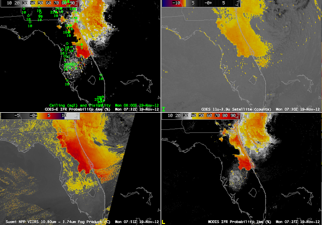
Fog and low clouds that developed over central Florida (again) on Monday morning, 19 November, highlight some strengths and shortcomings of the different fog detection techniques. The GOES-R IFR Probability (upper right) shows highest probabilities in the region where the traditional brightness temperature difference product has a distinct signal. But there is also a region of IFR probabilities (albeit low) east of Tampa Bay where the traditional brightness temperature difference product has no distinct signal. This is likely a region of developing fog/low stratus. Note that the higher-resolution Brightness Temperature Difference product from VIIRS on Suomi/NPP has a signal in that region, and the MODIS-based IFR Probability (lower right) field is also consistent with a developing fog/low stratus field. The low IFR Probabilities in the GOES-based signal should alert to the possibility of developing fog. Note that both the GOES-Based and MODIS-based IFR probabilities show a narrower strip of fog/low stratus south of Jacksonville than is represented in the GOES and Suomi/NPP Brightness Temperature Difference fields. In this region, the Rapid Refresh Model data are refining the satellite predictors to represent more accurately the distribution of fog/low stratus in the Rapid Refresh model output. The IFR Probabilities at 1000 UTC (below) shows that IFR conditions did indeed develop in that region of interior Florida to the east of Tampa.
 |
| GOES-R IFR Probabilities at 1002 UTC, computed from GOES-East and the Rapid Refresh Model |
The Traditional Brightness Temperature Difference field shows a signal that parallels the west-facing Gulf coasts of Florida. This signal arises from a co-registration error between the shortwave IR and longwave IR sensors on GOES (See this post for more examples). This co-registration error is diurnally varying and typically peaks between midnight and sunrise.

