Daily Archives: August 16, 2012

Valley Fog over Appalachia

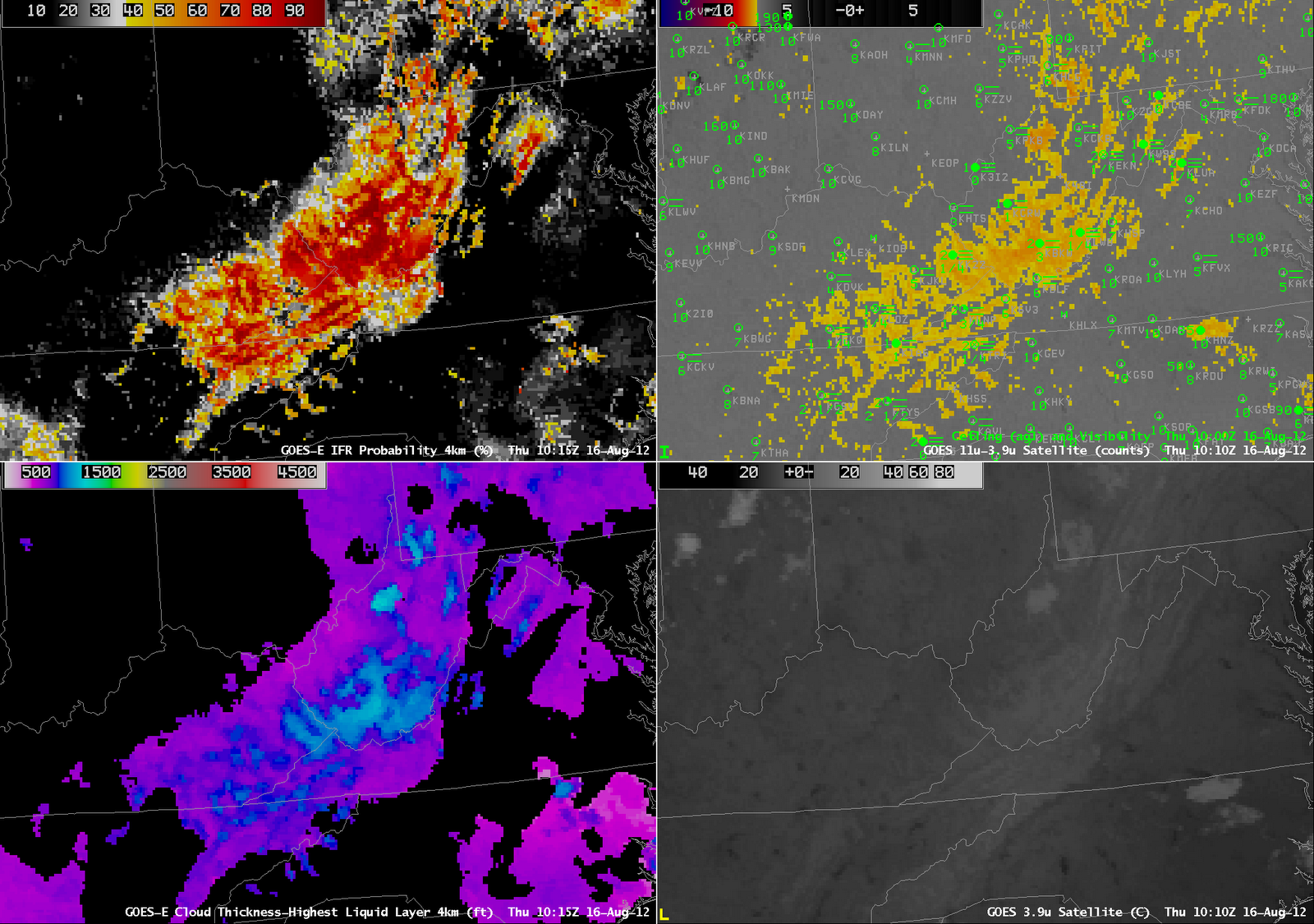
GOES-R IFR Probabilities (Upper Left), Brightness Temperature Difference (10.7 micrometers – 3.9 micrometers) (Upper Right), GOES-R Cloud Thickness (Lower Left), GOES-East 3.9 micrometer imagery (Lower Right)

The radiation fog example over West Virginia and surrounding states on 16 August highlights characteristic strengths of the GOES-R Fog/Low Stratus products.  Note, for example, how the enhanced brightness temperature field shows no apparent signal over the Ohio River Valley along the western border of West Virginia, despite the presence of IFR conditions at Pt. Pleasant (K3I2) and Huntington (KHTS).  In contrast, the IFR probability does the suggest the possibility of visibility obstructions in the valley.

Note the region of low cloud over north-central North Carolina.  The feature is quite apparent in the 3.9-micrometer imagery, and the brightness temperature difference field also has a maximum return there.  This cloud is likely elevated stratus (brightness temperatures were generally in the single digits Celsius), and the IFR Probability field correctly diminishes the strong satellite predictor signal there.

Satellite and Model Predictors of Fog

GOES-R IFR Probabilities (Upper left), Enhanced GOES-East 10.7 micrometer imagery (Upper right), Rapid Refresh Mean Relative Humidity (1000-850 mb) (Lower left), Composite Radar Reflectivity (Lower right).  Times as indicated.

A large convective system moved over Wisconsin during the morning of 16 August 2012 and it illustrates the importance of fused data in diagnosing IFR conditions.  The deep convective cloud precludes any satellite detection of low water-based clouds, so the traditional method of detecting fog/low stratus (the brightness temperature difference between 10.7 and 3.9 micrometers) cannot be used.  In this case, model data, in the form of Rapid Refresh Relative Humidity, is used to fill in regions where satellite predictors cannot help.  Note the observation of IFR conditions at Wisconsin Rapids (KISW);  this is a region of very high model relative humidity.  Model relative humidity is just as high over south-central Minnesota;  in that region, however, satellite predictors do exist, and they do not suggest fog/low clouds, so the IFR probability there is comparitively lower.

The character of the IFR probability field is much less pixelated in regions where model data only are used as predictors.  When satellite data and model data are used, as over northwest Wisconsin, for example, the pixelated nature of the satellite data becomes apparent.