Daily Archives: July 12, 2012

Fog and Low Stratus where it rains

Fog and low stratus is not rare in regions of precipitation, but the brightness temperature difference algorithm used historically to infer fog will not highlight such areas as those where IFR conditions are likely, usually because the emissivity properties of the precipitating clouds differ from those of fog/stratus decks.  The GOES-R Fog/Low Stratus product nevertheless will produce a signal in these regions because it uses input from numerical models in regions where a satellite signal cannot provide information.
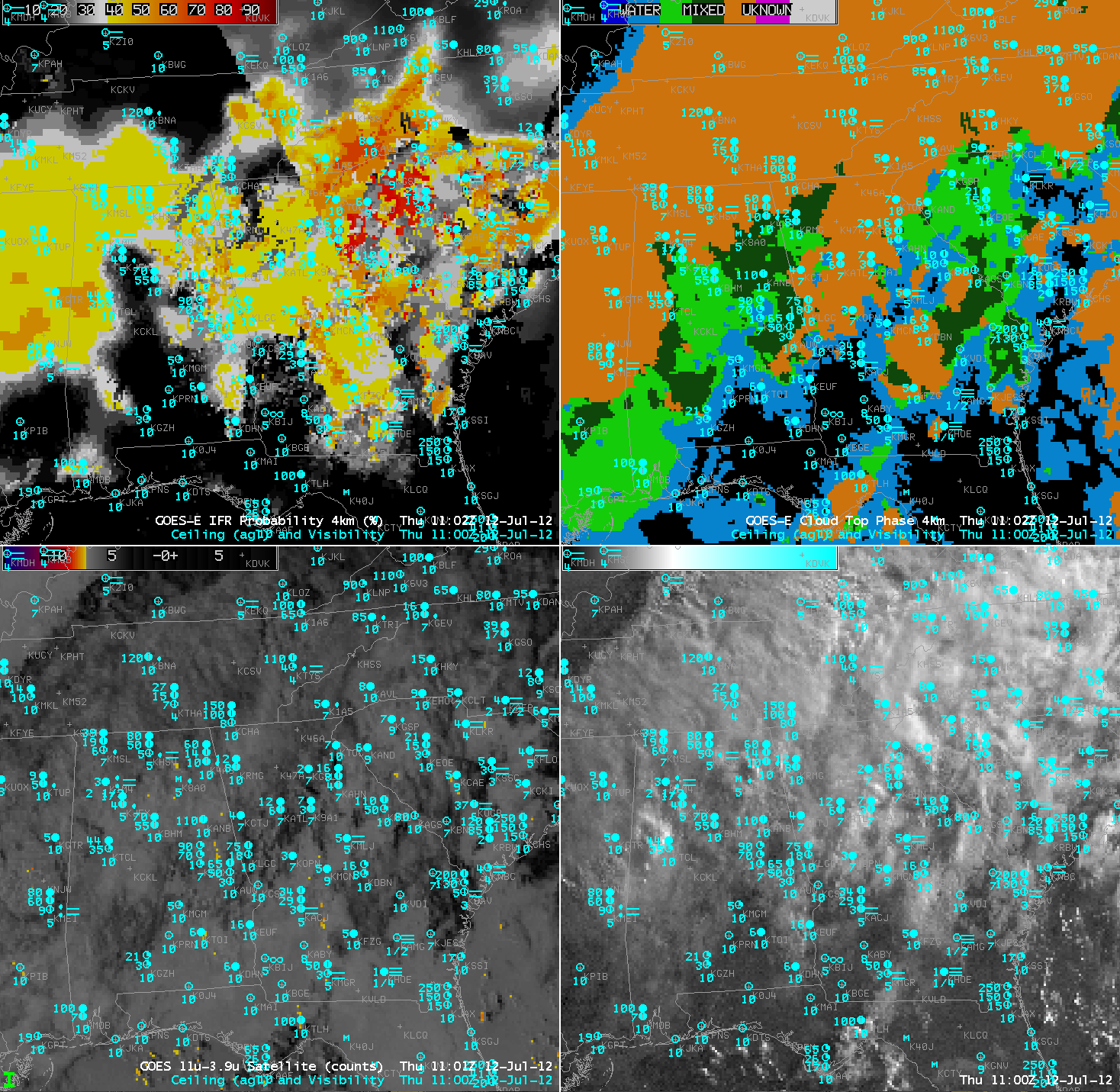
GOES-East IFR Probabilities from the GOES-R Fog/Low Stratus algorithm (upper left), GOES-East cloud phase (upper right), GOES-East brightness temperature difference (11 microns – 3.9 microns) (lower left), GOES-East visible imagery (enhanced for low light conditions) (lower right), all for 1100 UTC on 12 July 2012.

Several things require explanation in these images.  In the IFR probability mapping, the SSE to NNW boundary extending from near Jacksonville to Chattanooga is the terminator, the boundary between using nigthtime and daytime values in the look-up tables that are used to relate model and satellite fields to IFR probabilities.  Note that the daytime values generally yield higher probabilities than the nighttime values, especially for regions where IFR probabilities are determined mostly from model output.  Regions where that occurs — where model output drives the IFR probability output — are typically underneath widespread ice clouds, and the probability fields have a more uniform look to them.  In the image above, more satellite data are being used over South Carolina, and the resultant IFR probability field has a more pixelated character.  Note, however, how little information about fog and low stratus is present in the traditional brightness temperature difference field in the lower left.  IFR flight rules are common from south central Georgia northeastward into South Carolina and over northern Mississippi.

Cirrus Effects in GOES-R Fog/Low Stratus Prediction

MODIS-based IFR Probabilities (Upper Left), Cloud Thickness of the Highest Liquid Layer (Upper Right), 3.7 micron brightness temperatures (Lower Left) and MODIS Cloud Phase (Lower Right) from 1100 UTC on 12 July 2012.

A benefit of the GOES-R Fog/Low Stratus product is that it provides a signal even in the presence of higher clouds that make fog detection via brightness temperature difference methods impossible.  In this case from 1100 UTC on 12 July, a thin cirrus shield off the coast of Oregon (the bright white wisp in the 3.7 micron imagery in the bottom left) shows up (correctly) as an ice cloud in the cloud phase field (bottom right).  Note that low cloud thickness is not computed when higher clouds overlay the low cloud field — so data are available underneath the cirrus deck, although you might infer the thickness from the surrounding fields.  The GOES-R IFR probabilities show values exceeding 50% underneath the cirrus deck, in a region where the brightness temperature difference gives no information.

This effect is also seen in GOES-based imagery, below, from 1200 UTC.  The Cirrus cloud has moved onshore just south of KONP (Newport, OR) where IFR conditions exist.  The IFR probabilities suggest fog/low clouds are likely present in a region where the brightness temperature difference field gives no information because of cirrus clouds.  Although this cirrus shield is small, it should be easy to envision a larger cirrus shield and what that impact might be.

Note also the number of false positives in the brightness temperature difference field that do not show up in the IFR Probabilities.

GOES-West-based Cloud Thickness of the Highest Liquid Layer (Upper Left), IFR Probabilities (Upper Right), 11 micrometer – 3.9 micrometer brightness temperature difference (Bottom Left) and Cloud Phase (Bottom right)